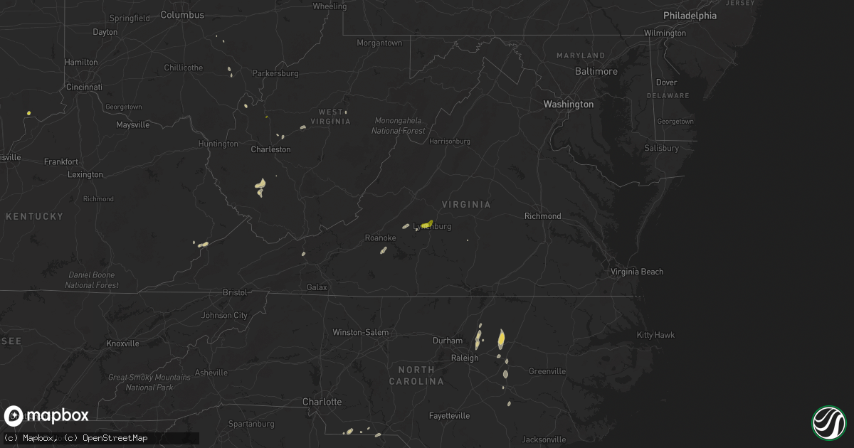
Hail Map on May 13, 2025
Get this storm
May 13 map
$229
one time, instant access
Download today. No call, no setup
Keep the $229
Bought the map and want the full workflow? Apply the entire $229 to a subscription within 7 days. None of it is wasted.
Every map, not just this one
This buys you this map. Subscription and you get every map we run, in the markets you choose from a few cities to whole states to nationwide. Plus real-time alerts the moment a storm fires.
Contact data
Name, contact info, occupancy, even credit band for addresses in the footprint. You go from where it hit to who to call.
Become the source they trust
Unlimited branding weather history reports on demand. You already have the documented answer ready for the property owner, and you are the one who showed up with it.
Property data and RoofTrace estimates
Pull up any address you have got, its value and the exact code rules for that jurisdiction, straight from One Click Code. Then RoofTrace estimates the squares, pitch, and roof value, priced the way you price.
States Impacted by Hail Map on May 13, 2025
Storm reports
Kentucky
| Date | Description |
|---|---|
| 05/13/20254:48 PM CDT | Tree down blocking plum fork in maloneton. |
| 05/13/20254:48 PM CDT | Two trees down blocking the roadway at pinson ridge and plum fork... Maloneton. Time estimated from radar. |
Indiana
| Date | Description |
|---|---|
| 05/13/20254:58 PM CDT | [landspout] a brief landspout tornado touched down and tracked through open fields for a short time. Ef-u strength. |
| 05/13/20253:10 PM CDT | Report from mping: quarter |
Virginia
| Date | Description |
|---|---|
| 05/13/20256:37 PM CDT | A local report indicates 1.00 inch wind near 3 WNW Lynchburg City |
| 05/12/20258:35 PM CDT | Tree down on river road in farmville. Time estimated. |
| 05/12/20258:10 PM CDT | Tree down on prince edward hwy east of pamplin. Time estimated. |
West Virginia
| Date | Description |
|---|---|
| 05/13/20254:45 PM CDT | A tree blew down onto morgan county road and resulted in local power outages. Time estimated by radar. |
| 05/13/20254:35 PM CDT | Quarter size hail going on at time of call... Along with very heavy rain. |
| 05/13/20252:39 PM CDT | Tree with lines down on waterloo rd. In french creek. Time estimated from radar. |
| 05/13/20252:31 PM CDT | Tree reported down. Time is estimated by radar. |
| 05/13/20252:25 PM CDT | Tree reported down near the intersection of pond fork road and millwood road. Time is estimated by radar. |
| 05/13/20252:25 PM CDT | Tree down on county route 5. Time estimated from radar. |
| 05/13/20252:20 PM CDT | Tree down at lambert btm... Bob white... Wv. Time estimated from radar. |
| 05/13/20252:05 PM CDT | Tree damage resulting in 763 customers without power. |
| 05/13/20251:54 PM CDT | Tree down in roadway blocking one lane on blair mountain hwy... Yolyn. |
| 05/13/20251:19 PM CDT | Tree reported down blocking one lane. Time is estimated by radar. |
South Dakota
| Date | Description |
|---|---|
| 05/13/20251:25 AM CDT | A local report indicates 1.00 inch wind near Lead |
North Carolina
| Date | Description |
|---|---|
| 05/13/20256:18 PM CDT | Tree down on powerlines. |
| 05/13/20255:17 PM CDT | Tree down along lake wackena drive. |
| 05/13/20252:24 PM CDT | Tree down on friendly ln. |
| 05/13/20252:20 PM CDT | Tree down at andrew hunter rd and faith rock rd. |
| 05/13/202512:20 PM CDT | Trees blocking road near intersection of miami church rd and joe bost rd. Time estimated frrom radar. |
| 05/12/20257:03 PM CDT | Tree down on powerlines. |
Illinois
| Date | Description |
|---|---|
| 05/13/20255:05 PM CDT | Multiple photos and videos of a landspout tornado in western stark county west of wyoming from broadcast media and social media. Location estimated. No damage reported. |
| 05/13/20254:24 PM CDT | Multiple photos and videos of a landspout tornado near and northeast of the fedex facility from broadcast media and social media. No damage was reported. Location estim |
| 05/13/20253:49 PM CDT | Received video of a landspout tornado just east of i-155 near us 136. No damage reported. |
Ohio
| Date | Description |
|---|---|
| 05/13/20256:59 PM CDT | Tree down across south spring st. The road was still closed as of 11:30 pm. |
| 05/13/20255:10 PM CDT | Trees and powerlines down along state route 681. |
Cities Impacted by Hail Map on May 13, 2025
- Monroe, NC
- Marshville, NC
- Wingate, NC
- Pageland, SC
- Peachland, NC
- Wadesboro, NC
- Cheraw, SC
- Chesterfield, SC
- Morven, NC
- Wallback, WV
- Newton, WV
- Mullins, SC
- Bland, VA
- Amherstdale, WV
- Yolyn, WV
- Ireland, WV
- Bim, WV
- Clothier, WV
- Jeffrey, WV
- Walkersville, WV
- Bob White, WV
- Madison, IN
- Lancaster, OH
- Point Pleasant, WV
- Letart, WV
- Logan, OH
- Junction City, OH
- Aberdeen, MS
- Elkview, WV
- Santa Claus, IN
- Ferdinand, IN
- Ripley, WV
- Charleston, WV
- Albany, OH
- Wirtz, VA
- Boones Mill, VA
- New Marshfield, OH
- Mount Olive, NC
- Seven Springs, NC
- Rocky Mount, VA
- Martinsburg, OH
- Utica, OH
- Gambier, OH
- Frazeysburg, OH
- Walhonding, OH
- Hardy, VA
- Lucama, NC
- Fremont, NC
- Whitesburg, KY
- Thornton, KY
- Goldsboro, NC
- Pikeville, NC
- Seco, KY
- Neon, KY
- Millstone, KY
- Bedford, VA
- Greensboro, AL
- Jenkins, KY
- Wilson, NC
- Bailey, NC
- Spring Hope, NC
- Nashville, NC
- Forest, VA
- Lynchburg, VA
- Castalia, NC
- Wake Forest, NC
- Rolesville, NC
- Zebulon, NC
- Youngsville, NC
- Louisburg, NC
- Madison Heights, VA
- Wendell, NC
- Franklinton, NC
- Kittrell, NC
- Pamplin, VA
- Shoshoni, WY
- Bishop, TX
- Jay Em, WY
- Lusk, WY
- Manville, WY
- Newcastle, WY
- Sundance, WY
- Lead, SD
- Taft, TX
- Sinton, TX
- Harrison, NE
- Edgemont, SD
- Hill City, SD
- Goode, VA
- Oral, SD
- Buffalo Gap, SD
- Fairburn, SD
- Hermosa, SD
- Keystone, SD
- Rapid City, SD