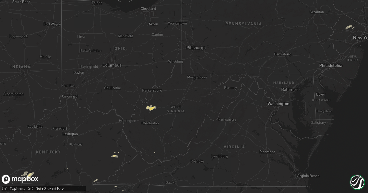
Hail Map in West Virginia on July 5, 2024
Get this storm
July 5 map
$229
one time, instant access
Download today. No call, no setup
Keep the $229
Bought the map and want the full workflow? Apply the entire $229 to a subscription within 7 days. None of it is wasted.
Every map, not just this one
This buys you this map. Subscription and you get every map we run, in the markets you choose from a few cities to whole states to nationwide. Plus real-time alerts the moment a storm fires.
Contact data
Name, contact info, occupancy, even credit band for addresses in the footprint. You go from where it hit to who to call.
Become the source they trust
Unlimited branding weather history reports on demand. You already have the documented answer ready for the property owner, and you are the one who showed up with it.
Property data and RoofTrace estimates
Pull up any address you have got, its value and the exact code rules for that jurisdiction, straight from One Click Code. Then RoofTrace estimates the squares, pitch, and roof value, priced the way you price.
Storm reports in West Virginia
West Virginia
| Date | Description |
|---|---|
| 07/05/20246:35 PM CDT | Lines down along west little kanawha highway between creston and grantsville. |
| 07/05/20246:32 PM CDT | Treed down across the road between haddox run and burton run. |
| 07/05/20246:30 PM CDT | Tree down on mountain drive. |
| 07/05/20245:45 PM CDT | Tree down blocking roadway at 179 spruce st. Davisville... Wv. |
| 07/05/20245:45 PM CDT | Tree down on ivy road. Power lines involved. |
| 07/05/20245:45 PM CDT | Tree down across triplett road. Time estimated by radar. |
| 07/05/20245:42 PM CDT | Numerous tree and power line damage in the mineral wells area. |
| 07/05/20245:40 PM CDT | Tree down on power lines across 469 dutch ridge rd... Parkersburg... Wv. |
| 07/05/20245:38 PM CDT | Numerous downed trees in the parkersburg area. Time estimated from radar. |
| 07/05/20245:38 PM CDT | Tree down near statts mills. |
| 07/05/20245:31 PM CDT | Tree down on zion ridge rd and wilbern rd. |
| 07/05/20243:56 PM CDT | Thunderstorm winds blew down a tree on indian mills road near route 12. |
All States Impacted by Hail Map on July 5, 2024
Cities Impacted by Hail Map on July 5, 2024
- Altamont, KS
- Oswego, KS
- Parsons, KS
- Scottsville, KY
- Glasgow, KY
- Smiths Grove, KY
- Fountain Run, KY
- Austin, KY
- Lucas, KY
- Eighty Eight, KY
- Summer Shade, KY
- Etoile, KY
- Anton, CO
- Whitleyville, TN
- Cope, CO
- Moss, TN
- Celina, TN
- Hilham, TN
- Oakland, KY
- Somerset, KY
- Macon, MS
- Pineville, KY
- Athens, TN
- Miracle, KY
- Patten, ME
- Scooba, MS
- Shuqualak, MS
- Riceville, TN
- Rocky Face, GA
- Decatur, TN
- Knoxville, TN
- Houlton, ME
- Hogeland, MT
- Harlem, MT
- Dalton, GA
- Bulan, KY
- Vest, KY
- Cross Plains, TX
- Hueysville, KY
- Prestonsburg, KY
- Gunlock, KY
- Leburn, KY
- Garrett, KY
- Mousie, KY
- Fall Branch, TN
- Kingsport, TN
- Drift, KY
- Printer, KY
- Langley, KY
- Alger, MI
- Raven, KY
- Wayland, KY
- Garner, KY
- Granbury, TX
- Cleburne, TX
- Dema, KY
- Prescott, MI
- Whittemore, MI
- Surgoinsville, TN
- Stephenville, TX
- Bluff Dale, TX
- Sterling, MI
- Hays, MT
- Fountain, MI
- Custer, MI
- Rogersville, TN
- Greeneville, TN
- Guadalupita, NM
- Tolar, TX
- Harrison, MI
- Lake, MI
- Murphy, NC
- Marion, MI
- Canton, TX
- Brasstown, NC
- Hayesville, NC
- Falmouth, MI
- Malta, MT
- West Forks, ME
- New Boston, TX
- McBain, MI
- Pineville, WV
- Ocate, NM
- Rutherfordton, NC
- Ranger, TX
- Gouldbusk, TX
- Rainbow, TX
- Lakemont, GA
- Doole, TX
- Toccoa, GA
- Glasgow, MT
- Power, MT
- Mora, NM
- Rainsville, NM
- Zortman, MT
- Filion, MI
- Port Hope, MI
- Hico, TX
- Iredell, TX
- Plentywood, MT
- Smithdale, MS
- Liberty, MS
- Summit, MS
- Buena Vista, NM
- Magnolia, MS
- Newellton, LA
- Fort Peck, MT
- Tallulah, LA
- Hamburg, AR
- Gladwin, MI
- Mio, MI
- Luzerne, MI
- Sikes, LA
- Capitan, NM
- Lewiston, MI
- Las Cruces, NM
- Chocowinity, NC
- Grimesland, NC
- Sapello, NM
- Las Vegas, NM
- Beaverton, MI
- Clare, MI
- Aquilla, TX
- Waco, TX
- West, TX
- Nogales, AZ
- Livonia, LA
- Oscar, LA
- Elm Mott, TX
- Lincoln, NM
- Bastrop, LA
- Ripley, WV
- Natchitoches, LA
- Given, WV
- Kenna, WV
- Tucson, AZ
- Evans, WV
- Gay, WV
- Reedy, WV
- Montgomery, LA
- Gandeeville, WV
- Le Roy, WV
- Mart, TX
- Groesbeck, TX
- Hondo, NM
- San Patricio, NM
- Glencoe, NM
- Cimarron, NM
- Notasulga, AL
- Spencer, WV
- Tinnie, NM
- Santa Rosa, NM
- Anton Chico, NM
- Sandyville, WV
- Vaughn, NM
- Smithfield, VA
- Carrollton, VA
- Sherwood, ND
- Trinidad, CO
- Bainville, MT
- Halliday, ND
- Robeline, LA
- Auburn, AL
- Ryder, ND
- Lovelady, TX
- Mayhill, NM
- Lockwood, NY
- Waverly, NY
- Roswell, NM
- Crockett, TX
- Mescalero, NM
- Del Rio, TX
- Wing, ND
- Barton, NY
- Yeso, NM
- El Paso, TX
- Midland, GA
- Fortson, GA
- Mauk, GA
- Glenmora, LA
- Effie, LA
- Hineston, LA
- Comstock, TX
- Box Springs, GA
- Columbus, GA
- Upatoi, GA
- Weed, NM
- Cloudcroft, NM
- Pinon, NM
- Marble, NC
- Albany, GA
- Solano, NM
- Conchas Dam, NM
- Erin, NY
- Sierra Blanca, TX
- Folsom, NM
- Grenville, NM
- Springer, NM
- Wharton, NJ
- Lake Hopatcong, NJ
- Wagon Mound, NM
- Oak Ridge, NJ
- Newfoundland, NJ
- Rockaway, NJ
- Boonton, NJ
- West Milford, NJ
- Butler, NJ
- Pompton Plains, NJ
- Riverdale, NJ
- Bloomingdale, NJ
- Bard, NM
- Adrian, TX
- San Jon, NM
- Turner, MT
- Medford, WI


