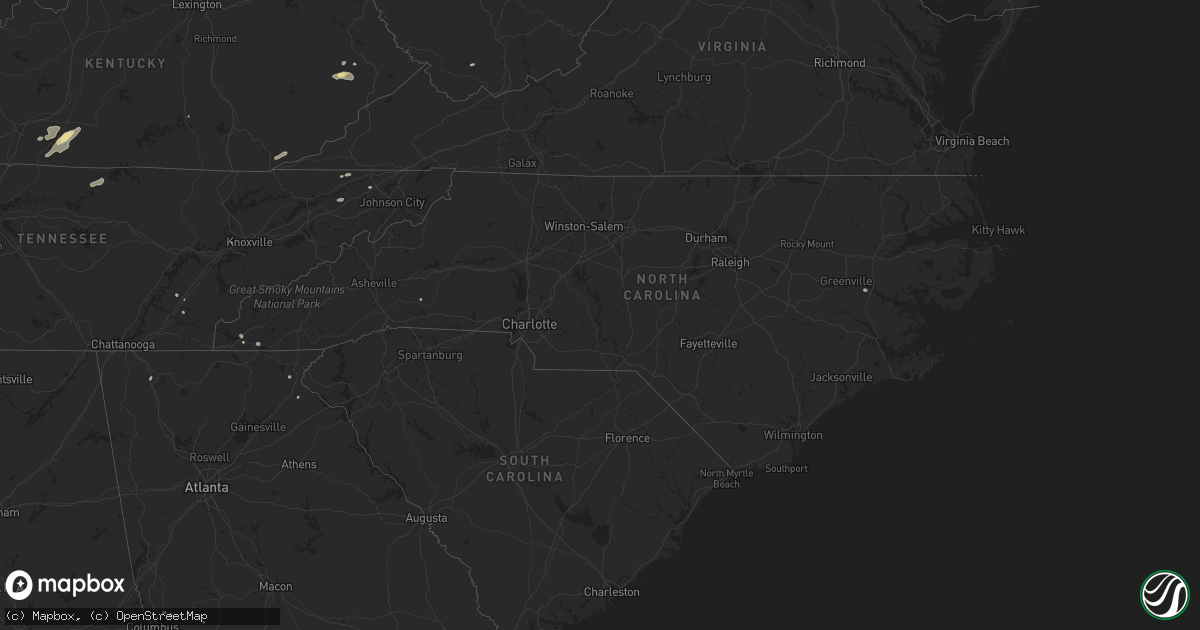
Hail Map in North Carolina on July 5, 2024
Get this storm
July 5 map
$229
one time, instant access
Download today. No call, no setup
Keep the $229
Bought the map and want the full workflow? Apply the entire $229 to a subscription within 7 days. None of it is wasted.
Every map, not just this one
This buys you this map. Subscription and you get every map we run, in the markets you choose from a few cities to whole states to nationwide. Plus real-time alerts the moment a storm fires.
Contact data
Name, contact info, occupancy, even credit band for addresses in the footprint. You go from where it hit to who to call.
Become the source they trust
Unlimited branding weather history reports on demand. You already have the documented answer ready for the property owner, and you are the one who showed up with it.
Property data and RoofTrace estimates
Pull up any address you have got, its value and the exact code rules for that jurisdiction, straight from One Click Code. Then RoofTrace estimates the squares, pitch, and roof value, priced the way you price.
Storm reports in North Carolina
North Carolina
| Date | Description |
|---|---|
| 07/05/20245:19 PM CDT | Thunderstorm winds blew down a tree blocking both lanes of traffic on brim road near mount herman church road. |
| 07/05/20245:11 PM CDT | Thunderstorm winds blew down a tree onto a powerline causing a fire on east pine street. |
| 07/05/20245:10 PM CDT | Thunderstorm winds blew down a tree and powerlines on slate mountain road near westfield road. |
| 07/05/20245:09 PM CDT | Thunderstorm winds blew down a tree blocking the whole roadway on mathis road near hills presbyterian church road. |
| 07/05/20245:05 PM CDT | Tree blocking road at snody road and simmons road intersection. |
| 07/05/20245:04 PM CDT | Thunderstorm winds blew down a tree blocking both lanes of traffic on old westfield road. |
| 07/05/20245:04 PM CDT | Thunderstorm winds blew down a tree crossing the road and power lines were blown down into a yard on lovill circle. |
| 07/05/20245:01 PM CDT | Thunderstorm winds blew down a tree blocking one lane of travel on highland drive. |
| 07/05/20245:01 PM CDT | Small tree blown down on spring street. |
| 07/05/20244:55 PM CDT | Thunderstorm winds blew down a large tree blocking lanes of traffic on reeves mill road. |
| 07/05/20244:55 PM CDT | Thunderstorm winds blew down a tree on park drive near i-74 east. |
| 07/05/20244:45 PM CDT | Thunderstorm winds blew down a tree blocking the whole roadway on old u.s 601. |
| 07/05/20244:41 PM CDT | Thunderstorm winds blew down and snapped at least 10 to 20 trees and threw a 10 by 12 foot playhouse off the ground. |
| 07/05/20244:39 PM CDT | Thunderstorm winds blew down a tree blocking both lanes of traffic on george chandler road near beechnut lane. |
| 07/05/20244:35 PM CDT | Thunderstorm winds blew down a tree blocking the whole roadway on red hill creek road near haystack road. |
| 07/05/20244:31 PM CDT | Thunderstorm winds blew down at least one tree on nc 268 near friendship motor speedway. Tree is blocking whole roadway. |
| 07/05/20244:15 PM CDT | Tree blocking road at old quarry road and muddy flats road. |
| 07/05/20244:15 PM CDT | Thunderstorm winds blew down a tree on fax welborn road. Tree fell on power line. |
| 07/05/20244:13 PM CDT | Thunderstorm winds blew down a tree in the roadway on pine swamp road. Report came from social media. |
| 07/05/20244:05 PM CDT | Trees and power lines down across the city of morganton... Including on ervin rd and burkemont ave. |
| 07/05/20243:48 PM CDT | Trees down in 5000 block of patton rd and in 4800 block of elmore dr... Both southwest of morganton. Time estimated. |
| 07/05/20243:44 PM CDT | Thunderstorm winds destroyed two barns and blew down several trees on brown mountain road. |
| 07/05/20243:30 PM CDT | Thunderstorm winds blew down several trees on cook road. |
| 07/05/20243:25 PM CDT | A few trees down in vicinity of duncans creek rd and bostic sunshine hwy. Time estimated. |
| 07/05/20243:25 PM CDT | Large 10 inch diameter tree limbs blown down. |
| 07/05/20243:20 PM CDT | Tree down and power outage in highlands. Another tree down on flat mtn rd north of highlands. Time estimated. |
| 07/05/20243:11 PM CDT | Power outage attributed to fallen trees or limbs reported at 4:20 pm. Time of damage estimated based on radar. |
| 07/05/20243:04 PM CDT | Tree down on tessentee rd. Time estimated. |
| 07/05/20242:52 PM CDT | Tree down on standing indian campground rd. Time estimated. |
All States Impacted by Hail Map on July 5, 2024
Cities Impacted by Hail Map on July 5, 2024
- Altamont, KS
- Oswego, KS
- Parsons, KS
- Scottsville, KY
- Glasgow, KY
- Smiths Grove, KY
- Fountain Run, KY
- Austin, KY
- Lucas, KY
- Eighty Eight, KY
- Summer Shade, KY
- Etoile, KY
- Anton, CO
- Whitleyville, TN
- Cope, CO
- Moss, TN
- Celina, TN
- Hilham, TN
- Oakland, KY
- Somerset, KY
- Macon, MS
- Pineville, KY
- Athens, TN
- Miracle, KY
- Patten, ME
- Scooba, MS
- Shuqualak, MS
- Riceville, TN
- Rocky Face, GA
- Decatur, TN
- Knoxville, TN
- Houlton, ME
- Hogeland, MT
- Harlem, MT
- Dalton, GA
- Bulan, KY
- Vest, KY
- Cross Plains, TX
- Hueysville, KY
- Prestonsburg, KY
- Gunlock, KY
- Leburn, KY
- Garrett, KY
- Mousie, KY
- Fall Branch, TN
- Kingsport, TN
- Drift, KY
- Printer, KY
- Langley, KY
- Alger, MI
- Raven, KY
- Wayland, KY
- Garner, KY
- Granbury, TX
- Cleburne, TX
- Dema, KY
- Prescott, MI
- Whittemore, MI
- Surgoinsville, TN
- Stephenville, TX
- Bluff Dale, TX
- Sterling, MI
- Hays, MT
- Fountain, MI
- Custer, MI
- Rogersville, TN
- Greeneville, TN
- Guadalupita, NM
- Tolar, TX
- Harrison, MI
- Lake, MI
- Murphy, NC
- Marion, MI
- Canton, TX
- Brasstown, NC
- Hayesville, NC
- Falmouth, MI
- Malta, MT
- West Forks, ME
- New Boston, TX
- McBain, MI
- Pineville, WV
- Ocate, NM
- Rutherfordton, NC
- Ranger, TX
- Gouldbusk, TX
- Rainbow, TX
- Lakemont, GA
- Doole, TX
- Toccoa, GA
- Glasgow, MT
- Power, MT
- Mora, NM
- Rainsville, NM
- Zortman, MT
- Filion, MI
- Port Hope, MI
- Hico, TX
- Iredell, TX
- Plentywood, MT
- Smithdale, MS
- Liberty, MS
- Summit, MS
- Buena Vista, NM
- Magnolia, MS
- Newellton, LA
- Fort Peck, MT
- Tallulah, LA
- Hamburg, AR
- Gladwin, MI
- Mio, MI
- Luzerne, MI
- Sikes, LA
- Capitan, NM
- Lewiston, MI
- Las Cruces, NM
- Chocowinity, NC
- Grimesland, NC
- Sapello, NM
- Las Vegas, NM
- Beaverton, MI
- Clare, MI
- Aquilla, TX
- Waco, TX
- West, TX
- Nogales, AZ
- Livonia, LA
- Oscar, LA
- Elm Mott, TX
- Lincoln, NM
- Bastrop, LA
- Ripley, WV
- Natchitoches, LA
- Given, WV
- Kenna, WV
- Tucson, AZ
- Evans, WV
- Gay, WV
- Reedy, WV
- Montgomery, LA
- Gandeeville, WV
- Le Roy, WV
- Mart, TX
- Groesbeck, TX
- Hondo, NM
- San Patricio, NM
- Glencoe, NM
- Cimarron, NM
- Notasulga, AL
- Spencer, WV
- Tinnie, NM
- Santa Rosa, NM
- Anton Chico, NM
- Sandyville, WV
- Vaughn, NM
- Smithfield, VA
- Carrollton, VA
- Sherwood, ND
- Trinidad, CO
- Bainville, MT
- Halliday, ND
- Robeline, LA
- Auburn, AL
- Ryder, ND
- Lovelady, TX
- Mayhill, NM
- Lockwood, NY
- Waverly, NY
- Roswell, NM
- Crockett, TX
- Mescalero, NM
- Del Rio, TX
- Wing, ND
- Barton, NY
- Yeso, NM
- El Paso, TX
- Midland, GA
- Fortson, GA
- Mauk, GA
- Glenmora, LA
- Effie, LA
- Hineston, LA
- Comstock, TX
- Box Springs, GA
- Columbus, GA
- Upatoi, GA
- Weed, NM
- Cloudcroft, NM
- Pinon, NM
- Marble, NC
- Albany, GA
- Solano, NM
- Conchas Dam, NM
- Erin, NY
- Sierra Blanca, TX
- Folsom, NM
- Grenville, NM
- Springer, NM
- Wharton, NJ
- Lake Hopatcong, NJ
- Wagon Mound, NM
- Oak Ridge, NJ
- Newfoundland, NJ
- Rockaway, NJ
- Boonton, NJ
- West Milford, NJ
- Butler, NJ
- Pompton Plains, NJ
- Riverdale, NJ
- Bloomingdale, NJ
- Bard, NM
- Adrian, TX
- San Jon, NM
- Turner, MT
- Medford, WI


