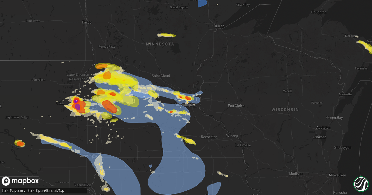
Hail Map on July 27, 2025
Get this storm
July 27 map
$229
one time, instant access
Download today. No call, no setup
Keep the $229
Bought the map and want the full workflow? Apply the entire $229 to a subscription within 7 days. None of it is wasted.
Every map, not just this one
This buys you this map. Subscription and you get every map we run, in the markets you choose from a few cities to whole states to nationwide. Plus real-time alerts the moment a storm fires.
Contact data
Name, contact info, occupancy, even credit band for addresses in the footprint. You go from where it hit to who to call.
Become the source they trust
Unlimited branding weather history reports on demand. You already have the documented answer ready for the property owner, and you are the one who showed up with it.
Property data and RoofTrace estimates
Pull up any address you have got, its value and the exact code rules for that jurisdiction, straight from One Click Code. Then RoofTrace estimates the squares, pitch, and roof value, priced the way you price.
States Impacted by Hail Map on July 27, 2025
Storm reports
District of Columbia
| Date | Description |
|---|---|
| 07/27/202512:38 PM CDT | Report of trees down along the 800 block of atlantic st se and 400 block of brandywine st se. |
South Dakota
| Date | Description |
|---|---|
| 07/27/20256:54 PM CDT | A local report indicates 1.50 inch wind near 1 SW Watertown |
| 07/27/20256:53 PM CDT | Asos station katy watertown muni ap. |
| 07/27/20256:40 PM CDT | A local report indicates 2.75 inch wind near Watertown Airport |
| 07/27/20256:26 PM CDT | A local report indicates 1.75 inch wind near 4 NW Rauville |
| 07/27/20255:58 PM CDT | Several storm chasers have reported a tornado. |
| 07/27/202511:55 AM CDT | An nws employee estimated up to 60 mph winds between 11:50 pm to 12:00 am. |
| 07/27/20251:36 AM CDT | An sddot in north sioux city recorded a 59 mph wind gust. |
| 07/26/202511:55 PM CDT | Corrects previous tstm wnd gst report from 4 se sioux falls. An nws employee estimated up to 60 mph winds between 11:50 pm to 12:00 am. |
| 07/26/202511:52 PM CDT | A personal weather station near harrisburg recorded a 65 mph wind gust. |
| 07/26/202511:49 PM CDT | A personal weather station near harrisburg... Sd recorded a 60 mph wind gust. |
| 07/26/202511:06 PM CDT | Sddot site near montrose recorded a 59 mph wind gust. |
| 07/26/202510:38 PM CDT | A personal weather station southeast of canova recorded a 62 mph wind gusts. Time estimated via radar. |
| 07/26/20259:55 PM CDT | A local report indicates 65 MPH wind near 3 ENE Letcher |
| 07/26/20258:25 PM CDT | A local report indicates 1.00 inch wind near Castlewood |
| 07/26/20258:05 PM CDT | A local report indicates 1.00 inch wind near 5 S Keyapaha |
| 07/26/20258:00 PM CDT | A local report indicates 1.75 inch wind near 3 NW Castlewood |
| 07/26/20257:40 PM CDT | Radar estimated time. |
| 07/26/20257:37 PM CDT | A local report indicates 1.00 inch wind near 6 NW Clearfield |
| 07/26/20257:12 PM CDT | Also reported limbs down. |
North Carolina
| Date | Description |
|---|---|
| 07/27/20256:43 PM CDT | 1 tree down at us 1 and main st. |
| 07/27/20254:19 PM CDT | Approximately 75 power outages near mackleyville. |
| 07/27/20254:00 PM CDT | Craven county 911 center reported power line damage in james city. |
| 07/27/20253:41 PM CDT | Delayed report.... Duplin county dot reported a tree down across hwy 903 as thunderstorms moved through the area. Time estimated by radar. |
| 07/27/20253:15 PM CDT | Anchored outdoor furniture ripped out of the ground. |
| 07/27/20252:53 PM CDT | Power lines reported down along tyler road in kinston. |
| 07/27/20252:00 PM CDT | Tree down on a powerline on nc 168 in barco. Time estimated. |
| 07/26/20258:52 PM CDT | Duke energy reported fallen trees or powerlines damaging their equipment... Causing power outages. |
| 07/26/20258:42 PM CDT | 1 tree down at us 1 and quail ridge dr. |
| 07/26/20257:45 PM CDT | 1 tree down at martin rd and mill rd. |
| 07/26/20257:23 PM CDT | One tree down in 600 block of morgan creek rd. |
| 07/26/20257:12 PM CDT | One tree down in 200 block of s main st. |
| 07/26/20257:07 PM CDT | One tree down at jones ferry rd and damascus church rd. |
| 07/26/20257:03 PM CDT | Multiple trees down in 2300 block of white cross rd. |
Ohio
| Date | Description |
|---|---|
| 07/27/20255:05 PM CDT | Tree and lines down near intersection of county road 123 and private drive 142. Time estimated from radar. |
| 07/27/20251:22 PM CDT | Several large branches were downed along town highway 34a near white oak road. |
Kentucky
| Date | Description |
|---|---|
| 07/27/20254:45 PM CDT | Tree reported down on wildcat lane. Time estimated from radar. |
Minnesota
| Date | Description |
|---|---|
| 07/27/20256:18 PM CDT | A local report indicates 1.00 inch wind near Chokio |
| 07/27/20255:45 PM CDT | A local report indicates 1.50 inch wind near Johnson |
| 07/27/20255:40 PM CDT | Grain bins buckled near sunburg. |
| 07/27/20255:35 PM CDT | Mesonet station mn136 t.h.9 - murdock - mp 24.5. |
| 07/27/20255:25 PM CDT | Mesonet station mn136 t.h.9 - murdock - mp 24.5. |
| 07/27/20255:20 PM CDT | Mesonet station mn037 t.h.29 - starbuck - mp 46. |
| 07/27/20255:20 PM CDT | Mesonet station mn134 u.s.12 - holloway - mp 27.0. |
| 07/27/20255:18 PM CDT | Multiple large branches down. |
| 07/27/20255:04 PM CDT | Power poles down in and near chokio. |
| 07/27/20254:57 PM CDT | A local report indicates 1.25 inch wind near Morris |
| 07/27/20254:46 PM CDT | A local report indicates 1.00 inch wind near Alberta |
| 07/27/20254:46 PM CDT | Measured at morris municipal airport. |
| 07/27/20254:45 PM CDT | A local report indicates 1.00 inch wind near Alberta |
| 07/27/20254:43 PM CDT | Relayed via em. |
| 07/27/20254:31 PM CDT | A local report indicates 60 MPH wind near Chokio |
| 07/27/20254:12 PM CDT | A local report indicates 1.50 inch wind near Herman |
| 07/27/20254:05 PM CDT | Ndawn station reporting 10 m |
| 07/27/202512:50 PM CDT | Large trees and power lines down near the city of watson. Time estimated from radar. |
| 07/27/202512:39 PM CDT | Photos on social media of snapped power pole and several large tree limbs down onto a house. |
| 07/27/202512:37 PM CDT | Report of numerous large trees down between milan and chippewa county road 32. Time estimated from radar. |
| 07/27/202512:25 PM CDT | Report of tornado southwest of appleton near the minnesota river. |
| 07/27/202512:03 PM CDT | Mostly nickel sized hail but a few quarters also. |
| 07/27/20257:55 AM CDT | A local report indicates 1.00 inch wind near 1 ESE Aitkin |
| 07/27/20257:53 AM CDT | Hail currently falling with not much wind. |
| 07/27/20257:17 AM CDT | Public report relayed via broadcast media partner. Picture of an uprooted tree fallen onto the street. |
| 07/27/20257:16 AM CDT | Pictures via social media of a couple uprooted and broken trees. Time estimated from radar. |
| 07/27/20257:04 AM CDT | *** 1 inj *** a tree fell at a campground on stubler lake landing on a tent and injuring a 7 year old boy. |
| 07/26/202511:35 PM CDT | Mesonet station mn144 u.s.218 - lyle - mp 4. |
| 07/26/202511:25 PM CDT | Mesonet station mn144 us 218 at lyle at mp 4. |
| 07/26/202510:50 PM CDT | Downed trees. Time estimated via radar. |
| 07/26/20259:25 PM CDT | A local report indicates 1.00 inch wind near Marshall |
| 07/26/20259:14 PM CDT | A local report indicates 1.00 inch wind near 3 SW Lakeville |
| 07/26/20258:20 PM CDT | Relayed via fsd. |
| 07/26/20258:16 PM CDT | Asos station kstp st. Paul dwtn ap. |
| 07/26/20258:04 PM CDT | A local report indicates 60 MPH wind near 1 SSW Roseville |
| 07/26/20258:03 PM CDT | A local report indicates 1.75 inch wind near 2 ESE Falcon Heights |
| 07/26/20258:03 PM CDT | Report from mping: quarter |
| 07/26/20258:02 PM CDT | Corrects previous non-tstm wnd dmg report from 3 wnw mendota. Multiple trees down taking down power lines with time estimated based on radar. (mp |
| 07/26/20258:02 PM CDT | Corrects previous non-tstm wnd dmg report from 3 wnw mendota. Multiple trees down taking down power lines with time estimated based on radar. |
| 07/26/20257:51 PM CDT | A local report indicates 1.75 inch wind near Plymouth |
| 07/26/20257:48 PM CDT | Asos station kmic crystal ap. |
| 07/26/20257:47 PM CDT | Report from mping: half dollar |
| 07/26/20257:40 PM CDT | A local report indicates 1.00 inch wind near Plymouth |
| 07/26/20257:29 PM CDT | A local report indicates 1.25 inch wind near 1 N Litchfield |
| 07/26/20257:05 PM CDT | A local report indicates 61 MPH wind near 2 ESE Buffalo |
Michigan
| Date | Description |
|---|---|
| 07/27/20252:38 PM CDT | Pea to quarter size hail. |
| 07/27/20252:33 PM CDT | From facebook comment with picture showing hail in hand. When asked... Replied that a few were quarter sized... But most marble sized. Time of occurrence estimated by r |
| 07/27/20252:13 PM CDT | A local report indicates 1.00 inch wind near 2 E Chatham |
| 07/27/20252:09 PM CDT | A local report indicates 1.00 inch wind near Chatham |
| 07/27/20251:50 PM CDT | A local report indicates 1.00 inch wind near 2 N Sundell |
Montana
| Date | Description |
|---|---|
| 07/26/202510:03 PM CDT | Mesonet station gw0718 joplin 25nnw. |
| 07/26/20259:50 PM CDT | Mesonet station gw2412 hill 2sw. |
| 07/26/20259:00 PM CDT | Mesonet station gw5346 devon three west. |
| 07/26/20258:55 PM CDT | A local report indicates 1.00 inch wind near 11 NNW Harlowton |
| 07/26/20258:41 PM CDT | Report from mping: quarter |
Nevada
| Date | Description |
|---|---|
| 07/26/202510:30 PM CDT | Public reported 1 inch hail verified with a photo. |
Maryland
| Date | Description |
|---|---|
| 07/27/20252:25 PM CDT | Numerous trees blew down in southern calvert county. |
| 07/27/20252:14 PM CDT | Wind gusts of up to 57 knots |
| 07/27/20252:14 PM CDT | Wind gusts |
| 07/27/20251:59 PM CDT | Report of a tree on a house west of waldorf on pimpernel drive |
| 07/27/20251:58 PM CDT | Trees blew down between port tobacco and bel alton... Including on md-6 port tobacco road east of rose hill road. |
| 07/27/20251:58 PM CDT | A local report indicates 0 MPH wind near 1 W Bel Alton |
| 07/27/20251:58 PM CDT | Numerous reports of trees and power lines down across the city. |
| 07/27/20251:55 PM CDT | Tree down on route 50 at bay acres drive. |
| 07/27/20251:47 PM CDT | Numerous reports of trees and power lines down across the city. |
| 07/27/20251:32 PM CDT | Corrects previous tstm wnd dmg report from stevensville. Tree down on walker road at whispering court. |
| 07/27/20251:00 PM CDT | Report of a tree on a house west of waldorf on pimpernel drive |
| 07/27/202512:56 PM CDT | Multiple trees blew down on md-210 indian head highway near fort washington road. |
Iowa
| Date | Description |
|---|---|
| 07/27/20253:21 AM CDT | Roof blown off a home. |
| 07/27/20252:30 AM CDT | An emergency manager relayed a report of a 70 mph wind gust at the woodbury county fairgrounds in moville... Ia. |
| 07/27/20252:30 AM CDT | An emergency manager relayed a report of a 70 mph wind |
| 07/27/20252:30 AM CDT | An emergency manager relayed a rep |
| 07/27/20252:30 AM CDT | An emergency manager relayed a r |
| 07/27/20252:30 AM CDT | An emergency manager relayed a report of a 70 mph wind gust at the woodbury county fairgrounds in |
| 07/27/20251:45 AM CDT | Some significant tree branch damage... 1-3 inches in diameter. Also reports of down field corn. |
| 07/27/20251:43 AM CDT | A personal weather station northeast of ida grove recorded a 64 mph wind gust. |
| 07/27/20251:40 AM CDT | Woodbury county em reported 4 inch tree limbs down in hornick. Time estimated via radar. |
| 07/27/20251:36 AM CDT | Spotty minor tree damage across town... With scattered small branches and leaves blown down. |
| 07/27/20251:35 AM CDT | A delayed report of a nine inch tree downed by thunderstorm winds four miles west of stanley. |
| 07/27/20251:14 AM CDT | A local report indicates 59 MPH wind near Waterloo Regional Airpo |
| 07/27/20251:08 AM CDT | Several large branches down. |
| 07/27/20251:08 AM CDT | A local report indicates 64 MPH wind near Sumner |
| 07/27/20251:05 AM CDT | A tree was knocked down onto a house... Another tree fell across a city street... And a couple power lines were down from broken tree branches. |
| 07/27/202512:55 AM CDT | A local report indicates 64 MPH wind near Janesville |
| 07/27/202512:55 AM CDT | A 58 mph wind gust was recorded at the sioux county regional airport. |
| 07/27/202512:40 AM CDT | A personal weather station near orange city recorded a 60 mph wind gust. |
| 07/27/202512:34 AM CDT | A personal weather station near rock rapids recorded a 62 mph wind gust. |
| 07/27/202512:30 AM CDT | Personal weather station wind gust report. |
| 07/27/202512:26 AM CDT | Tree limbs up to 3-4 inches in thickness down. |
| 07/27/202512:22 AM CDT | A personal weather station near sioux center recorded a 59 mph wind gust. Time estimated via radar. |
| 07/26/202511:58 PM CDT | Emergency manager reported a tree down in the city of rockford. |
| 07/26/202511:53 PM CDT | 911 call center reported multiple trees down in the city of osage. |
| 07/26/202511:49 PM CDT | Emergency manager reported trees down in nora springs. |
| 07/26/202511:30 PM CDT | Many branches down... With a few sized 3 inches or larger in diameter. |
| 07/26/202511:26 PM CDT | Social media report of several tree limbs down. Time of occurrence estimated from radar. |
| 07/26/202511:26 PM CDT | Measured by public weather station. |
| 07/26/202511:26 PM CDT | Large limbs down in plymouth and rock falls. Tree on vehicle in rock falls. |
| 07/26/202511:19 PM CDT | Delayed report. Trees and branches down across town. Some trees on vehicles. Several power poles reported to be on fire with power outages in the county. |
| 07/26/202511:19 PM CDT | Report of a large tree split and blown down in britt. Time estimated. Delayed report. |
| 07/26/202511:17 PM CDT | Measured by mason city asos. (d |
| 07/26/202511:17 PM CDT | Measured by public weather station. |
| 07/26/202511:17 PM CDT | Measured by mason city asos. |
| 07/26/202511:12 PM CDT | Measured by public weather station. |
| 07/26/202510:57 PM CDT | Tree limbs down... As well as corn stalks blown over. |
| 07/26/202510:45 PM CDT | A trained spotter reported 3 inch tree limbs down and a downed tree in spirit lake. Time estimated via radar. |
West Virginia
| Date | Description |
|---|---|
| 07/27/20256:21 PM CDT | Tree downed by thunderstorm winds near the intersection of bluecourt road and red oak ridge road... And partially blocked the road. |
| 07/27/20256:21 PM CDT | Tree downed by thunderstorm winds on rattlesnake ridge road. |
| 07/27/20256:15 PM CDT | Tree reported down on south sandbranch road... Time estimated from radar. |
| 07/27/20255:25 PM CDT | Tree down near intersection of fields creek rd and haven ln. Time estimated from radar. |
| 07/27/20254:40 PM CDT | Tree down on johns fork road. Time estimated from radar. |
| 07/27/20254:15 PM CDT | Tree and lines down across clendenin creek rd... A half mile from wv 34. Time estimated from radar. |
| 07/27/20253:35 PM CDT | Tree reported down across the railroad tracks along ravenswood road... Near the little sandy creek bridge. Time estimated from radar. |
| 07/27/20253:30 PM CDT | Report of a tree and lines down across trace fork road south of sandyville. Time estimated from radar. |
| 07/27/20252:45 PM CDT | Large tree down near intersection of ray young rd and alexander rd. Time estimated from radar. |
| 07/27/20252:35 PM CDT | Tree down reported on pringle tree park road. Time estimated from radar. |
Virginia
| Date | Description |
|---|---|
| 07/27/20256:54 PM CDT | Tree downed by thunderstorm winds near the intersection of eilliott road and east ferry road... And completely blocked the road. |
| 07/27/20256:45 PM CDT | Tree knocked down along monroe rd near delaware rd resulting in lane closures. Time estimated from radar. |
| 07/27/20256:40 PM CDT | Tree down on head of river rd in chesapeake. Time estimated. |
| 07/27/20256:35 PM CDT | Tree downed by thunderstorm winds on bear creek road... And partially blocked the road. |
| 07/27/20256:30 PM CDT | Tree down near the intersection of indian trail and kings fork rd in suffolk. Time estimated. |
| 07/27/20256:28 PM CDT | Tree down near krantzs corner rd. |
| 07/27/20256:25 PM CDT | Several reports of trees and powerlines down across the county. |
| 07/27/20256:05 PM CDT | Tree down on holly farms rd near dutchtown rd in nottoway county. Time estimated. |
| 07/27/20256:03 PM CDT | Tree knocked down along smith st and rolfe hwy resulting in lane closures. Time estimated from radar. |
| 07/27/20255:57 PM CDT | Tree down on kings road partially blocking it. |
| 07/27/20255:57 PM CDT | Tree blown down on partridge creek road blocking entire road. |
| 07/27/20255:55 PM CDT | Corrects time of damage. Tree down blocking lowe street. |
| 07/27/20255:55 PM CDT | Tree down blocking izaak walton road. |
| 07/27/20255:43 PM CDT | Tree down blocking braxton ridge road. |
| 07/27/20255:30 PM CDT | Tree down on roxbury rd near barnetts rd in charles city county. (ak |
| 07/27/20255:30 PM CDT | Tree down on roxbury rd near barnetts rd in charles city county. |
| 07/27/20255:30 PM CDT | Tree down on cook rd in powhatan county. Time estimated. |
| 07/27/20255:30 PM CDT | Large tree down on oak lane. Time estimated. |
| 07/27/20255:25 PM CDT | Tree downed by thunderstorm winds at the intersection of west james anderson highway and meadow creek road. |
| 07/27/20255:25 PM CDT | Trees down around disputanta. Time estimated. |
| 07/27/20255:15 PM CDT | Tree down in roadway on barnetts road near wayside road. Time estimated. |
| 07/27/20255:15 PM CDT | Tree downed by thunderstorm winds at the intersection of south james river road and meadow creek road. |
| 07/27/20255:06 PM CDT | Tree downed by thunderstorm winds at the intersection of spreading oak road and sharon church road. |
| 07/27/20255:02 PM CDT | Tree downed by thunderstorm winds at the intersection of gravel hill road and north james madison highway. |
| 07/27/20254:41 PM CDT | Tree downed by thunderstorm winds at the intersection of snowden road and south constitution road. |
| 07/27/20254:40 PM CDT | Part of i-295 is blocked due to a tree down in the roadway in henrico county near mm 42. |
| 07/27/20254:40 PM CDT | Portion of the rd blocked on rt 1032 in goochland county due to a tree down. Time estimated. |
| 07/27/20254:40 PM CDT | Tree down on pemberton road near i-64 in henrico county. |
| 07/27/20254:40 PM CDT | Tree down in the road near intersection of willis rd and ark rd in gloucester county. Time estimated. |
| 07/27/20254:37 PM CDT | Large tree on a house on the 7700 block of wall grove ct. Time estimated. |
| 07/27/20254:37 PM CDT | A tree was reported down around the 1000 block of james river road. |
| 07/27/20254:35 PM CDT | Trees and wires blew down in the 2100 block of va-693 salem road causing a fire. |
| 07/27/20254:35 PM CDT | Multiple trees down on west river rd in fluvanna county. Time estimated. |
| 07/27/20254:35 PM CDT | Tree down on a powerline on james madison hwy in fluvanna county. Time estimated. |
| 07/27/20254:35 PM CDT | A tree was reported down along tillman lane... Not far from rockfish river road. |
| 07/27/20254:32 PM CDT | A report of trees down along langhorne road/route 626 near rock castle creek. |
| 07/27/20254:30 PM CDT | Multiple trees down on dobby creek rd and paynes landing rd in fluvanna county. Time estimated. |
| 07/27/20254:30 PM CDT | A tree and powerlines down in the roadway near the intersection of ashland rd and cedar ln in hanover county. Time estimated from radar. |
| 07/27/20254:20 PM CDT | Tree down in the road on us-1 north of doswell. |
| 07/27/20254:15 PM CDT | Multiple large trees down at 14490 new found rd. Time estimated from radar. |
| 07/27/20254:11 PM CDT | Tree down blocking the road on sr 715 near the town of green bay. Time estimated from radar. |
| 07/27/20254:08 PM CDT | Report of trees down along red hill school road/route 760 to the east of taylors gap road. |
| 07/27/20253:58 PM CDT | Tree down in the roadway on va-3 in richmond county. |
| 07/27/20253:30 PM CDT | Trees blew down along va-632 south roxbury mills road. |
| 07/27/20253:30 PM CDT | Multiple trees down in louisa in addition to one downed power line. Time estimated. |
| 07/27/20253:25 PM CDT | Tree blocking havelock rd in richmond county. Time estimated from radar. |
| 07/27/20253:14 PM CDT | Multiple trees down in callao. Time estimated. |
| 07/27/20253:12 PM CDT | Report of trees down along cox mill road and mallorys ford road |
| 07/27/20253:06 PM CDT | Trees blew down near hamilton and hughesville... Including on va-848 holmes mill road. |
| 07/27/20253:00 PM CDT | Tree down on mount holly road. Time estimated. |
| 07/27/20253:00 PM CDT | 911 call center reported trees down along stony point road near burnley station road. Time matched by radar. |
| 07/27/20252:57 PM CDT | Trees reported down on elys ford road near bullock road. |
| 07/27/20252:50 PM CDT | Trees down near the rapidan dam |
| 07/27/20252:50 PM CDT | Scattered tree damage over portions of southern madison county. A bit more concentrated along south blue ridge turnpike. |
| 07/27/20251:38 PM CDT | Trees blew down near the intersection of marie drive and mary jane drive. |
| 07/27/20251:32 PM CDT | Tree reported down on road along route 1 in dumfries |
| 07/27/20251:30 PM CDT | Trees blew down near the intersection of cloverdale road and carson drive. |
| 07/27/20251:22 PM CDT | Microburst damage with trees down in neighborhood on caisson court |
South Carolina
| Date | Description |
|---|---|
| 07/26/20259:16 PM CDT | Chesterfield county dispatch reports trees down on wamble hill rd near the intersection of jerico rd. Time estimated from radar. |
| 07/26/20259:16 PM CDT | Chesterfield county dispatch repo |
Missouri
| Date | Description |
|---|---|
| 07/27/20255:52 AM CDT | Several reports of downed tree limbs and wires in adair county from decaying thunderstorms. A 54 mph gust was reported in vicinity of several of the reports. Time confi |
| 07/27/20255:52 AM CDT | Several reports of downed tree limbs a |
| 07/27/20255:47 AM CDT | Multiple reports of downed tree limbs and wires from decaying thunderstorms and outflow winds. Time confirmed from radar. |
Cities Impacted by Hail Map on July 27, 2025
- Chisholm, MN
- Hibbing, MN
- Forbes, MN
- Mountain Iron, MN
- Buhl, MN
- Iron, MN
- Kinney, MN
- Britt, MN
- Pequot Lakes, MN
- Nisswa, MN
- Motley, MN
- Merrifield, MN
- Crosby, MN
- Pillager, MN
- Aitkin, MN
- Eveleth, MN
- Deerwood, MN
- Milbank, SD
- Marietta, MN
- Big Stone City, SD
- Bellingham, MN
- Odessa, MN
- Madison, MN
- Appleton, MN
- Correll, MN
- Milan, MN
- Clifton, VA
- Fairfax Station, VA
- Dawson, MN
- Watson, MN
- Montevideo, MN
- Alexandria, VA
- Danvers, MN
- Maynard, MN
- Bristow, VA
- Nokesville, VA
- Britton, SD
- Skandia, MI
- Greenville, NC
- Clara City, MN
- Clarkfield, MN
- Boyd, MN
- Eben Junction, MI
- Sacred Heart, MN
- Renville, MN
- Rumely, MI
- Deerton, MI
- Chatham, MI
- Issue, MD
- Newburg, MD
- Manassas, VA
- Jane Lew, WV
- Lost Creek, WV
- Prinsburg, MN
- Raymond, MN
- Trenary, MI
- Munising, MI
- Roper, NC
- Nelsonville, OH
- Buchtel, OH
- Glouster, OH
- Smiley, TX
- Wetmore, MI
- Linton, IN
- Hope Mills, NC
- Creswell, NC
- La Grange, NC
- Seven Springs, NC
- Goldsboro, NC
- Worthington, IN
- Jasonville, IN
- Kinston, NC
- Rochelle, VA
- Chillicothe, OH
- Fredericksburg, VA
- Spotsylvania, VA
- Manistique, MI
- Rapid River, MI
- Windsor, NC
- Flat Rock, IL
- Dover, NC
- Pinetown, NC
- Washington, NC
- Maple Hill, NC
- Pomeroy, OH
- Albany, OH
- Rutland, OH
- Newton, IL
- Mount Olive, NC
- Atkinson, NC
- Trenton, NC
- Albertson, NC
- Burgaw, NC
- Robinson, IL
- Pantego, NC
- Plymouth, NC
- Pink Hill, NC
- Palestine, IL
- Partlow, VA
- Reedville, VA
- Burgess, VA
- Heathsville, VA
- Willard, NC
- Wheaton, MN
- Kenansville, NC
- Faison, NC
- Warsaw, NC
- Hutsonville, IL
- Turkey, NC
- Brookshire, TX
- Norcross, MN
- Herman, MN
- Dumont, MN
- Donnelly, MN
- Wallis, TX
- Washington, IN
- Barry, MN
- Graceville, MN
- Beulaville, NC
- Magnolia, NC
- Kilmarnock, VA
- Beardsley, MN
- Chokio, MN
- Clinton, MN
- Fairbanks, IN
- White Stone, VA
- Wilmot, SD
- Scottsville, VA
- Hoffman, MN
- Barrett, MN
- Morris, MN
- Kensington, MN
- Farwell, MN
- Cyrus, MN
- Alberta, MN
- Arvonia, VA
- Ashland, VA
- Doswell, VA
- Cobbs Creek, VA
- Hallieford, VA
- Ortonville, MN
- Kelly, NC
- Paynesville, MN
- Freeport, MN
- Albany, MN
- New Canton, VA
- Palmyra, VA
- Lowry, MN
- Wilmington, NC
- Starbuck, MN
- Shipman, VA
- Schuyler, VA
- Wingina, VA
- Cartersville, VA
- Leland, NC
- Hancock, MN
- Gladstone, VA
- Cumberland, VA
- Glenwood, MN
- Benson, MN
- Clontarf, MN
- Holloway, MN
- Newport News, VA
- Winnabow, NC
- Pocahontas, AR
- Yorktown, VA
- Poquoson, VA
- Gainesville, VA
- Brooten, MN
- Pennock, MN
- Spicer, MN
- Belgrade, MN
- New London, MN
- Willmar, MN
- Murdock, MN
- Sunburg, MN
- Kerkhoven, MN
- Florence, SD
- Watertown, SD
- Sims, IL
- Geff, IL
- Buchanan, VA
- Virginia Beach, VA
- Spring Grove, VA
- Waverly, VA
- Henry, SD
- Charles City, VA
- Norfolk, VA
- Kandiyohi, MN
- Melrose, MN
- Lake Lillian, MN
- Grove City, MN
- Atwater, MN
- Dendron, VA
- Marvin, SD
- White Sulphur Springs, MT
- Fairfield, IL
- Wakefield, VA
- Corona, SD
- Roscoe, MN
- Eden Valley, MN
- Richmond, MN
- Litchfield, MN
- Watkins, MN
- Elberon, VA
- Twin Brooks, SD
- Bedford, VA
- Alzada, MT
- Belle Fourche, SD
- Cokato, MN
- Annandale, MN
- Kimball, MN
- South Haven, MN
- Dassel, MN
- Darwin, MN
- Howard Lake, MN
- Maple Lake, MN
- Neihart, MT
- Effie, MN
- Cook, MN
- Southern Pines, NC
- Summit, SD
- Ortley, SD
- Cuervo, NM
- South Shore, SD
- Revillo, SD
- Strandburg, SD
- Labolt, SD
- Stockholm, SD
- Orr, MN
- Gary, SD
- Monticello, MN
- Montrose, MN
- Waverly, MN
- Saint Michael, MN
- Buffalo, MN
- Watertown, MN
- Rockford, MN
- Maple Plain, MN
- Loretto, MN
- Delano, MN
- Goodwin, SD
- Kranzburg, SD
- Dutton, MT
- Power, MT
- Troy, NC
- Hitchcock, SD
- Granite City, IL
- Castlewood, SD
- Clear Lake, SD
- Hayti, SD
- Hazel, SD
- Hanover, MN
- Rogers, MN
- Maple Grove, MN
- Hamel, MN
- Minneapolis, MN
- Long Lake, MN
- Mound, MN
- Minnetonka, MN
- Chanhassen, MN
- Excelsior, MN
- Wayzata, MN
- Eden Prairie, MN
- Spring Park, MN
- Denham Springs, LA
- Hutchinson, MN
- Stewart, MN
- Buffalo Lake, MN
- Monroe, NC
- Cosmos, MN
- Valentine, NE
- Star, NC
- Denton, NC
- Mission, SD
- Winner, SD
- Hopkins, MN
- Osseo, MN
- Canby, MN
- Waubay, SD
- Geyser, MT
- Saint Paul, MN
- Glencoe, MN
- Biscoe, NC
- Candor, NC
- Bradenton, FL
- Hector, MN
- Silver Lake, MN
- Brownton, MN
- Minneota, MN
- Granite Falls, MN
- Taunton, MN
- Porter, MN
- Brandt, SD
- Hendricks, MN
- Ivanhoe, MN
- Toronto, SD
- Estelline, SD
- Astoria, SD
- Lake Norden, SD
- Vienna, SD
- Hanley Falls, MN
- Cottonwood, MN
- Colome, SD
- Echo, MN
- Wood Lake, MN
- Marshall, MN
- Geraldine, MT
- Stillwater, MN
- Cut Bank, MT
- Pukwana, SD
- Chamberlain, SD
- Sarasota, FL
- Plato, MN
- Lake Elmo, MN
- Willernie, MN
- South Saint Paul, MN
- Bayport, MN
- Afton, MN
- Lakeland, MN
- Newport, MN
- Belle Plaine, MN
- Norwood Young America, MN
- Henderson, MN
- Two Dot, MT
- Green Isle, MN
- Hamburg, MN
- Wessington Springs, SD
- Sweet Grass, MT
- Yale, SD
- Lester Prairie, MN
- New Auburn, MN
- Blomkest, MN
- Olivia, MN
- Danube, MN
- Somerset, WI
- Marine On Saint Croix, MN
- Hugo, MN
- Houlton, WI
- Bird Island, MN
- Belview, MN
- Redwood Falls, MN
- Lucan, MN
- Morton, MN
- Vesta, MN
- Seaforth, MN
- Milroy, MN
- Wabasso, MN
- Dayton, NV
- Virginia City, NV
- Cologne, MN
- Carver, MN
- Jordan, MN
- Gibbon, MN
- Fairfax, MN
- Franklin, MN
- Arlington, MN
- Winthrop, MN
- Morgan, MN
- Gaylord, MN
- Clements, MN
- Lafayette, MN
- Le Sueur, MN
- Sleepy Eye, MN
- New Ulm, MN
- Nicollet, MN
- Saint Peter, MN
- Marshville, NC
- Adrian, OR
- Judith Gap, MT
- Sunburst, MT
- Fort Thompson, SD
- Oacoma, SD
- Cottage Grove, MN
- Saint Paul Park, MN
- Shelby, MT
- Zortman, MT
- Hays, MT
- Ghent, MN
- Young America, MN
- Waconia, MN
- New Germany, MN
- Mayer, MN
- Chaska, MN
- Victoria, MN
- Shakopee, MN
- New Prague, MN
- Lakeville, MN
- Prior Lake, MN
- Burnsville, MN
- Le Center, MN
- Savage, MN
- Lonsdale, MN
- Elysian, MN
- Madison Lake, MN
- Cleveland, MN
- Waterville, MN
- Janesville, MN
- Elko New Market, MN
- Kilkenny, MN
- Webster, MN
- Montgomery, MN
- Kasota, MN
- Lloyd, MT
- Sanford, NC
- Cameron, NC
- Ryegate, MT
- Lavina, MT
- Garden City, SD
- Pageland, SC
- Moweaqua, IL
- Kershaw, SC
- Woonsocket, SD
- Kimball, SD
- Farmington, MN
- Alpena, SD
- Mount Croghan, SC
- Buffalo, MT
- Lynd, MN
- Lewistown, MT
- Bryant, SD
- Artesian, SD
- Northfield, MN
- Randolph, MN
- Dundas, MN
- Rosemount, MN
- Faribault, MN
- Morristown, MN
- Mankato, MN
- Eagle Lake, MN
- Good Thunder, MN
- Saint Clair, MN
- Mapleton, MN
- Amboy, MN
- Lake Crystal, MN
- Garden City, MN
- Clark, SD
- Letcher, SD
- Currie, MN
- Slayton, MN
- Mount Vernon, SD
- Fulton, SD
- Mitchell, SD
- Waseca, MN
- Chester, MT
- Reno, NV
- Russell, MN
- Bruce, SD
- White, SD
- Westbrook, MN
- Brookings, SD
- Bonaparte, IA
- Farmington, IA
- Donnellson, IA
- Ellendale, MN
- New Richland, MN
- Fedora, SD
- Avoca, MN
- Smithfield, NC
- Clayton, NC
- Owatonna, MN
- Hope, MN
- Blooming Prairie, MN
- Dennison, MN
- Nerstrand, MN
- Warsaw, MN
- Kenyon, MN
- Medford, MN
- Claremont, MN
- Mantorville, MN
- Dodge Center, MN
- West Concord, MN
- Bricelyn, MN
- Delavan, MN
- Elmore, MN
- Wells, MN
- Blue Earth, MN
- Waldorf, MN
- Frost, MN
- Easton, MN
- Winnebago, MN
- Freeborn, MN
- Alden, MN
- Pemberton, MN
- Granada, MN
- Minnesota Lake, MN
- Hartland, MN
- Kasson, MN
- Vernon Center, MN
- Howard, SD
- Alexandria, SD
- Canova, SD
- Salem, SD
- Spencer, SD
- Geneva, MN
- Clarks Grove, MN
- Albert Lea, MN
- Kiester, MN
- Lake Benton, MN
- Four Oaks, NC
- Benson, NC
- Arco, MN
- Waltham, MN
- Austin, MN
- Elkton, SD
- Tyler, MN
- Balaton, MN
- Stickney, SD
- Garvin, MN
- Arlington, SD
- Montrose, SD
- Lake Wilson, MN
- Woodstock, MN
- Edgerton, MN
- Winfred, SD
- Humboldt, SD
- Hartford, SD
- Canistota, SD
- Crooks, SD
- Sioux Falls, SD
- Hayfield, MN
- Pipestone, MN
- Chandler, MN
- Hollandale, MN
- Glenville, MN
- Hayward, MN
- Conger, MN
- Twin Lakes, MN
- Stacyville, IA
- Rose Creek, MN
- Emmons, MN
- Saint Ansgar, IA
- Lyle, MN
- Lone Rock, IA
- Whittemore, IA
- Ledyard, IA
- Carpenter, IA
- Joice, IA
- Leland, IA
- Swea City, IA
- Buffalo Center, IA
- Wesley, IA
- Lake Mills, IA
- Lakota, IA
- Kensett, IA
- Britt, IA
- Forest City, IA
- Rake, IA
- Titonka, IA
- Algona, IA
- Northwood, IA
- Thompson, IA
- West Bend, IA
- Bancroft, IA
- Crystal Lake, IA
- Woden, IA
- Burt, IA
- Scarville, IA
- Hanlontown, IA
- Garner, IA
- Goodell, IA
- Fertile, IA
- Osage, IA
- Klemme, IA
- Kanawha, IA
- Clear Lake, IA
- Manly, IA
- Ventura, IA
- Lu Verne, IA
- Corwith, IA
- Thornton, IA
- Mason City, IA
- Grafton, IA
- Plymouth, IA
- Brandon, SD
- Harrisburg, SD
- Trent, SD
- Dell Rapids, SD
- Flandreau, SD
- Havre, MT
- Kremlin, MT
- Forest Grove, MT
- Chinook, MT
- Cylinder, IA
- Rock Rapids, IA
- Beaver Creek, MN
- Hills, MN
- Larchwood, IA
- Steen, MN
- Luverne, MN
- Martinsdale, MT
- Inwood, IA
- Lester, IA
- Alvord, IA
- Canton, SD
- Hartley, IA
- Sheldon, IA
- Boyden, IA
- Alexander, IA
- Woolstock, IA
- Rock Falls, IA
- Hampton, IA
- Orchard, IA
- Eagle Grove, IA
- Rockford, IA
- Rudd, IA
- Charles City, IA
- Latimer, IA
- Clarion, IA
- Little Cedar, IA
- Galt, IA
- Goldfield, IA
- Ottosen, IA
- Dows, IA
- Marble Rock, IA
- Meservey, IA
- Bode, IA
- Nora Springs, IA
- Williams, IA
- Chapin, IA
- Colwell, IA
- Floyd, IA
- Livermore, IA
- Belmond, IA
- Blairsburg, IA
- Dougherty, IA
- Coulter, IA
- Sheffield, IA
- Rockwell, IA
- Hardy, IA
- Riceville, IA
- Rowan, IA
- Swaledale, IA
- Renwick, IA
- Clarksville, IA
- Dumont, IA
- Bristow, IA
- Aredale, IA
- Greene, IA
- Iowa Falls, IA
- Geneva, IA
- Alden, IA
- Allison, IA
- Rutland, IA
- Badger, IA
- Bradford, IA
- Rolfe, IA
- Gilmore City, IA
- Humboldt, IA
- Vincent, IA
- Dakota City, IA
- Bradgate, IA
- Thor, IA
- Pocahontas, IA
- Fort Dodge, IA
- Popejoy, IA
- Clare, IA
- Duncombe, IA
- Webster City, IA
- Mallard, IA
- Valley Springs, SD
- Adrian, MN
- Rushmore, MN
- Sibley, IA
- Kanaranzi, MN
- Ellsworth, MN
- Little Rock, IA
- Magnolia, MN
- Ocheyedan, IA
- George, IA
- Granville, IA
- Matlock, IA
- Paullina, IA
- Le Mars, IA
- Archer, IA
- Melvin, IA
- Hull, IA
- Doon, IA
- Primghar, IA
- Rock Valley, IA
- Sioux Center, IA
- Hawarden, IA
- Marcus, IA
- Maurice, IA
- Hospers, IA
- Ireton, IA
- Orange City, IA
- Sanborn, IA
- Ashton, IA
- Remsen, IA
- Alton, IA
- Fairview, SD
- Waucoma, IA
- Lawler, IA
- Circle, MT
- Fort Atkinson, IA
- West Union, IA
- Hawkeye, IA
- Merrill, IA
- Dodson, MT
- Malta, MT
- Elgin, IA
- Harris, IA
- Everly, IA
- Arthur, IA
- Holstein, IA
- Peterson, IA
- Galva, IA
- Royal, IA
- Washta, IA
- Larrabee, IA
- Pierson, IA
- Ida Grove, IA
- Kingsley, IA
- Early, IA
- Quimby, IA
- Meriden, IA
- Cleghorn, IA
- Schaller, IA
- Storm Lake, IA
- Battle Creek, IA
- Correctionville, IA
- Odebolt, IA
- Sutherland, IA
- Linn Grove, IA
- Cherokee, IA
- Calumet, IA
- Alta, IA
- Aurelia, IA
- Cushing, IA
- Rembrandt, IA
- Marathon, IA
- Greenville, IA
- Milford, IA
- Truesdale, IA
- Albert City, IA
- Nemaha, IA
- Sioux Rapids, IA
- Spencer, IA
- Webb, IA
- Newell, IA
- Varina, IA
- Fonda, IA
- Wall Lake, IA
- Sac City, IA
- Lytton, IA
- Lake View, IA
- Hinton, IA
- Cohagen, MT
- Dubuque, IA
- Fort Peck, MT
- Zwingle, IA
- Bellevue, IA
- Langsville, OH
- La Motte, IA
- Brockway, MT
- Lindsay, MT
- Bloomfield, MT
- Glendive, MT
- Hillsboro, IA
- Wibaux, MT
- Savage, MT
- Cartwright, ND
- Beach, ND
- Grassy Butte, ND
- Sentinel Butte, ND
- Galata, MT
- Whitlash, MT
- Joplin, MT
- Moville, IA
- Waterloo, IA
- Sumner, IA
- Denver, IA
- Dunkerton, IA
- Waverly, IA
- Cedar Falls, IA
- Tripoli, IA
- Janesville, IA
- Readlyn, IA
- Westgate, IA
- Oran, IA
- Fairbank, IA
- Evansdale, IA
- Dewar, IA
- Ringsted, IA