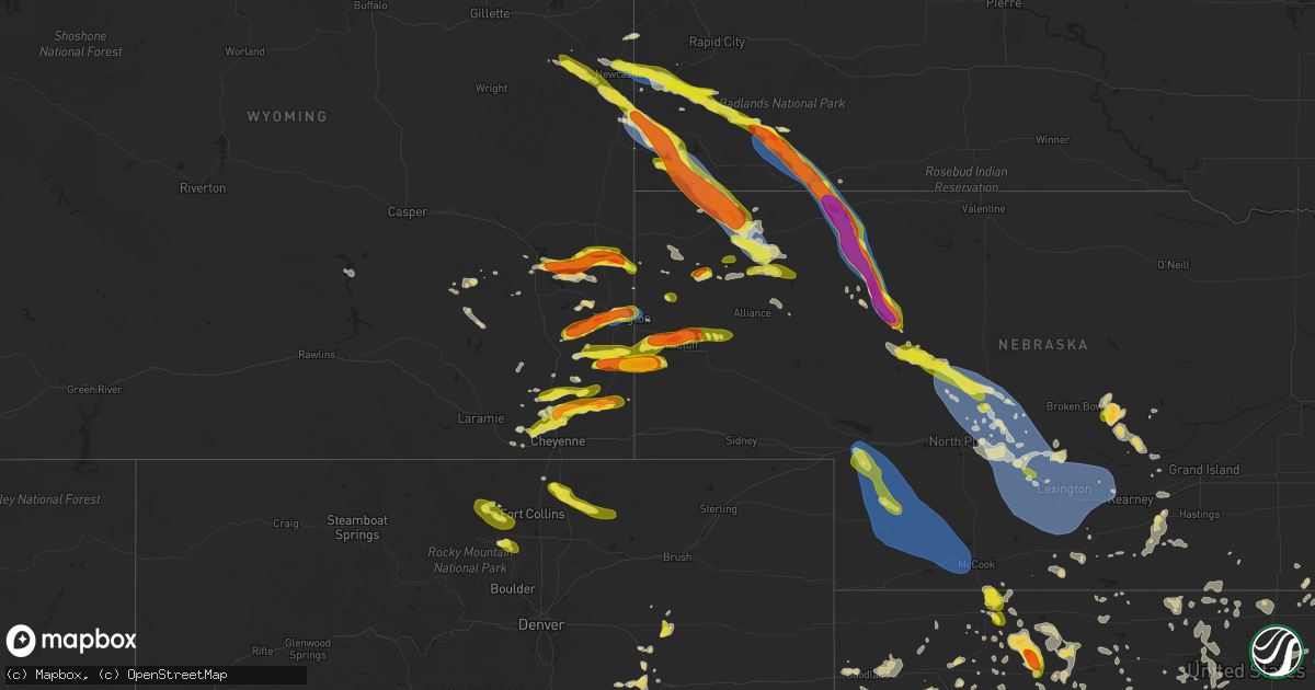
Hail Map on June 29, 2025
Get this storm
June 29 map
$229
one time, instant access
Download today. No call, no setup
Keep the $229
Bought the map and want the full workflow? Apply the entire $229 to a subscription within 7 days. None of it is wasted.
Every map, not just this one
This buys you this map. Subscription and you get every map we run, in the markets you choose from a few cities to whole states to nationwide. Plus real-time alerts the moment a storm fires.
Contact data
Name, contact info, occupancy, even credit band for addresses in the footprint. You go from where it hit to who to call.
Become the source they trust
Unlimited branding weather history reports on demand. You already have the documented answer ready for the property owner, and you are the one who showed up with it.
Property data and RoofTrace estimates
Pull up any address you have got, its value and the exact code rules for that jurisdiction, straight from One Click Code. Then RoofTrace estimates the squares, pitch, and roof value, priced the way you price.
States Impacted by Hail Map on June 29, 2025
Storm reports
Oklahoma
| Date | Description |
|---|---|
| 06/29/202512:30 AM CDT | 3 inch tree limbs down... Reported from mping. |
| 06/29/202512:30 AM CDT | Delayed report of several power lines down. Time estimated from radar. |
| 06/29/202512:21 AM CDT | A local report indicates 60 MPH wind near 5 WNW Fairmont |
| 06/29/202512:15 AM CDT | A local report indicates 60 MPH wind near 1 WSW Lahoma |
| 06/28/202510:35 PM CDT | Corrects previous tstm wnd gst report from 3 sw skedee. |
| 06/28/20259:30 PM CDT | Oklahoma mesonet newkirk station. |
| 06/28/20257:53 PM CDT | Pic of golf ball hail next to a ruler relayed via social media. |
| 06/28/20257:50 PM CDT | Power pole down. Time estimated via radar. |
Colorado
| Date | Description |
|---|---|
| 06/29/20255:25 PM CDT | A local report indicates 1.00 inch wind near 4 WSW Carter Lake |
| 06/29/20254:30 PM CDT | A local report indicates 1.00 inch wind near 2 NNE Nunn |
| 06/29/20254:00 PM CDT | A local report indicates 1.00 inch wind near 3 E Pennock Pass |
| 06/28/202510:52 PM CDT | Mesonet station up694 2.2 e arapahoe |
| 06/28/202510:39 PM CDT | Site kemp well service reports 61 mph wind gust. |
| 06/28/202510:20 PM CDT | Site up723 reports 59 mph wind gust. |
| 06/28/202510:14 PM CDT | Site co068 reports 60 mph wind gust. |
| 06/28/20259:08 PM CDT | Site up695 reports 58 mph wind gust. |
| 06/28/20258:56 PM CDT | A local report indicates 61 MPH wind near Hugo |
Missouri
| Date | Description |
|---|---|
| 06/29/20255:42 PM CDT | Weather station at emergency managment measured a 68mph wind gust. |
| 06/29/20255:42 PM CDT | Large branch fell on house. Time based on radar estimated. |
| 06/29/20255:37 PM CDT | *** 4 inj *** four injured by flying debris at the thunder ridge nature arena. |
| 06/29/20255:36 PM CDT | 8-10 in diameter tree top broke... And landed near a camper. |
| 06/29/20255:30 PM CDT | Tree tops broken off in the lampe area. |
| 06/29/20255:30 PM CDT | 6 to 8 inch tree branch broke off. Time based on radar. |
| 06/29/20255:25 PM CDT | Mesonet station fw9611 branson. |
| 06/29/20255:24 PM CDT | 8 inch tree limb down. Time based on radar. |
| 06/29/20255:18 PM CDT | Tree down on road. |
| 06/29/20255:15 PM CDT | 60-70 mph winds downed trees and power lines. Four boats were capsized on table rock lake. |
| 06/29/20255:09 PM CDT | Tree uprooted and another tree split on henderson road. |
| 06/29/20255:09 PM CDT | Tree branch down on hannah drive. |
| 06/29/20255:09 PM CDT | Tree split on jennifer lane in rogersville. |
| 06/29/20255:09 PM CDT | Tree down on selmore road blocking the road. |
| 06/29/20255:06 PM CDT | Tree down across the road. |
| 06/29/20255:05 PM CDT | Lots of tree limbs down a few trees toppled... And power outages. Anemometer and outdoor weather station. |
| 06/29/20255:05 PM CDT | Tree down in the eastbound lane. |
| 06/29/20255:04 PM CDT | Tree down on parch corn road. |
| 06/29/20255:04 PM CDT | Tree down on the road. |
| 06/29/20255:04 PM CDT | Tree blocking the road on bain st. |
| 06/29/20255:04 PM CDT | Tree down on warren st blocking road. |
| 06/29/20255:00 PM CDT | Pictures of a fireworks tent blown over. |
| 06/29/20255:00 PM CDT | Tree down blocking roadway. |
| 06/29/20255:00 PM CDT | Some trees down and partial road blockage. |
| 06/29/20255:00 PM CDT | Trees down at golf course. |
| 06/29/20255:00 PM CDT | Tree down on tennis st. |
| 06/29/20254:59 PM CDT | Tree fell on mobile home no one is injured. |
| 06/29/20254:58 PM CDT | Large tree uprooted and large branches fell on house. Via social media. Time based on radar estimate. |
| 06/29/20254:56 PM CDT | Large tree blocking road. Time based on radar. |
| 06/29/20254:55 PM CDT | 6 inch tree limbs down. Time based on radar estimate. |
| 06/29/20254:55 PM CDT | 1 mile south of cox south hospital has a significant sized tree limb on layfayette court. |
| 06/29/20254:55 PM CDT | Tree down on powerline. |
| 06/29/20254:55 PM CDT | Power lines are down across the road... And a tree down. Time based on radar estimate. |
| 06/29/20254:54 PM CDT | Tree across the road way blocking the road. |
| 06/29/20254:54 PM CDT | Tree blocking part of road on s sunrise in a couple of locations... Traffic lights out in several locations along kansas expressway. Power lines down on scenic... Acros |
| 06/29/20254:54 PM CDT | Trees down. |
| 06/29/20254:54 PM CDT | Trees down on power lines. Time based on radar estimate. |
| 06/29/20254:54 PM CDT | Large tree down on road blocking traffic. |
| 06/29/20254:54 PM CDT | 12 inch limbs down. |
| 06/29/20254:53 PM CDT | Branches blown off... Roof damage. Time based on radar. |
| 06/29/20254:53 PM CDT | Tree blocking roadway. |
| 06/29/20254:53 PM CDT | Tree fell on roadway blocking both lanes. |
| 06/29/20254:53 PM CDT | Large tree broke near the base. Older tree. Time based on radar. Shingles blown off of pawn shop off battlefield and kansas. |
| 06/29/20254:50 PM CDT | 30 diameter elm tree completely uprooted. Location: battlefield... Mo near w weaver rd & ridgecrest dr. |
| 06/29/20254:48 PM CDT | 10 inch limb on house. Across the street there are two uprooted trees on pickup and garage. |
| 06/29/20254:45 PM CDT | Tree branch fell on fence cause damage. |
| 06/29/20254:45 PM CDT | Tree on lines. |
| 06/29/20254:45 PM CDT | Mocomagnet |
| 06/29/20254:45 PM CDT | Large branch on house. |
| 06/29/20254:45 PM CDT | 24 inch tree down. |
| 06/29/20254:43 PM CDT | Large tree down blocking both lanes of west battlefield. |
| 06/29/20254:42 PM CDT | 2 power poles snapped... And partially leaning into the road. |
| 06/29/20254:42 PM CDT | Line pole down on roadway. Time based on radar estimate. |
| 06/29/20254:42 PM CDT | Corrects time of previous tstm wnd dmg report from 1 sw republic. Large branch fell on house. Time based on radar estimated. |
| 06/29/20254:42 PM CDT | Extensive tree damage on the north side of republic. Estimated 40 percent of the city without power. Time estimated from radar. |
| 06/29/20254:42 PM CDT | Branches and power lines down. Time based on radar. |
| 06/29/20254:42 PM CDT | Whole intersection is blocked by a large tree in the road. |
| 06/29/20254:40 PM CDT | Tree down on powerline. |
| 06/29/20254:40 PM CDT | Two to three large trees down. |
| 06/29/20254:39 PM CDT | Tree down blocking road blocking oak st. |
| 06/29/20254:36 PM CDT | Up to 16 inch diameter trees down mm 68 1/2 on i44. |
| 06/29/20254:36 PM CDT | A local report indicates 63 MPH wind near 5 SSE Willard |
| 06/29/20254:36 PM CDT | Large tree fell on power line. |
| 06/29/20254:36 PM CDT | A power pole was broken. |
| 06/29/20254:34 PM CDT | Tree completely blocking road. |
| 06/29/20254:30 PM CDT | Tree hanging over roadway. |
| 06/29/20254:30 PM CDT | Trees and power lines down across roads... Tree down on house... Tree down on car in ash grove. |
| 06/29/20254:30 PM CDT | Major number of trees uprooted and neighbors old barn leveled. |
| 06/29/20254:25 PM CDT | A tree was down due to thunderstorm winds. |
| 06/29/20254:20 PM CDT | Tree fell on powerline. |
| 06/29/20254:20 PM CDT | State highway mm closed due to trees and powerlines across roadway. |
| 06/29/20254:20 PM CDT | Powerlines down in the area. |
| 06/29/20254:20 PM CDT | 6-8 inch branches down in lawrence county halltown area. Via fire dep. |
| 06/29/20254:18 PM CDT | Powerlines down in everton. |
| 06/29/20254:09 PM CDT | Trees fell on powerlines and caused fire near house. |
| 06/29/20254:03 PM CDT | Trees down. |
| 06/29/20254:00 PM CDT | A powerline was down due to thunderstorm winds. |
| 06/29/20254:00 PM CDT | Power pole snapped in greenfield on broad st. |
| 06/29/20254:00 PM CDT | Trees down off state highway z. |
| 06/29/20254:00 PM CDT | Powerlines down on house. |
| 06/29/20254:00 PM CDT | Trees and powerlines down over roadway. |
| 06/29/20254:00 PM CDT | Tree down on powerlines. |
| 06/29/20254:00 PM CDT | In greenfield... Mo 6-8 inch to entire trees uprooted... A metal roof with 1/3 of roof gone. About from well street along 39 hwy south and back east. |
| 06/29/20253:53 PM CDT | Powerlines down. |
| 06/29/20253:53 PM CDT | Large tree down. |
| 06/29/20253:51 PM CDT | Tree just took out powerline in yard... Both down. |
| 06/29/20253:42 PM CDT | Trees down near highway e and highway d. |
| 06/29/20253:00 PM CDT | Multiple trees down and roads blocked in nevada... Mo. |
| 06/29/20251:35 PM CDT | Social media report of downed wires near route f. Time estimated from radar. |
| 06/29/20251:25 PM CDT | Social media report of downed power poles and power lines on route 18 near county road 6001. Time estimated from radar. |
| 06/29/20251:22 PM CDT | Social media reports of downed wires and power outages near route aa. Time estimated from radar. |
Illinois
| Date | Description |
|---|---|
| 06/29/20253:16 PM CDT | Updates previous tstm wnd dmg report from sibley. Photos shared show corn blown down. Numerous large tree limbs blown down. Photo shows soffit damage to a house. |
| 06/29/20253:16 PM CDT | Updates previous tstm wnd dmg report from sibley. Photos shared show corn blown down. Numerous large tree limbs blown down. Photo shows so |
| 06/29/20253:16 PM CDT | Photos shared show corn blown down and a large tree limb blown down. |
| 06/28/20258:50 PM CDT | During the evening of june 29... A microburst impacted a portion of libertyville. A large tree fell onto a townhouse at 855 county club drive... Rendering it uninhabita |
| 06/28/20258:16 PM CDT | Weatherbug station measured wind gust to 64 mph. |
| 06/28/20258:00 PM CDT | Measured gust to 51 knots at pwk. |
| 06/28/20258:00 PM CDT | Measured gust |
Kansas
| Date | Description |
|---|---|
| 06/29/20256:59 PM CDT | A local report indicates 1.25 inch wind near Augusta |
| 06/29/20251:22 PM CDT | Multiple social media reports of limbs down in the linn valley area. Time estimated from radar. |
| 06/29/202512:50 PM CDT | Delayed report. Social media report of a downed tree at a residence. Time estimated from radar. |
| 06/29/202512:48 PM CDT | Delayed report. Multiple social media reports of downed trees in the bucyrus area. Time estimated from radar. |
| 06/29/202510:50 AM CDT | Raws station qnrk1 stafford. |
| 06/29/20254:46 AM CDT | Bunkerhill mesonet measured 72 mph. |
| 06/29/20254:40 AM CDT | (ic |
| 06/29/20254:40 AM CDT | A local report indicates 59 MPH wind near Russell Airport |
| 06/29/20253:13 AM CDT | Site six toes feed & seed reports 58 mph wind gust. |
| 06/29/20253:02 AM CDT | Site khlc reports 60 mph wind gust. |
| 06/29/20252:55 AM CDT | Site khlc reports 59 mph wind gust. |
| 06/28/202510:51 PM CDT | Social media post. |
| 06/28/20259:05 PM CDT | Asos station kwld strother field airport. |
| 06/28/20259:01 PM CDT | Kwld measured 68 mph. |
| 06/28/20259:00 PM CDT | A local report indicates 60 MPH wind near Arkansas City |
| 06/28/20258:58 PM CDT | Asos station kwld strother field airport. |
| 06/28/20258:55 PM CDT | Four-inch diameter limbs blown down... Estimating at least 60 mph. |
| 06/28/20258:52 PM CDT | Asos station kwld strother field airport. Gusted to 60 mph at 8:54pm as well. |
| 06/28/20258:45 PM CDT | Report relayed by em. |
| 06/28/20257:49 PM CDT | Courtesy of kwch. |
| 06/28/20257:45 PM CDT | Delayed report. Courtesy of ksu mesonet. |
| 06/28/20257:41 PM CDT | A local report indicates 60 MPH wind near Severy |
| 06/28/20257:23 PM CDT | A local report indicates 1.50 inch wind near 2 S Derby |
Delaware
| Date | Description |
|---|---|
| 06/29/20255:29 PM CDT | Large tree split and snapped along woodland ferry road right next to the laurel little league fields. Time estimated from radar. |
| 06/29/20255:29 PM CDT | Multiple tree branches snapped on holly branch drive and road 492a. |
| 06/29/20255:14 PM CDT | Corrects previous tstm wnd gst report from bethel. Measured wind gust of 58 mph with tree limbs down and a portion of metal roofing was peeled off a house nearby in bet |
| 06/29/20255:14 PM CDT | Measured wind gust of 58 mph with tree limbs down nearby in bethel from a microburst. Photo of tree limb down and video showing onset of microburst and severe winds pro |
Wisconsin
| Date | Description |
|---|---|
| 06/29/20253:20 PM CDT | Powerlines down. |
| 06/29/20253:18 PM CDT | Wind damage to power transformer causing the power to be knocked out. Blown transformer seen on video via social media. |
| 06/29/20252:46 PM CDT | Uprooted tree. Time estimated by radar. |
| 06/29/20251:48 PM CDT | Damaging wind gust snapped a large maple tree onto a shed. |
| 06/29/20251:42 PM CDT | Estimated 50 to 60 mph wind gusts. |
| 06/29/20251:34 PM CDT | Corrects previous tstm wnd dmg report from scandinavia. Several trees down. Time estimated from radar. |
| 06/29/20251:27 PM CDT | Time estimated by radar. |
| 06/29/20251:11 PM CDT | Several trees down. Time estimated from radar. |
| 06/29/20251:09 PM CDT | Relayed via wsaw-tv. |
| 06/29/20251:00 PM CDT | Report via social media. |
| 06/28/20259:23 PM CDT | Milwaukee fire department reports that an empty plane was flipped from thunderstorm wind gusts at milwaukee lawrence-timmerman airport. |
| 06/28/20259:23 PM CDT | Milwaukee fire department reports that an empty plane was flipped from thunderstorm wind gusts at milwaukee lawrence-timmerman a |
| 06/28/20259:20 PM CDT | Off-duty nws employee reports large tree and branch down near silver spring drive and interstate 41. |
| 06/28/20258:49 PM CDT | Broadcast media relays report of tree down near 97th and carmen near butler. |
| 06/28/20258:44 PM CDT | Photo shared on social media of large tree trunk split near 106th and congress in northern wauwautosa. |
| 06/28/20257:26 PM CDT | Tree down relayed from social media. Time estimated from radar. |
| 06/28/20257:26 PM CDT | Awos station kmwc milwaukee lawrence-timmerman airport. |
Texas
| Date | Description |
|---|---|
| 06/28/20257:07 PM CDT | Reports of downed powerlines along highway 62. |
Arkansas
| Date | Description |
|---|---|
| 06/29/20256:20 PM CDT | Tree down on vaughn road in sw part of centerton blocking the roadway. Exact location estimated. Time estimated via radar. |
Nebraska
| Date | Description |
|---|---|
| 06/29/20256:49 PM CDT | A local report indicates 2.30 inch wind near 14 WSW Gering |
| 06/29/20256:35 PM CDT | A local report indicates 1.75 inch wind near 13 S Lyman |
| 06/29/20256:35 PM CDT | Measured 2 inch hail at the intersection of county road x and county road 6. |
| 06/29/20256:31 PM CDT | A local report indicates 1.50 inch wind near 11 NNE La Grange |
| 06/29/20253:20 AM CDT | Very tree limbs down causing damage to homes and vehicles. Photos via em. Time estimated fro |
| 06/29/20253:20 AM CDT | Very tree limbs down causing damage to homes and vehicles. Photos via em. Time estimated from radar. |
| 06/29/20253:18 AM CDT | Unofficial personal weather station |
| 06/29/20253:18 AM CDT | Unofficial personal weather station. |
| 06/29/20253:16 AM CDT | A local report indicates 60 MPH wind near Kearney |
| 06/29/20253:15 AM CDT | On the backside of storms. |
| 06/29/20252:58 AM CDT | Unofficial personal weather station. |
| 06/29/20252:51 AM CDT | Unofficial personal weather station. |
| 06/29/20252:47 AM CDT | Unofficial personal weather station. |
| 06/29/20252:44 AM CDT | Unofficial personal weather station. |
| 06/29/20252:30 AM CDT | Unofficial personal weather station. |
| 06/29/20252:15 AM CDT | A local report indicates 67 MPH wind near Lexington Airport |
| 06/29/20252:05 AM CDT | Several miles of power poles and line down due to high winds. |
| 06/29/20252:00 AM CDT | Unofficial personal weather station. |
| 06/29/20251:44 AM CDT | Quarter size hail. |
| 06/29/20251:30 AM CDT | A local report indicates 64 MPH wind near 8 SW Callaway |
| 06/29/202512:53 AM CDT | A local report indicates 59 MPH wind near Imperial |
| 06/29/202512:40 AM CDT | Also reported hail up to 1 inch diameter. |
| 06/29/202512:40 AM CDT | A local report indicates 1.00 inch wind near 6 S Stapleton |
| 06/29/202512:15 AM CDT | A local report indicates 58 MPH wind near 1 E Grant |
| 06/28/20259:15 PM CDT | Report via social media. Time estimated from radar. |
| 06/28/20258:12 PM CDT | A local report indicates 66 MPH wind near 3 SW Chadron State Park |
| 06/28/20257:52 PM CDT | Pea to quarter sized hail on the north side of lake minatare. Time estimated via radar. |
| 06/28/20257:50 PM CDT | Asos station kcdr chadron airport - cdr. |
| 06/28/20257:44 PM CDT | A local report indicates 1.50 inch wind near 5 W Scottsbluff |
| 06/28/20257:44 PM CDT | A local report indicates 1.50 inch wind near 5 W Chadron |
| 06/28/20257:36 PM CDT | Report from mping: quarter |
| 06/28/20257:35 PM CDT | Estimated 70 mph winds. Some trees blown over. |
| 06/28/20257:33 PM CDT | Report from mping: quarter |
| 06/28/20257:33 PM CDT | A local report indicates 1.75 inch wind near Scottsbluff |
| 06/28/20257:30 PM CDT | Report via social media. |
| 06/28/20257:27 PM CDT | 8 inch tree trunk snapped. |
| 06/28/20257:27 PM CDT | At least 10 large trees blown over at the scottsbluff country club. Several homes had broken windows due to wind driven hail. |
| 06/28/20257:18 PM CDT | A local report indicates 1.25 inch wind near 4 S Mitchell |
| 06/28/20257:10 PM CDT | A local report indicates 1.00 inch wind near 4.5 SSW Mitchell |
Georgia
| Date | Description |
|---|---|
| 06/29/20254:40 PM CDT | Trees reported down across the road on hwy 52 e near the intersection with roy rd. |
South Dakota
| Date | Description |
|---|---|
| 06/29/20256:25 PM CDT | A local report indicates 1.25 inch wind near Edgemont |
| 06/29/20256:22 PM CDT | Nickel to quarter size hail. Ongoing during call around 527 pm. |
| 06/29/20256:12 PM CDT | A local report indicates 1.00 inch wind near 1 W Manderson |
| 06/29/20256:12 PM CDT | A local report indicates 60 MPH wind near 1 W Manderson |
| 06/29/20256:00 PM CDT | A local report indicates 60 MPH wind near 14 NNW Edgemont |
| 06/29/20255:40 PM CDT | A local report indicates 1.75 inch wind near 11 SW Rockyford |
| 06/29/20254:25 PM CDT | A local report indicates 1.00 inch wind near 14 ESE Custer |
| 06/29/20253:52 PM CDT | Hail covered the ground. |
| 06/29/20257:35 AM CDT | Photos show several stones of quarter to at least half dollar size |
| 06/29/20257:35 AM CDT | Largest hail about the size of a quarter. Most hail was smaller... Pea to nickel |
| 06/28/20259:16 PM CDT | Mesonet station 175 mellette |
| 06/28/20258:40 PM CDT | Mesonet station 315 cresbard |
| 06/28/20257:20 PM CDT | A local report indicates 1.00 inch wind near 13 E Ardmore |
| 06/28/20257:12 PM CDT | A local report indicates 60 MPH wind near 11 SW Oelrichs |
Virginia
| Date | Description |
|---|---|
| 06/29/20255:00 PM CDT | Delayed report: picture seen on social media of a large part of a tree down near rustburg... Va. |
Wyoming
| Date | Description |
|---|---|
| 06/29/20256:05 PM CDT | Half dollar sized hail reported just south of the intersection of us85 and wy313. |
| 06/29/20255:25 PM CDT | A local report indicates 1.75 inch wind near 3 WSW Gun Barrel |
| 06/29/20255:13 PM CDT | A local report indicates 1.00 inch wind near 12 SSW Newcastle |
| 06/29/20254:25 PM CDT | A local report indicates 1.50 inch wind near 5 SSE Whitaker |
| 06/29/20254:21 PM CDT | Report from mping: half dollar |
| 06/29/20254:20 PM CDT | Report from mping: quarter |
| 06/29/20254:08 PM CDT | Mesonet station wy22 2.7 nw arlington |
| 06/29/20253:59 PM CDT | A local report indicates 1.00 inch wind near 6 NW Warren Af Base |
| 06/29/20253:00 PM CDT | A local report indicates 60 MPH wind near 3 NNE Newcastle |
| 06/28/20258:11 PM CDT | A local report indicates 1.75 inch wind near 8 E Jay Em |
| 06/28/20257:58 PM CDT | Emergency manager found hail of quarter sized still on the side of the highway 85 at mp 129 at 8:12pm. Time of hail falling was estimated based on radar. |
| 06/28/20257:31 PM CDT | Large trees uprooted. |
| 06/28/20257:30 PM CDT | Estimated wind gust. |
| 06/28/20257:18 PM CDT | A local report indicates 1.25 inch wind near 4 S Lingle |
| 06/28/20257:17 PM CDT | A local report indicates 1.75 inch wind near 6 SSW Lingle |
| 06/28/20257:13 PM CDT | Road covered in quarter sized hail 3 inches deep. |
New Jersey
| Date | Description |
|---|---|
| 06/29/20255:50 PM CDT | Atlantic city international airport asos station measured a 60 mph wind gust at 6:50 pm. |
New Mexico
| Date | Description |
|---|---|
| 06/28/20257:40 PM CDT | Mesonet station wsm07 wsmr frequency. |
| 06/28/20257:37 PM CDT | Awos station khmn holloman afb awos. |
| 06/28/20257:20 PM CDT | Mesonet station wsm51 malone. |
Maryland
| Date | Description |
|---|---|
| 06/29/20254:30 PM CDT | Large tree limbs snapped in dundalk. |
| 06/29/20254:26 PM CDT | Quarter size hail was reported near dundalk. |
| 06/29/20254:25 PM CDT | Numerous trees and wires blew down in and around the dundalk area. |
| 06/29/20254:21 PM CDT | There was a report of large tree limbs blown down near dundalk. |
Alabama
| Date | Description |
|---|---|
| 06/29/202511:55 AM CDT | A tree was knocked down at 3609 garth road blocking the roadway completely. Time estimated by radar. |
Cities Impacted by Hail Map on June 29, 2025
- Custer, SD
- Columbia, PA
- Mount Joy, PA
- Mountville, PA
- Lancaster, PA
- Burchard, NE
- Baileyville, KS
- Steinauer, NE
- Hiawatha, KS
- Robinson, KS
- Horton, KS
- Troy, KS
- Pawnee City, NE
- Hermosa, SD
- Fairburn, SD
- Odell, NE
- Diller, NE
- Falls City, NE
- Villisca, IA
- Nodaway, IA
- New Market, IA
- Bedford, IA
- Blockton, IA
- Gravity, IA
- Sharpsburg, IA
- Grant City, MO
- Sheridan, MO
- Dearborn, MO
- Gilman City, MO
- Agency, MO
- Aurora, KS
- Concordia, KS
- Clyde, KS
- Faucett, MO
- De Kalb, MO
- Saint Joseph, MO
- Spickard, MO
- Clifton, KS
- Morganville, KS
- Clay Center, KS
- Topeka, KS
- Auburn, KS
- Tecumseh, KS
- Wakarusa, KS
- Berryton, KS
- Lecompton, KS
- Lawrence, KS
- Elmer, MO
- La Plata, MO
- New Boston, MO
- Ethel, MO
- Eudora, KS
- Kirksville, MO
- Centre, AL
- Le Roy, KS
- Burlington, KS
- Waverly, KS
- Westphalia, KS
- Wisconsin Rapids, WI
- Mound City, KS
- Iola, WI
- Blue Mound, KS
- Mapleton, KS
- Amherst, WI
- Iola, KS
- Clintonville, WI
- Bear Creek, WI
- Arkdale, WI
- Necedah, WI
- Pulaski, WI
- Bonduel, WI
- Scandinavia, WI
- Waupaca, WI
- Prescott, KS
- Marion, WI
- Tigerton, WI
- Toronto, KS
- Hancock, WI
- Brimson, MN
- Pleasanton, KS
- Fulton, KS
- Two Harbors, MN
- Norwalk, WI
- Fort Scott, KS
- Ogdensburg, WI
- Manawa, WI
- Caledonia, MN
- Yates Center, KS
- Redfield, KS
- Plainfield, WI
- Hume, MO
- Richards, MO
- Newcastle, WY
- Humboldt, KS
- Chanute, KS
- Piqua, KS
- New London, WI
- Benedict, KS
- Buffalo, KS
- Shiocton, WI
- Krakow, WI
- Marathon, TX
- Almond, WI
- Nevada, MO
- Sobieski, WI
- Ochopee, FL
- Pueblo, CO
- Black Creek, WI
- Hill City, SD
- Larsen, WI
- Fremont, WI
- Sparta, WI
- Soldiers Grove, WI
- Readstown, WI
- Sibley, IL
- Strawn, IL
- Forrest, IL
- Abrams, WI
- Seymour, WI
- Cashton, WI
- Westby, WI
- Weyauwega, WI
- Little Suamico, WI
- Lamar, MO
- Viroqua, WI
- Granite Canon, WY
- Waukon, IA
- Cheyenne, WY
- Harpersville, AL
- Fort Stockton, TX
- Columbiana, AL
- Bellvue, CO
- Ontario, WI
- Hillsboro, WI
- La Farge, WI
- Dorchester, IA
- Green Bay, WI
- Liberal, MO
- Wilsonville, AL
- Beulah, WY
- Spearfish, SD
- New Albin, IA
- Lockwood, MO
- Jerico Springs, MO
- Golden City, MO
- Whitewood, SD
- Drake, CO
- Glen Haven, CO
- Rosedale, MD
- Essex, MD
- Shelby, AL
- Middle River, MD
- Greenfield, MO
- Upton, WY
- Carr, CO
- Marion, AL
- Abernathy, TX
- Richland Center, WI
- Centreville, AL
- Everton, MO
- Baltimore, MD
- South Greenfield, MO
- Nunn, CO
- Pierce, CO
- Loveland, CO
- Caulfield, MO
- Dundalk, MD
- Palm City, FL
- Rockford, AL
- Kellyton, AL
- Granby, MO
- Walnut Grove, MO
- Ash Grove, MO
- Willard, MO
- Springfield, MO
- Strafford, MO
- Fair Grove, MO
- North Freedom, WI
- Loganville, WI
- Boston, GA
- Estes Park, CO
- Lyons, CO
- Clanton, AL
- Wellington, CO
- Bois D Arc, MO
- Mount Vernon, MO
- Crane, MO
- Spokane, MO
- Nixa, MO
- Marionville, MO
- Billings, MO
- Halltown, MO
- Republic, MO
- Highlandville, MO
- Reeds Spring, MO
- Aurora, MO
- Rogersville, MO
- Ponce De Leon, MO
- Galena, MO
- Brookline, MO
- Clever, MO
- Miller, MO
- Ozark, MO
- Fordland, MO
- Marshfield, MO
- Chestnutridge, MO
- Walnut Shade, MO
- Sparta, MO
- Ault, CO
- Meriden, WY
- Albin, WY
- Burns, WY
- Buffalo Gap, SD
- Pine Ridge, SD
- Trementina, NM
- Avondale, CO
- Fowler, CO
- Sparrows Point, MD
- Verbena, AL
- Hollister, MO
- Forsyth, MO
- Chadwick, MO
- Rockaway Beach, MO
- Cape Fair, MO
- Bruner, MO
- Oldfield, MO
- Branson, MO
- Bradleyville, MO
- Mansfield, MO
- Taneyville, MO
- Powersite, MO
- Hartville, MO
- Kirbyville, MO
- Seymour, MO
- Ava, MO
- Garrison, MO
- Berthoud, CO
- Briggsdale, CO
- Galeton, CO
- Edgemont, SD
- Edinburg, VA
- Wardensville, WV
- South West City, MO
- Noel, MO
- Ruckersville, VA
- Lagrange, WY
- Lubbock, TX
- Leroy, AL
- Ridgeway, WI
- Jackson, AL
- Juneau, WI
- Hawk Springs, WY
- Shallowater, TX
- Grenville, NM
- Folsom, NM
- Colorado Springs, CO
- Dupree, SD
- Anderson, MO
- Norwood, MO
- Theodosia, MO
- Protem, MO
- Macomb, MO
- Wasola, MO
- Squires, MO
- Noble, MO
- Cedarcreek, MO
- Zanoni, MO
- Mountain Grove, MO
- Thornfield, MO
- Gainesville, MO
- Isabella, MO
- Brixey, MO
- Kissee Mills, MO
- Drury, MO
- Rueter, MO
- Hardenville, MO
- Pontiac, MO
- Mountain Home, AR
- Oakland, AR
- Clarkridge, AR
- Yellville, AR
- Lakeview, AR
- Midway, AR
- Lead Hill, AR
- Peel, AR
- Omaha, AR
- Gassville, AR
- Cotter, AR
- Flippin, AR
- Bull Shoals, AR
- Pyatt, AR
- Harrison, AR
- Everton, AR
- Horicon, WI
- Egg Harbor Township, NJ
- Mays Landing, NJ
- Immokalee, FL
- Yoder, CO
- Tecumseh, MO
- Lyman, NE
- Harrisburg, NE
- Yoder, WY
- Batesland, SD
- Porcupine, SD
- Manderson, SD
- Wounded Knee, SD
- Hot Springs, SD
- Lance Creek, WY
- Boise City, OK
- Gering, NE
- Torrington, WY
- Kermit, TX
- Augusta, KS
- Glendo, WY
- Hartville, WY
- Wheatland, WY
- Veteran, WY
- Sardis, AL
- Kannapolis, NC
- Afton, OK
- Towanda, KS
- Piedmont, KS
- Eureka, KS
- El Dorado, KS
- Mitchell, NE
- Morrill, NE
- Scottsbluff, NE
- Valley Springs, AR
- Calico Rock, AR
- Norfork, AR
- Gilbert, AR
- Harriet, AR
- Marshall, AR
- Western Grove, AR
- Pindall, AR
- Saint Joe, AR
- Summit, AR
- Marble Falls, AR
- Hasty, AR
- Chelsea, OK
- Washington, GA
- Tignall, GA
- Rayle, GA
- Mulvane, KS
- Derby, KS
- Haysville, KS
- Nowata, OK
- Elkhart, KS
- Benton, KS
- Ontonagon, MI
- Ewen, MI
- Grove Hill, AL
- Huntersville, NC
- Agate, CO
- Gordon, NE
- Minatare, NE
- Lingle, WY
- Harrison, NE
- Jay Em, WY
- Severy, KS
- Douglass, KS
- Latham, KS
- Goodwell, OK
- Fort Morgan, CO
- Claremore, OK
- Vinita, OK
- Leon, KS
- Andover, KS
- Ramah, CO
- Oelrichs, SD
- Chadron, NE
- Whitney, NE
- Martin, SD
- Merriman, NE
- Howard, KS
- Marsland, NE
- Hemingford, NE
- Fall River, KS
- Moline, KS
- Elk Falls, KS
- Garrett, WY
- Columbia, VA
- Simla, CO
- Palmyra, WI
- Eagle, WI
- Deer Trail, CO
- Cassville, WI
- Farwell, TX
- Arlington Heights, IL
- Mount Prospect, IL
- Wheeling, IL
- Prospect Heights, IL
- Buffalo Grove, IL
- Deerfield, IL
- Lincolnshire, IL
- Des Plaines, IL
- Highland Park, IL
- Glenview, IL
- Northbrook, IL
- Keyes, OK
- Hanna, WY
- Longton, KS
- Bayard, NE
- Angora, NE
- Hay Springs, NE
- Alliance, NE
- Udall, KS
- Seneca, KS
- Beatrice, NE
- Malmo, NE
- Rose Hill, KS
- Guymon, OK
- Goochland, VA
- Atlanta, KS
- Grenola, KS
- Cambridge, KS
- Hoven, SD
- Lebanon, SD
- Gettysburg, SD
- Tolstoy, SD
- Java, SD
- Onaka, SD
- Bowdle, SD
- Roscoe, SD
- Faulkton, SD
- Seneca, SD
- Highmore, SD
- Orient, SD
- Onida, SD
- Cresbard, SD
- Ipswich, SD
- Northville, SD
- Redfield, SD
- Ashton, SD
- Rockham, SD
- Mansfield, SD
- Fort Laramie, WY
- Chugwater, WY
- Thayer, MO
- Whitman, NE
- Rushville, NE
- Rock, KS
- Winfield, KS
- Belle Plaine, KS
- Oxford, KS
- Burden, KS
- Arkansas City, KS
- Geuda Springs, KS
- Peru, KS
- Pawhuska, OK
- Chautauqua, KS
- Sedan, KS
- Cedar Vale, KS
- Dexter, KS
- Shidler, OK
- Newkirk, OK
- Maple City, KS
- Caney, KS
- Copan, OK
- Niotaze, KS
- Havana, KS
- Elk City, KS
- Limon, CO
- Texico, NM
- Dewey, OK
- Bartlesville, OK
- Wann, OK
- Delaware, OK
- Karval, CO
- Wild Horse, CO
- Kit Carson, CO
- Walsh, CO
- Hugo, CO
- Medicine Bow, WY
- Clovis, NM
- Haswell, CO
- Portales, NM
- Westport, SD
- Aberdeen, SD
- Mellette, SD
- Brentford, SD
- Warner, SD
- Hyannis, NE
- Ponca City, OK
- Burbank, OK
- Kaw City, OK
- Ochelata, OK
- Lenapah, OK
- Arriba, CO
- Stanardsville, VA
- Millersburg, MI
- Lakin, KS
- Wellington, KS
- Onaway, MI
- Woodford, VA
- Hawks, MI
- Guernsey, WY
- Johnson, KS
- Norwich, KS
- Argonia, KS
- Harper, KS
- Barnsdall, OK
- Fairfax, OK
- Wynona, OK
- Ralston, OK
- Ramona, OK
- Marland, OK
- Talala, OK
- Mullen, NE
- Douglas, WY
- Oologah, OK
- Milton, KS
- Buffalo Junction, VA
- Red Oak, VA
- Scottsburg, VA
- Danville, KS
- Caldwell, KS
- Mayfield, KS
- Cheyenne Wells, CO
- Arapahoe, CO
- Sharon Springs, KS
- San Jon, NM
- Milan, KS
- Collinsville, OK
- Pawnee, OK
- Skiatook, OK
- Hominy, OK
- Vera, OK
- Sperry, OK
- Osage, OK
- Prue, OK
- Crawford, NE
- Freeport, KS
- Lake Forest, IL
- Highwood, IL
- Bluff City, KS
- Elida, NM
- Milwaukee, WI
- Menomonee Falls, WI
- Brookfield, WI
- Butler, WI
- Elm Grove, WI
- Mequon, WI
- Tryon, NE
- Ellsworth, NE
- Braman, OK
- Weskan, KS
- Medford, OK
- Conway Springs, KS
- Channing, TX
- Nash, OK
- Adair, OK
- Whitewater, KS
- Stapleton, NE
- Peck, KS
- Newton, KS
- Tribune, KS
- Venango, NE
- Brule, NE
- Pryor, OK
- Catoosa, OK
- Wakita, OK
- Ogallala, NE
- Grant, NE
- Madrid, NE
- South Haven, KS
- Nardin, OK
- Lamont, OK
- Blackwell, OK
- Deer Creek, OK
- Carrier, OK
- Kremlin, OK
- Hunter, OK
- Tonkawa, OK
- Enid, OK
- Pond Creek, OK
- Red Rock, OK
- Covington, OK
- Billings, OK
- Garber, OK
- Fairmont, OK
- Perry, OK
- Wallace, KS
- Burlington, CO
- Fredonia, KS
- Inola, OK
- Oxford, NE
- Ford, VA
- Floyd, NM
- Oberlin, KS
- Danbury, NE
- Imperial, NE
- Wauneta, NE
- Elsie, NE
- Wallace, NE
- Clearwater, KS
- Kyle, SD
- Arcola, MO
- Pratt, KS
- S Coffeyville, OK
- Beaver City, NE
- Goodland, KS
- Burrton, KS
- Maxwell, NE
- North Platte, NE
- Arnold, NE
- Brady, NE
- Enders, NE
- Hayes Center, NE
- Halstead, KS
- Edison, NE
- Wichita, KS
- Paragould, AR
- Dighton, KS
- Peabody, KS
- McCook, NE
- Ulysses, KS
- Sedgwick, KS
- Stafford, KS
- St John, KS
- Hudson, KS
- Nickerson, KS
- Abbyville, KS
- Raymond, KS
- Sylvia, KS
- Alden, KS
- Plevna, KS
- Sterling, KS
- Alma, NE
- Winona, KS
- Wilcox, NE
- Kanorado, KS
- Isabel, KS
- Norcatur, KS
- Mount Hope, KS
- Haviland, KS
- Comstock, NE
- Manchester, OK
- Gothenburg, NE
- Utica, KS
- Sawyer, KS
- Callaway, NE
- Elwood, NE
- Moorefield, NE
- Willow Island, NE
- Cozad, NE
- Lexington, NE
- Eustis, NE
- Farnam, NE
- Palisade, NE
- Benkelman, NE
- Culbertson, NE
- Stratton, NE
- Stillwater, OK
- Hennessey, OK
- Lucien, OK
- Marshall, OK
- Bison, OK
- Waukomis, OK
- Douglas, OK
- Mulhall, OK
- Crescent, OK
- Dover, OK
- Coyle, OK
- Orlando, OK
- Guthrie, OK
- Drummond, OK
- Oconto, NE
- Potwin, KS
- Elbing, KS
- Burns, KS
- Arcadia, NE
- Westerville, NE
- Upland, NE
- Hildreth, NE
- Minden, NE
- Holdrege, NE
- Norton, KS
- Dresden, KS
- Jennings, KS
- Clayton, KS
- Edson, KS
- Monument, KS
- Kingman, KS
- Colby, KS
- Ansley, NE
- Campbell, NE
- Eddyville, NE
- Moundridge, KS
- Colwich, KS
- Wilmore, KS
- Bladen, NE
- Holstein, NE
- Cheney, KS
- Murdock, KS
- Mason City, NE
- Arapahoe, NE
- Trenton, NE
- Maywood, NE
- Ellinwood, KS
- Chase, KS
- Lenora, KS
- Windom, KS
- Selden, KS
- Ashton, NE
- Heartwell, NE
- Atwood, KS
- Morland, KS
- Andale, KS
- Medicine Lodge, KS
- Brewster, KS
- Sumner, NE
- Smithfield, NE
- Bertrand, NE
- Overton, NE
- Loomis, NE
- Hill City, KS
- Litchfield, NE
- Mcpherson, KS
- Hillsboro, KS
- Rexford, KS
- Hoxie, KS
- Marquette, KS
- Bogue, KS
- Hoisington, KS
- Miller, NE
- Riverdale, NE
- Amherst, NE
- Kearney, NE
- Elm Creek, NE
- Odessa, NE
- Penokee, KS
- Phillipsburg, KS
- Nelson, NE
- Russell, KS
- Oakley, KS
- Levant, KS
- Gem, KS
- Loup City, NE
- Agra, KS
- Lebanon, KS
- Smith Center, KS
- Guide Rock, NE
- Republican City, NE
- Oak, NE
- Superior, NE
- Kensington, KS
- Kenesaw, NE
- Wilson, KS
- Ravenna, NE
- Hazard, NE
- Logan, KS
- Stockton, KS
- Grinnell, KS
- Ellsworth, KS
- Grainfield, KS
- Burr Oak, KS
- Mankato, KS
- Quinter, KS
- Bridgeton, NJ
- Palco, KS
- Buffalo, MO
- Louisburg, MO
- Gibbon, NE
- Urbana, MO
- Sun City, KS
- Plainville, KS
- Gilead, NE
- Esbon, KS
- Wood River, NE
- Shelton, NE
- Hebron, NE
- Gaylord, KS
- Fairbury, NE
- Reynolds, NE
- Natoma, KS
- Woodston, KS
- Webber, KS
- Formoso, KS
- Courtland, KS
- Alton, KS
- Victoria, KS
- Scandia, KS
- Belleville, KS
- Osborne, KS
- Paradise, KS
- Glen Elder, KS
- Gorham, KS
- Waldo, KS
- Palmer, KS
- Jewell, KS
- Washington, KS
- Narka, KS
- Haddam, KS
- Downs, KS
- Linn, KS
- Beloit, KS
- Barnes, KS
- Randolph, KS
- Lucas, KS
- Morrowville, KS
- Mahaska, KS
- Hunter, KS
- Tipton, KS
- Sylvan Grove, KS
- Hollenberg, KS
- Steele City, NE
- Endicott, NE
- Ellis, KS
- Hays, KS
- Catharine, KS
- Luray, KS
- Dorrance, KS
- Olmitz, KS
- Walker, KS
- Otis, KS
- Great Bend, KS
- Bunker Hill, KS
- Claflin, KS
- Pfeifer, KS
- Bison, KS
- Albert, KS
- La Crosse, KS
- Holyrood, KS
- Brookville, KS
- Geneseo, KS
- Lincoln, KS
- Bushton, KS
- Beverly, KS
- Kanopolis, KS
- Lyons, KS
- Lorraine, KS
- Greenleaf, KS
- Hanover, KS
- Frankfort, KS
- Vermillion, KS
- Matheson, CO
- Oneida, KS
- Sabetha, KS
- Atchison, KS
- Bendena, KS
- Goff, KS
- Powhattan, KS
- Fairview, KS