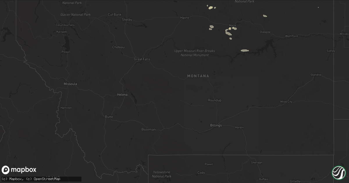
Hail Map in Montana on July 5, 2024
Get this storm
July 5 map
$229
one time, instant access
Download today. No call, no setup
Keep the $229
Bought the map and want the full workflow? Apply the entire $229 to a subscription within 7 days. None of it is wasted.
Every map, not just this one
This buys you this map. Subscription and you get every map we run, in the markets you choose from a few cities to whole states to nationwide. Plus real-time alerts the moment a storm fires.
Contact data
Name, contact info, occupancy, even credit band for addresses in the footprint. You go from where it hit to who to call.
Become the source they trust
Unlimited branding weather history reports on demand. You already have the documented answer ready for the property owner, and you are the one who showed up with it.
Property data and RoofTrace estimates
Pull up any address you have got, its value and the exact code rules for that jurisdiction, straight from One Click Code. Then RoofTrace estimates the squares, pitch, and roof value, priced the way you price.
Storm reports in Montana
Montana
| Date | Description |
|---|---|
| 07/05/20246:36 PM CDT | Glendive... Dawson community airport... Mt |
| 07/05/20245:35 PM CDT | Awos station kpo1 poplar. |
| 07/05/20245:03 PM CDT | A local report indicates 63 MPH wind near Wolf Point |
| 07/05/20244:15 PM CDT | Spotter estimated gusts to 60 mph. |
| 07/05/202412:32 PM CDT | Delayed report from trained spotter. |
| 07/04/20247:10 PM CDT | Beaver hill i-94 mt dot. |
All States Impacted by Hail Map on July 5, 2024
Cities Impacted by Hail Map on July 5, 2024
- Altamont, KS
- Oswego, KS
- Parsons, KS
- Scottsville, KY
- Glasgow, KY
- Smiths Grove, KY
- Fountain Run, KY
- Austin, KY
- Lucas, KY
- Eighty Eight, KY
- Summer Shade, KY
- Etoile, KY
- Anton, CO
- Whitleyville, TN
- Cope, CO
- Moss, TN
- Celina, TN
- Hilham, TN
- Oakland, KY
- Somerset, KY
- Macon, MS
- Pineville, KY
- Athens, TN
- Miracle, KY
- Patten, ME
- Scooba, MS
- Shuqualak, MS
- Riceville, TN
- Rocky Face, GA
- Decatur, TN
- Knoxville, TN
- Houlton, ME
- Hogeland, MT
- Harlem, MT
- Dalton, GA
- Bulan, KY
- Vest, KY
- Cross Plains, TX
- Hueysville, KY
- Prestonsburg, KY
- Gunlock, KY
- Leburn, KY
- Garrett, KY
- Mousie, KY
- Fall Branch, TN
- Kingsport, TN
- Drift, KY
- Printer, KY
- Langley, KY
- Alger, MI
- Raven, KY
- Wayland, KY
- Garner, KY
- Granbury, TX
- Cleburne, TX
- Dema, KY
- Prescott, MI
- Whittemore, MI
- Surgoinsville, TN
- Stephenville, TX
- Bluff Dale, TX
- Sterling, MI
- Hays, MT
- Fountain, MI
- Custer, MI
- Rogersville, TN
- Greeneville, TN
- Guadalupita, NM
- Tolar, TX
- Harrison, MI
- Lake, MI
- Murphy, NC
- Marion, MI
- Canton, TX
- Brasstown, NC
- Hayesville, NC
- Falmouth, MI
- Malta, MT
- West Forks, ME
- New Boston, TX
- McBain, MI
- Pineville, WV
- Ocate, NM
- Rutherfordton, NC
- Ranger, TX
- Gouldbusk, TX
- Rainbow, TX
- Lakemont, GA
- Doole, TX
- Toccoa, GA
- Glasgow, MT
- Power, MT
- Mora, NM
- Rainsville, NM
- Zortman, MT
- Filion, MI
- Port Hope, MI
- Hico, TX
- Iredell, TX
- Plentywood, MT
- Smithdale, MS
- Liberty, MS
- Summit, MS
- Buena Vista, NM
- Magnolia, MS
- Newellton, LA
- Fort Peck, MT
- Tallulah, LA
- Hamburg, AR
- Gladwin, MI
- Mio, MI
- Luzerne, MI
- Sikes, LA
- Capitan, NM
- Lewiston, MI
- Las Cruces, NM
- Chocowinity, NC
- Grimesland, NC
- Sapello, NM
- Las Vegas, NM
- Beaverton, MI
- Clare, MI
- Aquilla, TX
- Waco, TX
- West, TX
- Nogales, AZ
- Livonia, LA
- Oscar, LA
- Elm Mott, TX
- Lincoln, NM
- Bastrop, LA
- Ripley, WV
- Natchitoches, LA
- Given, WV
- Kenna, WV
- Tucson, AZ
- Evans, WV
- Gay, WV
- Reedy, WV
- Montgomery, LA
- Gandeeville, WV
- Le Roy, WV
- Mart, TX
- Groesbeck, TX
- Hondo, NM
- San Patricio, NM
- Glencoe, NM
- Cimarron, NM
- Notasulga, AL
- Spencer, WV
- Tinnie, NM
- Santa Rosa, NM
- Anton Chico, NM
- Sandyville, WV
- Vaughn, NM
- Smithfield, VA
- Carrollton, VA
- Sherwood, ND
- Trinidad, CO
- Bainville, MT
- Halliday, ND
- Robeline, LA
- Auburn, AL
- Ryder, ND
- Lovelady, TX
- Mayhill, NM
- Lockwood, NY
- Waverly, NY
- Roswell, NM
- Crockett, TX
- Mescalero, NM
- Del Rio, TX
- Wing, ND
- Barton, NY
- Yeso, NM
- El Paso, TX
- Midland, GA
- Fortson, GA
- Mauk, GA
- Glenmora, LA
- Effie, LA
- Hineston, LA
- Comstock, TX
- Box Springs, GA
- Columbus, GA
- Upatoi, GA
- Weed, NM
- Cloudcroft, NM
- Pinon, NM
- Marble, NC
- Albany, GA
- Solano, NM
- Conchas Dam, NM
- Erin, NY
- Sierra Blanca, TX
- Folsom, NM
- Grenville, NM
- Springer, NM
- Wharton, NJ
- Lake Hopatcong, NJ
- Wagon Mound, NM
- Oak Ridge, NJ
- Newfoundland, NJ
- Rockaway, NJ
- Boonton, NJ
- West Milford, NJ
- Butler, NJ
- Pompton Plains, NJ
- Riverdale, NJ
- Bloomingdale, NJ
- Bard, NM
- Adrian, TX
- San Jon, NM
- Turner, MT
- Medford, WI


