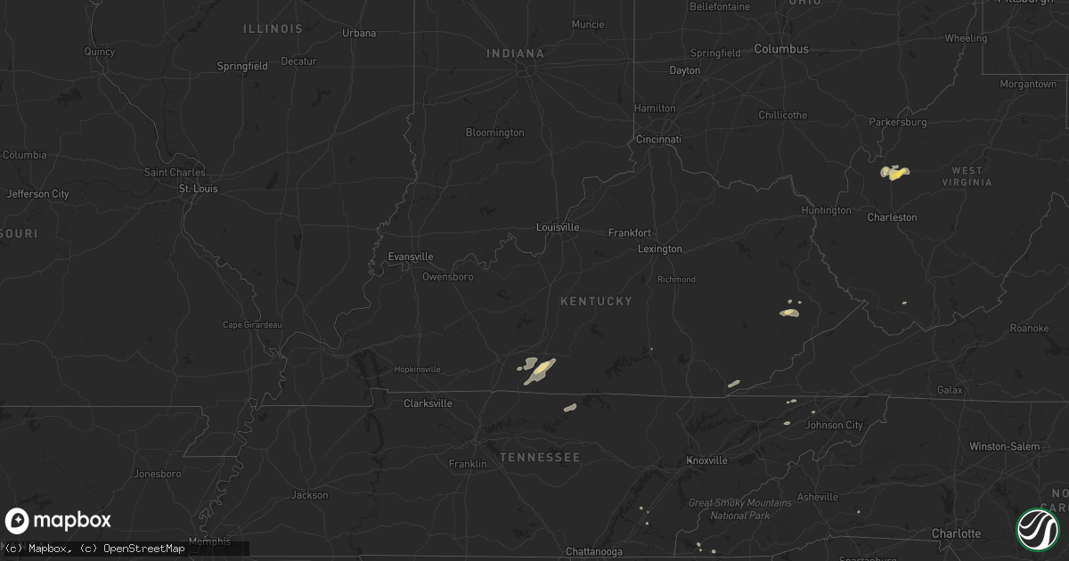
Hail Map in Kentucky on July 5, 2024
Get this storm
July 5 map
$229
one time, instant access
Download today. No call, no setup
Keep the $229
Bought the map and want the full workflow? Apply the entire $229 to a subscription within 7 days. None of it is wasted.
Every map, not just this one
This buys you this map. Subscription and you get every map we run, in the markets you choose from a few cities to whole states to nationwide. Plus real-time alerts the moment a storm fires.
Contact data
Name, contact info, occupancy, even credit band for addresses in the footprint. You go from where it hit to who to call.
Become the source they trust
Unlimited branding weather history reports on demand. You already have the documented answer ready for the property owner, and you are the one who showed up with it.
Property data and RoofTrace estimates
Pull up any address you have got, its value and the exact code rules for that jurisdiction, straight from One Click Code. Then RoofTrace estimates the squares, pitch, and roof value, priced the way you price.
Storm reports in Kentucky
Kentucky
| Date | Description |
|---|---|
| 07/05/20241:47 PM CDT | Trees down in the pinsonfork community. Time estimated via radar. |
| 07/05/20241:30 PM CDT | Trees down on ky 194 at dry branch. Time estimated via radar. |
| 07/05/20241:23 PM CDT | Trees down at indian fork rd at anderson fork. Time estimated via radar. |
| 07/05/20241:01 PM CDT | Public reported that a tree fell onto power lines at right fork penhook branch rd in the harold area. Time estimated from radar. |
| 07/05/202412:40 PM CDT | Tree down across stonecoal rd |
| 07/05/202412:02 PM CDT | A public report via social media of utility poles broken and trees down on lick branch road in the noctor community. The time of the event is radar estimated. |
| 07/05/202411:57 AM CDT | A tree was downed on riley branch blocking the roadway. This was a social media report with picture. |
| 07/05/202411:40 AM CDT | Reports of trees down in the polly hollow area of middlesboro... Including one tree on fire. Time estimated via radar. Report passed along via social media. |
| 07/05/202411:02 AM CDT | A tree was reported down in the robinson creek community near burning springs in northern clay county. The event time is radar estimated. |
| 07/05/202410:30 AM CDT | A tree was blown down on little arthur ridge road near east bernstadt. The event time is radar estimated. |
| 07/05/202410:24 AM CDT | A large limb was blown down onto us 25s blacking the roadway. |
All States Impacted by Hail Map on July 5, 2024
Cities Impacted by Hail Map on July 5, 2024
- Altamont, KS
- Oswego, KS
- Parsons, KS
- Scottsville, KY
- Glasgow, KY
- Smiths Grove, KY
- Fountain Run, KY
- Austin, KY
- Lucas, KY
- Eighty Eight, KY
- Summer Shade, KY
- Etoile, KY
- Anton, CO
- Whitleyville, TN
- Cope, CO
- Moss, TN
- Celina, TN
- Hilham, TN
- Oakland, KY
- Somerset, KY
- Macon, MS
- Pineville, KY
- Athens, TN
- Miracle, KY
- Patten, ME
- Scooba, MS
- Shuqualak, MS
- Riceville, TN
- Rocky Face, GA
- Decatur, TN
- Knoxville, TN
- Houlton, ME
- Hogeland, MT
- Harlem, MT
- Dalton, GA
- Bulan, KY
- Vest, KY
- Cross Plains, TX
- Hueysville, KY
- Prestonsburg, KY
- Gunlock, KY
- Leburn, KY
- Garrett, KY
- Mousie, KY
- Fall Branch, TN
- Kingsport, TN
- Drift, KY
- Printer, KY
- Langley, KY
- Alger, MI
- Raven, KY
- Wayland, KY
- Garner, KY
- Granbury, TX
- Cleburne, TX
- Dema, KY
- Prescott, MI
- Whittemore, MI
- Surgoinsville, TN
- Stephenville, TX
- Bluff Dale, TX
- Sterling, MI
- Hays, MT
- Fountain, MI
- Custer, MI
- Rogersville, TN
- Greeneville, TN
- Guadalupita, NM
- Tolar, TX
- Harrison, MI
- Lake, MI
- Murphy, NC
- Marion, MI
- Canton, TX
- Brasstown, NC
- Hayesville, NC
- Falmouth, MI
- Malta, MT
- West Forks, ME
- New Boston, TX
- McBain, MI
- Pineville, WV
- Ocate, NM
- Rutherfordton, NC
- Ranger, TX
- Gouldbusk, TX
- Rainbow, TX
- Lakemont, GA
- Doole, TX
- Toccoa, GA
- Glasgow, MT
- Power, MT
- Mora, NM
- Rainsville, NM
- Zortman, MT
- Filion, MI
- Port Hope, MI
- Hico, TX
- Iredell, TX
- Plentywood, MT
- Smithdale, MS
- Liberty, MS
- Summit, MS
- Buena Vista, NM
- Magnolia, MS
- Newellton, LA
- Fort Peck, MT
- Tallulah, LA
- Hamburg, AR
- Gladwin, MI
- Mio, MI
- Luzerne, MI
- Sikes, LA
- Capitan, NM
- Lewiston, MI
- Las Cruces, NM
- Chocowinity, NC
- Grimesland, NC
- Sapello, NM
- Las Vegas, NM
- Beaverton, MI
- Clare, MI
- Aquilla, TX
- Waco, TX
- West, TX
- Nogales, AZ
- Livonia, LA
- Oscar, LA
- Elm Mott, TX
- Lincoln, NM
- Bastrop, LA
- Ripley, WV
- Natchitoches, LA
- Given, WV
- Kenna, WV
- Tucson, AZ
- Evans, WV
- Gay, WV
- Reedy, WV
- Montgomery, LA
- Gandeeville, WV
- Le Roy, WV
- Mart, TX
- Groesbeck, TX
- Hondo, NM
- San Patricio, NM
- Glencoe, NM
- Cimarron, NM
- Notasulga, AL
- Spencer, WV
- Tinnie, NM
- Santa Rosa, NM
- Anton Chico, NM
- Sandyville, WV
- Vaughn, NM
- Smithfield, VA
- Carrollton, VA
- Sherwood, ND
- Trinidad, CO
- Bainville, MT
- Halliday, ND
- Robeline, LA
- Auburn, AL
- Ryder, ND
- Lovelady, TX
- Mayhill, NM
- Lockwood, NY
- Waverly, NY
- Roswell, NM
- Crockett, TX
- Mescalero, NM
- Del Rio, TX
- Wing, ND
- Barton, NY
- Yeso, NM
- El Paso, TX
- Midland, GA
- Fortson, GA
- Mauk, GA
- Glenmora, LA
- Effie, LA
- Hineston, LA
- Comstock, TX
- Box Springs, GA
- Columbus, GA
- Upatoi, GA
- Weed, NM
- Cloudcroft, NM
- Pinon, NM
- Marble, NC
- Albany, GA
- Solano, NM
- Conchas Dam, NM
- Erin, NY
- Sierra Blanca, TX
- Folsom, NM
- Grenville, NM
- Springer, NM
- Wharton, NJ
- Lake Hopatcong, NJ
- Wagon Mound, NM
- Oak Ridge, NJ
- Newfoundland, NJ
- Rockaway, NJ
- Boonton, NJ
- West Milford, NJ
- Butler, NJ
- Pompton Plains, NJ
- Riverdale, NJ
- Bloomingdale, NJ
- Bard, NM
- Adrian, TX
- San Jon, NM
- Turner, MT
- Medford, WI


