Hail Map on July 12, 2025
Get this storm
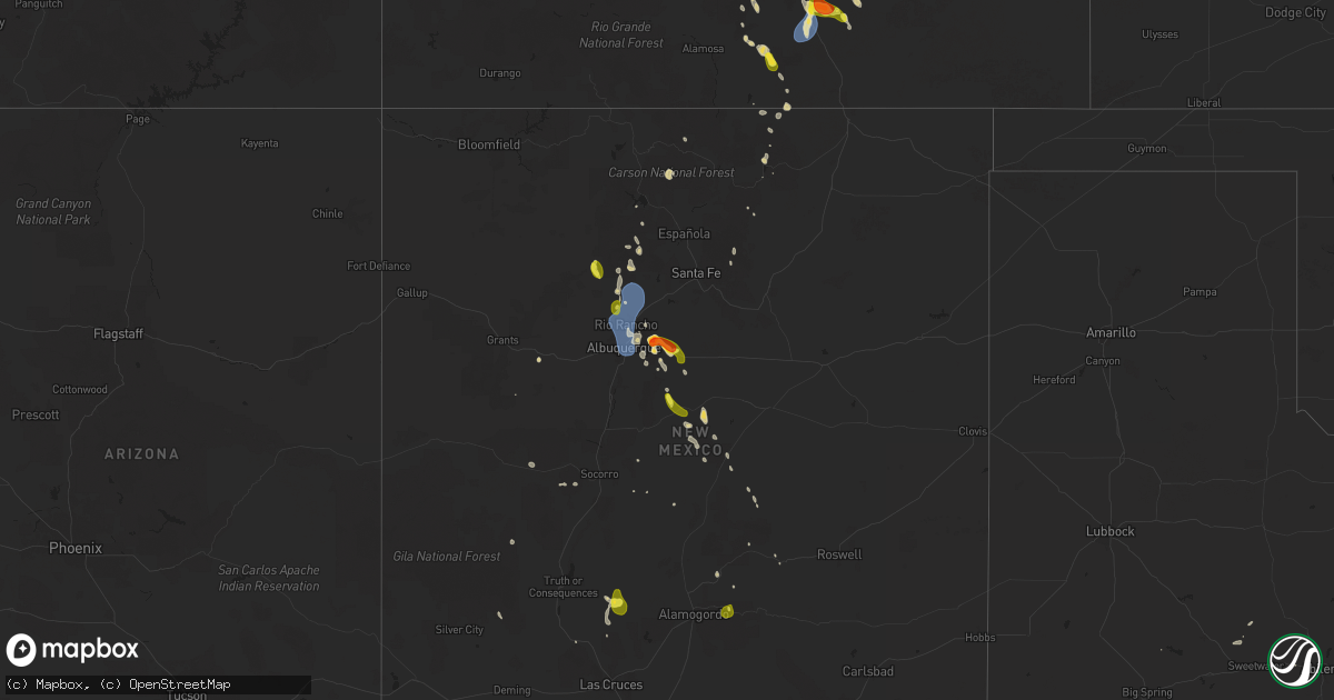
July 12 map
$229
one time, instant access
Download today. No call, no setup
Keep the $229
Bought the map and want the full workflow? Apply the entire $229 to a subscription within 7 days. None of it is wasted.
Every map, not just this one
This buys you this map. Subscription and you get every map we run, in the markets you choose from a few cities to whole states to nationwide. Plus real-time alerts the moment a storm fires.
Contact data
Name, contact info, occupancy, even credit band for addresses in the footprint. You go from where it hit to who to call.
Become the source they trust
Unlimited branding weather history reports on demand. You already have the documented answer ready for the property owner, and you are the one who showed up with it.
Property data and RoofTrace estimates
Pull up any address you have got, its value and the exact code rules for that jurisdiction, straight from One Click Code. Then RoofTrace estimates the squares, pitch, and roof value, priced the way you price.
States Impacted by Hail Map on July 12, 2025
Storm reports
Missouri
| Date | Description |
|---|---|
| 07/12/20252:54 PM CDT | Large 6 inch in diameter tree branch down on the north side of cape girardeau. |
| 07/11/20259:45 PM CDT | Tree limb was blown down. Time estimated from radar based on public report. |
Florida
| Date | Description |
|---|---|
| 07/12/20252:30 PM CDT | Multiple trees down on state route 100 east of florahome. Time estimated via radar. |
| 07/12/20252:00 PM CDT | Public nickel to quarter size hail along with street flooding near the area of coral spring nissan and the stranahan river. |
| 07/12/20251:40 PM CDT | Spotter reported up up to 1 inch in size near nw 27th & inverrary blvd. |
Kansas
| Date | Description |
|---|---|
| 07/12/20255:43 PM CDT | Measured hail stone. |
| 07/12/20255:41 PM CDT | Several tree limbs knoc |
| 07/12/20255:41 PM CDT | Up to golf ball sized hail. Delayed report. Time estimated by radar. |
| 07/12/20255:41 PM CDT | Several tree limbs knocked down. Delayed report. Time estimated by radar. |
Kentucky
| Date | Description |
|---|---|
| 07/12/20256:04 PM CDT | Report of 2 trees down along isabella street in newport... Between 7th and 8th streets. Time estimated from radar. |
| 07/12/20255:39 PM CDT | A local report indicates 59 MPH wind near 1 N Gage |
| 07/12/20255:30 PM CDT | Delayed report. Tree damage occurred along albert hook rd and ceredo rd to the south and southeast of la center. One residence had some damage to a pool and outdoor fur |
| 07/12/20251:27 PM CDT | A social media report said a porch roof was peeled halfway off on the 100 block of bethany school lane. Time estimated from radar. |
South Carolina
| Date | Description |
|---|---|
| 07/12/20255:43 PM CDT | Local media relayed photos of multiple trees down due to a downburst in sumter. Time estimated by radar. |
| 07/12/20255:37 PM CDT | Kershaw county dispatch reported multiple trees down in the area of white pond rd at ft jackson rd. Time estimated by radar. |
| 07/12/20252:45 PM CDT | Tree down near the intersection of broad river blvd and river chase blvd. Time based on report received by the 911 call center. |
Colorado
| Date | Description |
|---|---|
| 07/12/20254:10 PM CDT | Hail lasted 30 minutes. |
| 07/11/20257:15 PM CDT | Awos st |
| 07/11/20257:15 PM CDT | Awos station k4v1 4 n wal |
| 07/11/20257:15 PM CDT | Aw |
| 07/11/20257:15 PM CDT | Awos station k4v1 4 n walsenburg. |
Virginia
| Date | Description |
|---|---|
| 07/12/20255:03 PM CDT | Large tree down at 11409 drop forge ln |
| 07/12/20254:01 PM CDT | Tree down in the roadway at kettle pond lane near route 7. |
| 07/12/20253:27 PM CDT | Two trees reported down near thornhil |
| 07/12/20253:27 PM CDT | Two trees reported down near thornhill. |
| 07/12/20253:18 PM CDT | Two trees down just west of lahore on lahore road. |
| 07/12/20252:43 PM CDT | The 911 call center reported a tree down along i-95 northbound near mile marker 35. Vdot reported the tree down at mile marker 35.2. Time estimated from radar. |
| 07/12/20252:16 PM CDT | The 911 call center reported a tree down along the intersection of va 33 and va 249. Time estimated from radar. |
| 07/12/20252:11 PM CDT | The 911 call center reported a tree down along the intersection of cooks mill road and highway 249. |
| 07/12/20251:28 PM CDT | 4 different reports of downed trees across scottsville. |
| 07/12/20251:04 PM CDT | Tree reported down on old buckingham rd blocking all lanes. |
| 07/12/202512:48 PM CDT | A 64 mph wind gust was measured by the richmond international airport asos. |
| 07/12/202512:35 PM CDT | 5 trees down in the 4000 block of monocan trail road |
| 07/12/202512:20 PM CDT | A large tree fell across peach court near bassett... Va... Blocking the road. |
| 07/12/202512:13 PM CDT | Tree down on power lines along cedar street. |
Michigan
| Date | Description |
|---|---|
| 07/12/20251:18 PM CDT | Report and photos of multiple trees and large branches down |
| 07/12/202512:40 PM CDT | A local report indicates 61 MPH wind near 3 E Detroit |
| 07/12/202512:25 PM CDT | Report of large trees down across the city of dearborn |
| 07/12/202512:04 PM CDT | Large tree uprooted... Likely shallow rooted system. |
| 07/12/202511:36 AM CDT | Report of a large tree limb down on road |
| 07/12/202511:35 AM CDT | Photos of several large trees either uprooted or snapped in half |
| 07/12/202511:35 AM CDT | Report of tree limbs down... Approximately 6 to 8 inches diamter |
| 07/12/202511:13 AM CDT | Report and photo of a large tree limb down. |
Illinois
| Date | Description |
|---|---|
| 07/12/202512:40 PM CDT | Delayed report. Structural damage to a home due to a large tree falling. |
Pennsylvania
| Date | Description |
|---|---|
| 07/11/20257:16 PM CDT | A tree was reported down over farkas road. |
Texas
| Date | Description |
|---|---|
| 07/12/20256:43 PM CDT | Public report of trees and power lines down near eastman chemical company. |
| 07/12/20256:43 PM CDT | Public report of trees and power lines down near eastman chem |
| 07/12/20256:40 PM CDT | Dispatch reported trees and powerlines down near intersection of fm 349 and fm 2276. |
| 07/12/20256:40 PM CDT | Dispatch reported trees and powerlines down on tx 322 near fm 2011. |
| 07/12/20256:35 PM CDT | Dispatch reported trees and powerlines down on us 259 east of overton. |
| 07/12/20256:17 PM CDT | Dispatch reported trees and power lines down in new chapel hill. |
| 07/12/20256:14 PM CDT | Dispatch report of trees and powerlines down east of troup. |
| 07/12/20256:02 PM CDT | County dispatch reported several trees and powerlines down on the north side of the county towards troup. |
| 07/12/20255:20 PM CDT | Report of tree down due to thunderstorm wind gusts. |
| 07/12/20255:20 PM CDT | Report of tree down due to thunderstorm wind gusts. |
| 07/12/20255:18 PM CDT | Asos station kcxo conroe. |
Oklahoma
| Date | Description |
|---|---|
| 07/12/20256:19 PM CDT | Quarter size hail reported in broken bow. |
Maryland
| Date | Description |
|---|---|
| 07/12/20255:37 PM CDT | Multiple trees and power lines down across accident... Md. |
| 07/12/20255:37 PM CDT | Multiple trees and power lines down across accident... Md. |
| 07/12/20255:21 PM CDT | 911 call center reported numerous trees and power lines down across mchenry... Md. |
| 07/12/20255:08 PM CDT | Large tree down on creagerstown rd near magnolia meadows farms |
| 07/12/20255:04 PM CDT | One tree and numerous branches down west of woodsboro on gravel hill road. |
| 07/12/20255:00 PM CDT | Tree down reported at the intersection of mountaindale road and masser road. |
Tennessee
| Date | Description |
|---|---|
| 07/12/20251:30 PM CDT | Tree down. |
Indiana
| Date | Description |
|---|---|
| 07/12/20255:14 PM CDT | Trees down on power lines along bielby road northwest of greendale. Time estimated from radar. |
| 07/12/20254:57 PM CDT | Several trees down near the intersection of s benham rd and e county rd 800 s. |
| 07/12/20254:31 PM CDT | Tree down across powerline on meek road south of centerville. |
| 07/12/20252:41 PM CDT | Tree down on power line on club road. |
| 07/12/20252:40 PM CDT | Multiple trees down at state road 26 and 800 e. Time estimated via radar. |
| 07/12/20252:40 PM CDT | Multiple trees down at 600 e and 100 s near belfountain. Time estimated via radar. |
| 07/12/20252:05 PM CDT | 60 mph wind gust within the rain core. Power is flickering. |
| 07/12/20251:54 PM CDT | A local report indicates 58 MPH wind near 2 S Princeton |
North Carolina
| Date | Description |
|---|---|
| 07/12/20255:46 PM CDT | Multiple trees/power lines down. |
| 07/12/20254:31 PM CDT | Several outages due to fallen trees on power lines. |
| 07/12/20254:25 PM CDT | Asos station kint winston salem measured a 62 mph wind gust. |
| 07/12/20254:23 PM CDT | Corrects previous tstm wnd gst report from kint. Gust occurred at 523 pm - pk wnd 28054/2123. |
| 07/12/20254:18 PM CDT | Reports of 10 or more homes damaged from downed trees... 20 to 30 people misplaced. |
| 07/12/20253:24 PM CDT | Multiple trees downed by thunderstorm winds... Mainly in the northern half of yadkin county. |
| 07/12/20253:21 PM CDT | Multiple trees reported down on spainhour mill road. |
| 07/12/20253:14 PM CDT | Tree downed by thunderstorm winds at the intersection of cockerham road and west mount herman church road. |
| 07/12/20253:12 PM CDT | Tree downed by thunderstorm winds on hauser road... Blocking the road. |
| 07/12/20253:12 PM CDT | Tree downed by thunderstorm winds near the intersection of hauser road and caudle road... And blocked the road. |
| 07/12/20252:51 PM CDT | Tree downed by thunderstorm winds on beach road. |
New Mexico
| Date | Description |
|---|---|
| 07/12/20256:30 PM CDT | Reported by nws student observer. |
| 07/11/20257:27 PM CDT | Asos station kabq albuquerque intl sunport. |
| 07/11/20257:25 PM CDT | Location estimated. 1 inch and 1.25 inch hail reported by a spotter in edgewood. |
| 07/11/20257:06 PM CDT | A local report indicates 1.00 inch wind near 3 N Sedillo |
| 07/11/20257:05 PM CDT | Location estimated. Golf ball sized hail reported along cedar crest. |
Ohio
| Date | Description |
|---|---|
| 07/12/20255:57 PM CDT | Two large trees down near the intersection of new carlisle pike and mckees mill run. Time est from radar. |
| 07/12/20255:45 PM CDT | Large tree down and multiple large branches snapped. Time est from radar. |
| 07/12/20255:38 PM CDT | Corrects previous tstm wnd dmg report from tipp city. Several reports of trees down in tipp city. Time estimated from radar. |
| 07/12/20255:38 PM CDT | Several reports of trees down in tipp city. Time estimated from radar. |
| 07/12/20255:37 PM CDT | Numerous reports of trees down on the south side of troy. Time estimated from radar. |
| 07/12/20255:37 PM CDT | A local report indicates 60 MPH wind near 2 NW Vandalia |
| 07/12/20255:35 PM CDT | Multiple trees down along wolf creek. |
| 07/12/20254:45 PM CDT | High water on jerome rd and hill rd. |
| 07/12/20254:23 PM CDT | Large tree down on transformer. Time est from radar. |
| 07/12/20253:35 PM CDT | 6 foot long tree branches down in the choctaw lake area. Time estimated from radar. |
| 07/12/20253:26 PM CDT | Roof off a shed in roachester. |
| 07/12/20253:24 PM CDT | Tree down near little miami river. |
| 07/12/20253:00 PM CDT | Trees and powerlines down in the 300 block of laramie. |
| 07/12/20252:56 PM CDT | Large tree limb down in florence township. |
| 07/12/20252:55 PM CDT | Trees down along burns avenue... Near both cooper and east mills. Time estimated from radar. |
| 07/12/20252:54 PM CDT | Several trees down in lincoln heights. Downed trees reported near the intersection of prairie ave and leggett st... |
| 07/12/20252:54 PM CDT | Several trees down in lincoln heights. Downed trees reported near the intersection of prairie ave and leggett st... Along with wabash ave. |
| 07/12/20252:54 PM CDT | Trees and powerlines down along woodknoll terrace. Time estimated from radar. |
| 07/12/20252:49 PM CDT | Several large tree branches down on main street near mill street as well as near bellamy road. Diameter of branches were between 12 to 24 inches. |
| 07/12/20252:45 PM CDT | Several large branches downed on arlington road between sr 113 and sr 61... With a diameter of around 18 to 24 inches. |
| 07/12/20252:45 PM CDT | Several trees across the road in huron township. Time was estimated by radar. |
| 07/12/20252:24 PM CDT | Large tree down onto powerlines near the intersection of anderley rd and brown rd. |
| 07/12/20251:59 PM CDT | Trees down with two power poles and wires down on state route 430 at the entrance to charles mills lake park. Time estimate via radar. |
| 07/12/202512:15 PM CDT | Large tree limb down on power lines. |
| 07/12/202511:45 AM CDT | Several trees down across the area near oak openings preserve metropark. |
Cities Impacted by Hail Map on July 12, 2025
- Grover, CO
- Briggsdale, CO
- Ann Arbor, MI
- South Lyon, MI
- Northville, MI
- Canton, MI
- Plymouth, MI
- Romulus, MI
- Rotan, TX
- Taylor, MI
- Dearborn Heights, MI
- Raleigh, IL
- Eldorado, IL
- Irvine, KY
- Detroit, MI
- Ecorse, MI
- River Rouge, MI
- Stanton, KY
- Richmond, VA
- Henrico, VA
- Sandston, VA
- Sweetwater, TX
- Suffolk, VA
- Hopewell, VA
- Fort Lauderdale, FL
- Hillsboro, KY
- Wallingford, KY
- Scottsville, VA
- Edwardsport, IN
- Prince George, VA
- Providence Forge, VA
- Charles City, VA
- Linton, IN
- Pompano Beach, FL
- Enid, OK
- Hunter, OK
- Fairmont, OK
- Palmyra, VA
- Babson Park, FL
- Lake Wales, FL
- Perry, OK
- Garber, OK
- Connelly Springs, NC
- Guthrie, OK
- Edmond, OK
- Lyons, IN
- Cashion, OK
- Owensville, IN
- Fort Branch, IN
- Princeton, IN
- Francisco, IN
- Oakland City, IN
- Petersburg, IN
- Stendal, IN
- Winslow, IN
- Spurgeon, IN
- Sandborn, IN
- Walker, LA
- Livingston, LA
- Lanexa, VA
- New Kent, VA
- Switz City, IN
- Hickory, NC
- Coral Springs, FL
- Billings, OK
- Morrison, OK
- Velpen, IN
- Otwell, IN
- Red Rock, OK
- West Point, VA
- Corapeake, NC
- Tyner, NC
- Merkel, TX
- Boca Raton, FL
- Grove City, OH
- Belvidere, NC
- Hobbsville, NC
- Huntingburg, IN
- Jasper, IN
- Marble Hill, MO
- Whitewater, MO
- Burfordville, MO
- Jackson, MO
- Cape Girardeau, MO
- Dubois, IN
- Saint Anthony, IN
- Bloomfield, IN
- Petersburg, VA
- Clermont, FL
- Winter Garden, FL
- Berlin Heights, OH
- Huron, OH
- Wakeman, OH
- Celestine, IN
- Loogootee, IN
- French Lick, IN
- Shoals, IN
- McClure, IL
- Throckmorton, TX
- Navasota, TX
- West Baden Springs, IN
- Vermilion, OH
- Amherst, OH
- Paoli, IN
- Orleans, IN
- Taylor, AR
- Saint Cloud, FL
- Wagarville, AL
- Hilton Head Island, SC
- Rosanky, TX
- Norwalk, OH
- Milan, OH
- Oklahoma City, OK
- Campbellsburg, IN
- Salem, IN
- Knightstown, IN
- Greenfield, IN
- Wilkinson, IN
- Charlottesville, IN
- Waelder, TX
- Indianapolis, IN
- West Palm Beach, FL
- Delray Beach, FL
- Wellington, FL
- Shirley, IN
- Rome, IN
- Tell City, IN
- Cannelton, IN
- Derby, IN
- Hardinsburg, KY
- Stephensport, KY
- Battletown, KY
- Union Star, KY
- Payneville, KY
- Webster, KY
- Rhodelia, KY
- Brandenburg, KY
- Irvington, KY
- Harned, KY
- Spiceland, IN
- New Castle, IN
- Lewisville, IN
- Hamilton, AL
- Zavalla, TX
- Plain Dealing, LA
- Disputanta, VA
- Carson, VA
- Huntsville, TX
- Straughn, IN
- Hagerstown, IN
- Willis, TX
- Mooreland, IN
- Economy, IN
- Saint Stephens, AL
- Mccomb, MS
- Magnolia, MS
- Conroe, TX
- New Waverly, TX
- Florissant, CO
- Guffey, CO
- Williamsburg, IN
- Modoc, IN
- Fountain City, IN
- Weston, CO
- Advance, MO
- Ryan, OK
- Arcadia, OK
- Jones, OK
- Spencer, OK
- Guston, KY
- Spearsville, LA
- Elkin, NC
- Bronte, TX
- Catharpin, VA
- Manassas, VA
- Golconda, IL
- Port Saint Lucie, FL
- Gainesville, VA
- Haymarket, VA
- Dupont, IN
- Madison, IN
- Holton, IN
- Versailles, IN
- Cross Plains, IN
- Eaton, OH
- New Paris, OH
- Lewisburg, OH
- Eustace, TX
- Eagle Nest, NM
- Henrietta, TX
- Winston Salem, NC
- Brookville, OH
- Menard, TX
- Naples, FL
- Biggers, AR
- Bunnell, FL
- Grantsburg, IL
- Commiskey, IN
- Paris Crossing, IN
- Deputy, IN
- Tererro, NM
- Oviedo, FL
- Clayton, OH
- Englewood, OH
- West Milton, OH
- Tipp City, OH
- Troy, OH
- Ringling, OK
- Fall River, KS
- La Veta, CO
- Casstown, OH
- Saint Paris, OH
- New Carlisle, OH
- Christiansburg, OH
- Conover, OH
- Vandalia, OH
- Urbana, OH
- Fredonia, KS
- Toronto, KS
- Deland, FL
- De Leon Springs, FL
- Sanford, FL
- Port Orange, FL
- Buffalo, KS
- West Alexandria, OH
- Daytona Beach, FL
- Benedict, KS
- Bowie, TX
- Klondike, TX
- Cumby, TX
- Yates Center, KS
- Chanute, KS
- Humboldt, KS
- West Liberty, OH
- Broken Bow, OK
- Alto, TX
- Rusk, TX
- Gilmer, TX
- Bellevue, TX
- Sulphur Springs, TX
- Woodway, TX
- Geneva, FL
- San Ysidro, NM
- Rio Rancho, NM
- Bernalillo, NM
- Flemingsburg, KY
- Lugoff, SC
- Elgin, SC
- Palm City, FL
- Indiantown, FL
- Overton, TX
- Henderson, TX
- Kilgore, TX
- Longview, TX
- Hallsville, TX
- Winchester, KY
- Albany, TX
- Moores Hill, IN
- Porum, OK
- Vian, OK
- Canon City, CO
- Algodones, NM
- Tijeras, NM
- Cedar Crest, NM
- Sandia Park, NM
- Rye, CO
- Walsenburg, CO
- Jacksonville, TX
- Idabel, OK
- Louisville, MS
- Troup, TX
- Austin, IN
- Crothersville, IN
- Trinity, TX
- Edgewood, NM
- Truth Or Consequences, NM
- Newport, AR
- Paris, TX
- Powderly, TX
- Vallecitos, NM
- Osteen, FL
- Augusta, GA
- Hephzibah, GA
- Selman City, TX
- Arthur City, TX
- New Smyrna Beach, FL
- Albuquerque, NM
- Corrales, NM
- Placitas, NM
- Kirtland Afb, NM
- Moriarty, NM
- Stanley, NM
- Estancia, NM
- Mountainair, NM
- Willard, NM
- Mescalero, NM
- Westcliffe, CO
- Waynesboro, GA
- Fort Garland, CO
- Richmond Hill, GA
- Mount Orab, OH
- Williamsburg, OH
- Savannah, GA
- Wilson, OK
- Keyser, WV
- Walters, OK
- Comanche, OK
- Canton, MS
- Randlett, OK
- Marshall, TX
- Jemez Springs, NM
- Las Cruces, NM
- Temple, OK
- Brownwood, TX
- Macon, MS
- Hugo, OK
- Pueblo, CO
- Staunton, VA
- Rattan, OK
- North Vernon, IN
- Rembert, SC
- Havana, AR
- Avondale, CO
- Chacon, NM
- Beaufort, SC
- Belleville, AR
- Datil, NM
- Ponderosa, NM
- Cement, OK
- Ninnekah, OK
- Hatch, NM
- Corona, NM
- Arlington, KY
- Abingdon, VA
- Summerfield, FL
- La Center, KY
- Barlow, KY
- Wickliffe, KY
- Kevil, KY
- Rush Springs, OK
- Marlow, OK
- Fancy Farm, KY
- Mayfield, KY
- Bardwell, KY
- Clinton, KY
- West Paducah, KY
- Mendenhall, MS
- Capitan, NM
- Goldthwaite, TX
- Hendrix, OK
- Mitchell, GA
- Hewitt, TX
- Waco, TX
- Comanche, TX
- Little Elm, TX
- Blum, TX
- Clifton, TX
- Valley Mills, TX
- Wingo, KY
- Whitney, TX
- Fletcher, OK
- Batavia, OH
- Waco, KY
- Mayhill, NM
- Cloudcroft, NM
- Bokchito, OK
- Big Sandy, TX
- Broaddus, TX
- Arp, TX
- Rocksprings, TX
- Sonora, TX
- Eldorado, TX