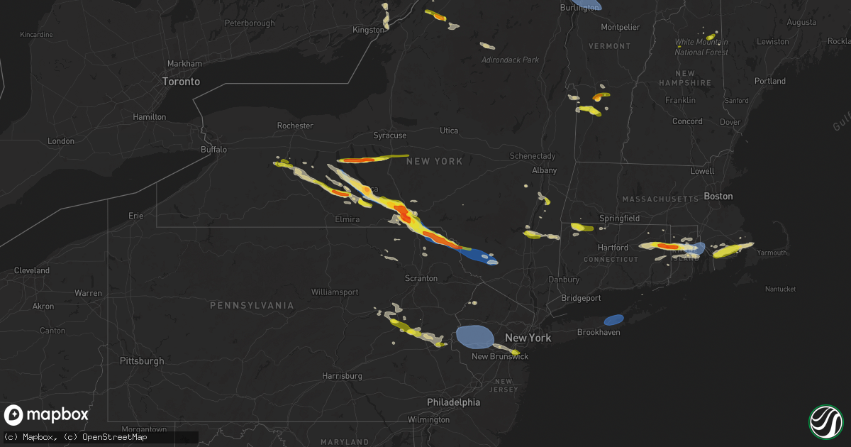
Hail Map on July 3, 2025
Get this storm
July 3 map
$229
one time, instant access
Download today. No call, no setup
Keep the $229
Bought the map and want the full workflow? Apply the entire $229 to a subscription within 7 days. None of it is wasted.
Every map, not just this one
This buys you this map. Subscription and you get every map we run, in the markets you choose from a few cities to whole states to nationwide. Plus real-time alerts the moment a storm fires.
Contact data
Name, contact info, occupancy, even credit band for addresses in the footprint. You go from where it hit to who to call.
Become the source they trust
Unlimited branding weather history reports on demand. You already have the documented answer ready for the property owner, and you are the one who showed up with it.
Property data and RoofTrace estimates
Pull up any address you have got, its value and the exact code rules for that jurisdiction, straight from One Click Code. Then RoofTrace estimates the squares, pitch, and roof value, priced the way you price.
States Impacted by Hail Map on July 3, 2025
Storm reports
Connecticut
| Date | Description |
|---|---|
| 07/03/20256:02 PM CDT | Trees and wires down in essex... Lyme... And old lyme. Time estimated by radar. |
| 07/03/20255:58 PM CDT | Several trees and wires down in deep river. Time estimated by radar. |
| 07/03/20255:55 PM CDT | Power poles and trees down across several roads. Time estimated by radar. |
| 07/03/20255:50 PM CDT | Multiple streets closed due to downed trees and wires throughout town including durham road... Nortontown road... Moose hill road... And south fair street. |
| 07/03/20255:45 PM CDT | Golf ball sized hail was reported which destroyed a gazebo. |
| 07/03/20255:40 PM CDT | Corrects previous hail report from danielson. Quarter size hail. |
| 07/03/20255:40 PM CDT | Quarter size hail. Time estimated from radar. |
| 07/03/20255:35 PM CDT | Trees down in town. Time estimated from radar. |
| 07/03/20255:33 PM CDT | Report of a number of branches down. |
| 07/03/20255:30 PM CDT | Multiple trees and wires down around westport causing power outages. Time estimated by radar. |
| 07/03/20255:28 PM CDT | Tree down on wires and blocking road on bayne street. Time estimated by radar. |
| 07/03/20255:26 PM CDT | Ct dot reports tree down on roadway at ct 188 and benson rd. Time estimated from radar. |
| 07/03/20255:20 PM CDT | Multiple roads closed due to trees and power lines down in madison including east wharf road near fence creek... Warpas road between amber trail and godman road and map |
| 07/03/20255:15 PM CDT | Corrects previous tstm wnd dmg report from guilford. Multiple streets closed due to downed trees and wires throughout town including durham road... Nortontown road... M |
| 07/03/20255:11 PM CDT | Report of tree down on wires near the intersection of cowles road and quanopaug trail. Time estimated from radar. |
| 07/03/20255:03 PM CDT | Corrects previous tstm wnd dmg report from 3 nnw gaylordsville. Trees and wires downed and laying across route 7. The roadway was closed between bulls bridge road and c |
| 07/03/20254:55 PM CDT | Trees and wires downed and laying across route 7. The roadway was closed between bulls bridge road and ct route 341. |
| 07/03/20254:55 PM CDT | Social media report of trees down. Time estimated from radar. |
| 07/03/20254:54 PM CDT | Broadcast media reports wires and trees down across milford. Time estimated by radar. |
| 07/03/20254:50 PM CDT | *** 1 inj *** tree down on vehicle with occupants inside on white plains road at merritt parkway. One injury reported. |
| 07/03/20254:50 PM CDT | Large tree and power lines down on merrimac drive. |
| 07/03/20254:45 PM CDT | Trees reported down on wynwood dr and standish st. |
| 07/03/20254:43 PM CDT | Trees/wires reported down king street and king court. |
| 07/03/20254:30 PM CDT | Tree down on center st near indian mountain rd. Time estimated from radar. |
| 07/03/20254:10 PM CDT | Tree snapped and downed on reservoir road. |
| 07/03/20254:10 PM CDT | Tree snapped and downed on rese |
Arizona
| Date | Description |
|---|---|
| 07/03/20255:30 PM CDT | From social media. Location estimated. |
| 07/03/20255:30 PM CDT | Corrects location of previous hail report from cornville. From social media. |
| 07/03/20254:30 PM CDT | Palm tree knocked down due to thunderstorm winds. Storm also had nickel sized hail. |
| 07/03/20254:30 PM CDT | Location estimated... Size estimated from social media picture. |
| 07/02/20257:55 PM CDT | Downed power lines resulting in road closure. Time estimated based on radar. |
| 07/02/20257:50 PM CDT | A local report indicates 58 MPH wind near 4 SSE Coolidge |
Maine
| Date | Description |
|---|---|
| 07/03/20252:48 PM CDT | Tree down on powerlines on water st. Time estimated by radar. |
| 07/03/20251:41 PM CDT | 911 caller reported a tree down in the howland area. Time estimated by radar. |
| 07/03/20251:00 PM CDT | 911 caller reported a tree down in east millinocket. Time estimated by radar. |
| 07/03/202512:43 PM CDT | Trees down on north stage coach rd in atkinson... Me. Time estimated by radar. |
| 07/03/202512:27 PM CDT | Tree across parsonsfield road in limerick. |
| 07/03/202512:27 PM CDT | Tree ac |
| 07/03/202512:13 PM CDT | Trees and powerlines down in the sangerville... Me area. Time estimated by radar. |
| 07/03/202511:50 AM CDT | Tree down blocking rt-302. Time estimated by radar. |
| 07/03/202511:40 AM CDT | Norway fire reported a large tree blown over onto powerlines on round the pond rd in norway. Time estimated by radar. |
| 07/03/202511:24 AM CDT | A tree was observed to be leaning on a powerline in the caribou area. Time estimated by radar. |
| 07/03/202511:20 AM CDT | Wires down. |
| 07/03/202510:53 AM CDT | 6-8 trees down across powerlines in the grand isle area. Time estimated by radar. |
| 07/03/202510:42 AM CDT | Trees and powerlines down in the madawaska... Me area. Time estimated by radar. |
| 07/03/202510:42 AM CDT | Multiple trees and powerlines down in the portage... Me area. Time estimated by radar. |
| 07/03/202510:38 AM CDT | A local report indicates 1.00 inch wind near 2 S Easton |
| 07/03/202510:38 AM CDT | Corrects previous hail report from 2 nnw westfield. Hail mostly nickel size... With a few up to half dollar size. |
Michigan
| Date | Description |
|---|---|
| 07/03/20254:30 PM CDT | Numerous 1-2 inch diameter tree branches down in eaton rapids. |
Idaho
| Date | Description |
|---|---|
| 07/03/20256:40 PM CDT | Medium tree... Approximately 1 foot in diameter... With shallow roots blown over in estimated 45 mph outflow winds. Station elevation: 4926 ft. |
| 07/02/202511:00 PM CDT | Mesonet station msi04 pilot gold. |
New Hampshire
| Date | Description |
|---|---|
| 07/03/202511:34 AM CDT | Large tree down on river road near lower road in new ipswich. |
| 07/03/202511:25 AM CDT | Tree and wires down in the area of blossom street. |
| 07/03/202511:12 AM CDT | Tree down on perimeter road next to manchester airport. |
| 07/03/202511:06 AM CDT | Tree down on a house on merrill court in milford. |
| 07/03/202511:05 AM CDT | Tree down on maple street in manchester. |
| 07/03/202511:00 AM CDT | Lare tree and wires down at riverway east parking lot in milford. |
| 07/03/202510:47 AM CDT | Tree and wires down on zoski road in deering. |
| 07/03/202510:40 AM CDT | Photos of hailstones next to ruler. Largest stones were half dollar-sized. Time estimated by radar. |
| 07/03/202510:35 AM CDT | Numerous large branches and a few trees downed along rt-302. |
| 07/03/202510:35 AM CDT | A tree and wires down along bean road in moultonborough. |
| 07/03/202510:24 AM CDT | Multiple reports of downed trees. Tree fell on car in motel parking lot off daniel webster highway. |
| 07/03/202510:05 AM CDT | Hail at hancock campground on the kancamagus highway. Hail between 0.75 to 1.1 inches. Hail fell for about 7 minutes. Winds estimated over 50 mph as well. |
Montana
| Date | Description |
|---|---|
| 07/02/202510:43 PM CDT | Asos station kbhk baker. |
Florida
| Date | Description |
|---|---|
| 07/03/20252:35 PM CDT | Several trees down on the northern side of interlachen. Time estimated via radar. |
South Dakota
| Date | Description |
|---|---|
| 07/02/202510:45 PM CDT | A local report indicates 58 MPH wind near 1 ESE Ladner |
| 07/02/202510:23 PM CDT | A local report indicates 71 MPH wind near 1 N Buffalo |
| 07/02/202510:13 PM CDT | A local report indicates 62 MPH wind near 1 N Buffalo |
Minnesota
| Date | Description |
|---|---|
| 07/02/20259:43 PM CDT | Report from mping: quarter |
Vermont
| Date | Description |
|---|---|
| 07/03/20256:18 PM CDT | Trees down and powerlines pulled from a house on college street. |
| 07/03/20255:55 PM CDT | Trees reported down along route 105 in enosburg. |
| 07/03/20255:55 PM CDT | A local report indicates 1.00 inch wind near 2 S East Berkshire |
| 07/03/20255:30 PM CDT | Tree down on riverside ave. |
| 07/03/20255:30 PM CDT | Wires down on plattsburg ave. |
| 07/03/20255:25 PM CDT | A local report indicates 58 MPH wind near Sand Bar State Park |
| 07/03/20254:08 PM CDT | Silver dollar size hail reported. |
| 07/03/20253:40 PM CDT | Quarter sized |
| 07/03/202512:50 PM CDT | Tree down on river road |
| 07/03/202511:40 AM CDT | Two trees fell into the parking lot of votey hall at uvm. One tree fell into a parked car and caused damage. |
| 07/03/202511:18 AM CDT | Tree down into powerlines on west shore road in south hero/keeler bay. |
Iowa
| Date | Description |
|---|---|
| 07/03/20256:19 PM CDT | Six inch tree limbs broken in grundy center. Time estimated by radar. |
| 07/03/20256:18 PM CDT | Personal weather station. |
| 07/02/20258:30 PM CDT | A local report indicates 1.00 inch wind near Manchester |
| 07/02/20258:25 PM CDT | Hail ranging from half inch to quarter size. |
| 07/02/20257:30 PM CDT | Delayed report. Outbuilding damaged and large tree branches downed. |
New York
| Date | Description |
|---|---|
| 07/03/20256:13 PM CDT | Photo shared by nyc emergency management of quarter sized hail in hugu |
| 07/03/20256:13 PM CDT | Photo shared by nyc emergency management of quarter sized hail in huguenot. |
| 07/03/20256:10 PM CDT | A local report indicates 60 MPH wind near 1 NE Calverton |
| 07/03/20255:35 PM CDT | Large tree down on christopher lane near croton place. |
| 07/03/20255:28 PM CDT | Corrects previous hail report from huguenot. Photo shared by nyc emergency management of quarter sized hail in huguenot. Time estimated from radar. |
| 07/03/20255:25 PM CDT | A local report indicates 0 MPH wind near 1 NNE Annadale |
| 07/03/20255:25 PM CDT | Large tree down on cromer street. |
| 07/03/20255:25 PM CDT | Corrects previous tstm wnd dmg report from 1 wsw westerleigh. Large tree down on christopher lane near croton place. |
| 07/03/20255:20 PM CDT | Large tree down on rae avenue. |
| 07/03/20255:09 PM CDT | Ny dot reports tree down on ny 100 at saw mill river road. All lanes closed. Time estimated from radar. |
| 07/03/20255:00 PM CDT | Tree down and blocking lanes on taconic state parkway near rossway road. |
| 07/03/20255:00 PM CDT | Multiple reports of trees and wires down in plattburgh and beekmantown. |
| 07/03/20254:55 PM CDT | Tree down on wires. Old castle point road is impassable. |
| 07/03/20254:54 PM CDT | Tree and wires down on mahoney road. |
| 07/03/20254:50 PM CDT | Wires on house. |
| 07/03/20254:50 PM CDT | Trees and wires down on military turnpike. |
| 07/03/20254:46 PM CDT | Tree and wires down on herman drive. |
| 07/03/20254:46 PM CDT | Wires down. |
| 07/03/20254:45 PM CDT | Tree downed in lagrange. |
| 07/03/20254:43 PM CDT | Tree on wires. |
| 07/03/20254:43 PM CDT | Corrects previous tstm wnd dmg report from 1 nne chester. Tree on wires. |
| 07/03/20254:37 PM CDT | Tree and wires down. |
| 07/03/20254:37 PM CDT | Corrects previous tstm wnd dmg report from 1 s goshen. Tree and wires down. |
| 07/03/20254:35 PM CDT | Wires downed on route 32. |
| 07/03/20254:30 PM CDT | Tree and wires downed on horsenden road. |
| 07/03/20254:24 PM CDT | Tree down on taconic state parkway northbound north of pumpkin lane. |
| 07/03/20254:23 PM CDT | Social media report of multiple large trees down on rte 82 in stanfordville. |
| 07/03/20254:20 PM CDT | Tree and wires down and on fire on arnott lane at goshen turnpike. |
| 07/03/20254:18 PM CDT | Broken pole and downed tension wires on highway 209 as per disptach feed. Radar-estimated time. |
| 07/03/20254:13 PM CDT | Tree down on over highway 209... As per dispatch feed. Radar-estimated time. |
| 07/03/20254:12 PM CDT | Two trees downed on a driveway. |
| 07/03/20254:12 PM CDT | Tree downed on ny route 9g at ny 308 in rhinebeck. Two lanes blocked. |
| 07/03/20254:10 PM CDT | Trees and wires down near mill road and brockway road. |
| 07/03/20254:09 PM CDT | Tree down on browns pond road near lake pleasant road in the town of clinton. |
| 07/03/20254:08 PM CDT | Tree downed and blocking traffic on us route 9 southbound between mill road and ackert hook road. |
| 07/03/20254:07 PM CDT | Trees downed on albany post road. |
| 07/03/20254:03 PM CDT | Trees downed in esopus. |
| 07/03/20254:00 PM CDT | Wires downed on minturn street. |
| 07/03/20254:00 PM CDT | Quarter size hail reported in the village of rhinebeck. |
| 07/03/20254:00 PM CDT | Quarter size hail reported in the village of rhinebeck. |
| 07/03/20253:58 PM CDT | Trees down on gallop... Perry... And taylor roads in the town of bangor. |
| 07/03/20253:56 PM CDT | Social media report of quarter size hail. Time estimated from radar. |
| 07/03/20253:55 PM CDT | Multiple trees down near the intersection of state route 11 and state route 11b. |
| 07/03/20253:55 PM CDT | Tree down and downed wires and road closure on us 9w both directions north of ulster avenue. |
| 07/03/20253:55 PM CDT | Trees and wires down in a couple locations... Including cold spring road as per dispatch feed. Radar-estimated time. |
| 07/03/20253:54 PM CDT | Trees and wires down on elk drive... As per dispatch feed. Radar-estimated time. |
| 07/03/20253:52 PM CDT | Trees and wires down on katrine lane. |
| 07/03/20253:50 PM CDT | Hail did damage to plants and garden. |
| 07/03/20253:50 PM CDT | Trees and wires down near lucas avenue at heritage drive. |
| 07/03/20253:49 PM CDT | A local report indicates 1.00 inch wind near 2 ENE Stottville |
| 07/03/20253:48 PM CDT | Shed blown into old monticello road as per dispatch feed. Radar-estimated time. |
| 07/03/20253:43 PM CDT | Social media report of a tree down near route 28 near beesmer road in kingston. |
| 07/03/20253:40 PM CDT | Multiple downed trees. Segar road as per dispatch feed. Radar-estimated time. |
| 07/03/20253:40 PM CDT | Quarter size hail in moria... Ny. |
| 07/03/20253:27 PM CDT | Half to silver dollar sized hail |
| 07/03/20253:20 PM CDT | Tree down on propane tank... As per dispatch feed. Hortonville area. Radar-estimated time. |
| 07/03/20253:18 PM CDT | Tree down on roadway... Near hilltop road... As per dispatch feed. Radar-estimated time. |
| 07/03/20253:12 PM CDT | Tree down onto powerlines on haggerty road in potsdam. |
| 07/03/20252:33 PM CDT | Numerous trees and wires down throughout broome county and the greater binghamton area. |
| 07/03/20252:27 PM CDT | Half to silver dollar sized hail |
| 07/03/20252:12 PM CDT | Tree down on conklin-kirkwood bridge. Pic sent to nws binghamton via social media. Radar-estimated time. |
| 07/03/20252:10 PM CDT | Pair of trees uprooted onto vehicle at a conklin road property... Heavily damaging it. Also lifted tow trailer. Pic sent to nws binghamton via social media. Radar-estim |
| 07/03/20252:04 PM CDT | Multiple trees down via social media photo in kirkwood ny. |
| 07/03/20252:04 PM CDT | Corrects previous tstm wnd dmg report from 1 n conklin. Multiple trees down via social media photo in kirkwood ny. |
| 07/03/20252:03 PM CDT | Estimated half dollar hail via social media photo. |
| 07/03/20252:03 PM CDT | Size estimated from photo. |
| 07/03/20252:03 PM CDT | Burst of pea sized hail with scattered quarter sized pieces. |
| 07/03/20252:00 PM CDT | Estimated hail size from photo. |
| 07/03/20252:00 PM CDT | Estimated half dollar hail via social media photo. |
| 07/03/20252:00 PM CDT | Large trees snapped and uprooted. Photo shared with nws of the tree damage. |
| 07/03/20252:00 PM CDT | Corrects previous tstm wnd dmg report from port dickinson. Numerous trees and wires down throughout broome county and the greater binghamton area. |
| 07/03/20252:00 PM CDT | A local report indicates 1.50 inch wind near Chenango Bridge |
| 07/03/20251:59 PM CDT | Nickel to quarter size hail in burdett. |
| 07/03/20251:59 PM CDT | Tree down over south apple gate road. |
| 07/03/20251:59 PM CDT | Tree down over trumansburg road. |
| 07/03/20251:59 PM CDT | Elongated hail... Size estimated from photo. |
| 07/03/20251:58 PM CDT | Multiple trees fallen on property on roosevelt avenue... Via social media photo. |
| 07/03/20251:58 PM CDT | Property damage reported. |
| 07/03/20251:58 PM CDT | Trees snapped... Property damage reported... 1 inch hail estimate. |
| 07/03/20251:56 PM CDT | A local report indicates 1.25 inch wind near 1 E Johnson City |
| 07/03/20251:55 PM CDT | Estimated hail on glen avenue. |
| 07/03/20251:55 PM CDT | Tree down over glen avenue... Property damage reported. |
| 07/03/20251:55 PM CDT | Trees on wires on bradley creek road. |
| 07/03/20251:55 PM CDT | Numerous trees down over upper front street. |
| 07/03/20251:55 PM CDT | Estimated 2 inch hail from social media photo. |
| 07/03/20251:52 PM CDT | Multiple uprooted trees... Downed power lines... And estimated 1 inch hail size. |
| 07/03/20251:50 PM CDT | Multiple photos of estimated golf ball size hail... Shown with a quarter coin via social media photo. |
| 07/03/20251:50 PM CDT | Portion of roof peeled off horse barn near airport. Picture sent to nws binghamton via social media. Radar-estimated time. |
| 07/03/20251:48 PM CDT | A local report indicates 1.75 inch wind near NWS Binghamton |
| 07/03/20251:47 PM CDT | Large pine trees down by power hill road. |
| 07/03/20251:47 PM CDT | Wires down over airport road. |
| 07/03/20251:45 PM CDT | Updates previous hail report from maine. Estimated golf ball size hail via social media photo. Also wind-driven hail damage to siding of house on state route 26. |
| 07/03/20251:45 PM CDT | Large snapped trees along hardy road. |
| 07/03/20251:45 PM CDT | Estimated golf ball size hail via social media photo. |
| 07/03/20251:45 PM CDT | Estimated ping pong hail via social media photo. |
| 07/03/20251:43 PM CDT | At least 10 trees down behind house on east maine road. Radar-estimated time. Photo sent to nws binghamton via social media. |
| 07/03/20251:40 PM CDT | Multiple uprooted trees along pollard hill road... Facing south-southwest. |
| 07/03/20251:35 PM CDT | 61 mph max wind gust reported at the berkshire nys mesonet. |
| 07/03/20251:05 PM CDT | Numerous trees and wires down through out tompkins county. |
| 07/03/20251:04 PM CDT | Tree down on amabel road. |
| 07/03/20251:04 PM CDT | Multiple trees down via social media photo in kirkwood ny. |
| 07/03/20251:02 PM CDT | Estimated golf ball size hail via social media photo. |
| 07/03/20251:02 PM CDT | Tree down in montour falls. |
| 07/03/20251:01 PM CDT | Estimated half dollar size hail via social media photo. |
| 07/03/20251:00 PM CDT | Trees and powerlines down on elmira road near robert treman state park. Picture sent to nws binghamton via social media. Radar-estimated time. |
| 07/03/20251:00 PM CDT | Quarter size hail estimated with a quarter coin in a picture on social media. |
| 07/03/20251:00 PM CDT | Corrects previous tstm wnd dmg report from 1 ene enfield. Tree down over south apple gate road. |
| 07/03/202512:59 PM CDT | Corrects timing of previous tstm wnd dmg report from 1 nw ithaca. Tree down over trumansburg road. |
| 07/03/202512:59 PM CDT | Corrects previous hail report from burdett. Nickel to quarter size hail in burdett. |
| 07/03/202512:50 PM CDT | Multiple reports of trees and wire down along mecklenburg road. |
| 07/03/202512:41 PM CDT | Estimated golf ball size hail via social media photo. |
| 07/03/202512:30 PM CDT | Large amount of at least quarter size hail in aurora. Photo shared via broadcaster social media. Radar-estimated time. |
| 07/03/202512:28 PM CDT | Tree down. Time estimated from radar. |
| 07/03/202512:06 PM CDT | Quarter sized hail reported on conesus lake. |
| 07/03/202511:21 AM CDT | Tree down on salmon river road in schuyler falls. |
| 07/03/202511:06 AM CDT | Tree down on lake shore road in chazy/ingrahm ny. |
New Jersey
| Date | Description |
|---|---|
| 07/03/20256:29 PM CDT | Tree down on house on woodland avenue. |
| 07/03/20256:16 PM CDT | Trees and wires down. Time estimated from radar. |
| 07/03/20256:10 PM CDT | Corrects previous tstm wnd dmg report from delaware twp. Trees and wires down. Time estimated from radar. |
| 07/03/20255:20 PM CDT | Trees and wires down near park avenue in avenel. Time estimated from radar. |
| 07/03/20255:17 PM CDT | Delayed report. Trees down and down power lines on route 27. Time estimated from radar. |
| 07/03/20255:15 PM CDT | Measured by a private weather station. |
| 07/03/20255:13 PM CDT | Trees and wires down along park avenue east of south plainfield. Time estimated from radar. |
| 07/03/20255:13 PM CDT | Trees and wires down along tingley lane. Time estimated from radar. |
| 07/03/20255:13 PM CDT | Large tree down on wires on annette drive. Time estimated from radar. |
| 07/03/20255:10 PM CDT | Multiple trees and power lines down. Time estimated from radar. |
| 07/03/20255:10 PM CDT | Large tree and some wires down on a vehicle with occupants trapped inside. Time estimated from radar. |
| 07/03/20255:08 PM CDT | Several large tree limbs down blocking roads around south plainfield. Time estimated from radar. |
| 07/03/20255:08 PM CDT | Multiple large trees down on wires across scotch plains. |
| 07/03/20255:07 PM CDT | Multiple trees down across north edison. Time estimated from radar. |
| 07/03/20255:05 PM CDT | Treen down on car on myrtle avenue. |
| 07/03/20255:05 PM CDT | Tree down on home on hillside avenue. |
| 07/03/20255:05 PM CDT | Corrects previous tstm wnd dmg report from 1 e plainfield. Multiple trees down on hillside avenue including a large on a home. |
| 07/03/20255:05 PM CDT | Corrects previous tstm wnd dmg report from fanwood. Tree down hitting moving train in fanwood. |
| 07/03/20255:05 PM CDT | Treen down hitting moving train in fanwood. |
| 07/03/20255:05 PM CDT | *** 2 fatal *** large tree fallen on car on myrtle avenue near mariners place with 2 occupants deceased. |
| 07/03/20255:05 PM CDT | Pictures shared on social media showed significant tree damage. Time estimated from radar. |
| 07/03/20255:05 PM CDT | Corrects previous tstm wnd dmg report from 2 wsw plainfield. Tree down on car on myrtle avenue. |
| 07/03/20255:03 PM CDT | *** 1 fatal *** a large tree and electrical wires fell on top of a vehicle with an occupant inside that had pulled over on greenbrook road due to the storm. Time estima |
| 07/03/20255:03 PM CDT | Green brook road completely blocked with trees down. Time estimated from radar. |
| 07/03/20255:01 PM CDT | Several trees and wires down along andrew street and park avenue in green brook township. Time estimated from radar. |
| 07/03/20255:00 PM CDT | Trees down all over north plainfield. Time estimated from radar. |
| 07/03/20254:55 PM CDT | Downed tree on i-78 westbound at west of exit 33 - cr 525/liberty corner rd/martinsville |
| 07/03/20254:54 PM CDT | Trees and wires down along king george road. Time estimated from radar. |
| 07/03/20254:54 PM CDT | Wires down and on fire on watchung road. Time estimated from radar. |
| 07/03/20254:47 PM CDT | Trees down across the roadway along madison avenue. Time estimated from radar. |
| 07/03/20254:44 PM CDT | Trees down along i-287 with lane restrictions reported. Time estimated from radar. |
| 07/03/20254:37 PM CDT | Trees and wires down. Time estimated from radar. |
| 07/03/20254:35 PM CDT | Trees down across phillipsburg. |
| 07/03/20254:32 PM CDT | Trees and wires down. Time estimated from radar. |
| 07/03/20254:15 PM CDT | Trained spotter sent in report of 62 mph gust recorded on a personal weather station. |
| 07/03/20253:13 PM CDT | Trees and wires down in sparta... Nj. Time estimated from radar. |
| 07/03/20253:12 PM CDT | Downed tree on us 206 northbound at south of goodale rd |
| 07/03/20253:00 PM CDT | Trees down on wires by mile marker 4 on route 623. Time estimated from radar. |
| 07/03/20253:00 PM CDT | Pictures of trees down along cr 52 at the top of cummins hill. Time estimated from radar. |
| 07/03/20252:58 PM CDT | Several trees and wires down around newton. Time estimated from radar. |
| 07/03/20252:57 PM CDT | Trees and wires down within stillwater. Time estimated from radar. |
| 07/03/20252:55 PM CDT | Several trees and wires down around hampton township. Time estimated from radar. |
| 07/03/20252:52 PM CDT | Power lines and power poles downed and on fire near hillcrest road. Time estimated from radar. |
| 07/03/20252:43 PM CDT | Trees and wires down near halsey road. Fire reported. Time estimated from radar. |
Louisiana
| Date | Description |
|---|---|
| 07/03/20256:39 PM CDT | Tree on power lines on cappel rd. |
| 07/03/20256:38 PM CDT | Report of utility lines down on martin springs rd. |
| 07/03/20255:54 PM CDT | Tree down on highway 117... South of provencal. |
Pennsylvania
| Date | Description |
|---|---|
| 07/03/20256:10 PM CDT | Tree downed on vehicle on state street. |
| 07/03/20255:54 PM CDT | Photo relayed of a large tree lying across rte 662 in perry twp. Time estimated from radar. |
| 07/03/20254:54 PM CDT | Picture sent in of quarter-size hail on social media. Time estimated from radar. |
| 07/03/20254:50 PM CDT | Pictures sent in via social media. Time given in report. |
| 07/03/20254:39 PM CDT | Widespread lines down across allen township. Time estimated from radar. |
| 07/03/20254:30 PM CDT | Wires down across the area. Time estimated from radar. |
| 07/03/20253:52 PM CDT | Trees and wires down around lower towamensing township. Time estimated from radar. |
| 07/03/20253:45 PM CDT | Trees and wires down with a fire reported on the 400 block of frable dr. Time estimated from radar. |
| 07/03/20253:43 PM CDT | Trees down on wires on the 400 block of elm street in franklin township. Time estimated from radar. |
| 07/03/20253:41 PM CDT | Picture of quarter sized hail sent in. Time estimated from radar. |
| 07/03/20253:40 PM CDT | Trees down on wires... Bending power poles over state route 92. Reported via pema. Radar-estimated time. |
| 07/03/20253:35 PM CDT | Spotter from hometown reported hail a little bigger than quarter size from a friend 2 miles north of her. |
| 07/03/20253:08 PM CDT | Tree down over road at wilcox road and galloway road as per dispatch feed. Radar-estimated time. |
| 07/03/20252:57 PM CDT | Significant tree and power line damage in the lakewood... Lake como... And equinunk areas. |
| 07/03/20252:48 PM CDT | Multiple trees and lines down from high winds according to buckingham township em. Radar-estimated time. |
| 07/03/20252:46 PM CDT | Numerous trees down. Time estimated from radar. |
| 07/03/20252:35 PM CDT | Tree down on house. Trees and wires down blocking roadway as well. Via dispatch feed. |
| 07/03/20252:35 PM CDT | Another tree down on house... Laurel street... Susquehanna depot. Other trees and wires down nearby in oakland. Radar-estimated time. |
| 07/03/20252:35 PM CDT | Update to prior report. 26 instances of various levels of home damage between susquehanna and oakland boros. Numerous downed trees. |
| 07/03/20252:25 PM CDT | Multiple trees and wires down in the area. |
| 07/03/20252:24 PM CDT | Corrects previous tstm wnd dmg report from 3 nw lanesboro. Multiple trees and wires down on oakhill road. |
| 07/03/20252:24 PM CDT | Multiple trees and wires down in silver lake township. |
| 07/03/20252:20 PM CDT | Tree down on house... Church street of great bend... As per dispatch feed. Tree blocking another road in great bend. Radar-estimated time. |
| 07/03/20252:20 PM CDT | Updates report from great bend. Tree down on house on church street. Tree blocking another road. Tree crushed vehicle in a driveway. Radar-estimated time. Dispatch feed |
| 07/03/20252:16 PM CDT | Tree on a house on east church street and spring avenue. |
| 07/03/20252:13 PM CDT | Multiple trees and wires down on oakhill road. |
| 07/03/20251:33 PM CDT | Tree limbs down on powerlines on 2200 block of village rd. |
| 07/03/20251:28 PM CDT | Multiple trees down between lawrenceville and millerton. |
Wisconsin
| Date | Description |
|---|---|
| 07/03/20253:53 AM CDT | Report via facebook of down trees and tree limbs. Time estimated via radar. |
| 07/03/20253:38 AM CDT | Trained spott |
| 07/03/20253:38 AM CDT | Trained spotter reported hail the size of a quarter along wit |
| 07/03/20253:38 AM CDT | Trained spotter reported hail the size of a qua |
| 07/03/20253:38 AM CDT | Trained spotter reported hail the size of a quarter along with heavy rainfall. Storm total rainfall has been 2.8 inches over 3.5 hours of time at the time of the call. |
| 07/03/20253:15 AM CDT | An approximately 3 foot in circumference tree was blown dow |
| 07/03/20253:15 AM CDT | An approximately 3 foot in circumference tree was blown down causing damage to fence and garage. In another area on the property there was an approximately 1.5 inch dia |
| 07/03/20251:37 AM CDT | Dispatch reported multiple trees down. Time estimated based on radar. |
| 07/03/20251:37 AM CDT | Dispatch report |
| 07/03/20251:37 AM CDT | Dispatch reported a tree down. Time estimated based on radar. |
| 07/03/20251:37 AM CDT | Dispatch reported multiple trees down. Time estimated based on r |
| 07/03/20251:37 AM CDT | Dispatch reported multiple trees down. Time estimate |
| 07/03/202512:15 AM CDT | Dispatch reported the power company had 15 power lines down along crosstown road ese of grantsburg. Time estimated based on radar. |
| 07/03/202512:07 AM CDT | Trees down around us highway 12 and lambert road. |
| 07/02/202511:44 PM CDT | Trees downed around county highway h and mcnab road. |
| 07/02/202511:22 PM CDT | Trees downed across county road ff near osseo. |
Massachusetts
| Date | Description |
|---|---|
| 07/03/20256:50 PM CDT | Tree down... Blocking hamlin street. |
| 07/03/20256:50 PM CDT | Tree down... Blocking hamlin stre |
| 07/03/20256:50 PM CDT | In acushnet... Several trees were down including on a few cars. |
| 07/03/20256:50 PM CDT | In acushnet there was several trees down. |
| 07/03/20256:50 PM CDT | In new bedford... There was a tree down blocking puritan way. |
| 07/03/20256:35 PM CDT | Tree blocking part of a lane on i-195. Time estimated from radar. |
| 07/03/20256:30 PM CDT | In fall river... Several trees and large branches were down including one tree on a car. |
| 07/03/20256:30 PM CDT | In fall river... A building that was under renovation has a portion of the facade of the building collapse. |
| 07/03/20256:30 PM CDT | Numerous trees... Branches and power lines down across the city. At least one car damaged due to fallen branch. |
| 07/03/20256:29 PM CDT | Numerous small branches and limbs blown down. |
| 07/02/20257:20 PM CDT | In plymouth... Several trees were down on white island rd and a tree was down on sandy beach |
| 07/02/20257:20 PM CDT | In plymouth... Several trees were down on white island rd and a tree was down on sandy beach rd. |
| 07/02/20257:15 PM CDT | In bourne... A tree was down on shore rd. Relayed by amateur radio. |
North Dakota
| Date | Description |
|---|---|
| 07/03/20252:50 AM CDT | Tree blown over in overni |
| 07/03/20252:50 AM CDT | Tree blown over in overnight thunderstorm. Time estimated from radar. |
| 07/03/20252:20 AM CDT | Edinburg... Nd-32 nd dot rwis station. |
| 07/03/20251:00 AM CDT | Private weather station southeast of parshall. ( |
| 07/03/20251:00 AM CDT | Private weather station southeast of parshall. |
| 07/03/202512:56 AM CDT | Asos station kdik dickinson airport. |
| 07/03/202512:33 AM CDT | Asos station kdik dickinson airport. |
| 07/03/202512:30 AM CDT | Camper was blown over. No other details on damage at this time. |
| 07/03/202512:30 AM CDT | Social media report and photo of a very heavy animal lean building... That was anchored to the ground... Destroyed. Also reports this structure was picked up and thrown |
| 07/03/202512:24 AM CDT | 10 m gust at ndawn station 5 wsw parshall. |
| 07/03/202512:20 AM CDT | Estimated 70-90 mph winds |
| 07/03/202512:19 AM CDT | 10 m gust at ndawn station 5 wsw parshall. |
| 07/02/20259:45 PM CDT | 10 meter wind gust from ndawn station. |
| 07/02/20259:15 PM CDT | Social media video of heavy rain and hail estimated up to the size of a quarter. |
Rhode Island
| Date | Description |
|---|---|
| 07/03/20256:25 PM CDT | Tree on a vehicle on county road. Time estimated from radar. |
| 07/03/20256:15 PM CDT | Dozens of trees down across the city... Including 2 dozen in roger williams park. Utility pole also downed. |
| 07/03/20256:15 PM CDT | Dozens of trees down across the city... Including 2 dozen in ro |
| 07/03/20256:15 PM CDT | Measured by anemometer. Wind caused minor damage to a street sign. |
| 07/03/20256:12 PM CDT | A local report indicates 64 MPH wind near TF Green AP |
| 07/03/20255:45 PM CDT | In foster... Quarter sized hail fell. |
Oregon
| Date | Description |
|---|---|
| 07/02/202511:31 PM CDT | Mesonet station od152 2.6 ne burns |
| 07/02/20259:00 PM CDT | Public reported 1.00 inch |
Cities Impacted by Hail Map on July 3, 2025
- Clayton Lake, ME
- Eagle Lake, ME
- Stockholm, ME
- Presque Isle, ME
- Westfield, ME
- Easton, ME
- Mars Hill, ME
- Sinclair, ME
- Lincoln, NH
- Fort Fairfield, ME
- Phillips, ME
- Bingham, ME
- Solon, ME
- Penn Yan, NY
- Athens, ME
- Wayland, NY
- Naples, NY
- Springwater, NY
- Branchport, NY
- Romulus, NY
- Prattsburgh, NY
- Geneva, NY
- Cohocton, NY
- Atlanta, NY
- Dundee, NY
- Himrod, NY
- Keuka Park, NY
- Hammondsport, NY
- Rock Stream, NY
- Ovid, NY
- Aurora, NY
- Scipio Center, NY
- Union Springs, NY
- Leicester, NY
- Piffard, NY
- Conesus, NY
- Mount Morris, NY
- Lodi, NY
- Scottsburg, NY
- Geneseo, NY
- Groveland, NY
- Dansville, NY
- Moravia, NY
- Bradford, NY
- Watkins Glen, NY
- Hector, NY
- Trumansburg, NY
- Interlaken, NY
- Homer, NY
- Skaneateles, NY
- Milo, ME
- Canandaigua, NY
- Honeoye, NY
- Odessa, NY
- Burdett, NY
- Middlesex, NY
- Ithaca, NY
- Preble, NY
- Tully, NY
- Montour Falls, NY
- Alpine, NY
- Newfield, NY
- La Fayette, NY
- Apulia Station, NY
- Van Etten, NY
- Cayuta, NY
- Spencer, NY
- Fabius, NY
- Truxton, NY
- Willseyville, NY
- Brooktondale, NY
- Candor, NY
- Berkshire, NY
- De Ruyter, NY
- New Woodstock, NY
- Newark Valley, NY
- Millport, NY
- Lisle, NY
- Jackman, ME
- Maine, NY
- Monroe, LA
- Auburn, PA
- Orwigsburg, PA
- Endicott, NY
- Johnson City, NY
- Glen Aubrey, NY
- Binghamton, NY
- Castle Creek, NY
- Livonia, NY
- Horseheads, NY
- El Dorado, AR
- Jackson, NH
- Intervale, NH
- Glen, NH
- Whitney Point, NY
- Conklin, NY
- Kirkwood, NY
- Windsor, NY
- Port Crane, NY
- Harpursville, NY
- Vestal, NY
- Chenango Forks, NY
- Susquehanna, PA
- Harrisonburg, LA
- Jonesville, LA
- Gouverneur, NY
- Richville, NY
- Great Bend, PA
- Hallstead, PA
- Wyalusing, PA
- Madrid, NY
- Thompson, PA
- Starrucca, PA
- New Milford, PA
- Lakewood, PA
- Pleasant Mount, PA
- Greenville, NY
- Dewey, AZ
- Newton, NJ
- Westerlo, NY
- Wapwallopen, PA
- Laceyville, PA
- Sugarloaf, PA
- Nescopeck, PA
- Bloomsburg, PA
- Mifflinville, PA
- Berwick, PA
- Preston Park, PA
- Sugar Run, PA
- Union Dale, PA
- Lake Como, PA
- Jackson, PA
- Starlight, PA
- Equinunk, PA
- Norfolk, NY
- Greene, NY
- Hop Bottom, PA
- Massena, NY
- South Gibson, PA
- Lenoxville, PA
- West Pawlet, VT
- Drums, PA
- Meshoppen, PA
- Mountain Top, PA
- Damascus, PA
- Apalachin, NY
- Callicoon, NY
- Hortonville, NY
- Winthrop, NY
- Norwood, NY
- Bombay, NY
- Hogansburg, NY
- Forest City, PA
- Hazleton, PA
- Pawlet, VT
- Brasher Falls, NY
- Danby, VT
- Sheppton, PA
- Cottonwood, AZ
- Helena, NY
- Portland, MI
- Eagle, MI
- Grand Ledge, MI
- Rock Glen, PA
- Zion Grove, PA
- Conyngham, PA
- Ringtown, PA
- West Coxsackie, NY
- Jeffersonville, NY
- Kenoza Lake, NY
- Swan Lake, NY
- Long Lake, NY
- Whitehall, NY
- Granville, NY
- Wells, VT
- Humboldt, AZ
- Moira, NY
- East Canaan, CT
- Southfield, MA
- Sheffield, MA
- Salisbury, CT
- Canaan, CT
- Ashley Falls, MA
- Saugerties, NY
- Lake Katrine, NY
- Ruby, NY
- Kingston, NY
- Mcadoo, PA
- Fort Covington, NY
- Athens, NY
- Coxsackie, NY
- Hudson, NY
- Stuyvesant, NY
- Hurley, NY
- Ghent, NY
- Monticello, NY
- Rozet, WY
- Constable, NY
- Malone, NY
- Glen Wild, NY
- Mountain Dale, NY
- South Fallsburg, NY
- Woodridge, NY
- East Dorset, VT
- Hampton, NY
- Middle Granville, NY
- Dorset, VT
- Norfolk, CT
- Mershon, GA
- Bristol, GA
- Falls Village, CT
- Stottville, NY
- Charlotte, MI
- Cornville, AZ
- Poultney, VT
- North Granville, NY
- Tucson, AZ
- Brushton, NY
- North Bangor, NY
- Tresckow, PA
- Winsted, CT
- Colebrook, CT
- Ulster Park, NY
- Port Ewen, NY
- Rhinebeck, NY
- Barkhamsted, CT
- Riverton, CT
- West Hartland, CT
- Staatsburg, NY
- De Peyster, NY
- Heuvelton, NY
- Hammond, NY
- Montrose, PA
- Clayton, NY
- Live Oak, FL
- West Granby, CT
- North Granby, CT
- East Hartland, CT
- Wurtsboro, NY
- Rock Hill, NY
- Rimrock, AZ
- Hermon, NY
- Dickinson Center, NY
- Kiamesha Lake, NY
- Jal, NM
- Harrisville, NY
- Lehighton, PA
- Germansville, PA
- Burke, NY
- Moorcroft, WY
- Beaver Meadows, PA
- Junedale, PA
- Weatherly, PA
- Brackney, PA
- Germantown, NY
- Elizaville, NY
- Wallingford, VT
- East Wallingford, VT
- Churubusco, NY
- Chateaugay, NY
- Slatington, PA
- Andreas, PA
- Kingman, AZ
- Edwards, NY
- Russell, NY
- Jim Thorpe, PA
- Granby, CT
- Londonderry, VT
- Peru, VT
- Saranac, NY
- Amenia, NY
- Oswegatchie, NY
- Fine, NY
- Coplay, PA
- Schnecksville, PA
- Slatedale, PA
- Millerton, NY
- Stanfordville, NY
- Baton Rouge, LA
- Natchez, MS
- Pine Plains, NY
- West Cornwall, CT
- Goshen, CT
- Ellenburg Depot, NY
- North Clarendon, VT
- Cuttingsville, VT
- Helena, OK
- Robinson, IL
- Cedar Vale, KS
- Hermitage, MO
- Philo, OH
- Oxford, OH
- Jamestown, OH
- Fleetwood, PA
- Patoka, IL
- Arnold, MO
- O'Fallon, IL
- Saint Clair, MO
- Shirleysburg, PA
- Roseville, OH
- Blain, PA
- Ashville, OH
- Stockton, MO
- Camdenton, MO
- New Concord, OH
- Windber, PA
- East Carondelet, IL
- Saint Louis, MO
- Cumberland, OH
- Crocker, MO
- Montreal, MO
- Scottdale, PA
- Zanesville, OH
- Duncan, AZ
- Bloomington, IN
- Catawissa, MO
- Macungie, PA
- Columbus, IN
- Belle Vernon, PA
- Macks Creek, MO
- Farina, IL
- Cuba, MO
- Willcox, AZ
- Boswell, PA
- Saint Paul, KS
- Quaker City, OH
- Ingraham, IL
- Mohrsville, PA
- Bentleyville, PA
- South Plainfield, NJ
- Upper Black Eddy, PA
- Waynesville, OH
- Imperial, MO
- Todd, PA
- Louisville, IL
- Jeffersonville, OH
- Roaring Spring, PA
- Trenton, IL
- Fort Sumner, NM
- Bound Brook, NJ
- Jacobsburg, OH
- Summerfield, IL
- Charleroi, PA
- Chandlersville, OH
- Merom, IN
- Flemington, MO
- Union, MO
- Pleasantville, OH
- Dunlevy, PA
- Lebanon, IL
- Aline, OK
- Carroll, OH
- Belleville, IL
- Cleo Springs, OK
- Ruffs Dale, PA
- Imler, PA
- Worthington, IN
- Canal Winchester, OH
- Mount Sterling, OH
- Oblong, IL
- Tunas, MO
- Elliottsburg, PA
- Alum Bank, PA
- Piscataway, NJ
- Flemington, NJ
- Magdalena, NM
- Nashville, IN
- Girard, KS
- Stahlstown, PA
- Barnesville, OH
- Linn Creek, MO
- Jonestown, PA
- Sheldon, MO
- Buckhorn, NM
- Orient, OH
- Bethesda, OH
- Emmaus, PA
- Fenton, MO
- Mount Pleasant, PA
- Mertztown, PA
- Richland, MO
- Spring Valley, OH
- Mooreland, OK
- Sedan, KS
- Solsberry, IN
- Cassville, PA
- Senecaville, OH
- House Springs, MO
- High Ridge, MO
- Rehrersburg, PA
- Brookville, IN
- Hope, IN
- Coopersburg, PA
- Nineveh, IN
- Ponca City, OK
- Pittsburg, MO
- Bridgewater, NJ
- Shermans Dale, PA
- Sullivan, IN
- Urbana, MO
- Sharon, OK
- Belle, MO
- Dayton, OH
- Loysville, PA
- Sullivan, MO
- Bellaire, OH
- Scenery Hill, PA
- Palestine, IL
- Hamilton, OH
- Independence, KS
- Belmont, OH
- Breese, IL
- Franklin, OH
- Springboro, OH
- Blackwell, OK
- Thornville, OH
- Prosperity, PA
- Newkirk, OK
- Acme, PA
- Orbisonia, PA
- Trenton, OH
- Dauphin, PA
- Jerome, PA
- Xenia, OH
- Millstadt, IL
- Somerset, OH
- Dennis, KS
- Lancaster, OH
- Martinsburg, PA
- James Creek, PA
- Dixon, MO
- Valley Grove, WV
- Frenchtown, NJ
- Cherryvale, KS
- Bernville, PA
- Rector, PA
- Coal Center, PA
- Middletown, OH
- Iberia, MO
- Myerstown, PA
- Mapleton Depot, PA
- Newton, IL
- Colonia, NJ
- Canadian, TX
- Humansville, MO
- Benwood, WV
- Vega, TX
- Miami, TX
- Greensburg, IN
- Claysville, PA
- Fredericksburg, PA
- Robertsville, MO
- Smithton, PA
- Washington, PA
- Bland, MO
- Landisburg, PA
- Lamar, MO
- Pleasant City, OH
- McCune, KS
- Medford, OK
- Linton, IN
- Rushville, OH
- Bloomfield, IN
- Metamora, IN
- Vienna, MO
- Willow Hill, IL
- Arnett, OK
- New Bloomfield, PA
- Queen, PA
- Dupo, IL
- Amity, PA
- Mount Perry, OH
- Grantville, PA
- Wheeling, WV
- Parsons, KS
- Goltry, OK
- Shoemakersville, PA
- Polk, MO
- Spencer, IN
- Cliff, NM
- Dugger, IN
- Ligonier, PA
- Hollsopple, PA
- Blue Rock, OH
- Jerico Springs, MO
- Carlyle, IL
- Middlesex, NJ
- Perryopolis, PA
- Pond Creek, OK
- Pittsburg, KS
- Somerville, NJ
- Corona, NM
- Rosebud, MO
- Silver City, NM
- Duncannon, PA
- Mulberry, KS
- Benson, AZ
- Owensville, MO
- Triadelphia, WV
- Ottsville, PA
- Kinmundy, IL
- Duncan Falls, OH
- Aviston, IL
- Plymouth, VT
- Mount Holly, VT
- Great Barrington, MA
- Northampton, PA
- Whitehall, PA
- Cherryville, PA
- Laurys Station, PA
- Walnutport, PA
- Basking Ridge, NJ
- Weston, VT
- Allentown, PA
- Bethlehem, PA
- Sharon, CT
- Hampton, IA
- Easton, PA
- Belvidere, NJ
- Phillipsburg, NJ
- Oxford, NJ
- Port Murray, NJ
- Great Meadows, NJ
- Budd Lake, NJ
- Hackettstown, NJ
- Long Valley, NJ
- Flanders, NJ
- Washington, NJ
- Stewartsville, NJ
- Hampton, NJ
- Glen Gardner, NJ
- Clinton, NJ
- Asbury, NJ
- Bloomsbury, NJ
- Califon, NJ
- Pittstown, NJ
- Mendham, NJ
- Gladstone, NJ
- Bernardsville, NJ
- Martinsville, NJ
- Peapack, NJ
- High Bridge, NJ
- Oldwick, NJ
- Morristown, NJ
- Far Hills, NJ
- Warren, NJ
- Bedminster, NJ
- Millington, NJ
- Chester, NJ
- Randolph, NJ
- Succasunna, NJ
- Annandale, NJ
- Whitehouse Station, NJ
- Lebanon, NJ
- Lake Huntington, NY
- Cochecton, NY
- Bethel, NY
- White Lake, NY
- Harris, NY
- Smallwood, NY
- Ferndale, NY
- Mongaup Valley, NY
- Forestburgh, NY
- Mansfield Center, CT
- Storrs Mansfield, CT
- Watchung, NJ
- Plainfield, NJ
- Dunellen, NJ
- Tamaqua, PA
- Bath, PA
- Rockford, IA
- Palmerton, PA
- Summit Hill, PA
- Nazareth, PA
- Parkersburg, IA
- Hampton, CT
- Chaplin, CT
- Pomfret Center, CT
- Brooklyn, CT
- Charles City, IA
- Woodbridge, NJ
- Sewaren, NJ
- Port Reading, NJ
- Iselin, NJ
- Edison, NJ
- Scotch Plains, NJ
- Avenel, NJ
- Grand Isle, VT
- South Hero, VT
- Underhill, VT
- Essex Junction, VT
- Milton, VT
- Jericho, VT
- Westford, VT
- Colchester, VT
- Winooski, VT
- South Burlington, VT
- Burlington, VT
- Williston, VT
- Dayville, CT
- Danielson, CT
- Foster, RI
- Sterling, CT
- Moosup, CT
- North Windham, CT
- Staten Island, NY
- Williams, AZ
- New Hartford, IA
- Cedar Falls, IA
- Hellertown, PA
- Clinton Corners, NY
- Clayville, RI
- Cassville, WI
- Catasauqua, PA
- Carteret, NJ
- Montague, CA
- Yreka, CA
- Traer, IA
- Gladbrook, IA
- Epworth, IA
- Peosta, IA
- North Scituate, RI
- Hope, RI
- Cranston, RI
- Greenville, RI
- Smithfield, RI
- Johnston, RI
- Conrad, IA
- Coventry, RI
- West Greenwich, RI
- Barnesville, PA
- Nesquehoning, PA
- East Greenwich, RI
- Warwick, RI
- Bernard, IA
- Perth Amboy, NJ
- Enosburg Falls, VT
- East Berkshire, VT
- Richford, VT
- Providence, RI
- West Warwick, RI
- East Providence, RI
- Riverside, RI
- Barrington, RI
- Seekonk, MA
- Rehoboth, MA
- Swansea, MA
- Warren, RI
- Calverton, NY
- Manorville, NY
- Laurel, NY
- South Jamesport, NY
- Mattituck, NY
- Riverhead, NY
- Jamesport, NY
- Hampton Bays, NY
- East Quogue, NY
- Westhampton Beach, NY
- Mcarthur, CA
- Waterloo, IA
- Beaman, IA
- Grundy Center, IA
- Prairie Du Chien, WI
- North Kingstown, RI
- North Providence, RI
- Dike, IA
- Reinbeck, IA
- Morrison, IA
- Hudson, IA
- Garnavillo, IA
- Elkader, IA
- Bagley, WI
- Cascade, IA
- Dysart, IA
- Lookout, CA
- Westport, MA
- North Dartmouth, MA
- Prudence Island, RI
- Fall River, MA
- Dunkerton, IA
- Winslow, AZ
- Camp Crook, SD
- Buffalo, SD
- Fairbank, IA
- Heber, AZ
- Assonet, MA
- Somerset, MA
- Forest Hill, LA
- Woodman, WI
- Mount Hope, WI
- Dighton, MA
- East Freetown, MA
- New Bedford, MA
- Acushnet, MA
- Rochester, MA
- Lakeville, MA
- West Wareham, MA
- Marion, MA
- Wareham, MA
- Mattapoisett, MA
- Maricopa, AZ
- Jesup, IA
- Steuben, WI
- McGregor, IA
- East Wareham, MA
- Plymouth, MA
- Buzzards Bay, MA
- Independence, IA
- Sagamore Beach, MA
- Arlington, IA
- Fayette, IA
- Carver, MA
- Volga, IA
- Winthrop, IA
- Aurora, IA
- Dorris, CA
- Macdoel, CA
- Sundance, WY
- Ashland, OR
- Decorah, IA
- Coolidge, AZ
- Casa Grande, AZ
- Monticello, IA
- Mandaree, ND
- Lamont, IA
- Masonville, IA
- Sentinel Butte, ND
- Medora, ND
- Woodstock, CT
- North Grosvenordale, CT
- Manchester, IA
- Eastford, CT
- Dundee, IA
- Greene, RI
- Chepachet, RI
- Waukon, IA
- Voluntown, CT
- Jewett City, CT
- Canterbury, CT
- Plainfield, CT
- Delaware, IA
- Delhi, IA
- Hopkinton, IA
- Rhame, ND
- Keno, OR
- New Town, ND
- Dairy, OR
- Earlville, IA
- Belfield, ND
- Sprague River, OR
- Bonanza, OR
- Chiloquin, OR
- South Heart, ND
- Bartlett, NH
- Wheeler, WI
- Boyceville, WI
- Dickinson, ND
- Chisago City, MN
- Wyoming, MN
- Forest Lake, MN
- New Richmond, WI
- Quakake, PA
- Delano, PA
- Lansford, PA
- Coaldale, PA
- Colfax, WI
- Baldwin, WI
- Hammond, WI
- Scandia, MN
- Eau Claire, WI
- Glenwood City, WI
- Woodville, WI
- Lindstrom, MN
- Center City, MN
- Shafer, MN
- Gladstone, ND
- Osceola, WI
- Hixton, WI
- Alma Center, WI
- Deer Park, WI
- Osseo, WI
- Menomonie, WI
- Elk Mound, WI
- Greeley, IA
- Coventry, CT
- Knapp, WI
- Fairchild, WI
- Stanley, WI
- Boyd, WI
- North Branch, MN
- Ludlow, SD
- Arkdale, WI
- Augusta, WI
- Dallas, WI
- Prairie Farm, WI
- Willard, WI
- Fall Creek, WI
- Downing, WI
- Taylors Falls, MN
- Neillsville, WI
- Strum, WI
- Black River Falls, WI
- Nekoosa, WI
- Bowman, ND
- Scranton, ND
- Grantsburg, WI
- Luck, WI
- Greenwood, WI
- Wilson, WI
- Mondovi, WI
- Hornbrook, CA
- Saint Croix Falls, WI
- Taylor, WI
- Star Prairie, WI
- Langdon, ND
- Frederic, WI
- Cushing, WI
- Alsen, ND
- Osnabrock, ND
- New England, ND
- Wales, ND
- Centuria, WI
- Amidon, ND
- Hannah, ND
- Killdeer, ND
- Watford City, ND
- Keene, ND
- Sarles, ND
- Milltown, WI
- Walhalla, ND
- Granton, WI
- Chili, WI
- Spencer, WI
- Loyal, WI
- Eau Galle, WI
- Parshall, ND
- Roseglen, ND
- Eleva, WI
- Hamilton, ND
- Clear Lake, WI
- Ridgeland, WI
- Rolla, ND
- Pembina, ND
- Siren, WI
- Bathgate, ND
- Bruce, WI
- Ladysmith, WI
- Exeland, WI
- Independence, WI
- Bloomer, WI
- Whitehall, WI
- Arcadia, WI
- Webster, WI
- Chippewa Falls, WI
- Palermo, ND
- Berthold, ND
- Plaza, ND
- Makoti, ND
- Minot, ND
- Des Lacs, ND
- Burlington, ND
- Ryder, ND
- Douglas, ND
- Beulah, ND
- Zap, ND
- Golden Valley, ND
- Carpio, ND
- Calvin, ND
- Sandstone, MN
- Sedona, AZ
- Munich, ND
- Jim Falls, WI
- Mohall, ND
- Lansford, ND
- Glenburn, ND
- Bangor, WI
- West Salem, WI
- Washburn, ND
- Stanton, ND
- Cadott, WI
- Danbury, WI
- La Crosse, WI
- Granville, ND
- Bottineau, ND
- Spooner, WI
- Kramer, ND
- Souris, ND
- Salem, WI
- Foxboro, WI
- Shell Lake, WI
- Trego, WI
- Dunseith, ND
- Willow City, ND
- Hunt, TX
- Cumberland, WI
- Rolette, ND
- Gordon, WI
- Barronett, WI
- Sarona, WI
- Superior, WI
- Muscoda, WI
- South Range, WI
- Solon Springs, WI
- Brimson, MN
- Two Harbors, MN
- Orr, MN
- Burlington, WI
- New Providence, NJ
- Linden, NJ
- Stirling, NJ
- Summit, NJ
- Green Village, NJ
- Berkeley Heights, NJ
- Cranford, NJ
- Rahway, NJ
- New Vernon, NJ
- Fanwood, NJ
- Mountainside, NJ
- Clark, NJ
- Chatham, NJ
- Garwood, NJ
- Gillette, NJ
- Westfield, NJ
- Fords, NJ
- Metuchen, NJ
- Keasbey, NJ
- Roselle, NJ
- Springfield, NJ
- Roselle Park, NJ
- Kenilworth, NJ