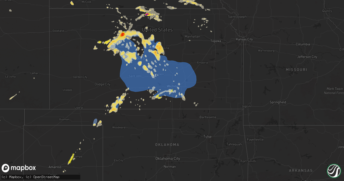
Hail Map on July 21, 2025
Get this storm
July 21 map
$229
one time, instant access
Download today. No call, no setup
Keep the $229
Bought the map and want the full workflow? Apply the entire $229 to a subscription within 7 days. None of it is wasted.
Every map, not just this one
This buys you this map. Subscription and you get every map we run, in the markets you choose from a few cities to whole states to nationwide. Plus real-time alerts the moment a storm fires.
Contact data
Name, contact info, occupancy, even credit band for addresses in the footprint. You go from where it hit to who to call.
Become the source they trust
Unlimited branding weather history reports on demand. You already have the documented answer ready for the property owner, and you are the one who showed up with it.
Property data and RoofTrace estimates
Pull up any address you have got, its value and the exact code rules for that jurisdiction, straight from One Click Code. Then RoofTrace estimates the squares, pitch, and roof value, priced the way you price.
States Impacted by Hail Map on July 21, 2025
Storm reports
Texas
| Date | Description |
|---|---|
| 07/21/20256:29 PM CDT | A local report indicates 58 MPH wind near 1 NNW Lubbock Int. Airp |
| 07/21/20253:25 PM CDT | Thunderstorm winds did damage to a barn roof... With part of the roof removed and hanging off the side. |
| 07/21/202512:09 AM CDT | West texas mesonet. |
| 07/20/202510:48 PM CDT | (lub |
| 07/20/202510:48 PM CDT | A local report indicates 64 MPH wind near Vigo Park |
| 07/20/20257:10 PM CDT | A local report indicates 64 MPH wind near 1 NNW Crane |
Wyoming
| Date | Description |
|---|---|
| 07/21/20254:45 PM CDT | Broken windshield on truck... Damage to siding... Several branches 2 inches to 6 inches in diameter down. |
| 07/21/20254:45 PM CDT | Broken windshield on truck... Damage to siding... Several branches 2 inches to 6 inches in diameter down. |
| 07/21/20254:39 PM CDT | A local report indicates 1.25 inch wind near 11 SSE Weston |
| 07/21/20254:39 PM CDT | A local report indicates 58 MPH wind near 11 SSE Weston |
West Virginia
| Date | Description |
|---|---|
| 07/21/20251:58 PM CDT | Tree fell on power lines in wilcoe... Lines smoking. Time estimated from radar. |
Nebraska
| Date | Description |
|---|---|
| 07/21/20255:22 PM CDT | Hail ranged from half inch to golf ball size. |
Alabama
| Date | Description |
|---|---|
| 07/20/20259:06 PM CDT | Tree down on cr 382. |
North Dakota
| Date | Description |
|---|---|
| 07/21/20251:55 AM CDT | Awos station ky19 mandan. |
| 07/21/20251:46 AM CDT | Report from mping: quarter |
| 07/21/20251:43 AM CDT | Report from mping: quarter |
Kentucky
| Date | Description |
|---|---|
| 07/21/20253:12 PM CDT | Multiple large trees down near intersection of brooklyn chapel and tarvin embry roads. |
Florida
| Date | Description |
|---|---|
| 07/21/20251:45 PM CDT | Power lines down on sebastian harbor drive. Time estimated by radar. |
Kansas
| Date | Description |
|---|---|
| 07/21/20256:44 PM CDT | A local report indicates 60 MPH wind near 1 NNW Tescott |
| 07/21/20256:36 PM CDT | Trained spotter estimated winds of 65 to 70 mph and a large tree limb was knocked down. |
| 07/21/20256:29 PM CDT | Downed powerlines on highway 160 going from the kdot building to about 1.6 miles east. |
| 07/21/20256:26 PM CDT | A local report indicates 1.00 inch wind near 2 SE Collyer |
| 07/21/20256:21 PM CDT | Ambient wind measuring station reported 78 mph gusts. |
| 07/21/20255:42 PM CDT | Emergency management report tree damage just north of protection. |
| 07/21/20255:24 PM CDT | A local report indicates 1.00 inch wind near WaKeeney |
| 07/21/20254:53 PM CDT | Personal weather station reports gust to 68mph. |
| 07/21/20254:26 PM CDT | A local report indicates 1.50 inch wind near Burr Oak |
| 07/21/20254:24 PM CDT | A local report indicates 1.75 inch wind near 5 E Esbon |
| 07/21/20254:01 PM CDT | Sheriff department reports golf ball sized hail on the northwest side of plainville. |
| 07/21/20253:56 PM CDT | Sheriff department reports quarter sized hail northeast of plainville. |
| 07/21/20253:46 PM CDT | Spotter reports penny to quarter sized hail and 50-60mph wind gusts east of plainville. |
| 07/21/20253:40 PM CDT | Trained spotter reports golf ball sized hail east of plainville. |
| 07/20/202511:12 PM CDT | 8 to 10 inch tree limbs reported down as well. |
| 07/20/202511:05 PM CDT | Delayed report. Time estimated by radar. Tree uprooted a laying across the road in tampa. |
| 07/20/202511:05 PM CDT | Delayed report. Time estimated by radar. Picture sent via social media of a couple of 4-inch tree limbs down in marion. |
| 07/20/202511:00 PM CDT | Delayed report. Time estimated by radar. Several trees down across the central portions of the county... Including a tree down on a trailer near hillsboro. |
| 07/20/202511:00 PM CDT | A local report indicates 1.00 inch wind near Haysville |
| 07/20/202510:55 PM CDT | A local report indicates 60 MPH wind near Hillsboro |
| 07/20/202510:32 PM CDT | Measured with a personal weather station. |
| 07/20/202510:25 PM CDT | The caller also noted a few transformers had blown. |
| 07/20/202510:19 PM CDT | Measured on a handheld anemometer. |
| 07/20/202510:16 PM CDT | Multiple 3 inch diameter limbs were snapped. |
| 07/20/202510:07 PM CDT | Measured on a personal weather station. |
| 07/20/20259:53 PM CDT | Nickel to quarter sized hail. |
| 07/20/20259:47 PM CDT | A local report indicates 59 MPH wind near 3 S Pratt |
| 07/20/20259:32 PM CDT | Measured on a personal weather station. |
| 07/20/20259:31 PM CDT | A local report indicates 58 MPH wind near 5 WSW Neola |
| 07/20/20259:21 PM CDT | A local report indicates 58 MPH wind near 3 SSE Frizell |
| 07/20/20259:14 PM CDT | Measured on a personal weather station. |
| 07/20/20258:55 PM CDT | Nickel hail was also reported. |
| 07/20/20258:50 PM CDT | A local report indicates 60 MPH wind near Hoisington |
| 07/20/20258:48 PM CDT | Reports of several downed power lines and a transformer also down. |
| 07/20/20258:47 PM CDT | Also reported power poles and large tree limbs down. |
| 07/20/20258:15 PM CDT | A local report indicates 60 MPH wind near Liebenthal |
| 07/20/20258:02 PM CDT | A local report indicates 65 MPH wind near 6 E Pfeifer |
| 07/20/20257:58 PM CDT | A local report indicates 66 MPH wind near 6 ENE Kanopolis |
| 07/20/20257:54 PM CDT | Reported a semi blown over at mile marker 222 on i-70 from thunderstorm wind gusts. |
| 07/20/20257:45 PM CDT | A local report indicates 60 MPH wind near 5 WSW Glendale |
| 07/20/20257:40 PM CDT | A local report indicates 59 MPH wind near Russell Airport |
| 07/20/20257:35 PM CDT | A local report indicates 63 MPH wind near Ellsworth Airport |
| 07/20/20257:31 PM CDT | A local report indicates 60 MPH wind near 8 SSW Westfall |
| 07/20/20257:22 PM CDT | Reported a 75mph wind gust on i-70 south of westfall. |
| 07/20/20257:13 PM CDT | A mesonet station reported 65 mph gusts. |
| 07/20/20257:00 PM CDT | Social media report of broken windows... Downed trees... And downed power poles. |
New Mexico
| Date | Description |
|---|---|
| 07/21/20255:16 PM CDT | Coop observer reports hail up to quarter size. |
South Dakota
| Date | Description |
|---|---|
| 07/21/20251:30 AM CDT | Snapped the trunk of a 30 ft tall elm tree that was about a foot in diameter. |
| 07/21/20251:30 AM CDT | Snapped the trunk of a 30 ft tall elm tree that was about a foot in diameter. |
| 07/21/20251:30 AM CDT | Snapped the trunk of a |
| 07/21/20251:30 AM CDT | Snapped the tr |
| 07/21/20251:30 AM CDT | Snapped the trunk of a 30 ft tall elm tree that was about a foot in diameter. (u |
| 07/20/202510:45 PM CDT | Corrects previous tstm wnd gst report from 6 nnw lantry. 73 mph wind gust reported from the sd mesonet 6 miles nnw of lantry. |
| 07/20/202510:45 PM CDT | 73 mph wind gust reported from the sd mesonet 6 miles nnw of lantry. |
| 07/20/202510:15 PM CDT | Tree uprooted |
| 07/20/20258:50 PM CDT | A local report indicates 59 MPH wind near 9 SE Mud Butte |
| 07/20/20258:45 PM CDT | A local report indicates 62 MPH wind near 8 SE Mud Butte |
| 07/20/20257:05 PM CDT | A local report indicates 60 MPH wind near 7 W Oglala |
Minnesota
| Date | Description |
|---|---|
| 07/21/20252:52 PM CDT | Time estimated via radar. |
| 07/21/20252:15 PM CDT | Corrects previous hail report from 5 ssw cleveland. Time estimated via radar. |
| 07/21/20252:15 PM CDT | A local report indicates 1.00 inch wind near 3 N Madison Lake |
| 07/21/20251:58 PM CDT | Quarter sized hail near the kwik trip in st peter. |
| 07/21/20251:50 PM CDT | Quarter to golfball size hail. |
| 07/21/20251:20 PM CDT | Many 3 to 4 inch branches down... And one tree down. |
Montana
| Date | Description |
|---|---|
| 07/21/20256:50 PM CDT | A local report indicates 1.00 inch wind near Hedgesville |
| 07/21/20256:00 PM CDT | A local report indicates 78 MPH wind near 6 ENE Lame Deer |
| 07/21/20255:55 PM CDT | A local report indicates 1.75 inch wind near 1 NW Twodot |
| 07/21/202512:54 AM CDT | Mesonet station ggwfp 2.4 e fort peck |
| 07/21/202512:44 AM CDT | Mesonet station kigm8 king coulee. |
| 07/20/202511:30 PM CDT | A local report indicates 1.75 inch wind near 14 N Pompeys Pillar |
| 07/20/202510:00 PM CDT | A local report indicates 1.75 inch wind near 10 NNW Lavina |
| 07/20/20259:16 PM CDT | A local report indicates 2.00 inch wind near Shawmut |
| 07/20/20257:00 PM CDT | Mesonet station mtswc 5.2 w hathaway |
Georgia
| Date | Description |
|---|---|
| 07/21/20255:25 PM CDT | 911 dispatch reported several trees down on roadway at ways temple road. Time estimated by radar. |
| 07/21/20255:25 PM CDT | 911 dispatch reported one tree down on roadway at south coastal highway and montague street. Time estimated by radar. |
| 07/21/20253:55 PM CDT | Delayed report - a photographer posted photos of a likely downburst on monday afternoon along u.s. Highway 441 between pridgen and broxton in coffee county... Ga. The r |
| 07/21/20253:50 PM CDT | Coffee county emergency management reports downed trees and powerlines in the v |
| 07/21/20253:50 PM CDT | Coffee county emergency management reports downed trees and powerlines in the vicinity of pridgen and broxton. Time of damage based on radar data. |
Tennessee
| Date | Description |
|---|---|
| 07/21/20255:30 PM CDT | A downed tree was blocking randall drive. |
| 07/21/20255:25 PM CDT | Numerous branches were blown down in the crieve hall area. |
| 07/21/20255:15 PM CDT | A tree was blown down along new york ave. |
Utah
| Date | Description |
|---|---|
| 07/21/20256:30 PM CDT | Mesonet station utwdk sr-177 at mp 5 kaysville. |
| 07/21/20255:20 PM CDT | Mesonet station utkno i-80 at mp 40 knolls. |
| 07/21/20255:00 PM CDT | Mesonet station dpg17 interstate 80. |
| 07/20/202511:10 PM CDT | Mesonet station pc124 crow mountain. |
| 07/20/202510:03 PM CDT | Mesonet station ucl04 crow mountain. |
| 07/20/20259:50 PM CDT | Mesonet station utnbc i-15 north brigham city. |
| 07/20/20259:37 PM CDT | Awos station kbmc brigham city rgnl airport. |
| 07/20/20259:09 PM CDT | Asos station klgu logan-cache airport. |
| 07/20/20258:50 PM CDT | Mesonet station freut fremont island - miller hill. |
| 07/20/20257:30 PM CDT | Mesonet station utlak sr-68 at mp 15 mosida. |
| 07/20/20257:00 PM CDT | Mesonet station dpg24 w of wildcat. |
Oklahoma
| Date | Description |
|---|---|
| 07/21/20255:15 PM CDT | Third of three severe wind gusts. |
| 07/21/20254:55 PM CDT | Mesonet measured a gust to 60 mph at 1655cdt... Then measured a gust to 71 mph at 1710cdt. |
Cities Impacted by Hail Map on July 21, 2025
- Litchfield, MN
- Hitchcock, SD
- Grove City, MN
- Atwater, MN
- Iroquois, SD
- Willow Lake, SD
- Gibbon, MN
- Fairfax, MN
- Franklin, MN
- Carpenter, SD
- Yale, SD
- Bryant, SD
- De Smet, SD
- Mayetta, KS
- Manhattan, KS
- Erwin, SD
- Lake Preston, SD
- Frankfort, KS
- Beatrice, NE
- Jansen, NE
- Plymouth, NE
- Onaga, KS
- Westmoreland, KS
- Havensville, KS
- Corning, KS
- Blue Springs, NE
- Soldier, KS
- Virginia, NE
- Filley, NE
- Goff, KS
- Liberty, NE
- Burchard, NE
- Pawnee City, NE
- Lewiston, NE
- Alden, IA
- Iowa Falls, IA
- Dows, IA
- Seneca, KS
- Du Bois, NE
- Bern, KS
- Sabetha, KS
- Shickley, NE
- Ong, NE
- Ohiowa, NE
- Strang, NE
- Geneva, NE
- Tobias, NE
- Stewart, MN
- Western, NE
- Hutchinson, MN
- Wilber, NE
- Brownton, MN
- Swanton, NE
- Fairbury, NE
- Glencoe, MN
- New Auburn, MN
- Gaylord, MN
- Arlington, MN
- Branford, FL
- Diller, NE
- Odell, NE
- Le Sueur, MN
- Henderson, MN
- Moriarty, NM
- Gaylord, KS
- Atlantic, NC
- Saint Peter, MN
- Portis, KS
- Palatka, FL
- Green Cove Springs, FL
- Centralia, KS
- Cleveland, MN
- San Simon, AZ
- Stanley, NM
- Edgar, NE
- Lebanon, KS
- Madison Lake, MN
- Esbon, KS
- Burr Oak, KS
- Mankato, KS
- Elysian, MN
- Kilkenny, MN
- Saint Augustine, FL
- Gainesville, GA
- Le Center, MN
- Nelson, NE
- Groom, TX
- Panhandle, TX
- Cromwell, KY
- Horse Branch, KY
- Webber, KS
- Superior, NE
- Oak, NE
- Morgantown, KY
- Glen Saint Mary, FL
- Brandon, FL
- Valrico, FL
- Formoso, KS
- Alexandria, NE
- Bruning, NE
- Yulee, FL
- Jacksonville, FL
- Callahan, FL
- White Deer, TX
- Plainville, KS
- Natoma, KS
- Skellytown, TX
- Deshler, NE
- Hebron, NE
- Waterville, MN
- Courtland, KS
- Fernandina Beach, FL
- Alma, GA
- Myakka City, FL
- Ellis, KS
- North Fort Myers, FL
- Hubbell, NE
- Okeechobee, FL
- Inavale, NE
- Morriston, FL
- Stockton, KS
- Narka, KS
- Mahaska, KS
- Reynolds, NE
- Trinchera, CO
- Gillette, WY
- Rozet, WY
- Ashby, NE
- Woodston, KS
- White Springs, FL
- Lake City, FL
- Ocala, FL
- Weston, WY
- Red Cloud, NE
- Merriman, NE
- Morrowville, KS
- Lorida, FL
- Smith Center, KS
- Moorcroft, WY
- Alton, KS
- Wakeeney, KS
- Cookeville, TN
- Arcadia, FL
- Buffalo, OK
- Bingham, NE
- Laverne, OK
- Stratton, NE
- Ashland, KS
- Lake Placid, FL
- Miami, TX
- Gordon, NE
- Paradise, KS
- White Sulphur Springs, MT
- Coldwater, KS
- Protection, KS
- Ogallah, KS
- Canal Point, FL
- Indiantown, FL
- Garryowen, MT
- Avon Park, FL
- Osborne, KS
- Waldo, KS
- Martinsdale, MT
- Fort Stockton, TX
- Chadron, NE
- Balko, OK
- Follett, TX
- Sheridan, WY
- Rosston, OK
- Cedar, KS
- Busby, MT
- Crow Agency, MT
- Venus, FL
- Broadus, MT
- Luray, KS
- Beaver, OK
- Palco, KS
- Wilmore, KS
- Pampa, TX
- Quinter, KS
- Whitney, NE
- Barnard, KS
- Lincoln, KS
- Quitaque, TX
- Collyer, KS
- Guide Rock, NE
- Turkey, TX
- Decker, MT
- Two Dot, MT
- Haviland, KS
- Lucas, KS
- Harlowton, MT
- Shawmut, MT
- Devils Tower, WY
- Forsyth, MT
- Tuthill, SD
- Martin, SD
- Lame Deer, MT
- Sundance, WY
- Upton, WY
- Glen Elder, KS
- Moore Haven, FL
- Beloit, KS
- Tipton, KS
- Hulett, WY
- Birney, MT
- Clancy, MT
- Lubbock, TX
- Jewell, KS
- Belleville, KS
- Tescott, KS
- Sylvan Grove, KS
- Hunter, KS
- Judith Gap, MT
- Brookville, KS
- Beverly, KS
- Pine Ridge, SD
- Ponderosa, NM
- Norway, KS
- East Helena, MT
- Winston, MT
- Oelrichs, SD
- Townsend, MT
- Los Alamos, NM
- Pena Blanca, NM
- Helena, MT
- Rosebud, MT
- Scandia, KS
- Jamestown, KS
- Higgins, TX
- Salina, KS
- Catharine, KS
- Concordia, KS
- Bronson, FL
- Ryegate, MT
- Hathaway, MT
- Otter, MT
- Spearfish, SD
- Ramah, CO
- Claude, TX
- Volborg, MT
- Miles City, MT
- Minneapolis, KS
- Ellsworth, KS
- Kanopolis, KS
- Wilson, KS
- Ralls, TX
- Saint Onge, SD
- Whitewood, SD
- Russell, KS
- Immokalee, FL
- Woodrow, CO
- Akron, CO
- Hays, KS
- Gorham, KS
- Victoria, KS
- Bunker Hill, KS
- Walker, KS
- Lindsborg, KS
- Dorrance, KS
- Belle Fourche, SD
- Lorraine, KS
- Marquette, KS
- Hoisington, KS
- Olmitz, KS
- Pfeifer, KS
- Otis, KS
- McCracken, KS
- Schoenchen, KS
- Bison, KS
- La Crosse, KS
- Liebenthal, KS
- Rankin, TX
- Midkiff, TX
- Wounded Knee, SD
- Batesland, SD
- Wanblee, SD
- Raynesford, MT
- Geyser, MT
- Falun, KS
- Holyrood, KS
- Geneseo, KS
- Kadoka, SD
- Hobson, MT
- Assaria, KS
- Lamar, CO
- Marathon, TX
- Floydada, TX
- Claflin, KS
- Alva, OK
- Ellinwood, KS
- Chase, KS
- Great Bend, KS
- Raymond, KS
- Albert, KS
- Little River, KS
- Mcpherson, KS
- Windom, KS
- Lyons, KS
- Bushton, KS
- Kiowa, KS
- Hardtner, KS
- Newell, SD
- Philip, SD
- Lake City, KS
- Union Center, SD
- Mud Butte, SD
- Faith, SD
- Midland, SD
- Medicine Lodge, KS
- Rush Center, KS
- Sharon, KS
- Meadow, SD
- Pawnee Rock, KS
- Larned, KS
- St John, KS
- Hudson, KS
- Kingman, KS
- Spivey, KS
- Alden, KS
- Sterling, KS
- Utica, KS
- Murdock, KS
- Gove, KS
- Harper, KS
- Cheney, KS
- Galva, KS
- Norwich, KS
- Attica, KS
- Nickerson, KS
- Hutchinson, KS
- Partridge, KS
- Dupree, SD
- Cunningham, KS
- Howes, SD
- Glade, KS
- Lavina, MT
- Haven, KS
- Mount Hope, KS
- Garden Plain, KS
- Goddard, KS
- Argonia, KS
- Milton, KS
- Danville, KS
- Odessa, TX
- Midland, TX
- Matheson, CO
- Abbyville, KS
- Inman, KS
- Roundup, MT
- Wichita, KS
- Haysville, KS
- Clearwater, KS
- Viola, KS
- Derby, KS
- Kechi, KS
- Greenwich, KS
- Andale, KS
- Colwich, KS
- Maize, KS
- Moundridge, KS
- Zortman, MT
- Park, KS
- Big Timber, MT
- South Hutchinson, KS
- Lamesa, TX
- Odonnell, TX
- Kirwin, KS
- Broadview, MT
- Phillipsburg, KS
- Isabel, SD
- Canton, KS
- Eagle Butte, SD
- Conway Springs, KS
- Newton, KS
- Tahoka, TX
- Whitewater, MT
- Mulvane, KS
- Peck, KS
- Towanda, KS
- Benton, KS
- Andover, KS
- Mcconnell Afb, KS
- Augusta, KS
- Douglass, KS
- Rose Hill, KS
- Shepherd, MT
- Worden, MT
- Whitewater, KS
- Timber Lake, SD
- Lantry, SD
- Elbing, KS
- Peabody, KS
- McLaughlin, SD
- Trail City, SD
- Whitehorse, SD
- Glencross, SD
- Udall, KS
- Belle Plaine, KS
- Malta, MT
- Walton, KS
- Valley Center, KS
- Marion, KS
- Potwin, KS
- Cedar Point, KS
- Burns, KS
- Florence, KS
- Elmdale, KS
- Cottonwood Falls, KS
- Buffalo, SD
- Capitol, MT
- Mayfield, KS
- Rock, KS
- Custer, MT
- Wellington, KS
- Camp Crook, SD
- Kensington, KS
- Winfield, KS
- Ekalaka, MT
- Shallowater, TX
- Burden, KS
- Reva, SD
- Mound City, SD
- Wilsall, MT
- Prairie City, SD
- Ludlow, SD
- Saint Cloud, FL
- Bison, SD
- Abernathy, TX
- Agra, KS
- Cedar Vale, KS
- Fort Yates, ND
- Lodgepole, SD
- Saint Anthony, ND
- Solen, ND
- Logan, KS
- Mandan, ND
- Gettysburg, SD
- Lenora, KS
- Kintyre, ND
- Napoleon, ND
- Alma, NE
- Bismarck, ND
- Beaver City, NE
- Sturgis, SD
- Baldwin, ND
- Sedan, KS
- Damar, KS
- Orleans, NE
- Selby, SD
- Oxford, NE
- Hoven, SD
- Almena, KS
- Edison, NE
- Tolstoy, SD
- Arapahoe, NE
- Mercer, ND
- Turtle Lake, ND
- New Salem, ND
- Bowdle, SD
- Roscoe, SD
- Muleshoe, TX
- Balfour, ND
- Harvey, ND
- Butte, ND
- Onaka, SD
- Portales, NM
- Voltaire, ND
- Oral, SD
- Maddock, ND
- Lemmon, SD
- Ralph, SD
- Wahpeton, ND
- York, ND
- Towner, ND
- Leeds, ND
- Tintah, MN
- Garrison, ND
- Mellette, SD
- Northville, SD
- Ashton, SD
- Springer, NM
- Fergus Falls, MN
- Conde, SD
- Arvilla, ND
- Ryder, ND
- Beulah, ND
- Dunn Center, ND
- Halliday, ND
- Killdeer, ND
- Park Rapids, MN
- Nevis, MN
- Durham, KS
- Roxbury, KS
- Lehigh, KS
- Hillsboro, KS
- Goessel, KS
- Hesston, KS
- Halstead, KS
- Sedgwick, KS
- North Newton, KS
- Pretty Prairie, KS
- Burrton, KS
- Bentley, KS
- Buhler, KS
- Arlington, KS
- Sylvia, KS
- Turon, KS
- Plevna, KS
- Stafford, KS
- Garfield, KS
- Kinsley, KS
- Lewis, KS
- Belpre, KS
- Byers, KS
- Iuka, KS
- Pratt, KS
- Macksville, KS
- Sawyer, KS
- Coats, KS
- Isabel, KS
- Atlanta, KS
- El Dorado, KS
- Leon, KS
- Piedmont, KS
- Cassoday, KS
- Matfield Green, KS
- Rosalia, KS
- Eureka, KS