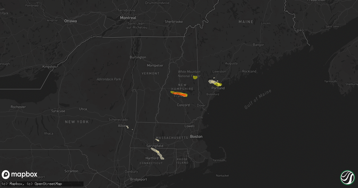
Hail Map on July 20, 2025
Get this storm
July 20 map
$229
one time, instant access
Download today. No call, no setup
Keep the $229
Bought the map and want the full workflow? Apply the entire $229 to a subscription within 7 days. None of it is wasted.
Every map, not just this one
This buys you this map. Subscription and you get every map we run, in the markets you choose from a few cities to whole states to nationwide. Plus real-time alerts the moment a storm fires.
Contact data
Name, contact info, occupancy, even credit band for addresses in the footprint. You go from where it hit to who to call.
Become the source they trust
Unlimited branding weather history reports on demand. You already have the documented answer ready for the property owner, and you are the one who showed up with it.
Property data and RoofTrace estimates
Pull up any address you have got, its value and the exact code rules for that jurisdiction, straight from One Click Code. Then RoofTrace estimates the squares, pitch, and roof value, priced the way you price.
States Impacted by Hail Map on July 20, 2025
Storm reports
Connecticut
| Date | Description |
|---|---|
| 07/20/20256:00 PM CDT | Tree branch down on wires on champion road with the road impassable. |
| 07/20/20256:00 PM CDT | Tree and wires down on ct 87. |
| 07/20/20255:55 PM CDT | Tree limbs down causing a power outage reported by eversource. |
| 07/20/20255:45 PM CDT | Tree downed on wires on pleasant valley rd at mansfield ave in mansfield. Relayed by amateur radio. |
| 07/20/20255:45 PM CDT | Corrects previous tstm wnd dmg report from 2 wnw willimantic ap. Downed powerlines on browns rd in mansfield... With a tree downed on browns rd as well... Which was blo |
| 07/20/20255:05 PM CDT | A tree was downed and a powerline was snapped near ward st in vernon. Relayed by amateur radio. |
| 07/20/20255:00 PM CDT | Tree downed on a car near pinney rd in somers. No injuries. Time estimated by radar. Relayed by amateur radio. |
| 07/20/20255:00 PM CDT | A tree down on wires. Another tree down on a house. |
| 07/20/20254:50 PM CDT | Multiple trees and wires down. |
| 07/20/20254:50 PM CDT | A few trees down on top of wires. |
| 07/20/20254:45 PM CDT | 3 trees downed on powerline wires on bushy hill rd in granby. Relayed by amateur radio. |
Georgia
| Date | Description |
|---|---|
| 07/20/20255:23 PM CDT | Tree and multiple large limbs down in parks ferry campground. |
| 07/20/20255:19 PM CDT | Tree down along parks mill road near alford lane. |
| 07/20/20253:25 PM CDT | Emergency manager reports tree and live wires down at intersection of stiles street and south jackson road. |
| 07/20/20253:20 PM CDT | Emergency manager reports tree down at intersection of highway 24 and franklin road. |
| 07/20/20252:56 PM CDT | Emergency manager reported a tree down at the intersection of metter road and westside road. |
| 07/20/20252:47 PM CDT | Ccso reported a couple trees down and blocking roadways on highway 121 n near hendricks road. |
Virginia
| Date | Description |
|---|---|
| 07/20/20256:35 PM CDT | Tree fell across still house hollow road near saltville... Va... Blocking the entire road. |
| 07/19/20257:33 PM CDT | Tree down blocking part of wassona circle. |
| 07/19/20257:18 PM CDT | Tree down blocking allison gap road. |
Nebraska
| Date | Description |
|---|---|
| 07/20/20255:42 PM CDT | Report from mping: half dollar |
| 07/20/20255:35 PM CDT | A local report indicates 1.75 inch wind near 10 S Nenzel |
| 07/20/20255:26 PM CDT | Report from mping: ping pong ball |
| 07/20/20255:24 PM CDT | Report from mping: ping pong ball |
| 07/20/20255:24 PM CDT | A local report indicates 1.50 inch wind near 7 S Nenzel |
| 07/19/202511:13 PM CDT | Delayed report of multiple trees uprooted. Time estimated by radar. |
| 07/19/20258:53 PM CDT | A local report indicates 1.00 inch wind near 4 WNW Wood Lake |
| 07/19/20258:35 PM CDT | Had 1 inch hail and 54 mph wind gust on his home weather station. |
| 07/19/20258:33 PM CDT | A local report indicates 60 MPH wind near Valentine |
| 07/19/20258:33 PM CDT | A local report indicates 1.00 inch wind near Valentine |
| 07/19/20258:30 PM CDT | A local report indicates 80 MPH wind near 4 NNW Valentine |
| 07/19/20258:29 PM CDT | 60-70 mph winds will the hail. |
| 07/19/20258:25 PM CDT | A local report indicates 1.25 inch wind near 4 N Valentine |
| 07/19/20258:15 PM CDT | Via social media. |
| 07/19/20258:00 PM CDT | Estimated 60 mph winds... Large tree limbs. |
Maine
| Date | Description |
|---|---|
| 07/20/20253:43 PM CDT | Delayed report: multiple trees down in the meicher court and railway avenue area of westbrook. One tree fell into a home. |
| 07/20/20252:05 PM CDT | Report from mping: quarter |
| 07/20/20252:05 PM CDT | Delayed report: large hail stones close too ping pong size fell. |
| 07/20/20252:05 PM CDT | Flat roof partial blown off a building on fundy road. Additional trees down along foreside road. |
| 07/20/20252:00 PM CDT | 1 in hail reported. Patio umbrella with holes and gazebo roof damaged. Time estimated by radar. |
| 07/20/20251:56 PM CDT | Multiple trees down on houses along route 302 in windham... Just in from the westbrook line. |
| 07/20/20251:53 PM CDT | 4 large trees down across mast rd. |
| 07/20/20251:53 PM CDT | Multiple large trees down throughout the area. Tree on a house on canal st in gorham. Another on mosher rd in gorham where a roof came off a house. |
| 07/20/20251:40 PM CDT | Tree on a house on leisure lane. Time estimated by radar. |
| 07/20/20251:40 PM CDT | Tree down on a house on ridge rd. Time estimated by radar. |
| 07/20/20251:38 PM CDT | Spotter sent pictures of large pine tree snapped near base across road and took down wires as well. Time estimated by radar. |
| 07/20/20251:37 PM CDT | Large pine tree down on hanscomb school rd in limington. Time estimated by radar. |
| 07/20/20251:36 PM CDT | Multiple trees down near hanscom school rd in limington. Time estimated by radar. |
| 07/19/20257:39 PM CDT | Delayed report. Garland fire reported tree down on corinth road. |
North Dakota
| Date | Description |
|---|---|
| 07/20/20256:55 PM CDT | Hail for about 10 to 15 minutes. |
| 07/20/20256:30 PM CDT | Heavy rain and widespread hail covering the ground and several vehicles in ditches. Hail ranged from dime to golf ball size. |
| 07/20/20255:52 PM CDT | Hail ongoing at the time of the call. Ground is white with hail. |
| 07/20/20255:48 PM CDT | Hail lasted until 6:05 pm. Broken windows and hail covered much of the ground. |
| 07/20/20255:45 PM CDT | A local report indicates 60 MPH wind near 8 S Fryburg |
| 07/19/20259:38 PM CDT | Many vehicles hydroplaning south of bowman on hwy 85. |
| 07/19/20259:22 PM CDT | Spotter estimated winds of 60 mph and half dollar sized hail. |
| 07/19/20259:18 PM CDT | Relayed through bowman county emergency manager. Ongoing at time of call. |
| 07/19/20259:00 PM CDT | Facebook post. |
| 07/19/20258:55 PM CDT | Peak wind gust measured by private davis weather instrument. |
| 07/19/20258:00 PM CDT | Hail started around 8 pm and was ongoing at the time of the call around 815 pm. |
| 07/19/20257:42 PM CDT | Severe thunderstorm winds were accompanied by large hail. See related hail lsr for more information. |
| 07/19/20257:42 PM CDT | 60 mph winds accompanied the large hail. Wind driven large hail resulted in 3 broken windows and damage to siding. Heavy rain also occurred... 1 - 1.5 inches in 20 minu |
| 07/19/20257:15 PM CDT | Heavy rain and estimated wind gusts to 50 mph. Hail lasted for about 20 minutes. |
Kentucky
| Date | Description |
|---|---|
| 07/20/20256:44 PM CDT | Branches down on kieffer ridge. Photo shared on social media. |
| 07/20/20256:42 PM CDT | Tree down on richardson road and madison pike. Photo on social media. |
| 07/20/20256:40 PM CDT | Reports large branch down at circlewood drive. Possible tornado. Time estimated from radar. |
| 07/20/20254:21 PM CDT | Tree down blocking state route 7 in load. Time estimated from radar. |
| 07/20/20254:21 PM CDT | Tree down blocking state route 7 in load. Time e |
Massachusetts
| Date | Description |
|---|---|
| 07/20/20256:42 PM CDT | Tree and wires down. Another tree down on two cars o |
| 07/20/20256:42 PM CDT | Tree and wires down. Another tree down on two cars on durnell avenue. |
| 07/20/20256:40 PM CDT | Several trees down across town. |
| 07/20/20256:25 PM CDT | Tree down blocking part of a road. |
| 07/20/20256:25 PM CDT | Tree and wires down. |
| 07/20/20256:23 PM CDT | Tree down blocking road near linebrook and haverhill road. |
| 07/20/20256:12 PM CDT | Tree down near on newton street near route 30. |
| 07/20/20256:12 PM CDT | Tree down n |
| 07/20/20256:05 PM CDT | Tree and multiple power lines down. |
| 07/20/20256:05 PM CDT | Tree down blocking road. |
| 07/20/20254:30 PM CDT | Several trees downs in belchertown near turkey hill road... Chauncey walker street... Summir street... And shaw road |
| 07/20/20253:45 PM CDT | Tree down on wires blocking road - washington mountain rd. |
| 07/20/20253:39 PM CDT | A couple of trees and a large branch were downed near lee in |
| 07/20/20253:39 PM CDT | A couple of trees and a large branch were downed near lee including on prospect street... William parkway and on the massachusetts turnpike westbound. |
| 07/19/20257:03 PM CDT | Tree down. |
| 07/19/20257:00 PM CDT | Tree downed on wires near whiting st in hingham. Relayed by amateur radio. |
Alabama
| Date | Description |
|---|---|
| 07/20/20253:33 PM CDT | Tree down blocking south bound lane of roadway. Time estimated based on radar. |
| 07/20/20253:32 PM CDT | Tree down in roadway causing full blockage. |
| 07/20/20253:27 PM CDT | Tree down across cr 86. Time estimated from radar. |
Colorado
| Date | Description |
|---|---|
| 07/20/202512:16 AM CDT | Site kemp well service measured 62 mph wind gust. |
Indiana
| Date | Description |
|---|---|
| 07/19/20257:55 PM CDT | Trees down. |
West Virginia
| Date | Description |
|---|---|
| 07/20/20256:45 PM CDT | Small streams starting to flood in the east lynn area. Photos provided... One of which shows part of a garden flooding. |
| 07/20/20255:37 PM CDT | Tree down. Time estimated from radar. |
| 07/20/20255:35 PM CDT | Tree and power lines down. Time estimated from radar. |
| 07/20/20255:27 PM CDT | Tree damage resulting in 591 customers without power. |
| 07/20/20255:25 PM CDT | Tree and lines down blocking jones branch road in jeffrey. Time estimated from radar. |
| 07/20/20255:22 PM CDT | Tree damage resulting in 40 customers without power. |
| 07/20/20255:15 PM CDT | Tree down blocking roadway. |
| 07/20/20254:23 PM CDT | Tree down blocking one lane of camp creek road. Time estimated from radar. |
New York
| Date | Description |
|---|---|
| 07/20/20253:12 PM CDT | Downed tree across road at route 22 and provost rd. |
| 07/20/20253:05 PM CDT | Tree and wires down near new york route 203 and alter alley way in nassau. |
| 07/20/20252:24 PM CDT | Pole and wires down in woods. |
| 07/20/20252:00 PM CDT | Downed tree and wires in pattersonville. |
| 07/20/20251:44 PM CDT | Downed tree. |
| 07/20/20251:42 PM CDT | Downed tree. |
Vermont
| Date | Description |
|---|---|
| 07/20/20254:00 PM CDT | Downed tree on house in saxtons river. |
South Dakota
| Date | Description |
|---|---|
| 07/20/20256:45 PM CDT | Most baseball size. |
| 07/20/20256:40 PM CDT | A local report indicates 1.00 inch wind near 2 N Parmelee |
| 07/20/20256:33 PM CDT | A local report indicates a tornado near 1 NW Parmelee |
| 07/20/20253:52 PM CDT | A trained weather spotter reported 4 inch tree branches down off a cottonwood tree. |
| 07/20/20253:36 PM CDT | Trained spotter estimated between 50-60 mph winds. Time estimated via radar. |
| 07/20/20253:33 PM CDT | Reports of a camper blown over as well as several trees blown onto powerlines. Report via social media. |
| 07/20/20253:22 PM CDT | A local report indicates 60 MPH wind near 4 NNE Letcher |
| 07/20/20253:05 PM CDT | Reports of numerous tree damage across the city of woonsocket. |
| 07/20/20253:05 PM CDT | A local report indicates 1.00 inch wind near Woonsocket |
| 07/20/20253:05 PM CDT | Social media related report of numerous tree and branch damage across the town. Sides blown in on an empty grain bin. Grain truck tipped over. Partial roof damage to sh |
| 07/20/20253:04 PM CDT | Relayed report from social media. |
| 07/20/20253:00 PM CDT | Mesonet station wsms2 woonsocket 4nnw. |
| 07/20/20252:49 PM CDT | Mesonet station 305 sd rwis lane. |
| 07/20/20252:44 PM CDT | Blown out attached garage and outbuilding. Time estimated from radar. |
| 07/20/20252:44 PM CDT | Mesonet station 305 sd rwis lane. |
| 07/20/20252:42 PM CDT | Damaged outbuilding and hoop barn. Time estimated from radar. |
| 07/20/20252:33 PM CDT | Corrects previous tstm wnd dmg report from 4 nnw lane. Reports of a camper blown over as well as several trees blown onto powerlines. Report via social media. |
| 07/20/20252:00 PM CDT | Reported via facebook. 2 inch diameter tree branches down. Time estimated from radar. |
| 07/20/20252:00 PM CDT | Mesonet station rhus2 danforth 5 e... Time estimated from radar. |
| 07/20/20254:15 AM CDT | A few tree branches down and spotter estimates 60+ mph winds. Radar estimated time. |
| 07/20/20253:45 AM CDT | Mesonet station 2 lake city |
| 07/20/20252:57 AM CDT | Personal weather station 2 miles ene aberdeen measured 62 mph peak wind gust. Exa |
| 07/20/20252:57 AM CDT | Personal weather |
| 07/20/20252:57 AM CDT | Personal weather station 2 miles ene aberdeen measured 62 |
| 07/20/20252:57 AM CDT | Personal weather station 2 miles ene aberdeen measured 62 mph peak wind gust. Exact time estimated by radar. |
| 07/20/20251:49 AM CDT | Public comment on facebook of dime to quarter sized hail along with high winds producing some light damage. Time estimated by radar. |
| 07/20/20251:49 AM CDT | Public comment on |
| 07/20/202512:40 AM CDT | Had some wheat lodged or bent over by the wind. |
| 07/19/20259:55 PM CDT | Most was smaller |
| 07/19/20258:01 PM CDT | Estimated 2.5 inch hailstone. Mostly quarter size and small. No damage reported. |
| 07/19/20257:55 PM CDT | A local report indicates 1.25 inch wind near 7 N Belvidere |
| 07/19/20257:50 PM CDT | A local report indicates 1.75 inch wind near 7 ESE Saint Francis |
| 07/19/20257:45 PM CDT | Updated location. 8 sse of tuthill was the incorrect location. |
| 07/19/20257:45 PM CDT | A local report indicates 70 MPH wind near 8 SSE Tuthill |
| 07/19/20257:45 PM CDT | (u |
| 07/19/20257:43 PM CDT | Most quarter size. Been hailing for 15 minutes and still hailing. |
| 07/19/20257:15 PM CDT | A local report indicates 4.50 inch wind near Rosebud |
| 07/19/20257:14 PM CDT | A local report indicates 2.75 inch wind near Rosebud |
| 07/19/20257:04 PM CDT | A local report indicates 2.50 inch wind near 5 NW Saint Francis |
Kansas
| Date | Description |
|---|---|
| 07/20/20256:31 AM CDT | Delayed report: 1/3 of shop roof was blow off and over the house. |
| 07/20/20256:31 AM CDT | Delayed r |
| 07/20/20256:31 AM CDT | Delayed report: 1/3 of shop roof was blow off and over the house. The houses ga |
| 07/20/20256:31 AM CDT | Delayed report: 1/3 of |
| 07/20/20256:31 AM CDT | Delayed report: 1/3 of shop roof was blow off and over the house. The houses garage door was blown into the garage. A basketball goal with cement footing was blown over |
Illinois
| Date | Description |
|---|---|
| 07/20/20256:24 PM CDT | Delayed report. Large tree down on north park road near lake sara. |
| 07/20/20256:06 PM CDT | Delayed report. Large tree limb down on power lines. |
| 07/20/20255:56 PM CDT | Delayed report. A few 6 inch diameter tree limbs down. |
| 07/20/20254:47 PM CDT | Delayed report. Shingles blown off a few homes. Corn flattened on the south edge of town. |
| 07/19/20257:01 PM CDT | 3 large trees uprooted near leaverton park. |
North Carolina
| Date | Description |
|---|---|
| 07/20/20256:45 PM CDT | Tree down near the intersection of hamburg street and welcome baptist church road near mount airy... Nc. Time is estimated from radar. |
| 07/20/20256:43 PM CDT | Massive oak tree down across robin road. |
| 07/19/20259:00 PM CDT | Tree and power line down near the intersection of south holden road and west vandalia road. |
| 07/19/20259:00 PM CDT | Tree and power line down near the |
| 07/19/20259:00 PM CDT | Tree and power line down along cypress park road. |
| 07/19/20258:09 PM CDT | A couple trees and a power line down along pacific drive. |
| 07/19/20258:05 PM CDT | Tree down along glenwood street. |
Ohio
| Date | Description |
|---|---|
| 07/20/20255:29 PM CDT | Tree down along county road 411. Lines in tree and hanging low over the roadway. Time estimated from radar. |
| 07/20/20254:55 PM CDT | Tree hanging in roadway on state route 775. |
| 07/20/20254:20 PM CDT | Tree down on state route 650 near blocking one lane. Time estimated from radar. |
| 07/20/20253:06 PM CDT | Tree down on power line at fossil rock road and sargent road in guysville. Power line was smoking. Time estimated from radar. |
| 07/20/20252:37 PM CDT | Power line down near pretty run road and garrett ridge road. Time estimated from radar. |
| 07/20/20252:35 PM CDT | Tree down on diamond brick road. Time estimated from radar. |
| 07/20/20252:34 PM CDT | Tree down along macedonia road in eagle township. Time estimated from radar. |
Montana
| Date | Description |
|---|---|
| 07/20/20256:50 PM CDT | Asos station kmls miles city. |
| 07/20/20254:48 PM CDT | A local report indicates 71 MPH wind near 2 WNW Jordan |
| 07/19/202510:04 PM CDT | A local report indicates 1.00 inch wind near 1 N Broadus |
| 07/19/202510:04 PM CDT | A local report indicates 1.50 inch wind near 4 NE Broadus |
| 07/19/202510:00 PM CDT | Mesonet station mtm32 2.4 e broadus |
| 07/19/20259:54 PM CDT | Large tree |
| 07/19/20259:53 PM CDT | A local report indicates 1.00 inch wind near 2 SW Olive |
| 07/19/20259:40 PM CDT | A local report indicates 60 MPH wind near 1 N Epsie |
| 07/19/20259:23 PM CDT | Tree damage reported with estimated maximum branch diameter of 5 inches. |
| 07/19/20259:05 PM CDT | A local report indicates 70 MPH wind near 4 N Webster |
| 07/19/20258:34 PM CDT | A local report indicates 1.00 inch wind near 4 W Baker |
| 07/19/20257:45 PM CDT | Report from mping: ping pong ball |
| 07/19/20257:34 PM CDT | Blowing debris caused car damage at campground. |
| 07/19/20257:24 PM CDT | Report from mping: quarter |
| 07/19/20257:20 PM CDT | Lots of rain with hail up to quarter size. |
| 07/19/20257:20 PM CDT | Big horn county airport. |
| 07/19/20257:02 PM CDT | Spotter reports their screen door was completely ripped off its hinges. |
New Hampshire
| Date | Description |
|---|---|
| 07/20/20255:44 PM CDT | Reported by weather spotter. Large tree partially blocking musguash road. Time estimated by radar. |
| 07/20/20255:26 PM CDT | Reported by weather spotter. Large tree crushed a garage. Time estimated by radar. |
| 07/20/20254:30 PM CDT | Report of a large tree crushing a parked car on sawtooth rd. |
| 07/20/20254:23 PM CDT | Corrects previous hail report from 4 se laconia. Reported by weather spotter. |
| 07/20/20254:22 PM CDT | A local report indicates 1.50 inch wind near 1 NE Belmont |
| 07/20/20254:21 PM CDT | Reported by weather spotter. |
| 07/20/20254:20 PM CDT | Half dollar size hail for about 7-8 minutes. |
| 07/20/20254:17 PM CDT | Observed trees and branches down on morin rd as well as nh highway 107. Time estimated by radar. |
| 07/20/20254:10 PM CDT | Report of 1.5 in hail shattering car wind shield. |
| 07/20/20254:10 PM CDT | Reported by amateur radio. |
| 07/20/20254:10 PM CDT | Spotter reported a large tree down blocking road-intersection of grange st and lancaster hill rd. Time est. By radar. |
| 07/20/20254:05 PM CDT | Dispatch reported trees and wires down on a home in franklin. Time estimated by radar. |
| 07/20/20254:02 PM CDT | Tree down on interstate 93 northbound... Blocking one lane. Time estimated by radar. |
| 07/20/20254:00 PM CDT | Tree down on house. Fire dept. Dispatched. Time estimated by radar. |
| 07/20/20254:00 PM CDT | Extensive tree damage in sanbornton that blocked multiple roads along with downed powerlines and wires. Trees on homes and vehicles. |
| 07/20/202512:55 PM CDT | A local report indicates 1.00 inch wind near 4 NE Eaton |
| 07/20/202512:52 PM CDT | Reported by amateur radio. |
Cities Impacted by Hail Map on July 20, 2025
- McDonald, KS
- Bird City, KS
- Atwood, KS
- Weskan, KS
- Sharon Springs, KS
- Stockton, KS
- Plainville, KS
- Natoma, KS
- Gray, ME
- Cumberland Center, ME
- Windham, ME
- Falmouth, ME
- Westbrook, ME
- Portland, ME
- Cumberland Foreside, ME
- Yarmouth, ME
- Chebeague Island, ME
- Wessington Springs, SD
- Alpena, SD
- Woonsocket, SD
- Artesian, SD
- Letcher, SD
- Wessington, SD
- Mitchell, SD
- Fulton, SD
- Jordan, MT
- Orlando, FL
- Christmas, FL
- Medora, ND
- White River, SD
- Cody, NE
- Kilgore, NE
- Nenzel, NE
- Belfield, ND
- Norris, SD
- South Heart, ND
- Flagler, CO
- Dickinson, ND
- New England, ND
- Valentine, NE
- Kinsey, MT
- Miles City, MT
- Ismay, MT
- Terry, MT
- Lefor, ND
- Parmelee, SD
- Gladstone, ND
- Saint Francis, SD
- Fallon, MT
- Regent, ND
- Rosebud, SD
- Joes, CO
- Cope, CO
- Bowman, ND
- Amidon, ND
- Mott, ND
- Midland, SD
- Belvidere, SD
- Kadoka, SD
- Mission, SD
- Crookston, NE
- Saint Francis, KS
- Garryowen, MT
- Lodge Grass, MT
- Golva, ND
- Sentinel Butte, ND
- Beach, ND
- Long Valley, SD
- Wood Lake, NE
- Baker, MT
- Plevna, MT
- Mandan, ND
- Rhame, ND
- Camp Crook, SD
- Thedford, NE
- Johnstown, NE
- Buffalo, SD
- Otter, MT
- Olive, MT
- Broadus, MT
- Hugo, CO
- Biddle, MT
- Reeder, ND
- Scranton, ND
- Hettinger, ND
- Moffit, ND
- Ainsworth, NE
- Boyes, MT
- Hammond, MT
- Alzada, MT
- Haswell, CO
- Eads, CO
- Center Conway, NH
- Conway, NH
- Madison, NH
- Grafton, NH
- Springfield, NH
- Danbury, NH
- Wilmot, NH
- Hill, NH
- Franklin, NH
- Sanbornton, NH
- Andover, NH
- Tilton, NH
- Belmont, NH
- Laconia, NH
- Gilford, NH
- Gilmanton, NH
- Grenville, SD
- Langford, SD
- Sisseton, SD
- Eden, SD
- Pierpont, SD
- Lake City, SD
- Peever, SD
- Roslyn, SD
- Veblen, SD
- Bath, SD
- Columbia, SD
- Andover, SD
- Ipswich, SD
- Groton, SD
- Aberdeen, SD
- Westport, SD
- Roscoe, SD
- Claremont, SD
- Britton, SD
- Amherst, SD
- Bristol, SD
- Webster, SD
- New Effington, SD
- Claire City, SD
- Wilmot, SD
- Summit, SD
- Waubay, SD
- Ortley, SD
- Beardsley, MN
- Rosholt, SD
- Browns Valley, MN
- Bismarck, ND
- Fort Pierre, SD
- Hayes, SD
- Onarga, IL
- Gilman, IL
- McIntosh, SD
- McLaughlin, SD
- Keldron, SD
- Lemmon, SD
- Morristown, SD
- Thawville, IL
- Wingate, IN
- Westpoint, IN
- Attica, IN
- Cissna Park, IL
- Milford, IL
- Eagle Butte, SD
- Virgil, SD
- Watauga, SD
- Holabird, SD
- Ree Heights, SD
- Highmore, SD
- Alexandria, SD
- Fedora, SD
- Lakewood, IL
- Shelbyville, IL
- Lewistown, MT
- Saint Lawrence, SD
- Miller, SD
- Saint Petersburg, FL
- Crescent City, IL
- Canova, SD
- Spencer, SD
- Suffield, CT
- Greenfield, IA
- Stuart, IA
- Harrold, SD
- West Union, IL
- Pana, IL
- Cowden, IL
- Oconee, IL
- Tower Hill, IL
- Standish, ME
- Gorham, ME
- Raymond, ME
- New Richmond, IN
- Crawfordsville, IN
- Sullivan, IN
- Rapid City, SD
- Stephentown, NY
- Broad Brook, CT
- Tolland, CT
- Ellington, CT
- Enfield, CT
- Molt, MT
- Broadview, MT
- Mora, NM
- Wibaux, MT
- Granby, MA
- Belchertown, MA
- Fort Stockton, TX
- Tampa, FL
- Kirk, CO
- Vona, CO
- Newton, IL
- North Yarmouth, ME
- Bloomington, IN
- Gilmanton Iron Works, NH
- Las Animas, CO
- Buckhead, GA
- Decker, MT
- Howard, SD
- Salem, SD
- Nassau, NY
- Averill Park, NY
- East Greenbush, NY
- West Sand Lake, NY
- New Salem, ND
- Cohagen, MT
- Farmersburg, IN
- Shelburn, IN
- Effingham, IL
- Lawrenceville, IL
- Bingham, IL
- Nokomis, IL
- Ramsey, IL
- Herrick, IL
- Brownstown, IL
- Vandalia, IL
- Ekalaka, MT
- Lame Deer, MT
- Busby, MT
- Gettysburg, SD
- Clewiston, FL
- Hutsonville, IL
- West York, IL
- Grenville, NM
- Vernon Rockville, CT
- Somers, CT
- Center, ND
- Yoder, CO
- Marshall, IL
- Terre Haute, IN
- Sigel, IL
- Stewardson, IL
- Shumway, IL
- Beecher City, IL
- Altamont, IL
- Farmersville, IL
- Harvel, IL
- Morrisonville, IL
- Louisville, IL
- Mason, IL
- Dieterich, IL
- Ingraham, IL
- Lambert, MT
- Fairbanks, IN
- Assumption, IL
- Florence, KY
- Erlanger, KY
- Seibert, CO
- Hidalgo, IL
- Fillmore, IL
- Melville, MT
- Birney, MT
- Ashland, MT
- Hardin, MT
- Ludlow, SD
- Stratton, CO
- Kit Carson, CO
- Bridgeport, IL
- Zolfo Springs, FL
- Wauchula, FL
- Menoken, ND
- Sterling, ND
- Driscoll, ND
- Raymond, IL
- Mansfield Center, CT
- Feeding Hills, MA
- Columbia, CT
- Andover, CT
- Coventry, CT
- Storrs Mansfield, CT
- East Windsor, CT
- West Suffield, CT
- Lodgepole, SD
- Alamo, ND
- Rosamond, IL
- Teutopolis, IL
- Madison, GA
- Tappen, ND
- Wagon Mound, NM
- Fairview, MT
- Westby, MT
- Bullhead, SD
- Reva, SD
- Boone, CO
- Karval, CO
- Ordway, CO
- Rush, CO
- Fontanelle, IA
- Ralph, SD
- Trail City, SD
- Meadow, SD
- Osgood, IN
- Moweaqua, IL
- Macon, IL
- Bassett, NE
- Burwell, NE
- Cheyenne Wells, CO
- Braddock, ND
- Mobridge, SD
- Kintyre, ND
- Gackle, ND
- Napoleon, ND
- Nebo, IL
- Streeter, ND
- Paris, MO
- Java, SD
- Bowdle, SD
- Selby, SD
- West Liberty, IL
- Willow Hill, IL
- Elsberry, MO
- Annada, MO
- Long Pine, NE
- Hoven, SD
- Witt, IL
- Mulberry Grove, IL
- Mound City, SD
- Mode, IL
- Jud, ND
- Eureka, SD
- Glenham, SD
- Herreid, SD
- Edgeley, ND
- Burlington, CO
- Akaska, SD
- Berlin, ND
- Fullerton, ND
- Dickey, ND
- Lamoure, ND
- Oakes, ND
- Cogswell, ND
- Havana, ND
- Leola, SD
- Kampsville, IL
- Forman, ND
- Rutland, ND
- Cayuga, ND
- Benson, MN
- Milbank, SD
- Labolt, SD
- Barry, MN
- Graceville, MN
- Stockholm, SD
- Stickney, SD
- Kandiyohi, MN
- Willmar, MN
- Montevideo, MN
- Appleton, MN
- Milan, MN
- Danvers, MN
- Murdock, MN
- Raymond, MN
- Clara City, MN
- Maynard, MN
- Hosmer, SD
- Madison, MN
- Dumont, MN
- Salisbury, MO
- Bellingham, MN
- Strandburg, SD
- Revillo, SD
- Watseka, IL
- Des Moines, IA
- Blue Mound, IL
- Tolstoy, SD
- Litchfield, IL
- Watson, MN
- Dawson, MN
- Kerkhoven, MN
- Denver, MO
- Martinsville, MO
- Pennock, MN
- Bethune, CO
- Arapahoe, CO
- Crow Agency, MT
- Marmarth, ND