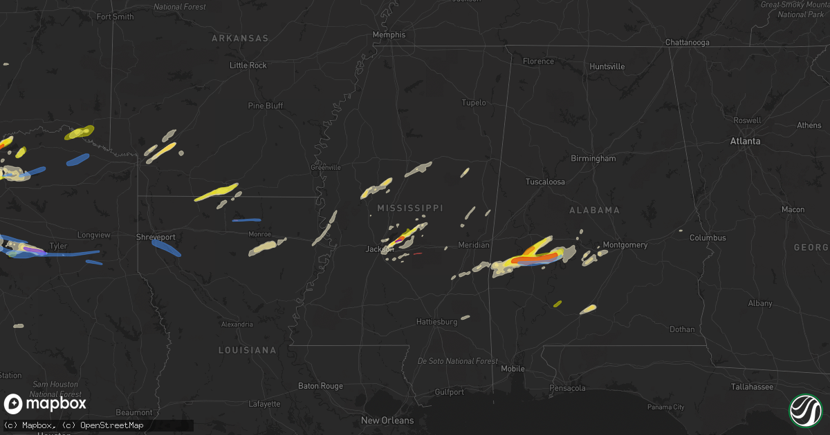
Hail Map in Mississippi on April 4, 2022
Get this storm
April 4 map
$229
one time, instant access
Download today. No call, no setup
Keep the $229
Bought the map and want the full workflow? Apply the entire $229 to a subscription within 7 days. None of it is wasted.
Every map, not just this one
This buys you this map. Subscription and you get every map we run, in the markets you choose from a few cities to whole states to nationwide. Plus real-time alerts the moment a storm fires.
Contact data
Name, contact info, occupancy, even credit band for addresses in the footprint. You go from where it hit to who to call.
Become the source they trust
Unlimited branding weather history reports on demand. You already have the documented answer ready for the property owner, and you are the one who showed up with it.
Property data and RoofTrace estimates
Pull up any address you have got, its value and the exact code rules for that jurisdiction, straight from One Click Code. Then RoofTrace estimates the squares, pitch, and roof value, priced the way you price.
Storm reports in Mississippi
Mississippi
| Date | Description |
|---|---|
| 04/04/20226:51 AM CDT | Trees and power lines down along hwy 481 just north of the smith county line. Tds also noted on radar. |
| 04/04/20226:45 AM CDT | 2 large oak trees down on hwy 28 near pinola. |
| 04/04/20226:35 AM CDT | Corrects previous tstm wnd dmg report from 1 wsw bude. Tree down across hwy 98. |
| 04/04/20226:35 AM CDT | Numerous trees down... With some down on power lines... In the city of brookhaven. |
| 04/04/20226:25 AM CDT | Picture of a fence blown down at a home in byram. |
| 04/04/20226:23 AM CDT | Tree down on power lines on gary rd near red oak cove. |
| 04/04/20226:15 AM CDT | Trees and power lines down in the union church area. |
| 04/04/20226:14 AM CDT | Tree down with power lines blocking one lane of traffic on springridge rd near big creek rd. |
| 04/04/20226:13 AM CDT | Tree down in clinton. |
| 04/04/20226:10 AM CDT | A few trees down. |
| 04/04/20225:55 AM CDT | Trees down in the church hill area. |
| 04/04/20225:53 AM CDT | Trees reported down in the edwards area. |
| 04/04/20225:50 AM CDT | Scattered trees down. |
| 04/04/20225:45 AM CDT | Scattered trees down in the county. |
| 04/04/20225:36 AM CDT | Tree down along hwy 61 in redwood. |
| 04/04/20225:14 AM CDT | Social media report of nickel to quarter size hail near crystal springs. Time and location estimated with radar. |
| 04/04/20225:01 AM CDT | At 1000 PM CDT, a severe thunderstorm was located near Slidell, moving northeast at 30 mph. HAZARD...60 mph wind gusts and quarter size hail. SOURCE...Radar indicated. IMPACT...Hail damage to vehicles is expected. Expect wind damage to roofs, siding, and trees. Locations impacted include... Slidell and Pearlington. This includes Interstate 10 in Louisiana between mile markers 261 and273. |
| 04/04/20224:51 AM CDT | Dime to quarter size hail covering the parking lot of a gas station in stewart. |
| 04/04/20223:34 AM CDT | Hail to the size of quarters reported in lena. |
| 04/04/20223:30 AM CDT | Ping pong ball sized hail. |
| 04/04/20223:09 AM CDT | Hail to the size of golf balls fell along stump ridge road. |
| 04/04/20223:05 AM CDT | Hail to the size of golf balls fell in the bay pointe neighborhood. Report with picture relayed via twitter. |
| 04/04/20223:05 AM CDT | Hail measured at 2.1 inches fell along holly bush road near the mcclain lodge area. Report with picture relayed via twitter. |
| 04/04/20222:59 AM CDT | Hail measured at 1.50 inches fell near the intersection of hwy 471 and spillway rd. Report with picture relayed via twitter. |
| 04/04/20222:59 AM CDT | At least golf ball hail reported along hugh ward blvd. |
All States Impacted by Hail Map on April 4, 2022
Cities Impacted by Hail Map on April 4, 2022
- Ravenna, TX
- Bonham, TX
- Ivanhoe, TX
- Savoy, TX
- Telephone, TX
- Fletcher, OK
- Rush Springs, OK
- Bradley, OK
- Ninnekah, OK
- Wolfe City, TX
- Gordon, TX
- Stephenville, TX
- Mingus, TX
- Coppell, TX
- Irving, TX
- Dallas, TX
- Carrollton, TX
- Burleson, TX
- De Kalb, MS
- Preston, MS
- Avon Park, FL
- Sebring, FL
- Frostproof, FL
- Del Rio, TX
- Hayneville, AL
- Brandon, MS
- Sardis, AL
- Minter, AL
- Tyler, AL
- Evergreen, AL
- McKenzie, AL
- Fulton, AR
- Ennis, TX
- Waxahachie, TX
- Palmer, TX
- Flower Mound, TX
- Punta Gorda, FL
- Sylvester, TX
- McCaulley, TX
- Roby, TX
- Alva, FL
- Labelle, FL
- Immokalee, FL
- Fort Myers, FL
- Lehigh Acres, FL
- Clewiston, FL
- Quitman, MS
- Venus, TX
- Weatherford, TX
- Lillian, TX
- Alvarado, TX
- Fort Worth, TX
- Joshua, TX
- Cleburne, TX
- Mansfield, TX
- Crowley, TX
- Cresson, TX
- Godley, TX
- Flowood, MS
- Pelahatchie, MS
- Morton, MS
- Desdemona, TX
- Ranger, TX
- Dublin, TX
- Meridian, TX
- Clifton, TX
- Silver City, MS
- Collinsville, MS
- Texarkana, AR
- Emmet, AR
- Hope, AR
- Zolfo Springs, FL
- Lake Wales, FL
- River Ranch, FL
- Kenansville, FL
- Toxey, AL
- Butler, AL
- Grandview, TX
- Lewisville, TX
- Wanette, OK
- Yazoo City, MS
- Belzoni, MS
- Tchula, MS
- Newark, TX
- Honey Grove, TX
- Arcadia, FL
- Wayne, OK
- Maysville, OK
- Maypearl, TX
- Breckenridge, TX
- Caddo, TX
- Kilmichael, MS
- Sweet Water, AL
- Uniontown, AL
- Dixons Mills, AL
- Arlington, AL
- Safford, AL
- Linden, AL
- Pine Hill, AL
- Thomaston, AL
- Faunsdale, AL
- Pennington, AL
- Catherine, AL
- Alberta, AL
- Magnolia, AL
- Celeste, TX
- Leonard, TX
- Waurika, OK
- Ringling, OK
- Strawn, TX
- Palo Pinto, TX
- Lowndesboro, AL
- Selma, AL
- Justin, TX
- Paradise, TX
- Springtown, TX
- Boyd, TX
- Decatur, TX
- Ponder, TX
- Bridgeport, TX
- Rhome, TX
- Nocona, TX
- Saint Jo, TX
- Fort Lauderdale, FL
- Paducah, TX
- Lone Grove, OK
- Healdton, OK
- Wilson, OK
- Ardmore, OK
- Grapevine, TX
- Southlake, TX
- Seymour, TX
- Shubuta, MS
- Blue Ridge, TX
- Farmersville, TX
- Holliday, TX
- Olney, TX
- Albany, TX
- Eustace, TX
- Mabank, TX
- Clarksville, TX
- Idabel, OK
- Valliant, OK
- Garvin, OK
- Tolar, TX
- Bluff Dale, TX
- Lipan, TX
- Lawton, OK
- Faxon, OK
- Athens, TX
- Murchison, TX
- Malakoff, TX
- Larue, TX
- Brownsboro, TX
- Chandler, TX
- Elgin, OK
- Lena, MS
- Needham, AL
- Thomasville, AL
- Orrville, AL
- Gilbertown, AL
- Scurry, TX
- Kemp, TX
- Ferris, TX
- Granbury, TX
- Italy, TX
- Milford, TX
- Itasca, TX
- Sherman, TX
- Denison, TX
- Bells, TX
- Carthage, MS
- Kaufman, TX
- Rosser, TX
- Ochopee, FL
- Madison, MS
- Ridgeland, MS
- Jackson, MS
- Canton, MS
- Mangham, LA
- Monroe, LA
- Columbia, LA
- West Monroe, LA
- Rayville, LA
- Commerce, TX
- Graford, TX
- Duncan, OK
- Junction City, AR
- El Dorado, AR
- Mayersville, MS
- Sondheimer, LA
- Vicksburg, MS
- Tallulah, LA
- Lexington, MS
- Cruger, MS
- Weinert, TX
- Little Elm, TX
- Midlothian, TX
- Wauchula, FL
- Denton, TX
- Argyle, TX
- Poolville, TX
- Starkville, MS
- Lindsay, OK
- Purcell, OK
- Paoli, OK
- Knox City, TX
- Roanoke, TX
- Trinidad, TX
- Aubrey, TX
- Red Oak, TX
- Richton, MS
- Muenster, TX
- Krum, TX
- Sanger, TX
- Strong, AR
- Haynesville, LA
- Monroeville, AL
- Rolling Fork, MS
- Naples, FL
- Anson, TX
- Lexington, OK
- Marion Junction, AL
- Lisman, AL
- Newton, MS
- Sweetwater, TX
- Santo, TX
- Euless, TX
- Haslet, TX
- Lake Dallas, TX
- Keller, TX
- Bedford, TX
- Chico, TX
- Colleyville, TX
- The Colony, TX
- Addison, TX
- Hurst, TX
- Alvord, TX
- Richardson, TX
- North Richland Hills, TX
- Cary, MS
- Melissa, TX
- Anna, TX
- Blevins, AR
- Prescott, AR
- Myakka City, FL
- Florence, MS
- Forreston, TX
- Chatfield, TX
- Haltom City, TX
- Keene, TX
- Aledo, TX
- Arlington, TX
- Kennedale, TX
- Pachuta, MS
- Vossburg, MS
- Dodd City, TX
- Vaiden, MS
- Stewart, MS
- Ladonia, TX
- Klondike, TX
- Princeton, TX
- Pahokee, FL
- South Bay, FL
- Mckinney, TX
- Cumby, TX
- Sulphur Springs, TX
- Greenville, TX
- Van Alstyne, TX
- Venus, FL
- Auburn, AL
- Opelika, AL
- Bagwell, TX
- Stamford, TX
- Windom, TX
- Forest, MS
- Heidelberg, MS
- Frisco City, AL
- Peterman, AL
- Sturgis, MS
- Louisville, MS
- Miami, FL
- Port Charlotte, FL
- Rosston, AR
- Centerville, TX
- Ogden, AR
- Apache, OK
- Jayton, TX
- Moore Haven, FL
- Plano, TX
- Homestead, FL
- French Camp, MS
- Eupora, MS
- Newcastle, TX
- Coalgate, OK
- Stuart, OK
- Randlett, OK
- Scooba, MS
- Cement, OK
- Walnut Grove, MS
- Fort Meade, FL
- Spearsville, LA
- Bernice, LA
- Lillie, LA
- Richland, MS
- Pearl, MS
- Ryan, OK
- Montague, TX
- Bentonia, MS
- Broken Bow, OK
- Coushatta, LA
- Ringgold, LA
- Shreveport, LA
- Frierson, LA
- Keithville, LA
- Elm Grove, LA
- Downsville, LA
- Choudrant, LA
- Sterlington, LA
- Farmerville, LA
- Windthorst, TX
- Cooper, TX
- Lake Creek, TX
- Bogata, TX
- Annona, TX
- Avery, TX
- Rice, TX
- Ben Wheeler, TX
- Canton, TX
- Flint, TX
- Tyler, TX
- Henderson, TX
- Whitehouse, TX
- Troup, TX
- Overton, TX
- Arp, TX
- Carthage, TX
- Okeechobee, FL
- Belle Glade, FL
- Archer City, TX
- Perrin, TX
- Jacksboro, TX
- Petty, TX
- Gallion, AL
- Washington, AR
- Hazlehurst, MS
- Crystal Springs, MS


