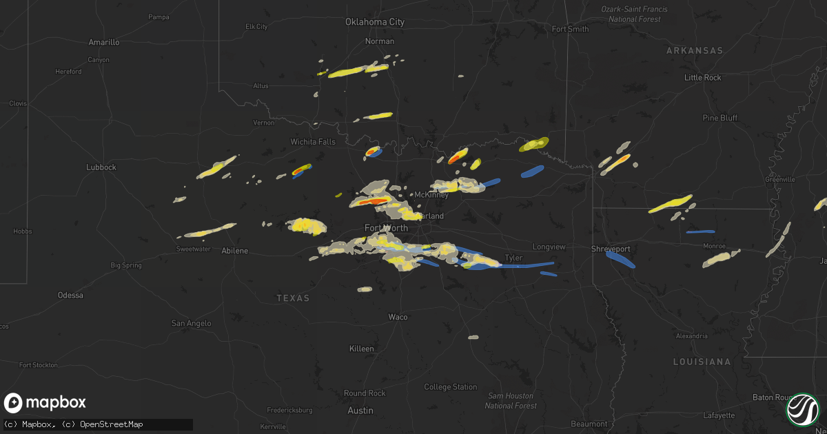
Hail Map on April 4, 2022
Get this storm
April 4 map
$229
one time, instant access
Download today. No call, no setup
Keep the $229
Bought the map and want the full workflow? Apply the entire $229 to a subscription within 7 days. None of it is wasted.
Every map, not just this one
This buys you this map. Subscription and you get every map we run, in the markets you choose from a few cities to whole states to nationwide. Plus real-time alerts the moment a storm fires.
Contact data
Name, contact info, occupancy, even credit band for addresses in the footprint. You go from where it hit to who to call.
Become the source they trust
Unlimited branding weather history reports on demand. You already have the documented answer ready for the property owner, and you are the one who showed up with it.
Property data and RoofTrace estimates
Pull up any address you have got, its value and the exact code rules for that jurisdiction, straight from One Click Code. Then RoofTrace estimates the squares, pitch, and roof value, priced the way you price.
Storm reports
Alabama
| Date | Description |
|---|---|
| 04/04/20226:00 AM CDT | Pictures on social media of hail of quarter to ping pong ball size. |
| 04/04/20225:49 AM CDT | Estimated ping pong-ball sized hail south of thomaston. Time estimated by radar. |
| 04/04/20225:22 AM CDT | Large hail reported just east of the county line. |
| 04/04/20225:17 AM CDT | A local report indicates 1.50 inch wind near LAVACA |
| 04/04/20224:40 AM CDT | Picture on social media of egg-sized hail near linden. Time estimated by radar. |
| 04/04/20224:40 AM CDT | Pictures on social media of large hail ranging from egg-sized to baseball size around linden. Several vehicles had their windows broken out. |
Oregon
| Date | Description |
|---|---|
| 04/03/202210:26 PM CDT | At 325 PM PDT, a severe thunderstorm was located 9 miles east of Manzanita, moving east at 40 mph. HAZARD...60 mph wind gusts. SOURCE...Radar indicated. IMPACT...Expect damage to roofs, siding, and trees. Locations impacted include... Hamlet, Salmonberry and Sunset Summit. |
Washington
| Date | Description |
|---|---|
| 04/04/20224:39 PM CDT | Report from mping: 1-inch tree limbs broken; shingles blown off. |
| 04/04/20224:27 PM CDT | Report from mping: 1-inch tree limbs broken; shingles blown off. |
| 04/04/20223:00 PM CDT | Report from mping: 1-inch tree limbs broken; shingles blown off. |
| 04/04/20222:50 PM CDT | Trees down on us-395 at mp226. |
| 04/04/202212:43 PM CDT | Report from mping: 1-inch tree limbs broken; shingles blown off. |
Wyoming
| Date | Description |
|---|---|
| 04/04/20223:16 AM CDT | Bordeaux wydot site. Sustained winds 41 mph. |
Arkansas
| Date | Description |
|---|---|
| 04/04/20226:36 AM CDT | At 1136 PM CDT, a severe thunderstorm was located over Fulton, or 13 miles west of Hope, moving northeast at 55 mph. HAZARD...60 mph wind gusts and quarter size hail. SOURCE...Radar indicated. IMPACT...Hail damage to vehicles is expected. Expect wind damage to roofs, siding, and trees. Locations impacted include... Hope, Prescott, Emmet, Blevins, Perrytown, Fulton, Washington, McCaskill, McNab, Oakhaven and Boughton. |
| 04/04/20224:14 AM CDT | Tree down on a home on 8th ave. |
| 04/04/20223:20 AM CDT | Tree down on wesson road... Time est by radar. |
| 04/04/202212:45 AM CDT | Reported in the faircrest community. |
| 04/04/202212:34 AM CDT | Reported in the wesson community. |
| 04/04/202212:03 AM CDT | Hail from ranging from half dollar to golf ball size reported in the city of hope. |
| 04/03/202211:43 PM CDT | Reported in the cross roads community. |
Oklahoma
| Date | Description |
|---|---|
| 04/04/20221:25 PM CDT | On hwy 77. |
| 04/04/202212:15 PM CDT | A local report indicates 1.00 inch wind near 5 N LONE GROVE |
| 04/04/202212:00 PM CDT | A local report indicates 1.00 inch wind near 3 SSW LAKE ELLSWORTH |
| 04/04/20227:54 AM CDT | At 1254 PM CDT, a severe thunderstorm was located near Bradley, moving east at 40 mph. HAZARD...Quarter size hail. SOURCE...Radar indicated. IMPACT...Damage to vehicles is expected. Locations impacted include... Southern Norman, Purcell, Noble, Slaughterville, Lindsay, Lexington, Maysville, Wayne, Washington, Alex, Bradley, Criner, Payne and Erin Springs. |
| 04/04/20227:19 AM CDT | At 1218 PM CDT, a severe thunderstorm was located 5 miles northeast of Sterling, moving northeast at 40 mph. HAZARD...Quarter size hail. SOURCE...Radar indicated. IMPACT...Damage to vehicles is expected. Locations impacted include... Rush Springs, Dibble, Sterling, Cole, Alex, Bradley, Agawam, Criner, Ninnekah, Acme and Payne. |
| 04/04/20226:40 AM CDT | At 1139 AM CDT, a severe thunderstorm was located near Healdton, moving east at 30 mph. HAZARD...Quarter size hail. SOURCE...Radar indicated. IMPACT...Damage to vehicles is expected. Locations impacted include... Ardmore, Lone Grove, Healdton, Wilson, Dickson, Ringling, Springer, Gene Autry and Milo. |
| 04/04/20226:00 AM CDT | At 1100 PM CDT, a severe thunderstorm was located near Blossom, or 13 miles east of Paris, moving east at 40 mph. HAZARD...60 mph wind gusts and quarter size hail. SOURCE...Radar indicated. IMPACT...Hail damage to vehicles is expected. Expect wind damage to roofs, siding, and trees. Locations impacted include... Clarksville, Bagwell, Detroit, Annona, Negley, Bryarly and English. |
| 04/04/20224:44 AM CDT | At 943 PM CDT, a severe thunderstorm was located near Honey Grove, or 14 miles west of Paris, moving northeast at 30 mph. HAZARD...60 mph wind gusts and quarter size hail. SOURCE...Radar indicated. IMPACT...Hail damage to vehicles is expected. Expect wind damage to roofs, siding, and trees. Locations impacted include... Paris, Honey Grove, Blossom, Roxton, Toco and Sun Valley. |
| 04/04/20222:57 AM CDT | At 757 PM CDT, a severe thunderstorm was located 8 miles south of Muenster, or 13 miles southwest of Gainesville, moving east at 30 mph. HAZARD...60 mph wind gusts and quarter size hail. SOURCE...Radar indicated. IMPACT...Hail damage to vehicles is expected. Expect wind damage to roofs, siding, and trees. Locations impacted include... Gainesville, Muenster, Lindsay, Callisburg, Lake Kiowa and Valley View.This includes Interstate 35 between mile markers 483 and 503. |
| 04/04/20222:44 AM CDT | At 744 PM CDT, a severe thunderstorm was located over Ravenna, or near Bonham, moving northeast at 25 mph. HAZARD...60 mph wind gusts and quarter size hail. SOURCE...Radar indicated. IMPACT...Hail damage to vehicles is expected. Expect wind damage to roofs, siding, and trees. Locations impacted include... Bonham and Ravenna. |
| 04/04/20222:42 AM CDT | At 741 PM CDT, a severe thunderstorm was located over Leon, or 17 miles east of Nocona, moving northeast at 30 mph. HAZARD...65 mph wind gusts and half dollar size hail. SOURCE...Radar indicated. IMPACT...Hail damage to vehicles is expected. Expect wind damage to roofs, siding, and trees. This severe thunderstorm will remain over mainly rural areas of east central Montague and northwestern Cooke Counties. |
| 04/04/20222:27 AM CDT | At 727 PM CDT, a severe thunderstorm was located near Kemp, moving northeast at 20 mph. HAZARD...60 mph wind gusts and quarter size hail. SOURCE...Radar indicated. IMPACT...Hail damage to vehicles is expected. Expect wind damage to roofs, siding, and trees. Locations impacted include... Achille, Kemp, Hendrix, Blue, Utica, Albany and Wade. |
| 04/04/20222:17 AM CDT | At 717 PM CDT, a severe thunderstorm was located 4 miles northwest of St. Jo, moving northeast at 20 mph. HAZARD...Ping pong ball size hail and 60 mph wind gusts. SOURCE...Radar indicated. IMPACT...People and animals outdoors will be injured. Expect hail damage to roofs, siding, windows, and vehicles. Expect wind damage to roofs, siding, and trees. Locations impacted include... Leon, Rubottom and Burneyville. |
| 04/04/20222:03 AM CDT | At 703 PM CDT, a severe thunderstorm was located near St. Jo, or 8 miles southeast of Nocona, moving northeast at 30 mph. HAZARD...60 mph wind gusts and quarter size hail. SOURCE...Radar indicated. IMPACT...Hail damage to vehicles is expected. Expect wind damage to roofs, siding, and trees. Locations impacted include... St. Jo. |
| 04/04/202212:23 AM CDT | So reports large limbs down. |
| 04/03/202210:43 PM CDT | A local report indicates 1.00 inch wind near IDABEL |
| 04/03/202210:33 PM CDT | A local report indicates 1.00 inch wind near GARVIN |
| 04/03/20228:27 PM CDT | At 127 PM CDT, a severe thunderstorm was located near Wayne, moving east at 40 mph. HAZARD...Ping pong ball size hail. SOURCE...Radar indicated. IMPACT...People and animals outdoors will be injured. Expect damage to roofs, siding, windows, and vehicles. Locations impacted include... Wayne, Paoli, Asher, Wanette, Byars, St. Louis and Rosedale. |
Texas
| Date | Description |
|---|---|
| 04/04/20226:55 PM CDT | A local report indicates 1.25 inch wind near 4 WNW LAKE VIEW |
| 04/04/20226:55 PM CDT | A local report indicates 1.00 inch wind near LAKE VIEW |
| 04/04/20226:45 PM CDT | A local report indicates 1.50 inch wind near LAKE VIEW |
| 04/04/20226:35 PM CDT | Quarter size hail |
| 04/04/20226:41 AM CDT | At 1141 PM CDT, severe thunderstorms were located along a line extending from 10 miles northeast of Clarksville to near Wilkerson to near Purley, moving east at 35 mph. HAZARD...60 mph wind gusts and quarter size hail. SOURCE...Radar indicated. IMPACT...Hail damage to vehicles is expected. Expect wind damage to roofs, siding, and trees. Locations impacted include... Mount Pleasant, Clarksville, Boxelder, Mount Vernon, De Kalb, Naples, Omaha, Us 259 And I 30 Intersection, Cookville, Wilkerson, Purley, Dalby Springs, Cason, Winfield, Talco, Avery, Annona, Haworth, Miller's Cove and Moon. |
| 04/04/20226:28 AM CDT | At 1128 PM CDT, severe thunderstorms were located along a line extending from near Oak Leaf to near Grandview, moving east at 40 mph. HAZARD...65 mph wind gusts and quarter size hail. SOURCE...Radar indicated. IMPACT...Hail damage to vehicles is expected. Expect wind damage to roofs, siding, and trees. Locations impacted include... Grand Prairie, Mansfield, Cedar Hill, Lancaster, Waxahachie, Ennis, Midlothian, Glenn Heights, Red Oak, Ovilla, Venus, Ferris, Palmer, Italy, Grandview, Oak Leaf, Maypearl, Bardwell, Alma and Garrett.This includes the following highways... Interstate 35W between mile markers 11 and 19. Interstate 35E between mile markers 383 and 411. Interstate 45 between mile markers 244 and 266. |
| 04/04/20226:07 AM CDT | At 1106 PM CDT, severe thunderstorms were located along a line extending from 9 miles southwest of Deport to 6 miles northeast of Sulphur Springs, moving east at 45 mph. HAZARD...60 mph wind gusts and quarter size hail. SOURCE...Radar indicated. IMPACT...Hail damage to vehicles is expected. Expect wind damage to roofs, siding, and trees. Locations impacted include... Mount Pleasant, Hagansport, Boxelder, Mount Vernon, Bogata, Wilkerson, Winfield, Talco, Miller's Cove, Harts Bluff, Johntown and Cuthand. |
| 04/04/20225:49 AM CDT | At 1048 PM CDT, a severe thunderstorm was located over Burleson, moving east at 35 mph. HAZARD...65 mph wind gusts and quarter size hail. SOURCE...Radar indicated. IMPACT...Hail damage to vehicles is expected. Expect wind damage to roofs, siding, and trees. Locations impacted include... Dallas, Fort Worth, Arlington, Grand Prairie, Mansfield, Desoto, Cedar Hill, Duncanville, Burleson, Lancaster, Waxahachie, Cleburne, Benbrook, Midlothian, Crowley, Forest Hill, Glenn Heights, Red Oak, Kennedale and Everman. |
| 04/04/20225:40 AM CDT | At 1039 PM CDT, a severe thunderstorm was located over University Park, moving southeast at 20 mph. HAZARD...Quarter size hail. SOURCE...Radar indicated. IMPACT...Damage to vehicles is possible. Locations impacted include... Dallas, Garland, Irving, Mesquite, Carrollton, Richardson, Rowlett, Wylie, Rockwall, Farmers Branch, Balch Springs, University Park, Sachse, Addison, Highland Park, Hutchins, Heath, Fate, Sunnyvale and Wilmer. |
| 04/04/20225:25 AM CDT | At 1024 PM CDT, a severe thunderstorm was located 9 miles west of Idabel, or 19 miles north of Clarksville, moving northeast at 30 mph. HAZARD...60 mph wind gusts and quarter size hail. SOURCE...Radar indicated. IMPACT...Hail damage to vehicles is expected. Expect wind damage to roofs, siding, and trees. Locations impacted include... Idabel, Broken Bow, Garvin, Farmers Hill, Holly Creek, Glover, Albion, Oak Hill, Golden and Silver City. |
| 04/04/20225:16 AM CDT | At 1015 PM CDT, a severe thunderstorm was located near Annetta, or 11 miles southeast of Weatherford, moving east at 30 mph. HAZARD...60 mph wind gusts and quarter size hail. SOURCE...Radar indicated. IMPACT...Hail damage to vehicles is expected. Expect wind damage to roofs, siding, and trees. Locations impacted include... Fort Worth, Burleson, Benbrook, White Settlement, Crowley, River Oaks, Everman, Joshua, Edgecliff Village, Aledo, Westworth Village, Annetta, Cross Timber, Edgecliff, Westover Hills, Annetta South, Annetta North and Briaroaks.This includes the following highways... Interstate 35W between mile markers 34 and 53. Interstate 20 between mile markers 420 and 438. Interstate 30 between mile markers 1 and 16. |
| 04/04/20225:06 AM CDT | At 1005 PM CDT, a severe thunderstorm was located over Wolfe City, or 10 miles northwest of Commerce, moving east at 40 mph. HAZARD...65 mph wind gusts and half dollar size hail. SOURCE...Radar indicated. IMPACT...Hail damage to vehicles is expected. Expect wind damage to roofs, siding, and trees. Locations impacted include... Greenville, Sulphur Springs, Commerce, Cooper, Wolfe City, Cumby, Campbell, Deport, Cooper Lake Park South Sulphur, Cooper Lake Park Doctors Creek, Roxton, Ladonia, Tira, Pecan Gap and Neylandville.This includes Interstate 30 between mile markers 111 and 142. |
| 04/04/20224:45 AM CDT | At 945 PM CDT, severe thunderstorms were located along a line extending from Grapevine to Fort Worth, moving east at 25 mph. HAZARD...60 mph wind gusts and quarter size hail. SOURCE...Radar indicated. IMPACT...Hail damage to vehicles is expected. Expect wind damage to roofs, siding, and trees. Locations impacted include... Dallas, Fort Worth, Arlington, Garland, Irving, Grand Prairie, Carrollton, Richardson, Flower Mound, Rowlett, Euless, Bedford, Grapevine, Haltom City, Wylie, Keller, Coppell, Hurst, Farmers Branch and Southlake.This includes the following highways... Interstate 35W between mile markers 55 and 56. Interstate 35E between mile markers 424 and 445. Interstate 30 between mile markers 31 and 51. Interstate 45 between mile markers 282 and 284. |
| 04/04/20224:24 AM CDT | At 924 PM CDT, a severe thunderstorm was located over Anna, or 9 miles northeast of McKinney, moving east at 30 mph. HAZARD...60 mph wind gusts and nickel size hail. SOURCE...Radar indicated. IMPACT...Expect damage to roofs, siding, and trees. Locations impacted include... McKinney, Greenville, Anna, Princeton, Farmersville, Van Alstyne, Howe, Leonard, Whitewright, Wolfe City, Celeste, Bailey, Melissa, Blue Ridge, Trenton, New Hope, Weston and Westminster. |
| 04/04/20224:16 AM CDT | At 915 PM CDT, a severe thunderstorm was located over Bartonville, or near Trophy Club, moving east at 25 mph. HAZARD...60 mph wind gusts and half dollar size hail. SOURCE...Radar indicated. IMPACT...Hail damage to vehicles is expected. Expect wind damage to roofs, siding, and trees. Locations impacted include... Plano, McKinney, Carrollton, Frisco, Denton, Richardson, Lewisville, Allen, Flower Mound, Coppell, The Colony, Southlake, Corinth, Highland Village, Trophy Club, Lake Dallas, Lake Lewisville, Little Elm, Murphy and Prosper.This includes the following highways... Interstate 35W between mile markers 68 and 77. Interstate 35E between mile markers 446 and 465. |
| 04/04/20224:01 AM CDT | At 901 PM CDT, a severe thunderstorm was located 8 miles southwest of Possum Kingdom State Park, or 16 miles east of Breckenridge, moving east at 40 mph. HAZARD...60 mph wind gusts and half dollar size hail. SOURCE...Radar indicated. IMPACT...Hail damage to vehicles is expected. Expect wind damage to roofs, siding, and trees. Locations impacted include... Mineral Wells, Graford and Possum Kingdom State Park. This includes Interstate 20 between mile markers 378 and 389. |
| 04/04/20223:09 AM CDT | At 808 PM CDT, a severe thunderstorm was located 9 miles east of Albany, moving northeast at 30 mph. HAZARD...Ping pong ball size hail and 60 mph wind gusts. SOURCE...Radar indicated. IMPACT...People and animals outdoors will be injured. Expect hail damage to roofs, siding, windows, and vehicles. Expect wind damage to roofs, siding, and trees. Locations impacted include... Wade. |
| 04/04/20222:52 AM CDT | At 752 PM CDT, severe thunderstorms were located along a line extending from 11 miles west of Sanger to near Springtown, moving east at 30 mph. HAZARD...60 mph wind gusts and quarter size hail. SOURCE...Radar indicated. IMPACT...Hail damage to vehicles is expected. Expect wind damage to roofs, siding, and trees. Locations impacted include... Frisco, Denton, Lewisville, Flower Mound, Grapevine, The Colony, Southlake, Corinth, Highland Village, Trophy Club, Lake Dallas, Sanger, Decatur, northwestern Lake Lewisville, Briar, Little Elm, Roanoke, Pecan Acres, Krum and Pilot Point.This includes the following highways... Interstate 35 between mile markers 468 and 481. Interstate 35W between mile markers 68 and 85. Interstate 35E between mile markers 453 and 466. |
| 04/04/20222:47 AM CDT | Report from mping: 1-inch tree limbs broken; shingles blown off. |
| 04/04/20222:15 AM CDT | Small trees and debris across fm 225 south of henderson. |
| 04/04/20222:10 AM CDT | Roof/awning damage on richardson drive in henderson. |
| 04/04/20222:10 AM CDT | Roof blown off a building in downtown henderson. |
| 04/04/20222:06 AM CDT | Large tree down and small limb debris on cr 407 near lakeview rv park. |
| 04/04/20222:05 AM CDT | Storage building blown to the side of the roadway on sh 64 near sh 42 in turnertown. |
| 04/04/20222:05 AM CDT | Large tree down on us hwy 259 between henderson and kilgore. |
| 04/04/20222:00 AM CDT | At 700 PM CDT, a severe thunderstorm was located near Chico, or 9 miles northwest of Bridgeport, moving east at 35 mph. HAZARD...60 mph wind gusts. SOURCE...Radar indicated. IMPACT...Expect damage to roofs, siding, and trees. Locations impacted include... Decatur, Bridgeport, Briar, Pecan Acres, Alvord, New Fairview, Aurora, Boyd, Chico, Paradise, Cottondale, Boonsville, Rhome, Runaway Bay, Newark and Lake Bridgeport. |
| 04/04/20222:00 AM CDT | Powerlines downed in and around the new london community. |
| 04/04/20221:50 AM CDT | Corrects previous report for location... Tree down on cr 449 at fm 450. |
| 04/04/20221:44 AM CDT | Tree down on cr 449. |
| 04/04/20221:42 AM CDT | Multiple reports of trees down in whitehouse. Trees on at least 4 homes in town. Another tree down on 110 and main street along with powerlines downed. |
| 04/04/20221:41 AM CDT | Tree reported down on cr 3304. |
| 04/04/20221:39 AM CDT | At 639 PM CDT, a severe thunderstorm was located near Amistad Village, or 11 miles west of Del Rio, moving northeast at 35 mph. HAZARD...60 mph wind gusts and half dollar size hail. SOURCE...Radar indicated. IMPACT...Hail damage to vehicles is expected. Expect wind damage to roofs, siding, and trees. Locations impacted include... Del Rio, Lake View, Amistad Village, Black Brush Point, Diablo East, Governors Landing, Long Point, Cienegas Terrace, Amistad Acres, Devils Shores, Pafford Crossing, 277 South Boat Ramp, 277 North Campground, San Pedro Canyon, Rough Canyon Recreation Area, Spur 406 Campground, Rock Quarry Campground, Salem Point, Devils River State Nat Area Big Satan and Lake Ridge Ranch. |
| 04/04/20221:38 AM CDT | Trees and utility lines down across the county... Delaying school. |
| 04/04/20221:36 AM CDT | Barn blown down and multiple trees blocking vzcr 2416 approximately 3/4 mile west of highway 198. Power outages reported. |
| 04/04/20221:23 AM CDT | Tree reported down on cr 3782. Time estimated by radar. |
| 04/04/202212:55 AM CDT | Trees down blocking highway 1861 approximately 1 mile east of hwy 19. |
| 04/04/202212:50 AM CDT | Homeowner reported roof blown off home. |
| 04/04/202212:35 AM CDT | Trees down across power lines. |
| 04/04/202212:28 AM CDT | Significant building damage and metal debris up and down highway 175. |
| 04/04/202212:23 AM CDT | At 521 PM CDT, a severe thunderstorm was located near Neinda, moving east at 40 mph. HAZARD...60 mph wind gusts and quarter size hail. SOURCE...Radar indicated. IMPACT...Hail damage to vehicles is expected. Expect wind damage to roofs, siding, and trees. This severe thunderstorm will be near... Neinda around 525 PM CDT. Anson around 540 PM CDT.Other locations impacted by this severe thunderstorm include Trubyand The Intersection Of Us-180 And Ranch Road 126. |
| 04/04/202212:21 AM CDT | Corrects previous tstm wnd dmg report from 1 se omaha. Tree reported down on cr 3304. |
| 04/04/202212:16 AM CDT | Delayed report: tree damage consistent with straight line winds was found in far northeast navarro county along fm 85 going toward henderson county. Time estimated. |
| 04/04/202212:04 AM CDT | Mesonet station text2 texarkana. |
| 04/03/202211:41 PM CDT | At 441 PM CDT, a severe thunderstorm was located 5 miles southeast of Archer City, moving northeast at 25 mph. HAZARD...60 mph wind gusts and quarter size hail. SOURCE...Radar indicated. IMPACT...Hail damage to vehicles is expected. Expect wind damage to roofs, siding, and trees. Locations impacted include... Henrietta, Archer City, Scotland, Windthorst, Jolly, Lake Arrowhead and Bluegrove. |
| 04/03/202211:30 PM CDT | Corrects previous tstm wnd dmg report from 4 ssw ovilla. Delayed report: 12 inch tree knocked over near hackberry ct in midlothian. Time corrected. |
| 04/03/202211:17 PM CDT | 18-wheeler flipped over at love's in midlothian |
| 04/03/202211:05 PM CDT | Cr510 and adriels lane |
| 04/03/202211:00 PM CDT | Homes damaged 2 miles south of lillian |
| 04/03/202210:55 PM CDT | Metal roof partially torn off of building in deport. Time estimated from radar. |
| 04/03/202210:52 PM CDT | At 352 PM CDT, a severe thunderstorm was located 8 miles north of Olney, moving northeast at 45 mph. HAZARD...60 mph wind gusts and quarter size hail. SOURCE...Radar indicated. IMPACT...Hail damage to vehicles is expected. Expect wind damage to roofs, siding, and trees. Locations impacted include... Henrietta, Archer City, Scotland, Windthorst, Lake Arrowhead, Bluegrove and Joy. |
| 04/03/202210:50 PM CDT | Quarter hail 2 miles southwest of spinks airport. |
| 04/03/202210:48 PM CDT | Quarter hail at walnut hill lane and hillcrest rd. |
| 04/03/202210:45 PM CDT | Quarter hail at fm1902 and cr920. |
| 04/03/202210:45 PM CDT | Multiple power poles and large trees down at main st. |
| 04/03/202210:34 PM CDT | At 334 PM CDT, a severe thunderstorm was located 7 miles south of Jayton, moving east at 45 mph. HAZARD...60 mph wind gusts and quarter size hail. SOURCE...Radar indicated. IMPACT...Hail damage to vehicles is expected. Expect wind damage to roofs, siding, and trees. Locations impacted include... Aspermont, Jayton, Peacock, Swenson and Us-380 Near The Haskell- Stonewall County Line. |
| 04/03/202210:30 PM CDT | Delayed report: 12 inch tree knocked over near hackberry ct in midlothian. |
| 04/03/202210:26 PM CDT | At 326 PM CDT, a severe thunderstorm was located near Rhineland, moving northeast at 40 mph. HAZARD...60 mph wind gusts and quarter size hail. SOURCE...Radar indicated. IMPACT...Hail damage to vehicles is expected. Expect wind damage to roofs, siding, and trees. Locations impacted include... Vera, Rhineland and Lake Kemp. |
| 04/03/202210:25 PM CDT | At 324 PM CDT, a severe thunderstorm was located near Gilliland, moving northeast at 40 mph. HAZARD...60 mph wind gusts and quarter size hail. SOURCE...Radar indicated. IMPACT...Hail damage to vehicles is expected. Expect wind damage to roofs, siding, and trees. Locations impacted include... Gilliland and Lockett. |
| 04/03/202210:05 PM CDT | Quarter hail in coppell. |
| 04/03/20229:58 PM CDT | Half dollar hail 1 mile west of kingston. |
| 04/03/20229:47 PM CDT | At 247 PM CDT, a severe thunderstorm was located 15 miles southeast of Guthrie, moving northeast at 40 mph. HAZARD...Quarter size hail. SOURCE...Radar indicated. IMPACT...Damage to vehicles is expected. Locations impacted include... Benjamin, Gilliland and Truscott. |
| 04/03/20229:36 PM CDT | At 235 PM CDT, a severe thunderstorm was located 12 miles southeast of Guthrie, moving northeast at 40 mph. HAZARD...60 mph wind gusts and half dollar size hail. SOURCE...Radar indicated. IMPACT...Hail damage to vehicles is expected. Expect wind damage to roofs, siding, and trees. This severe thunderstorm will remain over mainly rural areas of eastern King and northern Stonewall Counties. |
| 04/03/20229:35 PM CDT | Home lost roof... Partial collapse of structure |
| 04/03/20228:38 PM CDT | Half dollar hail 1 mile north of propwash airport. |
| 04/03/20228:30 PM CDT | Half dollar hail in new fairview. |
| 04/03/20228:26 PM CDT | Quarter hail 6 miles north of rhome. |
| 04/03/20228:12 PM CDT | Quarter hail 1 mile north of boyd. |
| 04/03/20227:50 PM CDT | Golf ball hail 2 miles northeast of ravenna. |
| 04/03/20227:35 PM CDT | Quarter hail 5 miles north of saint jo. |
| 04/03/20227:24 PM CDT | Half dollar hail in bonita. |
Louisiana
| Date | Description |
|---|---|
| 04/04/20225:40 AM CDT | Tree and power line down. |
| 04/04/20224:55 AM CDT | Tree down on mengel road. |
| 04/04/20224:25 AM CDT | Scattered trees down across the parish. |
| 04/04/20224:18 AM CDT | Tree down along swartz fairbanks road. Time estimated by radar. |
| 04/04/20224:15 AM CDT | Report of a tree down along cheniere-drew road in west monroe. Time estimated by radar. |
| 04/04/20223:50 AM CDT | Trees down on hwy 33 just north of the lincoln/union parish line. Powerlines also down at the same location. |
| 04/04/20223:42 AM CDT | About 20 trees down blocking la146. |
| 04/04/20223:36 AM CDT | Multiple trees down included large oak tree on ruggs bluff road near downsville. |
| 04/04/20223:34 AM CDT | Roads closed across the parish due to fallen trees and tree debris: hwy 33 n @ up elementary school |
| 04/04/20223:30 AM CDT | La 146 1/2 mile west of la 545... About 20 trees down blocking la 146. |
| 04/04/20223:28 AM CDT | Tree reported down along highway 371 on the east side of hall summit south of highway 514. |
| 04/04/20223:25 AM CDT | Tree blown down on a house on amy gee lane. Other reports of trees down throughout the northern half of the parish. Time estimated by radar. |
| 04/04/20223:05 AM CDT | *** 1 fatal *** a tree was downed northeast of minden across hwy 79 just north of grider road. Approximately 345 am... A motorist was killed when his vehicle he was dri |
| 04/04/20222:56 AM CDT | Awos station kbad barksdale afb. |
| 04/04/20222:50 AM CDT | Tree down near dixie meadow road and dixie garden road. |
| 04/04/20222:50 AM CDT | Powerlines down near east stoner and viking drive and river parkway drive. |
| 04/04/20222:50 AM CDT | Large tree fell on robinson place. |
| 04/04/20222:49 AM CDT | Multiple homes with shingles blown off mackey lane and hoyt streets. |
| 04/04/20222:45 AM CDT | Tree down at greenwood baptist church road and greenwood springridge road. |
| 04/04/20221:50 AM CDT | A local report indicates 1.00 inch wind near 4 SSW GIRARD |
Mississippi
| Date | Description |
|---|---|
| 04/04/20226:51 AM CDT | Trees and power lines down along hwy 481 just north of the smith county line. Tds also noted on radar. |
| 04/04/20226:45 AM CDT | 2 large oak trees down on hwy 28 near pinola. |
| 04/04/20226:35 AM CDT | Corrects previous tstm wnd dmg report from 1 wsw bude. Tree down across hwy 98. |
| 04/04/20226:35 AM CDT | Numerous trees down... With some down on power lines... In the city of brookhaven. |
| 04/04/20226:25 AM CDT | Picture of a fence blown down at a home in byram. |
| 04/04/20226:23 AM CDT | Tree down on power lines on gary rd near red oak cove. |
| 04/04/20226:15 AM CDT | Trees and power lines down in the union church area. |
| 04/04/20226:14 AM CDT | Tree down with power lines blocking one lane of traffic on springridge rd near big creek rd. |
| 04/04/20226:13 AM CDT | Tree down in clinton. |
| 04/04/20226:10 AM CDT | A few trees down. |
| 04/04/20225:55 AM CDT | Trees down in the church hill area. |
| 04/04/20225:53 AM CDT | Trees reported down in the edwards area. |
| 04/04/20225:50 AM CDT | Scattered trees down. |
| 04/04/20225:45 AM CDT | Scattered trees down in the county. |
| 04/04/20225:36 AM CDT | Tree down along hwy 61 in redwood. |
| 04/04/20225:14 AM CDT | Social media report of nickel to quarter size hail near crystal springs. Time and location estimated with radar. |
| 04/04/20225:01 AM CDT | At 1000 PM CDT, a severe thunderstorm was located near Slidell, moving northeast at 30 mph. HAZARD...60 mph wind gusts and quarter size hail. SOURCE...Radar indicated. IMPACT...Hail damage to vehicles is expected. Expect wind damage to roofs, siding, and trees. Locations impacted include... Slidell and Pearlington. This includes Interstate 10 in Louisiana between mile markers 261 and273. |
| 04/04/20224:51 AM CDT | Dime to quarter size hail covering the parking lot of a gas station in stewart. |
| 04/04/20223:34 AM CDT | Hail to the size of quarters reported in lena. |
| 04/04/20223:30 AM CDT | Ping pong ball sized hail. |
| 04/04/20223:09 AM CDT | Hail to the size of golf balls fell along stump ridge road. |
| 04/04/20223:05 AM CDT | Hail measured at 2.1 inches fell along holly bush road near the mcclain lodge area. Report with picture relayed via twitter. |
| 04/04/20223:05 AM CDT | Hail to the size of golf balls fell in the bay pointe neighborhood. Report with picture relayed via twitter. |
| 04/04/20222:59 AM CDT | At least golf ball hail reported along hugh ward blvd. |
| 04/04/20222:59 AM CDT | Hail measured at 1.50 inches fell near the intersection of hwy 471 and spillway rd. Report with picture relayed via twitter. |
Florida
| Date | Description |
|---|---|
| 04/04/20226:46 PM CDT | << late report >> time estimated by radar. Web cam caught a skinny rope tornado. Reports of power lines down in area. |
| 04/04/20225:53 PM CDT | Multiple golf ball size hail reports near avon park... Fl from trained spotters. |
| 04/04/20225:35 PM CDT | Multiple golf ball size hail reports near sebring... Fl from nws employee and trained spotters. |
| 04/04/20223:00 PM CDT | Emergency managers reported hail up to the size of quarters. Car reported dented from large hail along hwy 80 at the border of glades and hendry counties. |
| 04/04/20222:44 PM CDT | La belle fire station employee reported quarter size hail. |
| 04/04/20222:40 PM CDT | Emergency manager reported quarter to one-half dollar sized hail in the town of labelle. Time radar estimated. |
| 04/04/20222:40 PM CDT | Delayed report: broadcast media wink news fort myers... Relayed a report and photo of hail associated with a severe thunderstorm in labelle. The hail was estimated to b |
| 04/04/20222:43 AM CDT | At 742 PM EDT, a severe thunderstorm was located near Wauchula, moving northeast at 20 mph. HAZARD...60 mph wind gusts and quarter size hail. SOURCE...Radar indicated. IMPACT...Hail damage to vehicles is expected. Expect wind damage to roofs, siding, and trees. Locations impacted include... Avon Park and Avon Park Executive Airport. |
| 04/04/20222:34 AM CDT | At 733 PM EDT, a severe thunderstorm was located 10 miles southwest of Lake Marian, moving northeast at 25 mph. HAZARD...Ping pong ball size hail and 60 mph wind gusts. SOURCE...Radar indicated. IMPACT...People and animals outdoors will be injured. Expect hail damage to roofs, siding, windows, and vehicles. Expect wind damage to roofs, siding, and trees. Locations impacted include... Lake Kissimmee, Lake Marian, Kenansville and Forever Florida. |
| 04/04/20222:17 AM CDT | At 716 PM EDT, a severe thunderstorm was located 13 miles northeast of Avon Park, moving northeast at 30 mph. HAZARD...Golf ball size hail and 60 mph wind gusts. SOURCE...Trained weather spotters. IMPACT...People and animals outdoors will be injured. Expect hail damage to roofs, siding, windows, and vehicles. Expect wind damage to roofs, siding, and trees. Locations impacted include... River Ranch and Indian Lake Estates. |
| 04/04/20221:44 AM CDT | At 644 PM EDT, a severe thunderstorm was located near Sebring, moving northeast at 25 mph. HAZARD...60 mph wind gusts and half dollar size hail. SOURCE...Radar indicated. IMPACT...Hail damage to vehicles is expected. Expect wind damage to roofs, siding, and trees. Locations impacted include... Sebring, Avon Park, Avon Park Air Force Range, Sebring Shores and Avon Park Executive Airport. |
| 04/04/20221:21 AM CDT | At 620 PM EDT, a severe thunderstorm was located 9 miles west of Sebring, moving northeast at 25 mph. HAZARD...60 mph wind gusts and half dollar size hail. SOURCE...Radar indicated. IMPACT...Hail damage to vehicles is expected. Expect wind damage to roofs, siding, and trees. Locations impacted include... Sebring, Avon Park, Crewsville, Sebring Shores and Avon Park Executive Airport. |
| 04/04/202212:51 AM CDT | At 551 PM EDT, a severe thunderstorm was located near Big Cypress Seminole Reservation, or 27 miles east of Ave Maria, moving southeast at 10 mph. HAZARD...60 mph wind gusts and half dollar size hail. SOURCE...Radar indicated. IMPACT...Hail damage to vehicles is expected. Expect wind damage to roofs, siding, and trees. Locations impacted include... Hendry Correctional, Miccosukee Indian Reservation, Big Cypress Seminole Reservation, Miccosukee Service Plaza and Big Cypress National Preserve. |
| 04/04/202212:16 AM CDT | At 516 PM EDT, severe thunderstorms were located along a line extending from 8 miles west of Felda to 6 miles east of Immokalee to near Big Cypress Seminole Reservation, moving south at 15 mph. HAZARD...60 mph wind gusts and half dollar size hail. SOURCE...Radar indicated. IMPACT...Hail damage to vehicles is expected. Expect wind damage to roofs, siding, and trees. Locations impacted include... Ave Maria, Immokalee, Felda, Miccosukee Service Plaza and Hendry Correctional. |
| 04/03/202211:41 PM CDT | At 441 PM EDT, severe thunderstorms were located along a line extending from 7 miles northwest of Big Cypress Seminole Reservation to near Immokalee to Southwest Florida Airport, moving south at 5 mph. HAZARD...60 mph wind gusts and quarter size hail. SOURCE...Radar indicated. IMPACT...Hail damage to vehicles is possible. Wind damage to roofs, siding, and trees may also occur. Locations impacted include... Ave Maria, Immokalee, Hendry Correctional, Felda and Big Cypress Seminole Reservation. |
| 04/03/202211:24 PM CDT | At 423 PM EDT, a severe thunderstorm was located near Pa-Hay-Okee Overlook, or 18 miles northeast of Flamingo, moving southeast at 10 mph. HAZARD...60 mph wind gusts and quarter size hail. SOURCE...Radar indicated. IMPACT...Hail damage to vehicles is expected. Expect wind damage to roofs, siding, and trees. Locations impacted include... Mahogany Hammock, Pa-Hay- Okee Overlook, Royal Palm Ranger and Everglades National Park. |
| 04/03/202211:15 PM CDT | At 415 PM EDT, a severe thunderstorm was located near Copeland, or 12 miles north of Everglades City, moving southeast at 20 mph. HAZARD...60 mph wind gusts and half dollar size hail. SOURCE...Radar indicated. IMPACT...Hail damage to vehicles is possible. Wind damage to roofs, siding, and trees may also occur. Locations impacted include... Carnestown, Big Cypress National Preserve, Copeland, Miles City and Fakahatchee Strand State Preserve. |
| 04/03/202211:14 PM CDT | At 413 PM EDT, a severe thunderstorm was located 8 miles west of Devils Garden, or 11 miles west of Montura, moving southeast at 25 mph. HAZARD...60 mph wind gusts and quarter size hail. SOURCE...Radar indicated. IMPACT...Hail damage to vehicles is possible. Wind damage to roofs, siding, and trees may also occur. Locations impacted include... Montura, Immokalee, Hendry Correctional, Devils Garden and Keri. |
| 04/03/202210:47 PM CDT | At 347 PM EDT, a severe thunderstorm was located 9 miles southeast of Golden Gate Estates, moving east at 10 mph. HAZARD...60 mph wind gusts and half dollar size hail. SOURCE...Radar indicated. IMPACT...Hail damage to vehicles is possible. Wind damage to roofs, siding, and trees may also occur. Locations impacted include... Golden Gate Estates, Miles City, Fakahatchee Strand State Preserve, Picayune Strand State Forest and Deep Lake. |
| 04/03/202210:45 PM CDT | At 345 PM EDT, a severe thunderstorm was located near Labelle, moving southeast at 15 mph. HAZARD...60 mph wind gusts and half dollar size hail. SOURCE...Radar indicated. IMPACT...Hail damage to vehicles is possible. Wind damage to roofs, siding, and trees may also occur. Locations impacted include... Labelle, Montura, Port La Belle, Felda and Devils Garden. |
| 04/03/202210:40 PM CDT | At 339 PM EDT, severe thunderstorms were located along a line extending from near Big Cypress National Preserve to near Everglades National Park, moving east at 15 mph. HAZARD...60 mph wind gusts and quarter size hail. SOURCE...Radar indicated. IMPACT...Hail damage to vehicles is expected. Expect wind damage to roofs, siding, and trees. Locations impacted include... Shark Valley Obs Tower, Loop Road Ee Center, Everglades National Park, Big Cypress National Preserve and Dade-Collier Training Airport. |
| 04/03/202210:30 PM CDT | At 330 PM EDT, a severe thunderstorm was located near Fremd Village-Padgett Island, or near Pahokee, moving northeast at 20 mph. HAZARD...60 mph wind gusts and quarter size hail. SOURCE...Radar indicated. IMPACT...Hail damage to vehicles is expected. Expect wind damage to roofs, siding, and trees. Locations impacted include... Belle Glade, Pahokee, South Bay, Canal Point and Fremd Village-Padgett Island. |
| 04/03/202210:28 PM CDT | At 328 PM EDT, a severe thunderstorm was located over Labelle, moving northeast at 10 mph. HAZARD...60 mph wind gusts and half dollar size hail. SOURCE...Radar indicated. IMPACT...Hail damage to vehicles is expected. Expect wind damage to roofs, siding, and trees. Locations impacted include... Labelle, Palmdale, Port La Belle, Ortona and Muse. |
| 04/03/202210:14 PM CDT | At 314 PM EDT, a severe thunderstorm was located 11 miles south of Hendry Correctional, or 17 miles southeast of Ave Maria, moving east at 10 mph. HAZARD...60 mph wind gusts and half dollar size hail. SOURCE...Radar indicated. IMPACT...Hail damage to vehicles is expected. Expect wind damage to roofs, siding, and trees. Locations impacted include... Big Cypress National Preserve. |
| 04/03/202210:05 PM CDT | At 304 PM EDT, a severe thunderstorm was located over South Bay, moving east at 5 mph. HAZARD...60 mph wind gusts and quarter size hail. SOURCE...Radar indicated. IMPACT...Hail damage to vehicles is expected. Expect wind damage to roofs, siding, and trees. Locations impacted include... Belle Glade, Pahokee, South Bay, Lake Harbor and Canal Point. |
| 04/03/20229:58 PM CDT | At 257 PM EDT, severe thunderstorms were located along a line extending from Everglades National Park to near Royal Palm Ranger to 6 miles south of Florida City, and are nearly stationary. HAZARD...60 mph wind gusts and half dollar size hail. SOURCE...Radar indicated. IMPACT...Hail damage to vehicles is expected. Expect wind damage to roofs, siding, and trees. Locations impacted include... Homestead, Homestead General Airport, Homestead Miami Speedway, The Redland and Florida City. |
| 04/03/20229:28 PM CDT | At 228 PM EDT, a severe thunderstorm was located over Royal Palm Ranger, or 8 miles southwest of Homestead General Airport, and is nearly stationary. HAZARD...60 mph wind gusts and quarter size hail. SOURCE...Radar indicated. IMPACT...Hail damage to vehicles is expected. Expect wind damage to roofs, siding, and trees. Locations impacted include... Homestead, Florida City, Royal Palm Ranger and Everglades National Park. |
| 04/03/20229:12 PM CDT | At 211 PM EDT, a severe thunderstorm was located 10 miles southwest of Loxahatchee NWR, or 17 miles northwest of Coral Springs, moving north at 15 mph. HAZARD...60 mph wind gusts and quarter size hail. SOURCE...Radar indicated. IMPACT...Hail damage to vehicles is expected. Expect wind damage to roofs, siding, and trees. Locations impacted include... Loxahatchee NWR. |
| 04/03/20228:20 PM CDT | At 120 PM EDT, a severe thunderstorm was located near Sawgrass Mills Mall, or near Sunrise, moving northeast at 20 mph. HAZARD...Ping pong ball size hail and 60 mph wind gusts. SOURCE...Radar indicated. IMPACT...People and animals outdoors will be injured. Expect hail damage to roofs, siding, windows, and vehicles. Expect wind damage to roofs, siding, and trees. Locations impacted include... Coral Springs, Davie, Plantation, Sunrise and Deerfield Beach. |
| 04/03/20228:02 PM CDT | At 101 PM EDT, a severe thunderstorm was located over Weston, or 9 miles west of Sunrise, moving north at 15 mph. HAZARD...60 mph wind gusts and quarter size hail. SOURCE...Radar indicated. IMPACT...Hail damage to vehicles is expected. Expect wind damage to roofs, siding, and trees. Locations impacted include... Pembroke Pines, Coral Springs, Davie, Plantation and Sunrise. |
Cities Impacted by Hail Map on April 4, 2022
- Ravenna, TX
- Bonham, TX
- Ivanhoe, TX
- Savoy, TX
- Telephone, TX
- Fletcher, OK
- Rush Springs, OK
- Bradley, OK
- Ninnekah, OK
- Wolfe City, TX
- Gordon, TX
- Stephenville, TX
- Mingus, TX
- Coppell, TX
- Irving, TX
- Dallas, TX
- Carrollton, TX
- Burleson, TX
- De Kalb, MS
- Preston, MS
- Avon Park, FL
- Sebring, FL
- Frostproof, FL
- Del Rio, TX
- Hayneville, AL
- Brandon, MS
- Sardis, AL
- Minter, AL
- Tyler, AL
- Evergreen, AL
- McKenzie, AL
- Fulton, AR
- Ennis, TX
- Waxahachie, TX
- Palmer, TX
- Flower Mound, TX
- Punta Gorda, FL
- Sylvester, TX
- McCaulley, TX
- Roby, TX
- Alva, FL
- Labelle, FL
- Immokalee, FL
- Fort Myers, FL
- Lehigh Acres, FL
- Clewiston, FL
- Quitman, MS
- Venus, TX
- Weatherford, TX
- Lillian, TX
- Alvarado, TX
- Fort Worth, TX
- Joshua, TX
- Cleburne, TX
- Mansfield, TX
- Crowley, TX
- Cresson, TX
- Godley, TX
- Flowood, MS
- Pelahatchie, MS
- Morton, MS
- Desdemona, TX
- Ranger, TX
- Dublin, TX
- Meridian, TX
- Clifton, TX
- Silver City, MS
- Collinsville, MS
- Texarkana, AR
- Emmet, AR
- Hope, AR
- Zolfo Springs, FL
- Lake Wales, FL
- River Ranch, FL
- Kenansville, FL
- Toxey, AL
- Butler, AL
- Grandview, TX
- Lewisville, TX
- Wanette, OK
- Yazoo City, MS
- Belzoni, MS
- Tchula, MS
- Newark, TX
- Honey Grove, TX
- Arcadia, FL
- Wayne, OK
- Maysville, OK
- Maypearl, TX
- Breckenridge, TX
- Caddo, TX
- Kilmichael, MS
- Sweet Water, AL
- Uniontown, AL
- Dixons Mills, AL
- Arlington, AL
- Safford, AL
- Linden, AL
- Pine Hill, AL
- Thomaston, AL
- Faunsdale, AL
- Pennington, AL
- Catherine, AL
- Alberta, AL
- Magnolia, AL
- Celeste, TX
- Leonard, TX
- Waurika, OK
- Ringling, OK
- Strawn, TX
- Palo Pinto, TX
- Lowndesboro, AL
- Selma, AL
- Justin, TX
- Paradise, TX
- Springtown, TX
- Boyd, TX
- Decatur, TX
- Ponder, TX
- Bridgeport, TX
- Rhome, TX
- Nocona, TX
- Saint Jo, TX
- Fort Lauderdale, FL
- Paducah, TX
- Lone Grove, OK
- Healdton, OK
- Wilson, OK
- Ardmore, OK
- Grapevine, TX
- Southlake, TX
- Seymour, TX
- Shubuta, MS
- Blue Ridge, TX
- Farmersville, TX
- Holliday, TX
- Olney, TX
- Albany, TX
- Eustace, TX
- Mabank, TX
- Clarksville, TX
- Idabel, OK
- Valliant, OK
- Garvin, OK
- Tolar, TX
- Bluff Dale, TX
- Lipan, TX
- Lawton, OK
- Faxon, OK
- Athens, TX
- Murchison, TX
- Malakoff, TX
- Larue, TX
- Brownsboro, TX
- Chandler, TX
- Elgin, OK
- Lena, MS
- Needham, AL
- Thomasville, AL
- Orrville, AL
- Gilbertown, AL
- Scurry, TX
- Kemp, TX
- Ferris, TX
- Granbury, TX
- Italy, TX
- Milford, TX
- Itasca, TX
- Sherman, TX
- Denison, TX
- Bells, TX
- Carthage, MS
- Kaufman, TX
- Rosser, TX
- Ochopee, FL
- Madison, MS
- Ridgeland, MS
- Jackson, MS
- Canton, MS
- Mangham, LA
- Monroe, LA
- Columbia, LA
- West Monroe, LA
- Rayville, LA
- Commerce, TX
- Graford, TX
- Duncan, OK
- Junction City, AR
- El Dorado, AR
- Mayersville, MS
- Sondheimer, LA
- Vicksburg, MS
- Tallulah, LA
- Lexington, MS
- Cruger, MS
- Weinert, TX
- Little Elm, TX
- Midlothian, TX
- Wauchula, FL
- Denton, TX
- Argyle, TX
- Poolville, TX
- Starkville, MS
- Lindsay, OK
- Purcell, OK
- Paoli, OK
- Knox City, TX
- Roanoke, TX
- Trinidad, TX
- Aubrey, TX
- Red Oak, TX
- Richton, MS
- Muenster, TX
- Krum, TX
- Sanger, TX
- Strong, AR
- Haynesville, LA
- Monroeville, AL
- Rolling Fork, MS
- Naples, FL
- Anson, TX
- Lexington, OK
- Marion Junction, AL
- Lisman, AL
- Newton, MS
- Sweetwater, TX
- Santo, TX
- Euless, TX
- Haslet, TX
- Lake Dallas, TX
- Keller, TX
- Bedford, TX
- Chico, TX
- Colleyville, TX
- The Colony, TX
- Addison, TX
- Hurst, TX
- Alvord, TX
- Richardson, TX
- North Richland Hills, TX
- Cary, MS
- Melissa, TX
- Anna, TX
- Blevins, AR
- Prescott, AR
- Myakka City, FL
- Florence, MS
- Forreston, TX
- Chatfield, TX
- Haltom City, TX
- Keene, TX
- Aledo, TX
- Arlington, TX
- Kennedale, TX
- Pachuta, MS
- Vossburg, MS
- Dodd City, TX
- Vaiden, MS
- Stewart, MS
- Ladonia, TX
- Klondike, TX
- Princeton, TX
- Pahokee, FL
- South Bay, FL
- Mckinney, TX
- Cumby, TX
- Sulphur Springs, TX
- Greenville, TX
- Van Alstyne, TX
- Venus, FL
- Auburn, AL
- Opelika, AL
- Bagwell, TX
- Stamford, TX
- Windom, TX
- Forest, MS
- Heidelberg, MS
- Frisco City, AL
- Peterman, AL
- Sturgis, MS
- Louisville, MS
- Miami, FL
- Port Charlotte, FL
- Rosston, AR
- Centerville, TX
- Ogden, AR
- Apache, OK
- Jayton, TX
- Moore Haven, FL
- Plano, TX
- Homestead, FL
- French Camp, MS
- Eupora, MS
- Newcastle, TX
- Coalgate, OK
- Stuart, OK
- Randlett, OK
- Scooba, MS
- Cement, OK
- Walnut Grove, MS
- Fort Meade, FL
- Spearsville, LA
- Bernice, LA
- Lillie, LA
- Richland, MS
- Pearl, MS
- Ryan, OK
- Montague, TX
- Bentonia, MS
- Broken Bow, OK
- Coushatta, LA
- Ringgold, LA
- Shreveport, LA
- Frierson, LA
- Keithville, LA
- Elm Grove, LA
- Downsville, LA
- Choudrant, LA
- Sterlington, LA
- Farmerville, LA
- Windthorst, TX
- Cooper, TX
- Lake Creek, TX
- Bogata, TX
- Annona, TX
- Avery, TX
- Rice, TX
- Ben Wheeler, TX
- Canton, TX
- Flint, TX
- Tyler, TX
- Henderson, TX
- Whitehouse, TX
- Troup, TX
- Overton, TX
- Arp, TX
- Carthage, TX
- Okeechobee, FL
- Belle Glade, FL
- Archer City, TX
- Perrin, TX
- Jacksboro, TX
- Petty, TX
- Gallion, AL
- Washington, AR
- Hazlehurst, MS
- Crystal Springs, MS