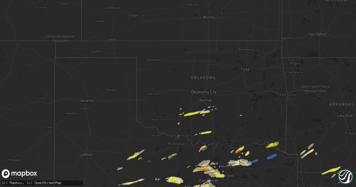
Hail Map in Oklahoma on April 4, 2022
Get this storm
April 4 map
$229
one time, instant access
Download today. No call, no setup
Keep the $229
Bought the map and want the full workflow? Apply the entire $229 to a subscription within 7 days. None of it is wasted.
Every map, not just this one
This buys you this map. Subscription and you get every map we run, in the markets you choose from a few cities to whole states to nationwide. Plus real-time alerts the moment a storm fires.
Contact data
Name, contact info, occupancy, even credit band for addresses in the footprint. You go from where it hit to who to call.
Become the source they trust
Unlimited branding weather history reports on demand. You already have the documented answer ready for the property owner, and you are the one who showed up with it.
Property data and RoofTrace estimates
Pull up any address you have got, its value and the exact code rules for that jurisdiction, straight from One Click Code. Then RoofTrace estimates the squares, pitch, and roof value, priced the way you price.
Storm reports in Oklahoma
Oklahoma
| Date | Description |
|---|---|
| 04/04/20221:25 PM CDT | On hwy 77. |
| 04/04/202212:15 PM CDT | A local report indicates 1.00 inch wind near 5 N LONE GROVE |
| 04/04/202212:00 PM CDT | A local report indicates 1.00 inch wind near 3 SSW LAKE ELLSWORTH |
| 04/04/20227:54 AM CDT | At 1254 PM CDT, a severe thunderstorm was located near Bradley, moving east at 40 mph. HAZARD...Quarter size hail. SOURCE...Radar indicated. IMPACT...Damage to vehicles is expected. Locations impacted include... Southern Norman, Purcell, Noble, Slaughterville, Lindsay, Lexington, Maysville, Wayne, Washington, Alex, Bradley, Criner, Payne and Erin Springs. |
| 04/04/20227:19 AM CDT | At 1218 PM CDT, a severe thunderstorm was located 5 miles northeast of Sterling, moving northeast at 40 mph. HAZARD...Quarter size hail. SOURCE...Radar indicated. IMPACT...Damage to vehicles is expected. Locations impacted include... Rush Springs, Dibble, Sterling, Cole, Alex, Bradley, Agawam, Criner, Ninnekah, Acme and Payne. |
| 04/04/20226:40 AM CDT | At 1139 AM CDT, a severe thunderstorm was located near Healdton, moving east at 30 mph. HAZARD...Quarter size hail. SOURCE...Radar indicated. IMPACT...Damage to vehicles is expected. Locations impacted include... Ardmore, Lone Grove, Healdton, Wilson, Dickson, Ringling, Springer, Gene Autry and Milo. |
| 04/04/20226:00 AM CDT | At 1100 PM CDT, a severe thunderstorm was located near Blossom, or 13 miles east of Paris, moving east at 40 mph. HAZARD...60 mph wind gusts and quarter size hail. SOURCE...Radar indicated. IMPACT...Hail damage to vehicles is expected. Expect wind damage to roofs, siding, and trees. Locations impacted include... Clarksville, Bagwell, Detroit, Annona, Negley, Bryarly and English. |
| 04/04/20224:44 AM CDT | At 943 PM CDT, a severe thunderstorm was located near Honey Grove, or 14 miles west of Paris, moving northeast at 30 mph. HAZARD...60 mph wind gusts and quarter size hail. SOURCE...Radar indicated. IMPACT...Hail damage to vehicles is expected. Expect wind damage to roofs, siding, and trees. Locations impacted include... Paris, Honey Grove, Blossom, Roxton, Toco and Sun Valley. |
| 04/04/20222:57 AM CDT | At 757 PM CDT, a severe thunderstorm was located 8 miles south of Muenster, or 13 miles southwest of Gainesville, moving east at 30 mph. HAZARD...60 mph wind gusts and quarter size hail. SOURCE...Radar indicated. IMPACT...Hail damage to vehicles is expected. Expect wind damage to roofs, siding, and trees. Locations impacted include... Gainesville, Muenster, Lindsay, Callisburg, Lake Kiowa and Valley View.This includes Interstate 35 between mile markers 483 and 503. |
| 04/04/20222:44 AM CDT | At 744 PM CDT, a severe thunderstorm was located over Ravenna, or near Bonham, moving northeast at 25 mph. HAZARD...60 mph wind gusts and quarter size hail. SOURCE...Radar indicated. IMPACT...Hail damage to vehicles is expected. Expect wind damage to roofs, siding, and trees. Locations impacted include... Bonham and Ravenna. |
| 04/04/20222:42 AM CDT | At 741 PM CDT, a severe thunderstorm was located over Leon, or 17 miles east of Nocona, moving northeast at 30 mph. HAZARD...65 mph wind gusts and half dollar size hail. SOURCE...Radar indicated. IMPACT...Hail damage to vehicles is expected. Expect wind damage to roofs, siding, and trees. This severe thunderstorm will remain over mainly rural areas of east central Montague and northwestern Cooke Counties. |
| 04/04/20222:27 AM CDT | At 727 PM CDT, a severe thunderstorm was located near Kemp, moving northeast at 20 mph. HAZARD...60 mph wind gusts and quarter size hail. SOURCE...Radar indicated. IMPACT...Hail damage to vehicles is expected. Expect wind damage to roofs, siding, and trees. Locations impacted include... Achille, Kemp, Hendrix, Blue, Utica, Albany and Wade. |
| 04/04/20222:17 AM CDT | At 717 PM CDT, a severe thunderstorm was located 4 miles northwest of St. Jo, moving northeast at 20 mph. HAZARD...Ping pong ball size hail and 60 mph wind gusts. SOURCE...Radar indicated. IMPACT...People and animals outdoors will be injured. Expect hail damage to roofs, siding, windows, and vehicles. Expect wind damage to roofs, siding, and trees. Locations impacted include... Leon, Rubottom and Burneyville. |
| 04/04/20222:03 AM CDT | At 703 PM CDT, a severe thunderstorm was located near St. Jo, or 8 miles southeast of Nocona, moving northeast at 30 mph. HAZARD...60 mph wind gusts and quarter size hail. SOURCE...Radar indicated. IMPACT...Hail damage to vehicles is expected. Expect wind damage to roofs, siding, and trees. Locations impacted include... St. Jo. |
| 04/04/202212:23 AM CDT | So reports large limbs down. |
| 04/03/202210:43 PM CDT | A local report indicates 1.00 inch wind near IDABEL |
| 04/03/202210:33 PM CDT | A local report indicates 1.00 inch wind near GARVIN |
| 04/03/20228:27 PM CDT | At 127 PM CDT, a severe thunderstorm was located near Wayne, moving east at 40 mph. HAZARD...Ping pong ball size hail. SOURCE...Radar indicated. IMPACT...People and animals outdoors will be injured. Expect damage to roofs, siding, windows, and vehicles. Locations impacted include... Wayne, Paoli, Asher, Wanette, Byars, St. Louis and Rosedale. |
All States Impacted by Hail Map on April 4, 2022
Cities Impacted by Hail Map on April 4, 2022
- Ravenna, TX
- Bonham, TX
- Ivanhoe, TX
- Savoy, TX
- Telephone, TX
- Fletcher, OK
- Rush Springs, OK
- Bradley, OK
- Ninnekah, OK
- Wolfe City, TX
- Gordon, TX
- Stephenville, TX
- Mingus, TX
- Coppell, TX
- Irving, TX
- Dallas, TX
- Carrollton, TX
- Burleson, TX
- De Kalb, MS
- Preston, MS
- Avon Park, FL
- Sebring, FL
- Frostproof, FL
- Del Rio, TX
- Hayneville, AL
- Brandon, MS
- Sardis, AL
- Minter, AL
- Tyler, AL
- Evergreen, AL
- McKenzie, AL
- Fulton, AR
- Ennis, TX
- Waxahachie, TX
- Palmer, TX
- Flower Mound, TX
- Punta Gorda, FL
- Sylvester, TX
- McCaulley, TX
- Roby, TX
- Alva, FL
- Labelle, FL
- Immokalee, FL
- Fort Myers, FL
- Lehigh Acres, FL
- Clewiston, FL
- Quitman, MS
- Venus, TX
- Weatherford, TX
- Lillian, TX
- Alvarado, TX
- Fort Worth, TX
- Joshua, TX
- Cleburne, TX
- Mansfield, TX
- Crowley, TX
- Cresson, TX
- Godley, TX
- Flowood, MS
- Pelahatchie, MS
- Morton, MS
- Desdemona, TX
- Ranger, TX
- Dublin, TX
- Meridian, TX
- Clifton, TX
- Silver City, MS
- Collinsville, MS
- Texarkana, AR
- Emmet, AR
- Hope, AR
- Zolfo Springs, FL
- Lake Wales, FL
- River Ranch, FL
- Kenansville, FL
- Toxey, AL
- Butler, AL
- Grandview, TX
- Lewisville, TX
- Wanette, OK
- Yazoo City, MS
- Belzoni, MS
- Tchula, MS
- Newark, TX
- Honey Grove, TX
- Arcadia, FL
- Wayne, OK
- Maysville, OK
- Maypearl, TX
- Breckenridge, TX
- Caddo, TX
- Kilmichael, MS
- Sweet Water, AL
- Uniontown, AL
- Dixons Mills, AL
- Arlington, AL
- Safford, AL
- Linden, AL
- Pine Hill, AL
- Thomaston, AL
- Faunsdale, AL
- Pennington, AL
- Catherine, AL
- Alberta, AL
- Magnolia, AL
- Celeste, TX
- Leonard, TX
- Waurika, OK
- Ringling, OK
- Strawn, TX
- Palo Pinto, TX
- Lowndesboro, AL
- Selma, AL
- Justin, TX
- Paradise, TX
- Springtown, TX
- Boyd, TX
- Decatur, TX
- Ponder, TX
- Bridgeport, TX
- Rhome, TX
- Nocona, TX
- Saint Jo, TX
- Fort Lauderdale, FL
- Paducah, TX
- Lone Grove, OK
- Healdton, OK
- Wilson, OK
- Ardmore, OK
- Grapevine, TX
- Southlake, TX
- Seymour, TX
- Shubuta, MS
- Blue Ridge, TX
- Farmersville, TX
- Holliday, TX
- Olney, TX
- Albany, TX
- Eustace, TX
- Mabank, TX
- Clarksville, TX
- Idabel, OK
- Valliant, OK
- Garvin, OK
- Tolar, TX
- Bluff Dale, TX
- Lipan, TX
- Lawton, OK
- Faxon, OK
- Athens, TX
- Murchison, TX
- Malakoff, TX
- Larue, TX
- Brownsboro, TX
- Chandler, TX
- Elgin, OK
- Lena, MS
- Needham, AL
- Thomasville, AL
- Orrville, AL
- Gilbertown, AL
- Scurry, TX
- Kemp, TX
- Ferris, TX
- Granbury, TX
- Italy, TX
- Milford, TX
- Itasca, TX
- Sherman, TX
- Denison, TX
- Bells, TX
- Carthage, MS
- Kaufman, TX
- Rosser, TX
- Ochopee, FL
- Madison, MS
- Ridgeland, MS
- Jackson, MS
- Canton, MS
- Mangham, LA
- Monroe, LA
- Columbia, LA
- West Monroe, LA
- Rayville, LA
- Commerce, TX
- Graford, TX
- Duncan, OK
- Junction City, AR
- El Dorado, AR
- Mayersville, MS
- Sondheimer, LA
- Vicksburg, MS
- Tallulah, LA
- Lexington, MS
- Cruger, MS
- Weinert, TX
- Little Elm, TX
- Midlothian, TX
- Wauchula, FL
- Denton, TX
- Argyle, TX
- Poolville, TX
- Starkville, MS
- Lindsay, OK
- Purcell, OK
- Paoli, OK
- Knox City, TX
- Roanoke, TX
- Trinidad, TX
- Aubrey, TX
- Red Oak, TX
- Richton, MS
- Muenster, TX
- Krum, TX
- Sanger, TX
- Strong, AR
- Haynesville, LA
- Monroeville, AL
- Rolling Fork, MS
- Naples, FL
- Anson, TX
- Lexington, OK
- Marion Junction, AL
- Lisman, AL
- Newton, MS
- Sweetwater, TX
- Santo, TX
- Euless, TX
- Haslet, TX
- Lake Dallas, TX
- Keller, TX
- Bedford, TX
- Chico, TX
- Colleyville, TX
- The Colony, TX
- Addison, TX
- Hurst, TX
- Alvord, TX
- Richardson, TX
- North Richland Hills, TX
- Cary, MS
- Melissa, TX
- Anna, TX
- Blevins, AR
- Prescott, AR
- Myakka City, FL
- Florence, MS
- Forreston, TX
- Chatfield, TX
- Haltom City, TX
- Keene, TX
- Aledo, TX
- Arlington, TX
- Kennedale, TX
- Pachuta, MS
- Vossburg, MS
- Dodd City, TX
- Vaiden, MS
- Stewart, MS
- Ladonia, TX
- Klondike, TX
- Princeton, TX
- Pahokee, FL
- South Bay, FL
- Mckinney, TX
- Cumby, TX
- Sulphur Springs, TX
- Greenville, TX
- Van Alstyne, TX
- Venus, FL
- Auburn, AL
- Opelika, AL
- Bagwell, TX
- Stamford, TX
- Windom, TX
- Forest, MS
- Heidelberg, MS
- Frisco City, AL
- Peterman, AL
- Sturgis, MS
- Louisville, MS
- Miami, FL
- Port Charlotte, FL
- Rosston, AR
- Centerville, TX
- Ogden, AR
- Apache, OK
- Jayton, TX
- Moore Haven, FL
- Plano, TX
- Homestead, FL
- French Camp, MS
- Eupora, MS
- Newcastle, TX
- Coalgate, OK
- Stuart, OK
- Randlett, OK
- Scooba, MS
- Cement, OK
- Walnut Grove, MS
- Fort Meade, FL
- Spearsville, LA
- Bernice, LA
- Lillie, LA
- Richland, MS
- Pearl, MS
- Ryan, OK
- Montague, TX
- Bentonia, MS
- Broken Bow, OK
- Coushatta, LA
- Ringgold, LA
- Shreveport, LA
- Frierson, LA
- Keithville, LA
- Elm Grove, LA
- Downsville, LA
- Choudrant, LA
- Sterlington, LA
- Farmerville, LA
- Windthorst, TX
- Cooper, TX
- Lake Creek, TX
- Bogata, TX
- Annona, TX
- Avery, TX
- Rice, TX
- Ben Wheeler, TX
- Canton, TX
- Flint, TX
- Tyler, TX
- Henderson, TX
- Whitehouse, TX
- Troup, TX
- Overton, TX
- Arp, TX
- Carthage, TX
- Okeechobee, FL
- Belle Glade, FL
- Archer City, TX
- Perrin, TX
- Jacksboro, TX
- Petty, TX
- Gallion, AL
- Washington, AR
- Hazlehurst, MS
- Crystal Springs, MS


