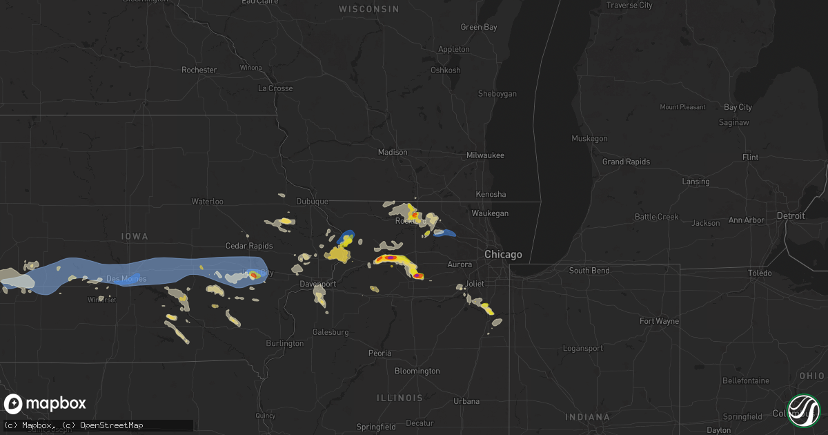
Hail Map on July 10, 2025
Get this storm
July 10 map
$229
one time, instant access
Download today. No call, no setup
Keep the $229
Bought the map and want the full workflow? Apply the entire $229 to a subscription within 7 days. None of it is wasted.
Every map, not just this one
This buys you this map. Subscription and you get every map we run, in the markets you choose from a few cities to whole states to nationwide. Plus real-time alerts the moment a storm fires.
Contact data
Name, contact info, occupancy, even credit band for addresses in the footprint. You go from where it hit to who to call.
Become the source they trust
Unlimited branding weather history reports on demand. You already have the documented answer ready for the property owner, and you are the one who showed up with it.
Property data and RoofTrace estimates
Pull up any address you have got, its value and the exact code rules for that jurisdiction, straight from One Click Code. Then RoofTrace estimates the squares, pitch, and roof value, priced the way you price.
States Impacted by Hail Map on July 10, 2025
Storm reports
Ohio
| Date | Description |
|---|---|
| 07/10/20253:05 PM CDT | Tree down on wire on west lake blvd between greenwood and merrill. Time estimated via radar. |
| 07/10/20252:48 PM CDT | Tree down across state route 5. |
| 07/10/20252:47 PM CDT | Local public safety scanner reported multiple trees and wires down across central portage county. Time estimated via radar. |
| 07/10/20251:50 PM CDT | Portion of a birch tree downed. Time estimated via radar. |
| 07/10/20251:46 PM CDT | Trees and wires downed around leavittsburg. |
Illinois
| Date | Description |
|---|---|
| 07/10/20256:03 PM CDT | Large branch of a bradford pear tree snapped. Time estimated by radar. |
| 07/10/20255:55 PM CDT | 6 inch tree limb downed on dietrich road in hampshire. Time estimated via radar. |
| 07/10/20255:55 PM CDT | Downed power lines resulting in power outages in the 100 block of terwilliger avenue. Time estimated by radar. |
| 07/10/20255:42 PM CDT | A local report indicates 2.00 inch wind near 4 NW Earlville |
| 07/10/20255:27 PM CDT | Report from mping: quarter |
| 07/10/20255:20 PM CDT | Multiple trees and power lines downed in cherry valley and on the southeast side of rockford. Time estimated from radar. |
| 07/10/20255:13 PM CDT | A local report indicates 1.00 inch wind near 4 NNW Cherry Valley |
| 07/10/20255:10 PM CDT | A local report indicates 1.50 inch wind near Machesney Park |
| 07/10/20255:10 PM CDT | Report from mping: quarter |
| 07/10/20255:05 PM CDT | Heavy hail from 5:00-5:10 pm. Varied in size with largest piece being 1.5in measured. No injuries and no obvious damage at this time. |
| 07/10/20254:56 PM CDT | Up to 6 diameter limbs down near brooklyn rd on rt 30. Corn fields also have corn blown at 35 to 40 degree angles. |
| 07/10/20254:55 PM CDT | Report from mping: quarter |
| 07/10/20254:47 PM CDT | Time estimated by radar. |
| 07/10/20254:27 PM CDT | Report from mping: hen egg |
| 07/10/20254:17 PM CDT | Report from mping: hen egg |
| 07/10/20254:14 PM CDT | Report from mping: half dollar |
| 07/10/20254:07 PM CDT | Report from mping: ping pong ball |
| 07/10/20253:56 PM CDT | A local report indicates 1.50 inch wind near 1 ESE Dixon |
| 07/10/20253:33 PM CDT | A local report indicates 1.25 inch wind near 2 N Nelson |
| 07/10/20253:28 PM CDT | A local report indicates 1.75 inch wind near 2 NE Nelson |
| 07/10/20257:35 AM CDT | Corrects previous tstm wnd dmg report from manteno |
| 07/09/202510:53 PM CDT | Depue fire reported trees and limbs down throughout town... Some of which were blocking roadways. They also reported minor flooding. Time estimated by radar. |
| 07/09/202510:20 PM CDT | Media in kewanee relayed a henry county sheriffs office report of a tree down on county highway 5 north of highway 81. Time estimated by radar. |
| 07/09/20258:11 PM CDT | Mping report of half dollar sized hail. |
| 07/09/20257:52 PM CDT | Measured at a personal weather station on the northwest side of manteno. |
| 07/09/20257:40 PM CDT | Quarter sized hail lasting for about ten minutes |
| 07/09/20257:40 PM CDT | Quarter sized hail lasting for about ten minutes. |
| 07/09/20257:40 PM CDT | Report of a lot of trees down throughout th |
| 07/09/20257:40 PM CDT | Report of a lot of trees down throughout this area. |
| 07/09/20257:35 PM CDT | Reports of several downed power lines |
| 07/09/20257:35 PM CDT | Corrects previous tstm wnd dmg report from 7 se symerton. Corrects previous tstm wnd dmg report from manteno |
| 07/09/20257:35 PM CDT | 5 downed power poles at 9000n and 3250w west of manteno. |
| 07/09/20257:30 PM CDT | Report of numerous power lines down... Power poles snapped... And trees down across roads. This damage is widespread throughout the area. |
| 07/09/20257:25 PM CDT | A local report indicates 1.25 inch wind near 1 ESE Savanna |
| 07/09/20257:20 PM CDT | 70 foot repeater tower knocked down due to high winds. |
| 07/09/20257:12 PM CDT | Dispatch reported multiple power poles and wires down... Leading to portions of route 84 being closed. Along the same route... Reports of several farm irrigators being |
Vermont
| Date | Description |
|---|---|
| 07/10/20255:24 PM CDT | Tree into power lines on route 100 north of hyde park. |
| 07/10/20254:57 PM CDT | Tree down onto south hill road in williamstown. |
| 07/10/20253:36 PM CDT | Roof damage to middlebury high school and a tree down. |
| 07/10/20253:32 PM CDT | Trees and wires down in middlebury. |
| 07/10/20253:27 PM CDT | Multiple trees down on route 125 |
| 07/10/20252:35 PM CDT | Broken pole with wires down. |
| 07/10/20252:25 PM CDT | Multiple trees down on vermont 17 |
| 07/10/20251:43 PM CDT | Photo received from the town clerk. |
Iowa
| Date | Description |
|---|---|
| 07/10/20256:44 PM CDT | Corrects previous tornado report from 1 nw ironhills. Video of a brief touchdown... No damage observed. |
| 07/10/20255:37 PM CDT | A local report indicates 1.00 inch wind near Iowa City |
| 07/10/20255:35 PM CDT | There was a 6-8 inch tree trunk snapped by thunderstorm winds. |
| 07/10/20251:28 AM CDT | A local report indicates 70 MPH wind near Altoona |
| 07/10/20251:08 AM CDT | 52 knot gust ankeny airport. |
| 07/10/202512:49 AM CDT | 64 knot gust dsm airport. |
| 07/10/202512:46 AM CDT | A local report indicates 64 MPH wind near 1 SE Clive |
| 07/10/202512:45 AM CDT | Mature tree snapped in ewing park. Time of occurrence estimated from radar. |
| 07/10/202512:39 AM CDT | Two sustained gusts to 70 mph at 1237 and 1240 am. |
| 07/10/202512:38 AM CDT | Estimated 60-70 mph gusts on the west side of town. |
| 07/10/202512:33 AM CDT | Estimated 50-60mph gusts. |
| 07/10/202512:13 AM CDT | Healthy... Mature tree knocked over. Numerous large 6+ diameter limbs snapped off also. |
| 07/09/202511:50 PM CDT | Large tree limb down. |
| 07/09/202511:45 PM CDT | Tree damage across much of the city. |
| 07/09/202511:45 PM CDT | Tree damage across much of the area. |
| 07/09/202511:45 PM CDT | Tree damage across much of the city. |
| 07/09/202510:49 PM CDT | A local report indicates 68 MPH wind near 5 S Harlan |
| 07/09/20259:17 PM CDT | Location and time estimated by radar. |
| 07/09/20257:48 PM CDT | Couple trees downed. One 2-3 feet in diameter downed onto a vehicle. |
| 07/09/20257:48 PM CDT | Couple trees downed. One 2-3 feet in diameter downed onto a vehicle. Time estimated. |
Georgia
| Date | Description |
|---|---|
| 07/10/20255:25 PM CDT | Tree down near 3300 stallings road. |
| 07/10/20255:16 PM CDT | Delayed report. Wayne county dispatch reported a tree down on west lake dr and griffis rd. |
| 07/10/20255:10 PM CDT | Chatham county em reported downed powerlines across the county. Police scanner broadcast within the city of savannah reported a tree blocking a road and at least one tr |
| 07/10/20255:02 PM CDT | A severe thunderstorm downed a power line near the intersection of coffee bluff road and ben kell road. Time determined from radar data. |
| 07/10/20255:01 PM CDT | Downed trees on whitley street. |
| 07/10/20255:00 PM CDT | A severe thunderstorm downed a power line near the 3200 block of cedar street. Time determined using radar data. |
| 07/10/20255:00 PM CDT | Downed trees reported in tift county. |
| 07/10/20254:55 PM CDT | Powerline reported down on elm street. Time determined from radar data. |
| 07/10/20254:49 PM CDT | Trees down. |
| 07/10/20254:46 PM CDT | A severe thunderstorm downed a power line at the 300 block of beaufort road. Time determined from radar data. |
| 07/10/20254:39 PM CDT | A severe thunderstorm downed a power line at the 2100 block of krenson street. Time determined from radar data. |
| 07/10/20254:22 PM CDT | Social media video showed a thunderstorm wind gust snapping several large limbs off a tree onto a driveway of a home. Time determined using radar data. |
| 07/10/20254:21 PM CDT | Several downed trees and powerlines on legg rd. |
Oklahoma
| Date | Description |
|---|---|
| 07/10/20256:35 PM CDT | A local report indicates 62 MPH wind near 3 SSE Boise City |
| 07/10/20256:05 PM CDT | A downburst event occurred near a feed lot 3 miles north of felt and affected some parts surrounding. Roofs at the lot and at surrounding houses were torn but not compl |
| 07/10/20256:02 PM CDT | Em reported windows knocked out of two cars in felt. Supports downburst with winds likely over 80 mph. |
| 07/10/20253:40 PM CDT | The first severe gust occurred at 3:35 pm and the final gust occurred at 3:45 pm. The peak was 67 mph. |
North Dakota
| Date | Description |
|---|---|
| 07/10/20256:56 PM CDT | Estimated time. Large hail lasted approximately 20 minutes. |
| 07/10/20256:52 PM CDT | Broadcast media relayed delayed report. |
| 07/10/20256:40 PM CDT | Softer hail... Lasted 3 minutes. |
| 07/10/20256:32 PM CDT | Broadcast media relayed report with picture. |
| 07/10/20256:30 PM CDT | A local report indicates 2.50 inch wind near 3 N Maxbass |
| 07/09/20258:00 PM CDT | Late report from last evening. Time based on radar. Mainly rain but a few quarters mixed in. |
New Mexico
| Date | Description |
|---|---|
| 07/10/20256:35 PM CDT | Awos station ksxu santa rosa airport. |
| 07/10/20255:15 PM CDT | Lots of blowing dust kicked up with reduced visibility. |
| 07/10/20254:44 PM CDT | A local report indicates 1.75 inch wind near 11 NNE Gladstone |
| 07/09/20257:35 PM CDT | Mesonet station wsm34 stallion wit |
North Carolina
| Date | Description |
|---|---|
| 07/10/20256:41 PM CDT | Several outages due to fallen trees on power lines. |
| 07/10/20256:30 PM CDT | A few hundred outages due to trees down on powerlines. |
| 07/10/20256:06 PM CDT | Tree uprooted and downed partially on a home. |
| 07/10/20255:50 PM CDT | Several hundred outages due to trees down on power lines. |
| 07/10/20252:50 PM CDT | Tree downed on perkins rd. |
Nebraska
| Date | Description |
|---|---|
| 07/10/20256:56 PM CDT | Mesonet site hayln1. Supported by radar data of a potential microburst in this area. |
| 07/10/20256:55 PM CDT | Image from social media of snapped power poles. |
| 07/10/20256:55 PM CDT | 8-10 inch in diameter tree branch limbs down. |
| 07/10/20256:51 PM CDT | Mesonet hayln1. |
| 07/10/20256:50 PM CDT | Social media report of several turned pivots as well as damage to a nearby grain silo. |
| 07/10/20256:37 PM CDT | Social media report of quarters with a few goofball sized hail in town. |
| 07/10/20256:37 PM CDT | Tree blown over onto house just south of the high school. Time estimated from radar and nearby mesonet reports. |
| 07/10/20256:35 PM CDT | Via davis weather station. |
| 07/10/20256:29 PM CDT | Via davis weather station. |
| 07/10/20256:27 PM CDT | Via davis weather station. |
| 07/10/20256:22 PM CDT | Ping pong to golf ball size hail at its peak caused damage to siding. |
| 07/10/20256:20 PM CDT | A local report indicates 1.00 inch wind near Wilcox |
| 07/10/20256:18 PM CDT | Report from mping: quarter . (o |
| 07/10/20256:18 PM CDT | Report from mping: quarter |
| 07/10/20256:17 PM CDT | Report from mping: quarter |
| 07/10/20256:17 PM CDT | A local report indicates 62 MPH wind near Grand Island Airport |
| 07/10/20256:15 PM CDT | Reports of structural damage and several reports of tree damage around town... Primarily on the north side of town. |
| 07/10/20256:15 PM CDT | A local report indicates 1.00 inch wind near Wilcox |
| 07/10/20256:04 PM CDT | Video of approximately 18 inch diameter tree limb down. Time estimated from radar. |
| 07/10/20255:58 PM CDT | Report from mping: half dollar |
| 07/10/20255:57 PM CDT | Report from mping: half dollar |
| 07/10/20255:40 PM CDT | A local report indicates 1.75 inch wind near 4 NE Neligh |
| 07/10/20254:45 PM CDT | Downed tree branches up to 7-8 inches in diameter. |
| 07/10/20253:35 PM CDT | (g |
| 07/10/20253:35 PM CDT | A local report indicates 1.00 inch wind near 6 NNE Orleans |
| 07/10/20253:27 PM CDT | Via davis weather station. |
| 07/09/20259:12 PM CDT | A few tree limbs down in town. |
| 07/09/20259:12 PM CDT | A few tree limbs down in town. (gi |
| 07/09/20258:54 PM CDT | Via personal weather station. |
| 07/09/20258:25 PM CDT | Report of 18 inch in diameter tree branch down. |
| 07/09/20258:20 PM CDT | A local report indicates 58 MPH wind near Holdrege Airport |
| 07/09/20257:50 PM CDT | A local report indicates 1.00 inch wind near Wilcox |
| 07/09/20257:50 PM CDT | A local report indicates 62 MPH wind near 1 N Oxford |
| 07/09/20257:45 PM CDT | Personal weather station. |
| 07/09/20257:36 PM CDT | A local report indicates 60 MPH wind near 2 NNE Hampton |
| 07/09/20257:23 PM CDT | A local report indicates 58 MPH wind near 1 SSE Aurora |
| 07/09/20257:14 PM CDT | A local report indicates 60 MPH wind near 2 W Aurora |
| 07/09/20257:12 PM CDT | Peak gust of 63 mph measured by asos. |
| 07/09/20257:12 PM CDT | Off duty nws employee reporting 50-60 mph wind gust. |
| 07/09/20257:08 PM CDT | Report from mping: quarter |
| 07/09/20257:04 PM CDT | A local report indicates 58 MPH wind near 5 WSW Hansen |
South Carolina
| Date | Description |
|---|---|
| 07/10/20256:20 PM CDT | Downed tree blocking the roadway at the intersection of browns ferry rd and pinewood dr. |
| 07/10/20255:03 PM CDT | The jasper county warning point reported a tree down on a power line on bellinger hill road. |
| 07/10/20254:40 PM CDT | Emergency manager reports roof damage to multiple buildings at 1098 joe s jeffords highway. |
| 07/10/20254:38 PM CDT | Emergency manager reports trees down near the intersection of charleston highway and stonewall jackson blvd. |
| 07/10/20254:14 PM CDT | Nws storm survey team determined that an ef0 tornado occurred within the savannah national wildlife refuge between 5:14 pm until 5:16 pm. The tornado had an estimated p |
| 07/10/20254:05 PM CDT | Tree fell on a vehicle near brimfield drive and west church street. |
| 07/10/20251:10 PM CDT | A local report indicates 1.00 inch wind near 4 NW Salem |
| 07/09/20257:20 PM CDT | Tree in roadway on sc410. |
| 07/09/20257:07 PM CDT | Tree in roadway on s65. |
| 07/09/20257:03 PM CDT | Tree in roadway on enoch rd |
| 07/09/20257:00 PM CDT | Tree in roadway on egg hill rd. |
South Dakota
| Date | Description |
|---|---|
| 07/10/202510:56 AM CDT | A local report indicates 58 MPH wind near 3 NW Wasta |
| 07/10/20259:21 AM CDT | A local report indicates 1.00 inch wind near 2 W Piedmont |
Colorado
| Date | Description |
|---|---|
| 07/10/20255:30 PM CDT | A local report indicates 60 MPH wind near 5 NNW Heartstrong |
| 07/10/20255:30 PM CDT | A local report indicates 60 MPH wind near 5 S Burlington |
| 07/10/20254:46 PM CDT | A local report indicates 62 MPH wind near 3 ESE Falcon |
| 07/10/20254:39 PM CDT | A local report indicates 60 MPH wind near 2 N Falcon |
| 07/10/20254:25 PM CDT | A local report indicates 60 MPH wind near 5 WNW Peyton |
| 07/10/20254:24 PM CDT | A local report indicates 58 MPH wind near 8 NNW Flagler |
| 07/10/20253:42 PM CDT | A local report indicates 58 MPH wind near 2 SE Denver Intl Airpor |
| 07/10/20253:42 PM CDT | A local report indicates 58 MPH wind near Denver Intl Airport |
| 07/10/20253:30 PM CDT | Mesonet station e470 & 6th avenue. |
| 07/10/20253:17 PM CDT | Corrects previous non-tstm wnd gst report from 3 sw commerce city. Mesonet station co207 denver i-70/york st. |
| 07/10/20253:17 PM CDT | Cdot weath |
| 07/10/20253:17 PM CDT | Mesonet station co205 denver i-70/colorado. |
| 07/10/20253:17 PM CDT | Cdot weather sensor at i-25 and yor |
| 07/10/20253:17 PM CDT | Cdot weather sensor at i-25 and york st. |
| 07/10/20253:16 PM CDT | Corrects previous non-tstm wnd gst report from 3 n denver. Mesonet station co210 denver i-70/washington. |
| 07/10/20253:16 PM CDT | Cdot weather sensor i-25 and washington. |
| 07/10/20252:55 PM CDT | Mesonet station dvi09234 arvada. |
| 07/10/20252:46 PM CDT | National wind technology center. |
| 07/10/202511:45 AM CDT | Mesonet station gw3678 pueblo west. |
| 07/09/20259:42 PM CDT | Site rmr ranch measured a 76 mph wind gust. |
Texas
| Date | Description |
|---|---|
| 07/10/20256:44 PM CDT | A local report indicates 61 MPH wind near 12 SW Dalhart |
New York
| Date | Description |
|---|---|
| 07/10/20256:53 PM CDT | Tree downed and across vly summit road. |
| 07/10/20256:50 PM CDT | Trees and wires downed on county route 74 in easton. |
| 07/10/20256:28 PM CDT | Corrects previous tstm wnd dmg report from 3 ne saratoga springs. Social media report received of a tree down on a fence along liz ann drive near saratoga springs. |
| 07/10/20256:27 PM CDT | Tree downed on the northway southbound within the area of exit 14... New york route 9p and new york route 29 in saratoga springs. |
| 07/10/20256:25 PM CDT | A local report indicates 1.00 inch wind near Saratoga Springs |
| 07/10/20256:20 PM CDT | Trees downed on goodman road. |
| 07/10/20255:59 PM CDT | A local report indicates 62 MPH wind near 3 NE Glens Falls |
| 07/10/20252:20 PM CDT | Several reports of wires downed and on a structure on copeland pond road and hadlock pond road. |
| 07/09/20257:28 PM CDT | Social media report received of a tree down on a fence along liz ann drive near saratoga springs. |
| 07/09/20257:17 PM CDT | Trees and wires reported down in hoosick falls. |
| 07/09/20257:17 PM CDT | Wires reported down on lincoln hill road in the town of white creek. |
| 07/09/20257:15 PM CDT | Tree downed and across north old state road. |
| 07/09/20257:09 PM CDT | Several trees reported down throughout the town of cambridge... Some of which occurred along center cambridge road. |
| 07/09/20257:05 PM CDT | Trees downed on county route 59. |
Kansas
| Date | Description |
|---|---|
| 07/10/20256:57 PM CDT | Social media report of wind gusts up to 70 mph. |
| 07/10/20256:41 PM CDT | Mesonet station up840 9.0 w winona |
| 07/10/20254:03 PM CDT | A local report indicates 83 MPH wind near 1 SW Garden City |
| 07/10/20253:57 PM CDT | A local report indicates 60 MPH wind near 2 ENE Garden City |
| 07/10/20253:35 PM CDT | Awos station kuls ulysses. |
| 07/10/20253:33 PM CDT | A local report indicates 1.00 inch wind near Ulysses |
| 07/10/20253:05 PM CDT | A local report indicates 1.00 inch wind near 6 WNW Friend |
| 07/09/20258:10 PM CDT | Ambient weather network site videra_weather. |
| 07/09/20258:01 PM CDT | A local report indicates 67 MPH wind near 2 E Shallow Water |
| 07/09/20257:55 PM CDT | Awos station kjhn johnson city. |
| 07/09/20257:55 PM CDT | Awos station k36k 2 n lakin. |
| 07/09/20257:47 PM CDT | Site landfill office measure 58 mph wind gust. |
| 07/09/20257:39 PM CDT | Personal weather station kkslakin28. |
| 07/09/20257:38 PM CDT | Ambient weather network site nwkecounty. |
| 07/09/20257:31 PM CDT | Mesonet d5288. |
| 07/09/20257:30 PM CDT | A local report indicates 61 MPH wind near 1 ESE Kendall |
| 07/09/20257:18 PM CDT | Media storm chaser is reporting gusts of 50 to 60 mph. |
| 07/09/20257:15 PM CDT | Mesonet k5coo. |
| 07/09/20257:15 PM CDT | Awos station k3k3 syracuse. |
| 07/09/20257:09 PM CDT | Report from mesonet station. |
Wisconsin
| Date | Description |
|---|---|
| 07/10/20254:40 PM CDT | Pictures from social media indicating numerous large branches down across town. Time estimated from radar. |
Cities Impacted by Hail Map on July 10, 2025
- Brainerd, MN
- Newell, SD
- Vale, SD
- Pierz, MN
- Spalding, NE
- Whitewood, SD
- Sturgis, SD
- Primrose, NE
- Deadwood, SD
- Lead, SD
- Albion, NE
- Nemo, SD
- Piedmont, SD
- Black Hawk, SD
- Rapid City, SD
- Keystone, SD
- Newman Grove, NE
- Lindsay, NE
- Wasta, SD
- Pueblo, CO
- Celina, TX
- Little Elm, TX
- Frisco, TX
- Mckinney, TX
- Prosper, TX
- Miami, FL
- Macon, GA
- Lizella, GA
- Tamassee, SC
- Sebring, FL
- Norfolk, NE
- Bristolville, OH
- Warren, OH
- Southington, OH
- West Farmington, OH
- Orleans, VT
- Hoskins, NE
- Stanton, NE
- Camden, NC
- Leavittsburg, OH
- Randolph, NE
- Castle Rock, CO
- Franktown, CO
- McIntyre, GA
- Milledgeville, GA
- Niobrara, NE
- Gay, GA
- Bloomfield, NE
- Soperton, GA
- Tarrytown, GA
- Saint Cloud, FL
- Kenansville, FL
- Greenville, GA
- Woodbury, GA
- Thomaston, GA
- Middlebury, VT
- Vergennes, VT
- Fellsmere, FL
- Glenwood, GA
- Ramah, CO
- Yatesville, GA
- New Haven, VT
- East Dublin, GA
- Ravenna, OH
- Saint Francisville, LA
- Jackson, LA
- Palm Bay, FL
- Golden, CO
- Arvada, CO
- Broomfield, CO
- Wheat Ridge, CO
- Deerfield, KS
- Holcomb, KS
- Vero Beach, FL
- Westminster, CO
- Denver, CO
- Aurora, CO
- Commerce City, CO
- Henderson, CO
- Dupont, CO
- Garden City, KS
- Oxford, NE
- Stamford, NE
- Simla, CO
- McRae Helena, GA
- Orleans, NE
- Bridport, VT
- Wagon Mound, NM
- Matheson, CO
- Ruth, MS
- Alamo, GA
- Lakin, KS
- Punta Gorda, FL
- Alma, NE
- Republican City, NE
- Dixon, IL
- Clinton, SC
- Kinards, SC
- Mount Morris, NY
- Nunda, NY
- Arcadia, FL
- Ulysses, KS
- Milan, GA
- Newton, GA
- Abbeville, GA
- Statesboro, GA
- Clayton, NM
- Rock Falls, IL
- Sterling, IL
- Port Wentworth, GA
- Rincon, GA
- Manns Harbor, NC
- Stumpy Point, NC
- Baconton, GA
- Whitmire, SC
- Naples, FL
- Rhine, GA
- Guyton, GA
- Dansville, NY
- Sublette, KS
- Satanta, KS
- Johnson, KS
- Pierceville, KS
- Ingalls, KS
- Franklin Grove, IL
- Orangeville, IL
- Rock City, IL
- Davis, IL
- Goodwell, OK
- Bloomingdale, GA
- Leary, GA
- Spartanburg, SC
- Springer, NM
- Watkins, CO
- Brighton, CO
- Bennett, CO
- Strasburg, CO
- Byers, CO
- Deer Trail, CO
- Rockford, IL
- Rockton, IL
- Ashburn, GA
- Amherst, CO
- Ashton, IL
- Rochelle, GA
- Danielsville, GA
- Commerce, GA
- Claxton, GA
- Gladstone, NM
- Boise City, OK
- Port Saint Lucie, FL
- Edgefield, SC
- Roscoe, IL
- Copeland, KS
- Cimarron, KS
- Dighton, KS
- Beeler, KS
- Jetmore, KS
- Des Moines, NM
- Clearwater, NE
- Champion, NE
- Keswick, IA
- Durand, IL
- Pecatonica, IL
- Parnell, IA
- Williamsburg, IA
- Royal, NE
- Ewing, NE
- Orchard, NE
- Grenville, NM
- Pierce, NE
- Rebecca, GA
- Pella, IA
- Holyoke, CO
- Otley, IA
- Mclean, NE
- Osmond, NE
- Genoa, CO
- Hugo, CO
- Arriba, CO
- Joes, CO
- Cope, CO
- Seibert, CO
- Vona, CO
- Flagler, CO
- Stratton, CO
- Dodge City, KS
- Loves Park, IL
- Machesney Park, IL
- Caledonia, IL
- Oxford, IA
- Wellman, IA
- Tifton, GA
- Fitzgerald, GA
- New Sharon, IA
- Green Pond, SC
- Ravenna, NE
- Shelton, NE
- Cairo, NE
- Meigs, GA
- Pelham, GA
- Orangeburg, SC
- Webster, IA
- Saint Matthews, SC
- Leighton, IA
- Hardeeville, SC
- Savannah, GA
- Russell, IA
- West Brooklyn, IL
- Salisbury, VT
- Cowpens, SC
- Chula, GA
- Neligh, NE
- Brunswick, NE
- Cohocton, NY
- Hornell, NY
- Chariton, IA
- Venango, NE
- Imperial, NE
- Brooklyn, IA
- Oskaloosa, IA
- South English, IA
- Harper, IA
- Ocilla, GA
- Winnebago, IL
- Shirland, IL
- Bluffton, SC
- Iowa City, IA
- Bethune, CO
- Burlington, CO
- Idalia, CO
- Kirk, CO
- Cuervo, NM
- Newkirk, NM
- Canandaigua, NY
- Fort Stewart, GA
- Richmond Hill, GA
- Sigourney, IA
- Hayesville, IA
- Norman Park, GA
- Kalona, IA
- Deep River, IA
- Victor, IA
- Guernsey, IA
- Melrose, IA
- Ellabell, GA
- North English, IA
- Saint Libory, NE
- Grand Island, NE
- Albia, IA
- Wood River, NE
- Hedrick, IA
- Little Mountain, SC
- Prosperity, SC
- Beacon, IA
- Las Vegas, NM
- Tiffin, IA
- Coralville, IA
- Garrett, WY
- Midway, GA
- Iliff, CO
- Sterling, CO
- Archer, NE
- Chapman, NE
- Central City, NE
- Ollie, IA
- Axson, GA
- Palmer, NE
- Carr, CO
- Nunn, CO
- Granite Canon, WY
- Cheyenne, WY
- Amboy, IL
- Oakdale, NE
- Tilden, NE
- Plainview, NE
- Kanorado, KS
- Saint Francis, KS
- Goodland, KS
- Creighton, NE
- Winnetoon, NE
- Monticello, IA
- Earlville, IL
- Genoa, IL
- Compton, IL
- Moravia, IA
- Garden Prairie, IL
- Belvidere, IL
- Poplar Grove, IL
- Capron, IL
- Kingston, IL
- What Cheer, IA
- Kirkland, IL
- Steward, IL
- Cherry Valley, IL
- Meadow Grove, NE
- Hampshire, IL
- Marengo, IL
- Huntley, IL
- Gilberts, IL
- Yuma, CO
- Eckley, CO
- Alda, NE
- Doniphan, NE
- Anamosa, IA
- Richland, IA
- Gill, CO
- Greeley, CO
- Paw Paw, IL
- Cascade, IA
- Dalhart, TX
- Petersburg, NE
- Briggsdale, CO
- Santa Rosa, NM
- Fort Sumner, NM
- Elgin, IL
- Battle Creek, NE
- Edson, KS
- Winona, KS
- Brewster, KS
- Colby, KS
- Elbert, CO
- Colorado Springs, CO
- Peyton, CO
- Calhan, CO
- Yoder, CO
- Rush, CO
- Verdigre, NE
- Platte Center, NE
- Felt, OK
- Moultrie, GA
- Toddville, IA
- Marion, IA
- Cedar Rapids, IA
- Monroe, NE
- Minooka, IL
- Central City, IA
- Coggon, IA
- Kersey, CO
- Eaton, CO
- Genoa, NE
- Humphrey, NE
- Unionville, IA
- Maxbass, ND
- Lone Tree, IA
- Mendota, IL
- Riverside, IA
- Wallace, KS
- Levant, KS
- Saint Edward, NE
- Naylor, GA
- Robins, IA
- Wilcox, NE
- Dyersville, IA
- New Vienna, IA
- Brighton, IA
- Fairfield, IA
- Westhope, ND
- Antler, ND
- Fullerton, NE
- Baldwyn, MS
- Bloomfield, NY
- Townsend, GA
- Ludowici, GA
- Riceboro, GA
- Columbus Junction, IA
- Nichols, IA
- Conesville, IA
- Elgin, NE
- Packwood, IA
- Adams Run, SC
- Saratoga Springs, NY
- Phillips, NE
- Boone, CO
- Ordway, CO
- Channahon, IL
- Minden, NE
- Newburg, ND
- Funk, NE
- Axtell, NE
- Lockridge, IA
- Hildreth, NE
- Calamus, IA
- Wheatland, IA
- Grand Mound, IA
- Beloit, WI
- Page, NE
- Heartwell, NE
- Drakesville, IA
- Waycross, GA
- Wray, CO
- Wilmington, IL
- Farley, IA
- Kenesaw, NE
- Lovilia, IA
- Ravenel, SC
- Schuylerville, NY
- Stillwater, NY
- Lost Nation, IA
- Bernard, IA
- Hiawatha, IA
- Greenwich, NY
- Johnsonville, NY
- Valley Falls, NY
- Schaghticoke, NY
- Buskirk, NY
- Cambridge, NY
- Upham, ND
- Hollywood, SC
- Gibbon, NE
- Eddyville, IA
- Bartlett, NE
- Queensbury, NY
- Hudson Falls, NY
- Glens Falls, NY
- Fort Ann, NY
- Mohall, ND
- Kramer, ND
- Souris, ND
- McDonald, KS
- Hendley, NE
- Pierce, CO
- Bantry, ND
- Willow City, ND
- Drake, ND
- Johnson, VT
- Manteno, IL
- Barton, VT
- Irasburg, VT
- Thomson, IL
- Brunswick, GA
- Galeton, CO
- Teeds Grove, IA
- Sabula, IA
- Clinton, IA
- Naponee, NE
- Manhattan, IL
- Underhill, VT
- Stowe, VT
- Jeffersonville, VT
- Harvey, ND
- Martin, ND
- Anamoose, ND
- Savanna, IL
- Ottumwa, IA
- Bird City, KS
- Juniata, NE
- Hastings, NE
- Atwood, KS
- Bryant, IA
- Mount Carroll, IL
- Wilsonville, NE
- Homerville, GA
- Bourbonnais, IL
- Goose Lake, IA
- Manor, GA
- Fulton, IL
- Norton, KS
- Beaver City, NE
- Morrison, IL
- De Witt, IA
- Chadwick, IL
- Kankakee, IL
- Preston, IA
- Guntown, MS
- Mantachie, MS
- Bellevue, IA
- Bradley, IL
- Silver Creek, NE
- Giltner, NE
- Almena, KS
- Holdrege, NE
- Atlanta, NE
- Onslow, IA
- Center Junction, IA
- Aurora, NE
- Saint Anne, IL
- Raleigh, NC
- Blue Springs, MS
- Ecru, MS
- Lowden, IA
- Oregon, IL
- Mount Morris, IL
- Dixon, IA
- Pender, NE
- Bancroft, NE
- Polo, IL
- Bennett, IA
- Wilton, IA
- Lyndon, IL
- Chana, IL
- Hampton, NE
- Momence, IL
- Gem, KS
- Rexford, KS
- Monument, KS
- Tampico, IL
- Durant, IA
- Stockton, IA
- Chambers, NE
- Prophetstown, IL
- Madison, NE
- Walcott, IA
- New Liberty, IA
- Kearney, NE
- Harmon, IL
- Wisner, NE
- Springfield, SD
- Miles, IA
- Spragueville, IA
- Pembroke Township, IL
- Deer Grove, IL
- Albany, IL
- Camanche, IA
- Fenton, IL
- Low Moor, IA
- Long Island, KS
- Charlotte, IA
- Wagner, SD
- Knoxville, IA
- Harvey, IA
- Lake Placid, NY
- Bloomingdale, NY
- Wayne, NE
- Walnut, IL
- Sheffield, IL
- Grover, CO
- Pilger, NE
- Esmond, IL
- Manlius, IL
- Princeton, IL
- Wyanet, IL
- Logan, IA
- Milledgeville, IL
- Milan, IL
- Rock Island, IL
- Eagle Bridge, NY
- Long Grove, IA
- Neeses, SC
- Clifton, IL
- Portsmouth, IA
- Persia, IA
- Aledo, IL
- Sherrard, IL
- Coal Valley, IL
- Orion, IL
- McCausland, IA
- Irwin, IA
- Kirkman, IA
- Shelby, IA
- New Windsor, IL
- Lynn Center, IL
- Sheridan, IL
- Harlan, IA
- Panama, IA
- Neola, IA
- Minden, IA
- Atkinson, IL
- Kewanee, IL
- Audubon, IA
- Hoisington, KS
- Elm Creek, NE
- Saranac Lake, NY
- Alpha, IL
- Avoca, IA
- Manning, IA
- Loomis, NE
- Ansley, NE
- Dodge, NE
- Omaha, NE
- West Point, NE
- Scribner, NE
- Douglas, WY
- Howells, NE
- Elk Horn, IA
- Marne, IA
- Walnut, IA
- Cameron, SC
- Bunker Hill, KS
- Bennington, NE
- Elkhorn, NE
- Boys Town, NE
- Bennettsville, SC
- Atlantic, IA
- Wiota, IA
- Brayton, IA
- Exira, IA
- Anita, IA
- Adair, IA
- Kimballton, IA
- Hamlin, IA
- Guthrie Center, IA
- Coon Rapids, IA
- Bayard, IA
- Lance Creek, WY
- Keene, NY
- La Vista, NE
- Letts, IA
- Snyder, NE
- Casey, IA
- Hooper, NE
- Pritchett, CO
- Woodbine, IA
- Upland, NE
- Hancock, IA
- Crescent, IA
- Kenton, OK
- Menlo, IA
- Stuart, IA
- Moline, IL
- Beemer, NE
- Panora, IA
- Lusk, WY
- Missouri Valley, IA
- Shawnee, WY
- Lost Springs, WY
- Redfield, IA
- Davenport, IA
- Ainsworth, IA
- Washington, IA
- Norcatur, KS
- Earlham, IA
- Delmar, IA
- Adel, IA
- Keota, IA
- Carter Lake, IA
- Council Bluffs, IA
- Manville, WY
- West Chester, IA
- Winterset, IA
- Tupelo, MS
- Linden, IA
- Bagley, IA
- Yale, IA
- Minburn, IA
- Perry, IA
- Jamaica, IA
- Dawson, IA
- Dallas Center, IA
- Van Meter, IA
- De Soto, IA
- Waukee, IA
- Des Moines, IA
- Grimes, IA
- Clive, IA
- West Des Moines, IA
- Urbandale, IA
- Cumming, IA
- Norwalk, IA
- Elkhart, IA
- Granger, IA
- Johnston, IA
- Altoona, IA
- Ankeny, IA
- Polk City, IA
- Woodward, IA
- Bondurant, IA
- Windsor Heights, IA
- Berwick, IA
- Dexter, IA
- Prole, IA
- Pleasant Hill, IA
- Mitchellville, IA
- Carlisle, IA
- Prairie City, IA
- Runnells, IA
- Trumbull, NE
- Dorrance, KS
- Holstein, NE
- Monroe, IA
- Colfax, IA
- Mingo, IA
- Baxter, IA
- Maxwell, IA
- Ira, IA
- Newton, IA
- Boston, GA
- Pavo, GA
- Dixie, GA
- Kennard, NE
- Tillman, SC
- Pembroke, GA
- Fleming, GA
- Blair, NE
- Fort Calhoun, NE
- New Bedford, IL
- Montezuma, IA
- Ladora, IA
- Killduff, IA
- Reasnor, IA
- Sully, IA
- Kellogg, IA
- Lynnville, IA
- Searsboro, IA
- Grinnell, IA
- Malcom, IA
- Laurel, IA
- Gilman, IA
- Millersburg, IA
- Conroy, IA
- Hartwick, IA
- Marengo, IA
- Chelsea, IA
- Belle Plaine, IA
- South Amana, IA
- Homestead, IA
- Middle Amana, IA
- Amana, IA
- Fairfax, IA
- Solon, IA
- North Liberty, IA
- Swisher, IA
- Hills, IA
- Center Conway, NH
- Lovell, ME
- West Branch, IA
- West Liberty, IA
- Stoneham, ME
- Tipton, IA
- Keyes, OK
- Bethel, ME
- Guildhall, VT
- Mechanicsville, IA
- Holly, CO
- Syracuse, KS
- Coolidge, KS
- Kendall, KS
- Marienthal, KS
- Scott City, KS
- Leoti, KS
- Norway, ME
- North Stratford, NH
- Healy, KS
- South Paris, ME
- Hebron, ME
- Taiban, NM
- Minot, ME
- Turner, ME