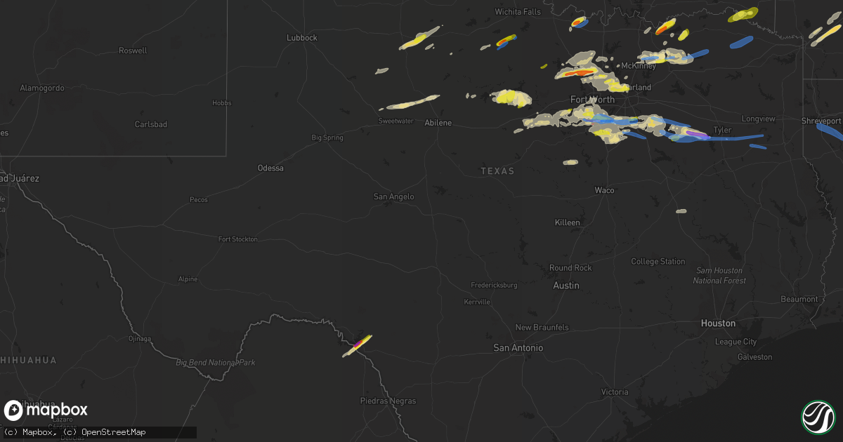
Hail Map in Texas on April 4, 2022
Get this storm
April 4 map
$229
one time, instant access
Download today. No call, no setup
Keep the $229
Bought the map and want the full workflow? Apply the entire $229 to a subscription within 7 days. None of it is wasted.
Every map, not just this one
This buys you this map. Subscription and you get every map we run, in the markets you choose from a few cities to whole states to nationwide. Plus real-time alerts the moment a storm fires.
Contact data
Name, contact info, occupancy, even credit band for addresses in the footprint. You go from where it hit to who to call.
Become the source they trust
Unlimited branding weather history reports on demand. You already have the documented answer ready for the property owner, and you are the one who showed up with it.
Property data and RoofTrace estimates
Pull up any address you have got, its value and the exact code rules for that jurisdiction, straight from One Click Code. Then RoofTrace estimates the squares, pitch, and roof value, priced the way you price.
Storm reports in Texas
Texas
| Date | Description |
|---|---|
| 04/04/20226:55 PM CDT | A local report indicates 1.00 inch wind near LAKE VIEW |
| 04/04/20226:55 PM CDT | A local report indicates 1.25 inch wind near 4 WNW LAKE VIEW |
| 04/04/20226:45 PM CDT | A local report indicates 1.50 inch wind near LAKE VIEW |
| 04/04/20226:35 PM CDT | Quarter size hail |
| 04/04/20226:41 AM CDT | At 1141 PM CDT, severe thunderstorms were located along a line extending from 10 miles northeast of Clarksville to near Wilkerson to near Purley, moving east at 35 mph. HAZARD...60 mph wind gusts and quarter size hail. SOURCE...Radar indicated. IMPACT...Hail damage to vehicles is expected. Expect wind damage to roofs, siding, and trees. Locations impacted include... Mount Pleasant, Clarksville, Boxelder, Mount Vernon, De Kalb, Naples, Omaha, Us 259 And I 30 Intersection, Cookville, Wilkerson, Purley, Dalby Springs, Cason, Winfield, Talco, Avery, Annona, Haworth, Miller's Cove and Moon. |
| 04/04/20226:28 AM CDT | At 1128 PM CDT, severe thunderstorms were located along a line extending from near Oak Leaf to near Grandview, moving east at 40 mph. HAZARD...65 mph wind gusts and quarter size hail. SOURCE...Radar indicated. IMPACT...Hail damage to vehicles is expected. Expect wind damage to roofs, siding, and trees. Locations impacted include... Grand Prairie, Mansfield, Cedar Hill, Lancaster, Waxahachie, Ennis, Midlothian, Glenn Heights, Red Oak, Ovilla, Venus, Ferris, Palmer, Italy, Grandview, Oak Leaf, Maypearl, Bardwell, Alma and Garrett.This includes the following highways... Interstate 35W between mile markers 11 and 19. Interstate 35E between mile markers 383 and 411. Interstate 45 between mile markers 244 and 266. |
| 04/04/20226:07 AM CDT | At 1106 PM CDT, severe thunderstorms were located along a line extending from 9 miles southwest of Deport to 6 miles northeast of Sulphur Springs, moving east at 45 mph. HAZARD...60 mph wind gusts and quarter size hail. SOURCE...Radar indicated. IMPACT...Hail damage to vehicles is expected. Expect wind damage to roofs, siding, and trees. Locations impacted include... Mount Pleasant, Hagansport, Boxelder, Mount Vernon, Bogata, Wilkerson, Winfield, Talco, Miller's Cove, Harts Bluff, Johntown and Cuthand. |
| 04/04/20225:49 AM CDT | At 1048 PM CDT, a severe thunderstorm was located over Burleson, moving east at 35 mph. HAZARD...65 mph wind gusts and quarter size hail. SOURCE...Radar indicated. IMPACT...Hail damage to vehicles is expected. Expect wind damage to roofs, siding, and trees. Locations impacted include... Dallas, Fort Worth, Arlington, Grand Prairie, Mansfield, Desoto, Cedar Hill, Duncanville, Burleson, Lancaster, Waxahachie, Cleburne, Benbrook, Midlothian, Crowley, Forest Hill, Glenn Heights, Red Oak, Kennedale and Everman. |
| 04/04/20225:40 AM CDT | At 1039 PM CDT, a severe thunderstorm was located over University Park, moving southeast at 20 mph. HAZARD...Quarter size hail. SOURCE...Radar indicated. IMPACT...Damage to vehicles is possible. Locations impacted include... Dallas, Garland, Irving, Mesquite, Carrollton, Richardson, Rowlett, Wylie, Rockwall, Farmers Branch, Balch Springs, University Park, Sachse, Addison, Highland Park, Hutchins, Heath, Fate, Sunnyvale and Wilmer. |
| 04/04/20225:25 AM CDT | At 1024 PM CDT, a severe thunderstorm was located 9 miles west of Idabel, or 19 miles north of Clarksville, moving northeast at 30 mph. HAZARD...60 mph wind gusts and quarter size hail. SOURCE...Radar indicated. IMPACT...Hail damage to vehicles is expected. Expect wind damage to roofs, siding, and trees. Locations impacted include... Idabel, Broken Bow, Garvin, Farmers Hill, Holly Creek, Glover, Albion, Oak Hill, Golden and Silver City. |
| 04/04/20225:16 AM CDT | At 1015 PM CDT, a severe thunderstorm was located near Annetta, or 11 miles southeast of Weatherford, moving east at 30 mph. HAZARD...60 mph wind gusts and quarter size hail. SOURCE...Radar indicated. IMPACT...Hail damage to vehicles is expected. Expect wind damage to roofs, siding, and trees. Locations impacted include... Fort Worth, Burleson, Benbrook, White Settlement, Crowley, River Oaks, Everman, Joshua, Edgecliff Village, Aledo, Westworth Village, Annetta, Cross Timber, Edgecliff, Westover Hills, Annetta South, Annetta North and Briaroaks.This includes the following highways... Interstate 35W between mile markers 34 and 53. Interstate 20 between mile markers 420 and 438. Interstate 30 between mile markers 1 and 16. |
| 04/04/20225:06 AM CDT | At 1005 PM CDT, a severe thunderstorm was located over Wolfe City, or 10 miles northwest of Commerce, moving east at 40 mph. HAZARD...65 mph wind gusts and half dollar size hail. SOURCE...Radar indicated. IMPACT...Hail damage to vehicles is expected. Expect wind damage to roofs, siding, and trees. Locations impacted include... Greenville, Sulphur Springs, Commerce, Cooper, Wolfe City, Cumby, Campbell, Deport, Cooper Lake Park South Sulphur, Cooper Lake Park Doctors Creek, Roxton, Ladonia, Tira, Pecan Gap and Neylandville.This includes Interstate 30 between mile markers 111 and 142. |
| 04/04/20224:45 AM CDT | At 945 PM CDT, severe thunderstorms were located along a line extending from Grapevine to Fort Worth, moving east at 25 mph. HAZARD...60 mph wind gusts and quarter size hail. SOURCE...Radar indicated. IMPACT...Hail damage to vehicles is expected. Expect wind damage to roofs, siding, and trees. Locations impacted include... Dallas, Fort Worth, Arlington, Garland, Irving, Grand Prairie, Carrollton, Richardson, Flower Mound, Rowlett, Euless, Bedford, Grapevine, Haltom City, Wylie, Keller, Coppell, Hurst, Farmers Branch and Southlake.This includes the following highways... Interstate 35W between mile markers 55 and 56. Interstate 35E between mile markers 424 and 445. Interstate 30 between mile markers 31 and 51. Interstate 45 between mile markers 282 and 284. |
| 04/04/20224:24 AM CDT | At 924 PM CDT, a severe thunderstorm was located over Anna, or 9 miles northeast of McKinney, moving east at 30 mph. HAZARD...60 mph wind gusts and nickel size hail. SOURCE...Radar indicated. IMPACT...Expect damage to roofs, siding, and trees. Locations impacted include... McKinney, Greenville, Anna, Princeton, Farmersville, Van Alstyne, Howe, Leonard, Whitewright, Wolfe City, Celeste, Bailey, Melissa, Blue Ridge, Trenton, New Hope, Weston and Westminster. |
| 04/04/20224:16 AM CDT | At 915 PM CDT, a severe thunderstorm was located over Bartonville, or near Trophy Club, moving east at 25 mph. HAZARD...60 mph wind gusts and half dollar size hail. SOURCE...Radar indicated. IMPACT...Hail damage to vehicles is expected. Expect wind damage to roofs, siding, and trees. Locations impacted include... Plano, McKinney, Carrollton, Frisco, Denton, Richardson, Lewisville, Allen, Flower Mound, Coppell, The Colony, Southlake, Corinth, Highland Village, Trophy Club, Lake Dallas, Lake Lewisville, Little Elm, Murphy and Prosper.This includes the following highways... Interstate 35W between mile markers 68 and 77. Interstate 35E between mile markers 446 and 465. |
| 04/04/20224:01 AM CDT | At 901 PM CDT, a severe thunderstorm was located 8 miles southwest of Possum Kingdom State Park, or 16 miles east of Breckenridge, moving east at 40 mph. HAZARD...60 mph wind gusts and half dollar size hail. SOURCE...Radar indicated. IMPACT...Hail damage to vehicles is expected. Expect wind damage to roofs, siding, and trees. Locations impacted include... Mineral Wells, Graford and Possum Kingdom State Park. This includes Interstate 20 between mile markers 378 and 389. |
| 04/04/20223:09 AM CDT | At 808 PM CDT, a severe thunderstorm was located 9 miles east of Albany, moving northeast at 30 mph. HAZARD...Ping pong ball size hail and 60 mph wind gusts. SOURCE...Radar indicated. IMPACT...People and animals outdoors will be injured. Expect hail damage to roofs, siding, windows, and vehicles. Expect wind damage to roofs, siding, and trees. Locations impacted include... Wade. |
| 04/04/20222:52 AM CDT | At 752 PM CDT, severe thunderstorms were located along a line extending from 11 miles west of Sanger to near Springtown, moving east at 30 mph. HAZARD...60 mph wind gusts and quarter size hail. SOURCE...Radar indicated. IMPACT...Hail damage to vehicles is expected. Expect wind damage to roofs, siding, and trees. Locations impacted include... Frisco, Denton, Lewisville, Flower Mound, Grapevine, The Colony, Southlake, Corinth, Highland Village, Trophy Club, Lake Dallas, Sanger, Decatur, northwestern Lake Lewisville, Briar, Little Elm, Roanoke, Pecan Acres, Krum and Pilot Point.This includes the following highways... Interstate 35 between mile markers 468 and 481. Interstate 35W between mile markers 68 and 85. Interstate 35E between mile markers 453 and 466. |
| 04/04/20222:47 AM CDT | Report from mping: 1-inch tree limbs broken; shingles blown off. |
| 04/04/20222:15 AM CDT | Small trees and debris across fm 225 south of henderson. |
| 04/04/20222:10 AM CDT | Roof blown off a building in downtown henderson. |
| 04/04/20222:10 AM CDT | Roof/awning damage on richardson drive in henderson. |
| 04/04/20222:06 AM CDT | Large tree down and small limb debris on cr 407 near lakeview rv park. |
| 04/04/20222:05 AM CDT | Large tree down on us hwy 259 between henderson and kilgore. |
| 04/04/20222:05 AM CDT | Storage building blown to the side of the roadway on sh 64 near sh 42 in turnertown. |
| 04/04/20222:00 AM CDT | Powerlines downed in and around the new london community. |
| 04/04/20222:00 AM CDT | At 700 PM CDT, a severe thunderstorm was located near Chico, or 9 miles northwest of Bridgeport, moving east at 35 mph. HAZARD...60 mph wind gusts. SOURCE...Radar indicated. IMPACT...Expect damage to roofs, siding, and trees. Locations impacted include... Decatur, Bridgeport, Briar, Pecan Acres, Alvord, New Fairview, Aurora, Boyd, Chico, Paradise, Cottondale, Boonsville, Rhome, Runaway Bay, Newark and Lake Bridgeport. |
| 04/04/20221:50 AM CDT | Corrects previous report for location... Tree down on cr 449 at fm 450. |
| 04/04/20221:44 AM CDT | Tree down on cr 449. |
| 04/04/20221:42 AM CDT | Multiple reports of trees down in whitehouse. Trees on at least 4 homes in town. Another tree down on 110 and main street along with powerlines downed. |
| 04/04/20221:41 AM CDT | Tree reported down on cr 3304. |
| 04/04/20221:39 AM CDT | At 639 PM CDT, a severe thunderstorm was located near Amistad Village, or 11 miles west of Del Rio, moving northeast at 35 mph. HAZARD...60 mph wind gusts and half dollar size hail. SOURCE...Radar indicated. IMPACT...Hail damage to vehicles is expected. Expect wind damage to roofs, siding, and trees. Locations impacted include... Del Rio, Lake View, Amistad Village, Black Brush Point, Diablo East, Governors Landing, Long Point, Cienegas Terrace, Amistad Acres, Devils Shores, Pafford Crossing, 277 South Boat Ramp, 277 North Campground, San Pedro Canyon, Rough Canyon Recreation Area, Spur 406 Campground, Rock Quarry Campground, Salem Point, Devils River State Nat Area Big Satan and Lake Ridge Ranch. |
| 04/04/20221:38 AM CDT | Trees and utility lines down across the county... Delaying school. |
| 04/04/20221:36 AM CDT | Barn blown down and multiple trees blocking vzcr 2416 approximately 3/4 mile west of highway 198. Power outages reported. |
| 04/04/20221:23 AM CDT | Tree reported down on cr 3782. Time estimated by radar. |
| 04/04/202212:55 AM CDT | Trees down blocking highway 1861 approximately 1 mile east of hwy 19. |
| 04/04/202212:50 AM CDT | Homeowner reported roof blown off home. |
| 04/04/202212:35 AM CDT | Trees down across power lines. |
| 04/04/202212:28 AM CDT | Significant building damage and metal debris up and down highway 175. |
| 04/04/202212:23 AM CDT | At 521 PM CDT, a severe thunderstorm was located near Neinda, moving east at 40 mph. HAZARD...60 mph wind gusts and quarter size hail. SOURCE...Radar indicated. IMPACT...Hail damage to vehicles is expected. Expect wind damage to roofs, siding, and trees. This severe thunderstorm will be near... Neinda around 525 PM CDT. Anson around 540 PM CDT.Other locations impacted by this severe thunderstorm include Trubyand The Intersection Of Us-180 And Ranch Road 126. |
| 04/04/202212:21 AM CDT | Corrects previous tstm wnd dmg report from 1 se omaha. Tree reported down on cr 3304. |
| 04/04/202212:16 AM CDT | Delayed report: tree damage consistent with straight line winds was found in far northeast navarro county along fm 85 going toward henderson county. Time estimated. |
| 04/04/202212:04 AM CDT | Mesonet station text2 texarkana. |
| 04/03/202211:41 PM CDT | At 441 PM CDT, a severe thunderstorm was located 5 miles southeast of Archer City, moving northeast at 25 mph. HAZARD...60 mph wind gusts and quarter size hail. SOURCE...Radar indicated. IMPACT...Hail damage to vehicles is expected. Expect wind damage to roofs, siding, and trees. Locations impacted include... Henrietta, Archer City, Scotland, Windthorst, Jolly, Lake Arrowhead and Bluegrove. |
| 04/03/202211:30 PM CDT | Corrects previous tstm wnd dmg report from 4 ssw ovilla. Delayed report: 12 inch tree knocked over near hackberry ct in midlothian. Time corrected. |
| 04/03/202211:17 PM CDT | 18-wheeler flipped over at love's in midlothian |
| 04/03/202211:05 PM CDT | Cr510 and adriels lane |
| 04/03/202211:00 PM CDT | Homes damaged 2 miles south of lillian |
| 04/03/202210:55 PM CDT | Metal roof partially torn off of building in deport. Time estimated from radar. |
| 04/03/202210:52 PM CDT | At 352 PM CDT, a severe thunderstorm was located 8 miles north of Olney, moving northeast at 45 mph. HAZARD...60 mph wind gusts and quarter size hail. SOURCE...Radar indicated. IMPACT...Hail damage to vehicles is expected. Expect wind damage to roofs, siding, and trees. Locations impacted include... Henrietta, Archer City, Scotland, Windthorst, Lake Arrowhead, Bluegrove and Joy. |
| 04/03/202210:50 PM CDT | Quarter hail 2 miles southwest of spinks airport. |
| 04/03/202210:48 PM CDT | Quarter hail at walnut hill lane and hillcrest rd. |
| 04/03/202210:45 PM CDT | Quarter hail at fm1902 and cr920. |
| 04/03/202210:45 PM CDT | Multiple power poles and large trees down at main st. |
| 04/03/202210:34 PM CDT | At 334 PM CDT, a severe thunderstorm was located 7 miles south of Jayton, moving east at 45 mph. HAZARD...60 mph wind gusts and quarter size hail. SOURCE...Radar indicated. IMPACT...Hail damage to vehicles is expected. Expect wind damage to roofs, siding, and trees. Locations impacted include... Aspermont, Jayton, Peacock, Swenson and Us-380 Near The Haskell- Stonewall County Line. |
| 04/03/202210:30 PM CDT | Delayed report: 12 inch tree knocked over near hackberry ct in midlothian. |
| 04/03/202210:26 PM CDT | At 326 PM CDT, a severe thunderstorm was located near Rhineland, moving northeast at 40 mph. HAZARD...60 mph wind gusts and quarter size hail. SOURCE...Radar indicated. IMPACT...Hail damage to vehicles is expected. Expect wind damage to roofs, siding, and trees. Locations impacted include... Vera, Rhineland and Lake Kemp. |
| 04/03/202210:25 PM CDT | At 324 PM CDT, a severe thunderstorm was located near Gilliland, moving northeast at 40 mph. HAZARD...60 mph wind gusts and quarter size hail. SOURCE...Radar indicated. IMPACT...Hail damage to vehicles is expected. Expect wind damage to roofs, siding, and trees. Locations impacted include... Gilliland and Lockett. |
| 04/03/202210:05 PM CDT | Quarter hail in coppell. |
| 04/03/20229:58 PM CDT | Half dollar hail 1 mile west of kingston. |
| 04/03/20229:47 PM CDT | At 247 PM CDT, a severe thunderstorm was located 15 miles southeast of Guthrie, moving northeast at 40 mph. HAZARD...Quarter size hail. SOURCE...Radar indicated. IMPACT...Damage to vehicles is expected. Locations impacted include... Benjamin, Gilliland and Truscott. |
| 04/03/20229:36 PM CDT | At 235 PM CDT, a severe thunderstorm was located 12 miles southeast of Guthrie, moving northeast at 40 mph. HAZARD...60 mph wind gusts and half dollar size hail. SOURCE...Radar indicated. IMPACT...Hail damage to vehicles is expected. Expect wind damage to roofs, siding, and trees. This severe thunderstorm will remain over mainly rural areas of eastern King and northern Stonewall Counties. |
| 04/03/20229:35 PM CDT | Home lost roof... Partial collapse of structure |
| 04/03/20228:38 PM CDT | Half dollar hail 1 mile north of propwash airport. |
| 04/03/20228:30 PM CDT | Half dollar hail in new fairview. |
| 04/03/20228:26 PM CDT | Quarter hail 6 miles north of rhome. |
| 04/03/20228:12 PM CDT | Quarter hail 1 mile north of boyd. |
| 04/03/20227:50 PM CDT | Golf ball hail 2 miles northeast of ravenna. |
| 04/03/20227:35 PM CDT | Quarter hail 5 miles north of saint jo. |
| 04/03/20227:24 PM CDT | Half dollar hail in bonita. |
All States Impacted by Hail Map on April 4, 2022
Cities Impacted by Hail Map on April 4, 2022
- Ravenna, TX
- Bonham, TX
- Ivanhoe, TX
- Savoy, TX
- Telephone, TX
- Fletcher, OK
- Rush Springs, OK
- Bradley, OK
- Ninnekah, OK
- Wolfe City, TX
- Gordon, TX
- Stephenville, TX
- Mingus, TX
- Coppell, TX
- Irving, TX
- Dallas, TX
- Carrollton, TX
- Burleson, TX
- De Kalb, MS
- Preston, MS
- Avon Park, FL
- Sebring, FL
- Frostproof, FL
- Del Rio, TX
- Hayneville, AL
- Brandon, MS
- Sardis, AL
- Minter, AL
- Tyler, AL
- Evergreen, AL
- McKenzie, AL
- Fulton, AR
- Ennis, TX
- Waxahachie, TX
- Palmer, TX
- Flower Mound, TX
- Punta Gorda, FL
- Sylvester, TX
- McCaulley, TX
- Roby, TX
- Alva, FL
- Labelle, FL
- Immokalee, FL
- Fort Myers, FL
- Lehigh Acres, FL
- Clewiston, FL
- Quitman, MS
- Venus, TX
- Weatherford, TX
- Lillian, TX
- Alvarado, TX
- Fort Worth, TX
- Joshua, TX
- Cleburne, TX
- Mansfield, TX
- Crowley, TX
- Cresson, TX
- Godley, TX
- Flowood, MS
- Pelahatchie, MS
- Morton, MS
- Desdemona, TX
- Ranger, TX
- Dublin, TX
- Meridian, TX
- Clifton, TX
- Silver City, MS
- Collinsville, MS
- Texarkana, AR
- Emmet, AR
- Hope, AR
- Zolfo Springs, FL
- Lake Wales, FL
- River Ranch, FL
- Kenansville, FL
- Toxey, AL
- Butler, AL
- Grandview, TX
- Lewisville, TX
- Wanette, OK
- Yazoo City, MS
- Belzoni, MS
- Tchula, MS
- Newark, TX
- Honey Grove, TX
- Arcadia, FL
- Wayne, OK
- Maysville, OK
- Maypearl, TX
- Breckenridge, TX
- Caddo, TX
- Kilmichael, MS
- Sweet Water, AL
- Uniontown, AL
- Dixons Mills, AL
- Arlington, AL
- Safford, AL
- Linden, AL
- Pine Hill, AL
- Thomaston, AL
- Faunsdale, AL
- Pennington, AL
- Catherine, AL
- Alberta, AL
- Magnolia, AL
- Celeste, TX
- Leonard, TX
- Waurika, OK
- Ringling, OK
- Strawn, TX
- Palo Pinto, TX
- Lowndesboro, AL
- Selma, AL
- Justin, TX
- Paradise, TX
- Springtown, TX
- Boyd, TX
- Decatur, TX
- Ponder, TX
- Bridgeport, TX
- Rhome, TX
- Nocona, TX
- Saint Jo, TX
- Fort Lauderdale, FL
- Paducah, TX
- Lone Grove, OK
- Healdton, OK
- Wilson, OK
- Ardmore, OK
- Grapevine, TX
- Southlake, TX
- Seymour, TX
- Shubuta, MS
- Blue Ridge, TX
- Farmersville, TX
- Holliday, TX
- Olney, TX
- Albany, TX
- Eustace, TX
- Mabank, TX
- Clarksville, TX
- Idabel, OK
- Valliant, OK
- Garvin, OK
- Tolar, TX
- Bluff Dale, TX
- Lipan, TX
- Lawton, OK
- Faxon, OK
- Athens, TX
- Murchison, TX
- Malakoff, TX
- Larue, TX
- Brownsboro, TX
- Chandler, TX
- Elgin, OK
- Lena, MS
- Needham, AL
- Thomasville, AL
- Orrville, AL
- Gilbertown, AL
- Scurry, TX
- Kemp, TX
- Ferris, TX
- Granbury, TX
- Italy, TX
- Milford, TX
- Itasca, TX
- Sherman, TX
- Denison, TX
- Bells, TX
- Carthage, MS
- Kaufman, TX
- Rosser, TX
- Ochopee, FL
- Madison, MS
- Ridgeland, MS
- Jackson, MS
- Canton, MS
- Mangham, LA
- Monroe, LA
- Columbia, LA
- West Monroe, LA
- Rayville, LA
- Commerce, TX
- Graford, TX
- Duncan, OK
- Junction City, AR
- El Dorado, AR
- Mayersville, MS
- Sondheimer, LA
- Vicksburg, MS
- Tallulah, LA
- Lexington, MS
- Cruger, MS
- Weinert, TX
- Little Elm, TX
- Midlothian, TX
- Wauchula, FL
- Denton, TX
- Argyle, TX
- Poolville, TX
- Starkville, MS
- Lindsay, OK
- Purcell, OK
- Paoli, OK
- Knox City, TX
- Roanoke, TX
- Trinidad, TX
- Aubrey, TX
- Red Oak, TX
- Richton, MS
- Muenster, TX
- Krum, TX
- Sanger, TX
- Strong, AR
- Haynesville, LA
- Monroeville, AL
- Rolling Fork, MS
- Naples, FL
- Anson, TX
- Lexington, OK
- Marion Junction, AL
- Lisman, AL
- Newton, MS
- Sweetwater, TX
- Santo, TX
- Euless, TX
- Haslet, TX
- Lake Dallas, TX
- Keller, TX
- Bedford, TX
- Chico, TX
- Colleyville, TX
- The Colony, TX
- Addison, TX
- Hurst, TX
- Alvord, TX
- Richardson, TX
- North Richland Hills, TX
- Cary, MS
- Melissa, TX
- Anna, TX
- Blevins, AR
- Prescott, AR
- Myakka City, FL
- Florence, MS
- Forreston, TX
- Chatfield, TX
- Haltom City, TX
- Keene, TX
- Aledo, TX
- Arlington, TX
- Kennedale, TX
- Pachuta, MS
- Vossburg, MS
- Dodd City, TX
- Vaiden, MS
- Stewart, MS
- Ladonia, TX
- Klondike, TX
- Princeton, TX
- Pahokee, FL
- South Bay, FL
- Mckinney, TX
- Cumby, TX
- Sulphur Springs, TX
- Greenville, TX
- Van Alstyne, TX
- Venus, FL
- Auburn, AL
- Opelika, AL
- Bagwell, TX
- Stamford, TX
- Windom, TX
- Forest, MS
- Heidelberg, MS
- Frisco City, AL
- Peterman, AL
- Sturgis, MS
- Louisville, MS
- Miami, FL
- Port Charlotte, FL
- Rosston, AR
- Centerville, TX
- Ogden, AR
- Apache, OK
- Jayton, TX
- Moore Haven, FL
- Plano, TX
- Homestead, FL
- French Camp, MS
- Eupora, MS
- Newcastle, TX
- Coalgate, OK
- Stuart, OK
- Randlett, OK
- Scooba, MS
- Cement, OK
- Walnut Grove, MS
- Fort Meade, FL
- Spearsville, LA
- Bernice, LA
- Lillie, LA
- Richland, MS
- Pearl, MS
- Ryan, OK
- Montague, TX
- Bentonia, MS
- Broken Bow, OK
- Coushatta, LA
- Ringgold, LA
- Shreveport, LA
- Frierson, LA
- Keithville, LA
- Elm Grove, LA
- Downsville, LA
- Choudrant, LA
- Sterlington, LA
- Farmerville, LA
- Windthorst, TX
- Cooper, TX
- Lake Creek, TX
- Bogata, TX
- Annona, TX
- Avery, TX
- Rice, TX
- Ben Wheeler, TX
- Canton, TX
- Flint, TX
- Tyler, TX
- Henderson, TX
- Whitehouse, TX
- Troup, TX
- Overton, TX
- Arp, TX
- Carthage, TX
- Okeechobee, FL
- Belle Glade, FL
- Archer City, TX
- Perrin, TX
- Jacksboro, TX
- Petty, TX
- Gallion, AL
- Washington, AR
- Hazlehurst, MS
- Crystal Springs, MS


