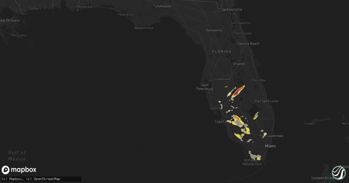
Hail Map in Florida on April 4, 2022
Get this storm
April 4 map
$229
one time, instant access
Download today. No call, no setup
Keep the $229
Bought the map and want the full workflow? Apply the entire $229 to a subscription within 7 days. None of it is wasted.
Every map, not just this one
This buys you this map. Subscription and you get every map we run, in the markets you choose from a few cities to whole states to nationwide. Plus real-time alerts the moment a storm fires.
Contact data
Name, contact info, occupancy, even credit band for addresses in the footprint. You go from where it hit to who to call.
Become the source they trust
Unlimited branding weather history reports on demand. You already have the documented answer ready for the property owner, and you are the one who showed up with it.
Property data and RoofTrace estimates
Pull up any address you have got, its value and the exact code rules for that jurisdiction, straight from One Click Code. Then RoofTrace estimates the squares, pitch, and roof value, priced the way you price.
Storm reports in Florida
Florida
| Date | Description |
|---|---|
| 04/04/20226:46 PM CDT | << late report >> time estimated by radar. Web cam caught a skinny rope tornado. Reports of power lines down in area. |
| 04/04/20225:53 PM CDT | Multiple golf ball size hail reports near avon park... Fl from trained spotters. |
| 04/04/20225:35 PM CDT | Multiple golf ball size hail reports near sebring... Fl from nws employee and trained spotters. |
| 04/04/20223:00 PM CDT | Emergency managers reported hail up to the size of quarters. Car reported dented from large hail along hwy 80 at the border of glades and hendry counties. |
| 04/04/20222:44 PM CDT | La belle fire station employee reported quarter size hail. |
| 04/04/20222:40 PM CDT | Emergency manager reported quarter to one-half dollar sized hail in the town of labelle. Time radar estimated. |
| 04/04/20222:40 PM CDT | Delayed report: broadcast media wink news fort myers... Relayed a report and photo of hail associated with a severe thunderstorm in labelle. The hail was estimated to b |
| 04/04/20222:43 AM CDT | At 742 PM EDT, a severe thunderstorm was located near Wauchula, moving northeast at 20 mph. HAZARD...60 mph wind gusts and quarter size hail. SOURCE...Radar indicated. IMPACT...Hail damage to vehicles is expected. Expect wind damage to roofs, siding, and trees. Locations impacted include... Avon Park and Avon Park Executive Airport. |
| 04/04/20222:34 AM CDT | At 733 PM EDT, a severe thunderstorm was located 10 miles southwest of Lake Marian, moving northeast at 25 mph. HAZARD...Ping pong ball size hail and 60 mph wind gusts. SOURCE...Radar indicated. IMPACT...People and animals outdoors will be injured. Expect hail damage to roofs, siding, windows, and vehicles. Expect wind damage to roofs, siding, and trees. Locations impacted include... Lake Kissimmee, Lake Marian, Kenansville and Forever Florida. |
| 04/04/20222:17 AM CDT | At 716 PM EDT, a severe thunderstorm was located 13 miles northeast of Avon Park, moving northeast at 30 mph. HAZARD...Golf ball size hail and 60 mph wind gusts. SOURCE...Trained weather spotters. IMPACT...People and animals outdoors will be injured. Expect hail damage to roofs, siding, windows, and vehicles. Expect wind damage to roofs, siding, and trees. Locations impacted include... River Ranch and Indian Lake Estates. |
| 04/04/20221:44 AM CDT | At 644 PM EDT, a severe thunderstorm was located near Sebring, moving northeast at 25 mph. HAZARD...60 mph wind gusts and half dollar size hail. SOURCE...Radar indicated. IMPACT...Hail damage to vehicles is expected. Expect wind damage to roofs, siding, and trees. Locations impacted include... Sebring, Avon Park, Avon Park Air Force Range, Sebring Shores and Avon Park Executive Airport. |
| 04/04/20221:21 AM CDT | At 620 PM EDT, a severe thunderstorm was located 9 miles west of Sebring, moving northeast at 25 mph. HAZARD...60 mph wind gusts and half dollar size hail. SOURCE...Radar indicated. IMPACT...Hail damage to vehicles is expected. Expect wind damage to roofs, siding, and trees. Locations impacted include... Sebring, Avon Park, Crewsville, Sebring Shores and Avon Park Executive Airport. |
| 04/04/202212:51 AM CDT | At 551 PM EDT, a severe thunderstorm was located near Big Cypress Seminole Reservation, or 27 miles east of Ave Maria, moving southeast at 10 mph. HAZARD...60 mph wind gusts and half dollar size hail. SOURCE...Radar indicated. IMPACT...Hail damage to vehicles is expected. Expect wind damage to roofs, siding, and trees. Locations impacted include... Hendry Correctional, Miccosukee Indian Reservation, Big Cypress Seminole Reservation, Miccosukee Service Plaza and Big Cypress National Preserve. |
| 04/04/202212:16 AM CDT | At 516 PM EDT, severe thunderstorms were located along a line extending from 8 miles west of Felda to 6 miles east of Immokalee to near Big Cypress Seminole Reservation, moving south at 15 mph. HAZARD...60 mph wind gusts and half dollar size hail. SOURCE...Radar indicated. IMPACT...Hail damage to vehicles is expected. Expect wind damage to roofs, siding, and trees. Locations impacted include... Ave Maria, Immokalee, Felda, Miccosukee Service Plaza and Hendry Correctional. |
| 04/03/202211:41 PM CDT | At 441 PM EDT, severe thunderstorms were located along a line extending from 7 miles northwest of Big Cypress Seminole Reservation to near Immokalee to Southwest Florida Airport, moving south at 5 mph. HAZARD...60 mph wind gusts and quarter size hail. SOURCE...Radar indicated. IMPACT...Hail damage to vehicles is possible. Wind damage to roofs, siding, and trees may also occur. Locations impacted include... Ave Maria, Immokalee, Hendry Correctional, Felda and Big Cypress Seminole Reservation. |
| 04/03/202211:24 PM CDT | At 423 PM EDT, a severe thunderstorm was located near Pa-Hay-Okee Overlook, or 18 miles northeast of Flamingo, moving southeast at 10 mph. HAZARD...60 mph wind gusts and quarter size hail. SOURCE...Radar indicated. IMPACT...Hail damage to vehicles is expected. Expect wind damage to roofs, siding, and trees. Locations impacted include... Mahogany Hammock, Pa-Hay- Okee Overlook, Royal Palm Ranger and Everglades National Park. |
| 04/03/202211:15 PM CDT | At 415 PM EDT, a severe thunderstorm was located near Copeland, or 12 miles north of Everglades City, moving southeast at 20 mph. HAZARD...60 mph wind gusts and half dollar size hail. SOURCE...Radar indicated. IMPACT...Hail damage to vehicles is possible. Wind damage to roofs, siding, and trees may also occur. Locations impacted include... Carnestown, Big Cypress National Preserve, Copeland, Miles City and Fakahatchee Strand State Preserve. |
| 04/03/202211:14 PM CDT | At 413 PM EDT, a severe thunderstorm was located 8 miles west of Devils Garden, or 11 miles west of Montura, moving southeast at 25 mph. HAZARD...60 mph wind gusts and quarter size hail. SOURCE...Radar indicated. IMPACT...Hail damage to vehicles is possible. Wind damage to roofs, siding, and trees may also occur. Locations impacted include... Montura, Immokalee, Hendry Correctional, Devils Garden and Keri. |
| 04/03/202210:47 PM CDT | At 347 PM EDT, a severe thunderstorm was located 9 miles southeast of Golden Gate Estates, moving east at 10 mph. HAZARD...60 mph wind gusts and half dollar size hail. SOURCE...Radar indicated. IMPACT...Hail damage to vehicles is possible. Wind damage to roofs, siding, and trees may also occur. Locations impacted include... Golden Gate Estates, Miles City, Fakahatchee Strand State Preserve, Picayune Strand State Forest and Deep Lake. |
| 04/03/202210:45 PM CDT | At 345 PM EDT, a severe thunderstorm was located near Labelle, moving southeast at 15 mph. HAZARD...60 mph wind gusts and half dollar size hail. SOURCE...Radar indicated. IMPACT...Hail damage to vehicles is possible. Wind damage to roofs, siding, and trees may also occur. Locations impacted include... Labelle, Montura, Port La Belle, Felda and Devils Garden. |
| 04/03/202210:40 PM CDT | At 339 PM EDT, severe thunderstorms were located along a line extending from near Big Cypress National Preserve to near Everglades National Park, moving east at 15 mph. HAZARD...60 mph wind gusts and quarter size hail. SOURCE...Radar indicated. IMPACT...Hail damage to vehicles is expected. Expect wind damage to roofs, siding, and trees. Locations impacted include... Shark Valley Obs Tower, Loop Road Ee Center, Everglades National Park, Big Cypress National Preserve and Dade-Collier Training Airport. |
| 04/03/202210:30 PM CDT | At 330 PM EDT, a severe thunderstorm was located near Fremd Village-Padgett Island, or near Pahokee, moving northeast at 20 mph. HAZARD...60 mph wind gusts and quarter size hail. SOURCE...Radar indicated. IMPACT...Hail damage to vehicles is expected. Expect wind damage to roofs, siding, and trees. Locations impacted include... Belle Glade, Pahokee, South Bay, Canal Point and Fremd Village-Padgett Island. |
| 04/03/202210:28 PM CDT | At 328 PM EDT, a severe thunderstorm was located over Labelle, moving northeast at 10 mph. HAZARD...60 mph wind gusts and half dollar size hail. SOURCE...Radar indicated. IMPACT...Hail damage to vehicles is expected. Expect wind damage to roofs, siding, and trees. Locations impacted include... Labelle, Palmdale, Port La Belle, Ortona and Muse. |
| 04/03/202210:14 PM CDT | At 314 PM EDT, a severe thunderstorm was located 11 miles south of Hendry Correctional, or 17 miles southeast of Ave Maria, moving east at 10 mph. HAZARD...60 mph wind gusts and half dollar size hail. SOURCE...Radar indicated. IMPACT...Hail damage to vehicles is expected. Expect wind damage to roofs, siding, and trees. Locations impacted include... Big Cypress National Preserve. |
| 04/03/202210:05 PM CDT | At 304 PM EDT, a severe thunderstorm was located over South Bay, moving east at 5 mph. HAZARD...60 mph wind gusts and quarter size hail. SOURCE...Radar indicated. IMPACT...Hail damage to vehicles is expected. Expect wind damage to roofs, siding, and trees. Locations impacted include... Belle Glade, Pahokee, South Bay, Lake Harbor and Canal Point. |
| 04/03/20229:58 PM CDT | At 257 PM EDT, severe thunderstorms were located along a line extending from Everglades National Park to near Royal Palm Ranger to 6 miles south of Florida City, and are nearly stationary. HAZARD...60 mph wind gusts and half dollar size hail. SOURCE...Radar indicated. IMPACT...Hail damage to vehicles is expected. Expect wind damage to roofs, siding, and trees. Locations impacted include... Homestead, Homestead General Airport, Homestead Miami Speedway, The Redland and Florida City. |
| 04/03/20229:28 PM CDT | At 228 PM EDT, a severe thunderstorm was located over Royal Palm Ranger, or 8 miles southwest of Homestead General Airport, and is nearly stationary. HAZARD...60 mph wind gusts and quarter size hail. SOURCE...Radar indicated. IMPACT...Hail damage to vehicles is expected. Expect wind damage to roofs, siding, and trees. Locations impacted include... Homestead, Florida City, Royal Palm Ranger and Everglades National Park. |
| 04/03/20229:12 PM CDT | At 211 PM EDT, a severe thunderstorm was located 10 miles southwest of Loxahatchee NWR, or 17 miles northwest of Coral Springs, moving north at 15 mph. HAZARD...60 mph wind gusts and quarter size hail. SOURCE...Radar indicated. IMPACT...Hail damage to vehicles is expected. Expect wind damage to roofs, siding, and trees. Locations impacted include... Loxahatchee NWR. |
| 04/03/20228:20 PM CDT | At 120 PM EDT, a severe thunderstorm was located near Sawgrass Mills Mall, or near Sunrise, moving northeast at 20 mph. HAZARD...Ping pong ball size hail and 60 mph wind gusts. SOURCE...Radar indicated. IMPACT...People and animals outdoors will be injured. Expect hail damage to roofs, siding, windows, and vehicles. Expect wind damage to roofs, siding, and trees. Locations impacted include... Coral Springs, Davie, Plantation, Sunrise and Deerfield Beach. |
| 04/03/20228:02 PM CDT | At 101 PM EDT, a severe thunderstorm was located over Weston, or 9 miles west of Sunrise, moving north at 15 mph. HAZARD...60 mph wind gusts and quarter size hail. SOURCE...Radar indicated. IMPACT...Hail damage to vehicles is expected. Expect wind damage to roofs, siding, and trees. Locations impacted include... Pembroke Pines, Coral Springs, Davie, Plantation and Sunrise. |
All States Impacted by Hail Map on April 4, 2022
Cities Impacted by Hail Map on April 4, 2022
- Ravenna, TX
- Bonham, TX
- Ivanhoe, TX
- Savoy, TX
- Telephone, TX
- Fletcher, OK
- Rush Springs, OK
- Bradley, OK
- Ninnekah, OK
- Wolfe City, TX
- Gordon, TX
- Stephenville, TX
- Mingus, TX
- Coppell, TX
- Irving, TX
- Dallas, TX
- Carrollton, TX
- Burleson, TX
- De Kalb, MS
- Preston, MS
- Avon Park, FL
- Sebring, FL
- Frostproof, FL
- Del Rio, TX
- Hayneville, AL
- Brandon, MS
- Sardis, AL
- Minter, AL
- Tyler, AL
- Evergreen, AL
- McKenzie, AL
- Fulton, AR
- Ennis, TX
- Waxahachie, TX
- Palmer, TX
- Flower Mound, TX
- Punta Gorda, FL
- Sylvester, TX
- McCaulley, TX
- Roby, TX
- Alva, FL
- Labelle, FL
- Immokalee, FL
- Fort Myers, FL
- Lehigh Acres, FL
- Clewiston, FL
- Quitman, MS
- Venus, TX
- Weatherford, TX
- Lillian, TX
- Alvarado, TX
- Fort Worth, TX
- Joshua, TX
- Cleburne, TX
- Mansfield, TX
- Crowley, TX
- Cresson, TX
- Godley, TX
- Flowood, MS
- Pelahatchie, MS
- Morton, MS
- Desdemona, TX
- Ranger, TX
- Dublin, TX
- Meridian, TX
- Clifton, TX
- Silver City, MS
- Collinsville, MS
- Texarkana, AR
- Emmet, AR
- Hope, AR
- Zolfo Springs, FL
- Lake Wales, FL
- River Ranch, FL
- Kenansville, FL
- Toxey, AL
- Butler, AL
- Grandview, TX
- Lewisville, TX
- Wanette, OK
- Yazoo City, MS
- Belzoni, MS
- Tchula, MS
- Newark, TX
- Honey Grove, TX
- Arcadia, FL
- Wayne, OK
- Maysville, OK
- Maypearl, TX
- Breckenridge, TX
- Caddo, TX
- Kilmichael, MS
- Sweet Water, AL
- Uniontown, AL
- Dixons Mills, AL
- Arlington, AL
- Safford, AL
- Linden, AL
- Pine Hill, AL
- Thomaston, AL
- Faunsdale, AL
- Pennington, AL
- Catherine, AL
- Alberta, AL
- Magnolia, AL
- Celeste, TX
- Leonard, TX
- Waurika, OK
- Ringling, OK
- Strawn, TX
- Palo Pinto, TX
- Lowndesboro, AL
- Selma, AL
- Justin, TX
- Paradise, TX
- Springtown, TX
- Boyd, TX
- Decatur, TX
- Ponder, TX
- Bridgeport, TX
- Rhome, TX
- Nocona, TX
- Saint Jo, TX
- Fort Lauderdale, FL
- Paducah, TX
- Lone Grove, OK
- Healdton, OK
- Wilson, OK
- Ardmore, OK
- Grapevine, TX
- Southlake, TX
- Seymour, TX
- Shubuta, MS
- Blue Ridge, TX
- Farmersville, TX
- Holliday, TX
- Olney, TX
- Albany, TX
- Eustace, TX
- Mabank, TX
- Clarksville, TX
- Idabel, OK
- Valliant, OK
- Garvin, OK
- Tolar, TX
- Bluff Dale, TX
- Lipan, TX
- Lawton, OK
- Faxon, OK
- Athens, TX
- Murchison, TX
- Malakoff, TX
- Larue, TX
- Brownsboro, TX
- Chandler, TX
- Elgin, OK
- Lena, MS
- Needham, AL
- Thomasville, AL
- Orrville, AL
- Gilbertown, AL
- Scurry, TX
- Kemp, TX
- Ferris, TX
- Granbury, TX
- Italy, TX
- Milford, TX
- Itasca, TX
- Sherman, TX
- Denison, TX
- Bells, TX
- Carthage, MS
- Kaufman, TX
- Rosser, TX
- Ochopee, FL
- Madison, MS
- Ridgeland, MS
- Jackson, MS
- Canton, MS
- Mangham, LA
- Monroe, LA
- Columbia, LA
- West Monroe, LA
- Rayville, LA
- Commerce, TX
- Graford, TX
- Duncan, OK
- Junction City, AR
- El Dorado, AR
- Mayersville, MS
- Sondheimer, LA
- Vicksburg, MS
- Tallulah, LA
- Lexington, MS
- Cruger, MS
- Weinert, TX
- Little Elm, TX
- Midlothian, TX
- Wauchula, FL
- Denton, TX
- Argyle, TX
- Poolville, TX
- Starkville, MS
- Lindsay, OK
- Purcell, OK
- Paoli, OK
- Knox City, TX
- Roanoke, TX
- Trinidad, TX
- Aubrey, TX
- Red Oak, TX
- Richton, MS
- Muenster, TX
- Krum, TX
- Sanger, TX
- Strong, AR
- Haynesville, LA
- Monroeville, AL
- Rolling Fork, MS
- Naples, FL
- Anson, TX
- Lexington, OK
- Marion Junction, AL
- Lisman, AL
- Newton, MS
- Sweetwater, TX
- Santo, TX
- Euless, TX
- Haslet, TX
- Lake Dallas, TX
- Keller, TX
- Bedford, TX
- Chico, TX
- Colleyville, TX
- The Colony, TX
- Addison, TX
- Hurst, TX
- Alvord, TX
- Richardson, TX
- North Richland Hills, TX
- Cary, MS
- Melissa, TX
- Anna, TX
- Blevins, AR
- Prescott, AR
- Myakka City, FL
- Florence, MS
- Forreston, TX
- Chatfield, TX
- Haltom City, TX
- Keene, TX
- Aledo, TX
- Arlington, TX
- Kennedale, TX
- Pachuta, MS
- Vossburg, MS
- Dodd City, TX
- Vaiden, MS
- Stewart, MS
- Ladonia, TX
- Klondike, TX
- Princeton, TX
- Pahokee, FL
- South Bay, FL
- Mckinney, TX
- Cumby, TX
- Sulphur Springs, TX
- Greenville, TX
- Van Alstyne, TX
- Venus, FL
- Auburn, AL
- Opelika, AL
- Bagwell, TX
- Stamford, TX
- Windom, TX
- Forest, MS
- Heidelberg, MS
- Frisco City, AL
- Peterman, AL
- Sturgis, MS
- Louisville, MS
- Miami, FL
- Port Charlotte, FL
- Rosston, AR
- Centerville, TX
- Ogden, AR
- Apache, OK
- Jayton, TX
- Moore Haven, FL
- Plano, TX
- Homestead, FL
- French Camp, MS
- Eupora, MS
- Newcastle, TX
- Coalgate, OK
- Stuart, OK
- Randlett, OK
- Scooba, MS
- Cement, OK
- Walnut Grove, MS
- Fort Meade, FL
- Spearsville, LA
- Bernice, LA
- Lillie, LA
- Richland, MS
- Pearl, MS
- Ryan, OK
- Montague, TX
- Bentonia, MS
- Broken Bow, OK
- Coushatta, LA
- Ringgold, LA
- Shreveport, LA
- Frierson, LA
- Keithville, LA
- Elm Grove, LA
- Downsville, LA
- Choudrant, LA
- Sterlington, LA
- Farmerville, LA
- Windthorst, TX
- Cooper, TX
- Lake Creek, TX
- Bogata, TX
- Annona, TX
- Avery, TX
- Rice, TX
- Ben Wheeler, TX
- Canton, TX
- Flint, TX
- Tyler, TX
- Henderson, TX
- Whitehouse, TX
- Troup, TX
- Overton, TX
- Arp, TX
- Carthage, TX
- Okeechobee, FL
- Belle Glade, FL
- Archer City, TX
- Perrin, TX
- Jacksboro, TX
- Petty, TX
- Gallion, AL
- Washington, AR
- Hazlehurst, MS
- Crystal Springs, MS


