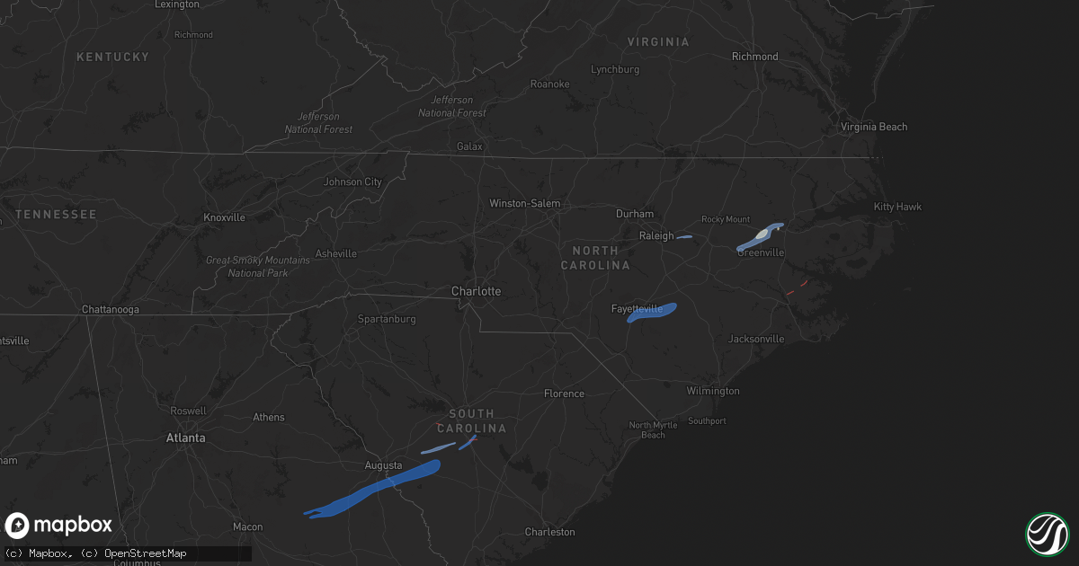
Hail Map in North Carolina on January 4, 2023
Get this storm
January 4 map
$229
one time, instant access
Download today. No call, no setup
Keep the $229
Bought the map and want the full workflow? Apply the entire $229 to a subscription within 7 days. None of it is wasted.
Every map, not just this one
This buys you this map. Subscription and you get every map we run, in the markets you choose from a few cities to whole states to nationwide. Plus real-time alerts the moment a storm fires.
Contact data
Name, contact info, occupancy, even credit band for addresses in the footprint. You go from where it hit to who to call.
Become the source they trust
Unlimited branding weather history reports on demand. You already have the documented answer ready for the property owner, and you are the one who showed up with it.
Property data and RoofTrace estimates
Pull up any address you have got, its value and the exact code rules for that jurisdiction, straight from One Click Code. Then RoofTrace estimates the squares, pitch, and roof value, priced the way you price.
Storm reports in North Carolina
North Carolina
| Date | Description |
|---|---|
| 01/04/20232:17 PM CST | 911 call center reported multiple trees down along the corner of nc 903 and hassell rd. |
| 01/04/20231:54 PM CST | Sheriffs dept called in to report multiple trees down along hwy 33 between broome rd and guilford station rd with some damage to nearby houses. Multiple power poles dow |
| 01/04/20231:49 PM CST | Law enforcement reported large pines twisted and broken with several powerlines down along bay view rd in bayview. |
| 01/04/20231:43 PM CST | Roof ripped of commercial building in the 1960 block of flat swamp rd. |
| 01/04/20231:43 PM CST | Corrects previous tstm wnd dmg report from gold point. 911 call center reported multiple trees down along the corner of nc 903 and hassell rd. |
| 01/04/20231:38 PM CST | Craven co. Emergency management reported trees down... One on a house... On morgan swamp rd. Northeast of new bern. |
| 01/04/20231:35 PM CST | Nws employee sent in photos of shingles blown off a roof... With a playground blown over and small branches down across residential lawn. Just nw of belvoir. |
| 01/04/20231:35 PM CST | Emergency manager reported multiple trees down with some damage to houses along territorial rd just ne of bridgeton. |
| 01/04/20231:27 PM CST | Pitt county 911 reported trees down on gum swamp church rd. And porter rd. Time based on radar. |
| 01/04/202312:45 PM CST | South lenoir high school gym sustained significant roof damage. |
| 01/04/202312:38 PM CST | Utility company reports multiple trees down on power lines causing power outages. |
| 01/04/202312:34 PM CST | Down tree reported near hwy 70a past country store road. |
| 01/04/202312:20 PM CST | Multiple trees down in the newton grove area. |
| 01/04/202312:18 PM CST | Large metal garage/warehouse structure lifted up and blown into road in the 1200 block of lanefield rd. Several trees down in the area as well. |
| 01/04/202312:15 PM CST | Corrects previous tstm wnd dmg report from 1 ne newton grove. Multiple trees down in the newton grove area. |
| 01/04/202312:13 PM CST | Downed tree reported near reedy prong church road and hwy 50. |
| 01/04/202312:10 PM CST | Skywarn passed along a report of an aluminum carport damaged. |
| 01/04/202311:34 AM CST | Asos station kfay fayetteville. |
| 01/04/202311:32 AM CST | Tree blown down onto the roof of a mobile home on hancock street. |
| 01/04/202311:21 AM CST | Firefighter reported a small building overturned... A porch blown off... And other damage off of parkton tobemory road near i-95 in the parkton area. Downed trees acros |
| 01/04/202310:21 AM CST | Firefighter reported a small building overturned... A porch blown off... And other damage off of parkton tobemory road near i-95 in the parkton area. Downed trees acros |
| 01/04/20236:40 AM CST | At 1239 PM EST, severe thunderstorms were located along a line extending from 6 miles northeast of Fayetteville to 14 miles northeast of Tobermory to near Jerome, moving northeast at 50 mph. HAZARD...60 mph wind gusts. SOURCE...Radar indicated. IMPACT...Expect damage to roofs, siding, and trees. Locations impacted include... Fayetteville, Clinton, Dunn, Benson, Godwin, Erwin, Eastover, Roseboro, Stedman and Newton Grove. |
| 01/03/20239:09 PM CST | At 307 PM EST, severe thunderstorms were located along a line extending from near Hinson to near Rose Bay to near South River, moving east at 60 mph. HAZARD...60 mph wind gusts. SOURCE...Radar indicated. IMPACT...Expect damage to roofs, siding, and trees. Locations impacted include... Plymouth, Stumpy Point, Cedar Island, South River, Belhaven, Killkenny, Manns Harbor, Swindell Fork, Alligator, Sladesville, Ponzer, Scranton, Merrimon, Gull Rock, Gum Neck, Kilkenny, Fairfield, Mashoes, Manteo and Pungo. |
| 01/03/20238:43 PM CST | At 243 PM EST, a severe thunderstorm was located near Williamston, moving northeast at 60 mph. HAZARD...60 mph wind gusts. SOURCE...Radar indicated. IMPACT...Expect damage to trees and powerlines. This severe thunderstorm will be near... Windsor around 255 PM EST. Valhalla, Cape Colony and Rockyhock around 315 PM EST. Hertford, Winfall and Snug Harbor around 325 PM EST.Other locations impacted by this severe thunderstorm include GoosePond, Whites Crossroads, Gliden, Newsome Store, Arrowhead Beach,Saint Johns, Republican, Mount Gould, Hancock and Yeopim Station. |
| 01/03/20238:38 PM CST | At 238 PM EST, a severe thunderstorm was located near Williamston, moving northeast at 70 mph. HAZARD...60 mph wind gusts. SOURCE...Radar indicated. IMPACT...Expect damage to roofs, siding, and trees. Locations impacted include... Williamston, Plymouth, Bethel, Stokes, Robersonville, Westover, Mackeys, Gold Point, Jamesville, Hamilton, Oak City, Parmele, Everetts, Dardens, Hassell and Beargrass. |
| 01/03/20238:31 PM CST | At 231 PM EST, severe thunderstorms were located along a line extending from Black Jack to near Cox Crossroads to Catfish Lake, moving east at 55 mph. HAZARD...60 mph wind gusts. SOURCE...Radar indicated. IMPACT...Expect damage to roofs, siding, and trees. Locations impacted include... Greenville, New Bern, Havelock, Washington, Plymouth, River Road, James City, Trent Woods, Belhaven, Swindell Fork, Sladesville, Ransomville, Ponzer, Scranton, Pinetown, Fairfield, Pungo, New Holland, Blounts Creek and Pamlico Beach. |
| 01/03/20238:02 PM CST | At 202 PM EST, severe thunderstorms were located along a line extending from 7 miles southwest of Halifax to 9 miles east of Fremont, moving northeast at 65 mph. HAZARD...60 mph wind gusts. SOURCE...Radar indicated. IMPACT...Expect damage to roofs, siding, and trees. Locations impacted include... Greenville, Winterville, Williamston, Farmville, Bethel, Stokes, Snow Hill, Bell Arthur, Robersonville, House, Bruce, Maury, Ormondsville, Roundtree, Lizzie, Pitt Greenville Airport, Dowdy Ficklen Stadium, East Carolina University, Gold Point and Fountain. |
| 01/03/20237:28 PM CST | At 128 PM EST, severe thunderstorms were located along a line extending from near Bunn to 7 miles southwest of Bailey to near Smithfield to 14 miles east of Benson, moving east at 40 mph. HAZARD...60 mph wind gusts. SOURCE...Radar indicated. IMPACT...Expect damage to roofs, siding, and trees. Locations impacted include... Rocky Mount, Goldsboro, Smithfield, Nashville, Wilson, Zebulon, Elm City, Fremont, Dortches and Walnut Creek. |
All States Impacted by Hail Map on January 4, 2023
Cities Impacted by Hail Map on January 4, 2023
- Gordon, AL
- Jakin, GA
- Yulee, FL
- Williamston, NC
- Quitman, GA
- Blountstown, FL
- Blakely, GA
- Saint George, GA
- Hilliard, FL
- Jacksonville, FL
- Woodbine, GA
- White Oak, GA
- Folkston, GA
- Malone, FL
- Marianna, FL
- Callahan, FL
- Bryceville, FL
- Bristol, FL
- Robersonville, NC
- Bethel, NC
- Saint Marys, GA
- Kings Bay, GA
- Sanderson, FL
- Altha, FL
- Clarksville, FL
- Stedman, NC
- Roseboro, NC
- Parkton, NC
- Clinton, NC
- Autryville, NC
- Fayetteville, NC
- Salemburg, NC
- Hope Mills, NC
- Zebulon, NC
- Wendell, NC
- Middlesex, NC
- Stokes, NC
- Fountain, NC
- Walstonburg, NC
- Farmville, NC
- Greenville, NC
- Jackson, SC
- Williston, SC
- Tennille, GA
- Bartow, GA
- Waynesboro, GA
- Windsor, SC
- Louisville, GA
- Sandersville, GA
- Aiken, SC
- New Ellenton, SC
- Stapleton, GA
- Augusta, GA
- Hephzibah, GA
- Wrens, GA
- Blythe, GA
- Springfield, SC
- Avera, GA
- Blackville, SC
- Keysville, GA
- Davisboro, GA
- Swansea, SC
- Wagener, SC
- Salley, SC
- North, SC
- Saint Matthews, SC
- Stockton, GA
- Millwood, GA
- Waycross, GA
- Axson, GA
- Nicholls, GA
- Colquitt, GA
- Lexington, SC
- New Bern, NC
- Aurora, NC
- Waverly, GA


