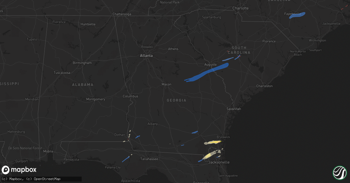
Hail Map in Georgia on January 4, 2023
Get this storm
January 4 map
$229
one time, instant access
Download today. No call, no setup
Keep the $229
Bought the map and want the full workflow? Apply the entire $229 to a subscription within 7 days. None of it is wasted.
Every map, not just this one
This buys you this map. Subscription and you get every map we run, in the markets you choose from a few cities to whole states to nationwide. Plus real-time alerts the moment a storm fires.
Contact data
Name, contact info, occupancy, even credit band for addresses in the footprint. You go from where it hit to who to call.
Become the source they trust
Unlimited branding weather history reports on demand. You already have the documented answer ready for the property owner, and you are the one who showed up with it.
Property data and RoofTrace estimates
Pull up any address you have got, its value and the exact code rules for that jurisdiction, straight from One Click Code. Then RoofTrace estimates the squares, pitch, and roof value, priced the way you price.
Storm reports in Georgia
Georgia
| Date | Description |
|---|---|
| 01/04/20231:13 PM CST | Tornado reported. Damage to sheds. |
| 01/04/20231:00 PM CST | Possible tornado reported near highway 17 northbound approaching woodbine. |
| 01/04/202312:41 PM CST | National weather service jacksonville storm survey determined that an ef-0 tornado... With an estimated peak wind speed of 80 mph... Briefly touched down along river ro |
| 01/04/202312:40 PM CST | Start point for northeast charlton county tornado 1/4/23 storm survey. |
| 01/04/202312:09 PM CST | Start point for bristol |
| 01/04/202311:49 AM CST | Trees down in dixie union. Time estimated by radar. |
| 01/04/202311:35 AM CST | Clinch county emergency management shared photos on social media of damaged trailers and sheds... Along with snapped pine trees... Along u.s. Highway 441 in clinch coun |
| 01/04/202310:29 AM CST | Tree down on old tusculum road at standard lane. |
| 01/04/20239:20 AM CST | One tree down at ga-3 and old cassidy rd. |
| 01/04/20239:15 AM CST | Tree limbs on sr-91 southbound at garrett rd. Blocking one lane. |
| 01/04/20239:10 AM CST | One tree down st springhill rd. And us-319. |
| 01/04/20238:46 AM CST | Numerous trees and power lines down on river road and highway 56. |
| 01/04/20238:45 AM CST | Numerous trees and power lines down in general area of old waynesboro road off highway 56. |
| 01/04/20238:40 AM CST | Numerous trees and power lines down in the vicinity of highway 25... Mcmanus road... Hillcrest drive and allen road. |
| 01/04/20238:35 AM CST | Public report of multiple trees down along winter avenue and personal weather station wind gust of 59 mph. Time estimated by radar. |
| 01/04/20238:32 AM CST | Tree down on boggs academy road. |
| 01/04/20238:25 AM CST | Columbia co ga em reported one tree down at county line rd and sawdust rd... Resulting in a total of 794 customers without power. Time estimated. |
| 01/04/20238:25 AM CST | One tree down near intersection of burl lane rd. And ed miller rd. Time estimated based off radar. |
| 01/04/20238:20 AM CST | One power pole down in donalsonville at west 2nd street and south wiley avenue. Time estimated based off radar. |
| 01/04/20238:17 AM CST | Minor damage was observed at the jefferson county middle and high schools... With moderate damage to the buildings around the softball field between the two schools. |
| 01/04/20238:13 AM CST | Trees and powerlines down at hwy 296 near jefferson county middle school. |
| 01/04/20238:12 AM CST | Trees down at hwy 296 and hwy88. |
| 01/04/20238:12 AM CST | Reports from em state extensivedamage at ostro steel on clarks mill rd with damage to 5 vehicles and several rollup doors dented or inoperable. |
| 01/04/20238:07 AM CST | Trees down along hwy171 approximately 4 miles east of hwy 540. |
| 01/04/20237:51 AM CST | *** 1 inj *** reported roof taken off house... House with tree on it... And 18-wheeler flipped. All along hwy 540 between deepstep rd and linton rd. |
| 01/04/20237:38 AM CST | Powerline down on jesse johnson ln. |
| 01/04/20237:38 AM CST | Downed powerline on s main street road. Location estimated. Time based on radar. |
| 01/04/20237:38 AM CST | Tree in powerline on cedar springs rd. Location estimated. |
| 01/04/20237:30 AM CST | Multiple trees down in north baldwin county to the north and northeast of milledgeville; including on/near greystone dr... Long acre rd... And watson reynolds rd. |
| 01/04/20236:51 AM CST | At 1251 PM EST, a severe thunderstorm was located near Jamestown, or 10 miles northwest of Blackshear, moving northeast at 40 mph. HAZARD...60 mph wind gusts and quarter size hail. SOURCE...Radar indicated. IMPACT...Hail damage to vehicles is expected. Expect wind damage to roofs, siding, and trees. Locations impacted include... Waycross, Blackshear, Patterson, Offerman, Boggy Bay, Jamestown, Pebble Hill, Bristol, Braganza and Fort Mudge. |
| 01/04/20236:46 AM CST | At 1245 PM EST, a severe thunderstorm was located 11 miles north of Fargo, moving northeast at 35 mph. HAZARD...60 mph wind gusts and quarter size hail. SOURCE...Radar indicated. IMPACT...Hail damage to vehicles is expected. Expect wind damage to roofs, siding, and trees. Locations impacted include... Stephen Foster State Park. |
| 01/04/20236:20 AM CST | Report of trees down near us 80 and pleasant hill church rd east of salem... Ga. |
| 01/04/20236:06 AM CST | At 1205 PM EST, a severe thunderstorm was located near Mayday, or 10 miles south of Lakeland, moving northeast at 55 mph. HAZARD...60 mph wind gusts. SOURCE...Radar indicated. IMPACT...Expect damage to roofs, siding, and trees. Locations impacted include... Naylor, Greenwood and Stockton. |
| 01/04/20235:42 AM CST | At 1142 AM EST, a severe thunderstorm was located near Lakeland, moving northeast at 45 mph. HAZARD...60 mph wind gusts and quarter size hail. SOURCE...Radar indicated. IMPACT...Hail damage to vehicles is expected. Expect wind damage to roofs, siding, and trees. Locations impacted include... Homerville, Pearson, Willacoochee, Du Pont, Cogdell and Axson. |
| 01/04/20235:01 AM CST | At 1100 AM EST, severe thunderstorms were located along a line extending from 7 miles west of Hahira to 8 miles northeast of Quitman to 13 miles southeast of Boston, moving east at 25 mph. HAZARD...60 mph wind gusts. SOURCE...Radar indicated. IMPACT...Expect damage to roofs, siding, and trees. Locations impacted include... Lake Park, Lakeland, Quitman, Valdosta, Adel, Hahira, Ray City, I-75 At Exit 16, Moody Air Force Base, Remerton, Meigs, Dasher, Morven, Cecil, Barretts, New Lois, Greggs, Hansell, Nankin and Empress. |
| 01/04/20234:31 AM CST | At 1031 AM EST, severe thunderstorms were located along a line extending from near Omega to 7 miles south of Monticello to near Carrabelle, moving northeast at 50 mph. HAZARD...60 mph wind gusts. SOURCE...Radar indicated. IMPACT...Expect damage to roofs, siding, and trees. Locations impacted include... Monticello, Perry, Steinhatchee, Madison, Greenville, Lee, Alma, Pinland, Jug Island, Pinetta, Drifton, Scanlon, Lovett, Foley, Hanson, Perry-Foley Airport, Hampton Springs, Iddo, Moseley Hall and Secotan. |
| 01/04/20234:20 AM CST | At 1020 AM EST, severe thunderstorms were located along a line extending from near Williston to near Sardis, moving east at 40 mph. HAZARD...60 mph wind gusts. SOURCE...Radar indicated. IMPACT...Expect damage to trees and powerlines. Locations impacted include: Allendale, Fairfax, Brunson, Gifford, Sycamore, Luray, Ulmer, Seigling, Martin, Barton, Millett, Appleton and Burtons Ferry Landing. |
| 01/04/20233:56 AM CST | At 956 AM EST, severe thunderstorms were located along a line extending from near Edgefield County Airport to near Jackson to near Perkins, moving east at 45 mph. HAZARD...60 mph wind gusts. SOURCE...Radar indicated. IMPACT...Expect damage to trees and powerlines. Locations impacted include... Aiken, Barnwell, Savannah River Site, Aiken Mall, Plant Vogtle, Williston, Blackville, New Ellenton, Jackson, Sardis, Alexander, USC Aiken, Aiken Municipal Airport, Citizens Park, Gloverville, Aiken State Park, Barnwell State Park, Graniteville, Burnettown and Wagener.This includes Interstate 20 in South Carolina between mile markers 11and 36. |
| 01/04/20233:50 AM CST | At 949 AM EST, severe thunderstorms were located along a line extending from 7 miles south of Bainbridge to 8 miles south of Greensboro to 20 miles east of Stonemill Creek to 11 miles east of Port St. Joe, moving northeast at 70 mph. HAZARD...60 mph wind gusts. SOURCE...Radar indicated. IMPACT...Expect damage to roofs, siding, and trees. Locations impacted include... Carrabelle, Tallahassee, St. Marks, Woodville, Crawfordville, St George Island, Florida State University, Tallahassee Comm College, Doak Campbell Stadium, Florida A And M, Wakulla, Sopchoppy, Lake Bradford, Cody, Jewel Fire Tower, Wakulla Springs, St George Island St Pk, Medart, Tallahassee Mall and Bloxham. |
| 01/04/20233:12 AM CST | At 912 AM EST, a severe thunderstorm was located over Stapletons Crossroads, or 9 miles northwest of Louisville, moving northeast at 55 mph. HAZARD...60 mph wind gusts. SOURCE...Radar indicated. IMPACT...Expect damage to roofs, siding, and trees. Locations impacted include... Louisville, Wrens, Davisboro, Stapleton, Avera, Matthews, Stellaville, Grange, Bastonville and Stapletons Crossroads. |
| 01/04/20232:49 AM CST | At 848 AM EST, a severe thunderstorm was located over Sandersville, moving east at 55 mph. HAZARD...60 mph wind gusts. SOURCE...Radar indicated. IMPACT...Expect damage to roofs, siding, and trees. Locations impacted include... Sandersville, Louisville, Gibson, Wrens, Davisboro, Tennille, Stapleton, Avera, Mitchell, Riddleville, Edge Hill, Edgehill, Downs, Warthen, Grange, Stapletons Crossroads and Agricola. |
| 01/04/20232:19 AM CST | At 819 AM EST/719 AM CST/, a severe thunderstorm was located near Chipley, moving northeast at 45 mph. HAZARD...60 mph wind gusts. SOURCE...Radar indicated. IMPACT...Expect damage to roofs, siding, and trees. Locations impacted include... Vernon, Chipley, Graceville, Bonifay, Blountstown, Marianna, Chattahoochee, Bradford, Malone, Sneads, Cottondale, Grand Ridge, Greenwood, Altha, Alford, Wausau, Esto, Ebro, Campbellton and Noma. |
| 01/04/20232:13 AM CST | At 812 AM EST, a severe thunderstorm was located over Tignall, or 8 miles north of Washington, moving northeast at 30 mph. HAZARD...60 mph wind gusts. SOURCE...Radar indicated. IMPACT...Expect damage to roofs, siding, and trees. Locations impacted include... Washington, Tignall, Jacksons Crossroads, Mallorysville, Newtown, Fishing Creek Public Hunting Area, Delhi, Norman, Danburg, Celeste, Metasville and Floral Hill. |
| 01/03/202311:37 PM CST | At 536 AM EST, severe thunderstorms were located along a line extending from near Campbellton to near Union City to near Fayetteville to near Haralson to near Greenville, moving northeast at 60 mph. HAZARD...60 mph wind gusts. SOURCE...Radar indicated. IMPACT...Expect damage to roofs, siding, and trees. Locations impacted include... Atlanta, Griffin, McDonough, Decatur, Fayetteville, Jonesboro, Zebulon, City of South Fulton, Peachtree City, East Point, Stockbridge, Union City, Forest Park, Riverdale, College Park, Fairburn, Clarkston, Hampton, Tyrone and Morrow. |
| 01/03/20239:57 PM CST | At 357 AM CST, a severe thunderstorm was located near Tuskegee National Forest, or 8 miles south of Auburn, moving east at 45 mph. HAZARD...60 mph wind gusts and penny size hail. SOURCE...Radar indicated. IMPACT...Expect damage to roofs, siding, and trees. Locations impacted include... Auburn, Phenix City, Opelika, Smiths, Smiths Station, Beulah, Beans Mill, Auburn University, Ladonia, Tuskegee National Forest, Beauregard, Society Hill, Bleecker, Griffen Mill, Robert G. Pitts Airport, Monterey Heights, Chewacla State Park, Ladonia Sports Complex, Marvyn and Phenix Drag Strip. |
| 01/03/20239:19 PM CST | At 319 AM CST, severe thunderstorms were located along a line extending from 6 miles northeast of Goldville to near Sparkling Springs to near Waverly, moving northeast at 65 mph. HAZARD...60 mph wind gusts. SOURCE...Radar indicated. IMPACT...Expect damage to roofs, siding, and trees. Locations impacted include... Valley, Lanett, Roanoke, Wedowee, Stroud, Lake Wedowee, Lafayette, La Fayette, Wadley, Woodland, Waverly, Lakeview, Five Points, Cusseta, Sturkie, Trammel Crossroads, Buffalo, Huguley, Fairfax and Crystal Lake. |
| 01/03/20239:15 PM CST | At 315 PM EST, a severe thunderstorm was located 9 miles northeast of Callahan, moving northeast at 40 mph. HAZARD...70 mph wind gusts and quarter size hail. Possible tornado. SOURCE...Radar indicated. IMPACT...Hail damage to vehicles is expected. Expect considerable tree damage. Wind damage is also likely to mobile homes, roofs, and outbuildings. Locations impacted include... St. Marys, Kingsland, Fernandina Beach, Jacksonville International Arpt, Kings Bay Base, Yulee, Cisco Gardens, Amelia City, Little Talbot Island and Jekyll Island. |
| 01/03/20239:11 PM CST | At 310 PM EST, a severe thunderstorm was located near Lake Butler, moving northeast at 50 mph. HAZARD...70 mph wind gusts and quarter size hail. Possible tornado. SOURCE...Radar indicated. IMPACT...Hail damage to vehicles is expected. Expect considerable tree damage. Wind damage is also likely to mobile homes, roofs, and outbuildings. Locations impacted include... Starke, Lake Butler, Callahan, Raiford, Middleburg, Macclenny, Glen St. Mary, Maxville, St. George and Beasley. |
| 01/03/20238:47 PM CST | At 247 PM EST, a severe thunderstorm was located near St. George, or 7 miles southwest of Hilliard, moving northeast at 50 mph. HAZARD...70 mph wind gusts and ping pong ball size hail. Possible tornado. SOURCE...Radar indicated. IMPACT...People and animals outdoors will be injured. Expect hail damage to roofs, siding, windows, and vehicles. Expect considerable tree damage. Wind damage is also likely to mobile homes, roofs, and outbuildings. Locations impacted include... Hilliard, Callahan and Kings Ferry. |
| 01/03/20238:28 PM CST | At 228 PM EST, a severe thunderstorm was located 8 miles southwest of Jekyll Island, or 10 miles southwest of Brunswick, moving east at 30 mph. HAZARD...Ping pong ball size hail and 60 mph wind gusts. SOURCE...Radar indicated. IMPACT...People and animals outdoors will be injured. Expect hail damage to roofs, siding, windows, and vehicles. Expect wind damage to roofs, siding, and trees. Locations impacted include... Jekyll Island, Dover Bluff and High Point. |
| 01/03/20237:18 PM CST | At 117 PM EST, severe thunderstorms were located along a line extending from near Screven to Hickox, moving northeast at 50 mph. HAZARD...60 mph wind gusts. SOURCE...Radar indicated. IMPACT...Expect damage to trees and powerlines. Locations impacted include: Hinesville, Darien, Ludowici, Tibet, Jones, McIntosh, Walthourville, Midway, Riceboro, Flemington, Allenhurst, Harris Neck, Eulonia, Valona and South Newport.This warning includes I-95 in Georgia between mile markers 50 and 84. |
All States Impacted by Hail Map on January 4, 2023
Cities Impacted by Hail Map on January 4, 2023
- Gordon, AL
- Jakin, GA
- Yulee, FL
- Williamston, NC
- Quitman, GA
- Blountstown, FL
- Blakely, GA
- Saint George, GA
- Hilliard, FL
- Jacksonville, FL
- Woodbine, GA
- White Oak, GA
- Folkston, GA
- Malone, FL
- Marianna, FL
- Callahan, FL
- Bryceville, FL
- Bristol, FL
- Robersonville, NC
- Bethel, NC
- Saint Marys, GA
- Kings Bay, GA
- Sanderson, FL
- Altha, FL
- Clarksville, FL
- Stedman, NC
- Roseboro, NC
- Parkton, NC
- Clinton, NC
- Autryville, NC
- Fayetteville, NC
- Salemburg, NC
- Hope Mills, NC
- Zebulon, NC
- Wendell, NC
- Middlesex, NC
- Stokes, NC
- Fountain, NC
- Walstonburg, NC
- Farmville, NC
- Greenville, NC
- Jackson, SC
- Williston, SC
- Tennille, GA
- Bartow, GA
- Waynesboro, GA
- Windsor, SC
- Louisville, GA
- Sandersville, GA
- Aiken, SC
- New Ellenton, SC
- Stapleton, GA
- Augusta, GA
- Hephzibah, GA
- Wrens, GA
- Blythe, GA
- Springfield, SC
- Avera, GA
- Blackville, SC
- Keysville, GA
- Davisboro, GA
- Swansea, SC
- Wagener, SC
- Salley, SC
- North, SC
- Saint Matthews, SC
- Stockton, GA
- Millwood, GA
- Waycross, GA
- Axson, GA
- Nicholls, GA
- Colquitt, GA
- Lexington, SC
- New Bern, NC
- Aurora, NC
- Waverly, GA


