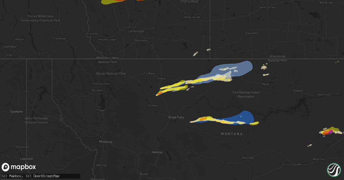
Hail Map on August 20, 2025
Get this storm
August 20 map
$229
one time, instant access
Download today. No call, no setup
Keep the $229
Bought the map and want the full workflow? Apply the entire $229 to a subscription within 7 days. None of it is wasted.
Every map, not just this one
This buys you this map. Subscription and you get every map we run, in the markets you choose from a few cities to whole states to nationwide. Plus real-time alerts the moment a storm fires.
Contact data
Name, contact info, occupancy, even credit band for addresses in the footprint. You go from where it hit to who to call.
Become the source they trust
Unlimited branding weather history reports on demand. You already have the documented answer ready for the property owner, and you are the one who showed up with it.
Property data and RoofTrace estimates
Pull up any address you have got, its value and the exact code rules for that jurisdiction, straight from One Click Code. Then RoofTrace estimates the squares, pitch, and roof value, priced the way you price.
States Impacted by Hail Map on August 20, 2025
Storm reports
Alabama
| Date | Description |
|---|---|
| 08/20/20255:50 PM CDT | A large tree limb was knocked down blocking all lanes of the roadway at 2251 cr 22. Time estimated by radar. |
| 08/20/20255:50 PM CDT | Tree down blocking almost the whole road on county rd 23. |
| 08/20/20255:50 PM CDT | Two large bamboo trees were knocked down into the roadway blocking one lane at the intersection of cr 25 and cr 144. Time estimated by radar. |
| 08/20/20255:48 PM CDT | A tree was knocked down and blocking both lanes at the intersection of cr 14 and cr 19. Time estimated by radar. |
| 08/20/20255:32 PM CDT | A tree was knocked down blocking both lanes of the road at the intersection of cr 7 and cr 6 at shadowbrook drive. Time estimated by radar. |
| 08/20/20255:25 PM CDT | Power line down along county rd 382 south of centre. |
| 08/20/20255:20 PM CDT | A tree and power lines were knocked down onto the roadway at the intersection of cr 7 and cr 639. Time estimated by radar. |
| 08/20/20255:15 PM CDT | A tree fell on a house located along valley acres rd in leesburg. |
| 08/20/20255:12 PM CDT | Tree down across county rd 36 three miles west of state highway 68. |
| 08/20/20255:10 PM CDT | Tree down blocking county rd 50 near sand rock. |
| 08/20/20255:03 PM CDT | Tree down blocking state highway 273. |
| 08/20/20255:03 PM CDT | Tree down blocking county rd 91. |
| 08/20/20255:02 PM CDT | Tree down blocking the roadway at railroad ave and cornwall dr in cedar bluff. |
| 08/20/20255:00 PM CDT | Tree down blocking county rd 133 between blanche and broomtown. |
| 08/20/20254:56 PM CDT | A tree was knocked down at the intersection of alabama highway 68 and cr 57. Time estimated by radar. |
| 08/20/20254:55 PM CDT | Tree down blocking county rd 15 at henderson hill cemetery. |
| 08/20/20254:55 PM CDT | Tree down blocking county rd 15 at hen |
| 08/20/20254:43 PM CDT | Power lines were knocked down at 3400 cr 97 in pine ridge. Time estimated by radar. |
| 08/20/20254:40 PM CDT | A tree was knocked down blocking one lane of traffic at 3500 cr 156 which is 1 mile west of cr 155. Time estimated by radar. |
| 08/20/20254:38 PM CDT | A tree was knocked down blocking both lanes of the road at 572 cr 531. Time estimated by radar. |
| 08/20/20254:35 PM CDT | A tree was knocked down at 2700 cr 494. Time estimated by radar. |
| 08/20/20254:31 PM CDT | A tree was knocked down blocking one lane of i-59 at mm 226. Time estimated by radar. |
| 08/20/20254:31 PM CDT | A tree was knocked down at 6600 cr 121. Time estimated by radar. |
| 08/20/20254:29 PM CDT | A tree and power line were knocked down at 300 george wallace drive. Time estimated by radar. |
| 08/20/20254:23 PM CDT | A tree and power lines were knocked down at 464 lowery road. Time estimated by radar. |
| 08/20/20254:21 PM CDT | Multiple trees were knocked down on i-59 close to the hammondville exit. Time estimated by radar. |
| 08/20/20254:20 PM CDT | Trees and power lines were knocked down at 464 lowery road. Time estimated by radar. |
| 08/20/20254:08 PM CDT | A tree was knocked down blocking the roaday on highway 117 in bass. Time estimated by radar. |
| 08/20/20252:20 PM CDT | A tree was knocked down at 990 discovery drive. Time estimated by nearby mesonet site. |
| 08/20/20252:10 PM CDT | A tree was knocked down at oakwood road and bethany lane. |
| 08/20/20251:24 PM CDT | A tree was knocked down at 2502 rochell drive nw. Time estimated by radar. |
| 08/19/20257:12 PM CDT | A tree was knocked down blocking both lanes of the roadway at the intersection of cr 54 and cr 14. Time estimated by radar. |
Idaho
| Date | Description |
|---|---|
| 08/20/202510:00 AM CDT | Two large carports destroyed and blown in to a wooden fence... Knocking the fence down. Also... A trampoline lofted landing on a utility trailer in the side of a reside |
Tennessee
| Date | Description |
|---|---|
| 08/20/20253:45 PM CDT | Multiple trees down near the bolo club. |
| 08/20/20253:03 PM CDT | Multiple trees were knocked down at 7000 highway 50 in decherd. Time estimated by radar. |
| 08/20/20253:00 PM CDT | Power lines down due to falleing tree limbs and branches. Lightning caused a house fire. |
| 08/20/20253:00 PM CDT | Pow |
| 08/20/20251:45 PM CDT | Multiple trees were knocked down in capitol hill. Time estimated by radar. |
Louisiana
| Date | Description |
|---|---|
| 08/20/20255:18 PM CDT | Report of a tree that fell on a house. |
| 08/20/20255:06 PM CDT | Tree down on wafer rd. |
| 08/20/20254:47 PM CDT | Small trees snapped on east blvd in baton rouge relayed by broadcast media. Time estimated by radar. |
| 08/20/20254:45 PM CDT | Reports of multiple trees down in doyline la. |
| 08/20/20254:35 PM CDT | Reports of a powerline down in dixie inn. |
| 08/20/20254:21 PM CDT | Tree down on fairview pt. |
Montana
| Date | Description |
|---|---|
| 08/20/20256:55 PM CDT | Corrects previous non-tstm wnd gst report from 8 ene denton. Awos station k1dm 7 ene denton. |
| 08/20/20256:54 PM CDT | Peak wind gust measured by ambient station pg ranch. |
| 08/20/20256:38 PM CDT | Social media picture of hail approximated to be 1.25 inches or a bit larger 1 mile south of havre. Time estimated using radar. |
| 08/20/20256:35 PM CDT | A local report indicates 75 MPH wind near 4 W Havre |
| 08/20/20256:30 PM CDT | A local report indicates 63 MPH wind near 7 SW Havre |
| 08/20/20256:29 PM CDT | A local report indicates 58 MPH wind near 4 W Havre |
| 08/20/20255:30 PM CDT | Mesonet station gw4079 inverness ten south southeas. |
| 08/20/20254:25 PM CDT | Bootlegger s cg sw mesonet. |
| 08/20/20255:32 AM CDT | Awos station kgdv glendive airport. |
| 08/20/20254:53 AM CDT | Winds knocked down tree limbs. It is estimated that gusts of 50 to 60 mph occurred. |
| 08/20/20254:53 AM CDT | Wind also accompanied the storm... Knocking tree limbs down. |
| 08/19/20258:20 PM CDT | Montana mesonet station roy e. Sustained winds of 44 mph at time of report. |
| 08/19/20258:20 PM CDT | Montana mesonet station |
Arizona
| Date | Description |
|---|---|
| 08/19/20258:55 PM CDT | Awos station ka |
| 08/19/20258:55 PM CDT | Awos station kavq marana regional airport. |
Georgia
| Date | Description |
|---|---|
| 08/19/20257:40 PM CDT | Social media photo showed large tree blown down into the roadway on greenbriar pkwy sw. |
Florida
| Date | Description |
|---|---|
| 08/20/20254:18 PM CDT | Fl dot camera showed tree down on i-10 impeding traffic. |
Mississippi
| Date | Description |
|---|---|
| 08/20/20255:08 PM CDT | A couple of trees down in the nw part of the county. |
| 08/20/20254:33 PM CDT | A few trees down on dixon rd. |
| 08/20/20254:16 PM CDT | Trees and power lines down on forest grove road. Road crew in in route to clear the road. |
| 08/20/20253:33 PM CDT | Some trees down along highway 18 from near the hinds co line to the community of carpenter. |
| 08/20/20253:12 PM CDT | Tree down blocking learned rd near pardue rd. Another tree down blocking neil collins rd near seaton rd. |
| 08/20/20252:40 PM CDT | A few trees down along hwy 43s & 14w. |
| 08/20/20252:02 PM CDT | Roof partially blown off of inmate house |
| 08/20/202512:50 PM CDT | Two trees down blocking highway 43... Near highway 17. |
| 08/20/202512:43 PM CDT | A couple trees down just on the leake co side. |
Cities Impacted by Hail Map on August 20, 2025
- Camden, MS
- Kosciusko, MS
- Canton, MS
- Dayton, TN
- Carthage, TX
- Crossville, TN
- Altha, FL
- Marianna, FL
- Grandview, TN
- Ethel, MS
- Huntsville, AL
- Mertzon, TX
- Harriman, TN
- Garrison, TX
- Nacogdoches, TX
- Morrison, TN
- Mcminnville, TN
- Georgetown, TN
- Birchwood, TN
- Harrison, TN
- Old Fort, NC
- Ringgold, LA
- West Point, MS
- Cleveland, TN
- Signal Mountain, TN
- Hamilton, MS
- Prairie, MS
- Utica, MS
- Raymond, MS
- Fort Rucker, AL
- Ozark, AL
- Duck Hill, MS
- Grenada, MS
- Berry, AL
- Northport, AL
- Aberdeen, MS
- Belvidere, TN
- Winchester, TN
- Pickens, SC
- Conrad, MT
- Detroit, AL
- Sulligent, AL
- Greenwood Springs, MS
- Ledger, MT
- Quincy, FL
- Attapulgus, GA
- Greenwood, MS
- Havana, FL
- Elm Grove, LA
- Sherwood, TN
- Choteau, MT
- El Dorado, AR
- Gattman, MS
- Caledonia, MS
- Galata, MT
- Chester, MT
- Vaiden, MS
- Hazlehurst, MS
- Grand Cane, LA
- Frierson, LA
- Imperial, TX
- Gloster, LA
- Union Church, MS
- Eldorado, TX
- Livingston, TX
- Cleveland, TX
- Hermitage, AR
- Highland Home, AL
- Luverne, AL
- Honoraville, AL
- Leesburg, AL
- Warren, AR
- Joplin, MT
- Jamestown, TN
- Allardt, TN
- Spring Hill, TN
- Columbia, TN
- Inverness, MT
- Cedar Bluff, AL
- Rudyard, MT
- Hingham, MT
- Paoli, OK
- Muscle Shoals, AL
- Gildford, MT
- Rayville, LA
- Tuscumbia, AL
- Maysville, OK
- Belt, MT
- Pauls Valley, OK
- Geyser, MT
- Hayneville, AL
- Lowndesboro, AL
- Kremlin, MT
- Box Elder, MT
- Baskin, LA
- Highwood, MT
- Raynesford, MT
- Rattan, OK
- Havre, MT
- Geraldine, MT
- Coffee Creek, MT
- Georgetown, LA
- Hugo, OK
- Jacksonville, AL
- Wellington, AL
- Alexandria, AL
- Denton, MT
- Winnsboro, LA
- Monticello, AR
- Anniston, AL
- Lineville, AL
- Chinook, MT
- Soper, OK
- Jones, LA
- Lewistown, MT
- Hilger, MT
- Marion, AL
- Bonita, LA
- Atlanta, GA
- Mer Rouge, LA
- Harlem, MT
- Zurich, MT
- Hogeland, MT
- Roy, MT
- Winifred, MT
- Turner, MT
- Hampton, GA
- Fayetteville, GA
- Malta, MT
- Winnett, MT
- Marana, AZ
- Tucson, AZ
- Loring, MT
- Terry, MT
- Lindsay, MT
- Circle, MT
- Brockway, MT
- Angela, MT
- Glendive, MT
- Whitetail, MT