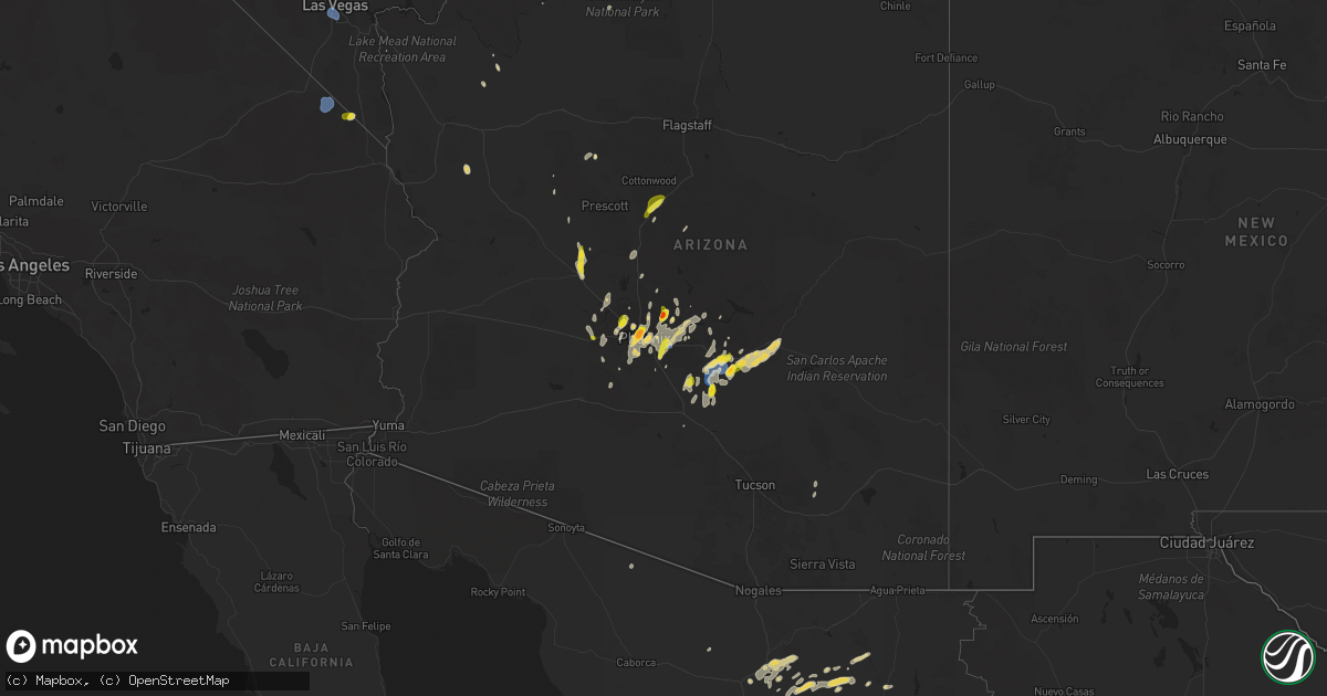
Hail Map on September 26, 2025
Get this storm
September 26 map
$229
one time, instant access
Download today. No call, no setup
Keep the $229
Bought the map and want the full workflow? Apply the entire $229 to a subscription within 7 days. None of it is wasted.
Every map, not just this one
This buys you this map. Subscription and you get every map we run, in the markets you choose from a few cities to whole states to nationwide. Plus real-time alerts the moment a storm fires.
Contact data
Name, contact info, occupancy, even credit band for addresses in the footprint. You go from where it hit to who to call.
Become the source they trust
Unlimited branding weather history reports on demand. You already have the documented answer ready for the property owner, and you are the one who showed up with it.
Property data and RoofTrace estimates
Pull up any address you have got, its value and the exact code rules for that jurisdiction, straight from One Click Code. Then RoofTrace estimates the squares, pitch, and roof value, priced the way you price.
States Impacted by Hail Map on September 26, 2025
Storm reports
Nevada
| Date | Description |
|---|---|
| 09/26/20255:45 PM CDT | Large tree down from thunderstorm related wind gusts at angel park golf club. |
| 09/26/20255:35 PM CDT | Gust of 62 mph measured on the south end of the las vegas strip from a nearby thunderstorm. Data courtesy of earth networks. |
| 09/26/20255:35 PM CDT | Gust of 60 mph measured on the north end of the las vegas strip from a nearby thunderstorm. Data courtesy of earth networks. |
| 09/26/20255:31 PM CDT | Harry reid international airport asos measured a gust of 65 mph from a nearby thunderstorm. |
| 09/26/20258:00 AM CDT | A local report indicates 67 MPH wind near 32 N Mercury |
South Carolina
| Date | Description |
|---|---|
| 09/26/20253:16 PM CDT | Scdps reported power lines in the road near monticello rd. |
Utah
| Date | Description |
|---|---|
| 09/26/20255:52 PM CDT | Mesonet station badu1 badger spring. |
| 09/26/20254:20 PM CDT | Mesonet station pc479 jackson spring. |
Arizona
| Date | Description |
|---|---|
| 09/26/20252:37 PM CDT | Powerlines down in the area of chandler heights rd. To komatke rd. And hays rd. To 189th ave. |
| 09/26/20252:00 PM CDT | A local report indicates 1.00 inch wind near 2 WNW Chandler |
| 09/26/20251:39 PM CDT | Delayed report. Minor wind damage. A few broken windows. Report of a gustnado on the leading edge of the storm. |
| 09/26/20251:27 PM CDT | 1.25 inch hail was reported. |
| 09/26/20251:21 PM CDT | Powerlines down in the block between thomas road and mcdowell road and 43rd avenue and 39th avenue. |
| 09/26/20251:20 PM CDT | Powerline down near the area of claremont street and 55th avenue in glendale. |
| 09/26/20251:20 PM CDT | Report of 1 inch hail at intersection of thompson peak and paradise lane. Extremely heavy rainfall with flooded parking lots. |
| 09/26/20251:19 PM CDT | 2 inch hail was reported. |
| 09/26/20251:15 PM CDT | 1-1.25 inch hail reported. |
| 09/26/20251:09 PM CDT | Report of golf-ball sized hail leading to dented cars on bell rd. |
| 09/26/20251:07 PM CDT | A local report indicates 1.00 inch wind near 5 N Phoenix |
| 09/26/20251:05 PM CDT | 1 inch hail was reported. |
| 09/26/20251:05 PM CDT | Photo of quarter-sized hail near downtown phoenix. Location approximated based on radar. |
| 09/26/202512:22 PM CDT | Photo of estimated quarter-sized hail in sun lakes. Location approximated based on radar. |
| 09/26/202512:20 PM CDT | 1 inch hail was reported. |
| 09/26/20257:05 AM CDT | 1 inch hail estimated. Report from facebook post. |
California
| Date | Description |
|---|---|
| 09/26/20255:53 PM CDT | Gust of 59 mph measured at mesonet site up165. |
Cities Impacted by Hail Map on September 26, 2025
- Mayer, AZ
- Camp Verde, AZ
- Wickenburg, AZ
- Morristown, AZ
- Surprise, AZ
- Wittmann, AZ
- Congress, AZ
- Litchfield Park, AZ
- Glendale, AZ
- Avondale, AZ
- Phoenix, AZ
- Goodyear, AZ
- Laveen, AZ
- Peoria, AZ
- Sun City, AZ
- Youngtown, AZ
- Coolidge, AZ
- Casa Grande, AZ
- El Mirage, AZ
- Kirkland, AZ
- New River, AZ
- Scottsdale, AZ
- Black Canyon City, AZ
- Paulden, AZ
- Mesa, AZ
- North Rim, AZ
- Florence, AZ
- Chandler, AZ
- Superior, AZ
- Fort Mcdowell, AZ
- Prescott, AZ
- Fountain Hills, AZ
- Tempe, AZ
- Cave Creek, AZ
- Gilbert, AZ
- Paradise Valley, AZ
- Gold Canyon, AZ
- San Tan Valley, AZ
- Irmo, SC
- Columbia, SC
- Blythewood, SC
- Buckeye, AZ
- Denton, NC
- Winnsboro, SC
- Armstrong, TX
- Clarkton, NC
- Queen Creek, AZ
- Kearny, AZ
- Yucca, AZ
- Miami, AZ
- Hallock, MN
- Lake Bronson, MN
- Lancaster, MN
- Globe, AZ
- Las Vegas, NV
- Henderson, NV
- Nipton, CA
- Cashion, AZ
- Five Points, AL