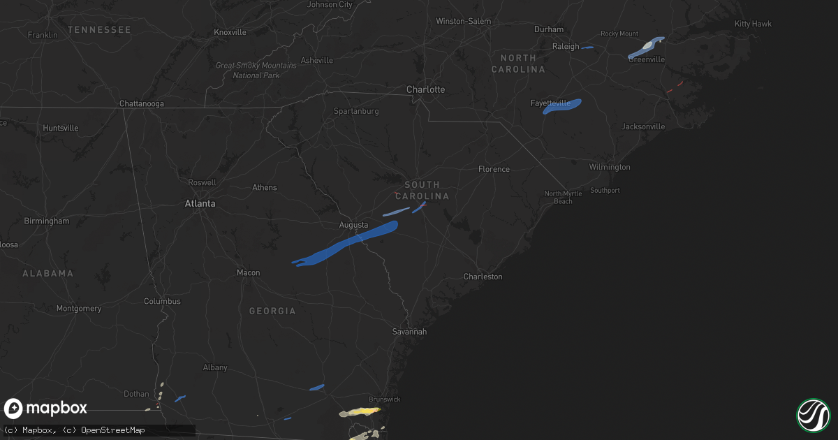
Hail Map in South Carolina on January 4, 2023
Get this storm
January 4 map
$229
one time, instant access
Download today. No call, no setup
Keep the $229
Bought the map and want the full workflow? Apply the entire $229 to a subscription within 7 days. None of it is wasted.
Every map, not just this one
This buys you this map. Subscription and you get every map we run, in the markets you choose from a few cities to whole states to nationwide. Plus real-time alerts the moment a storm fires.
Contact data
Name, contact info, occupancy, even credit band for addresses in the footprint. You go from where it hit to who to call.
Become the source they trust
Unlimited branding weather history reports on demand. You already have the documented answer ready for the property owner, and you are the one who showed up with it.
Property data and RoofTrace estimates
Pull up any address you have got, its value and the exact code rules for that jurisdiction, straight from One Click Code. Then RoofTrace estimates the squares, pitch, and roof value, priced the way you price.
Storm reports in South Carolina
South Carolina
| Date | Description |
|---|---|
| 01/04/202312:20 PM CST | Few trees uprooted/snapped and power lines down near the intersection of juniper bay rd and johnson shortcut rd. |
| 01/04/202311:11 AM CST | A tree down along with powerlines was reported in the 1400 block of peirce road. |
| 01/04/202310:00 AM CST | Sc highway patrol reported trees in roadway at mcmillan and cannon bridge road. Time estimated by radar. |
| 01/04/20239:50 AM CST | Possible tornado. |
| 01/04/20239:50 AM CST | Public report of numerous structures damaged in blue ridge terrace. Tornado possible. Time estimated by radar. |
| 01/04/20239:50 AM CST | Incorrect location and after further investigation no damage was found at this location. Damage was found nearby on gator road. Corrects previous tstm wnd dmg report fr |
| 01/04/20239:50 AM CST | Corrects previous tstm wnd dmg report from 1 wsw south congaree. Incorrect location and will be investigated further. Public report of numerous structures damaged in bl |
| 01/04/20239:48 AM CST | Trees down and damage to a carport in the 1400 block of woodford road. Possible tornado damage. |
| 01/04/20239:45 AM CST | Lexington pd reported tree down on powerline on liberty hill road. Tornado possible. Time estimated. |
| 01/04/20239:45 AM CST | Lexington pd reported trees and power line down along calks ferry road. Tornadoes possible. Time estimated. |
| 01/04/20239:45 AM CST | Public report of tree damage and missing garbage cans on old orangeburg rd between platt springs rd and 302. Possible tornado. Time estimated from radar. |
| 01/04/20239:44 AM CST | A national weather service survey team confirmed an ef-0 tornado with peak winds of 75 mph that tracked across central lexington county... North of shuler. The tornado |
| 01/04/20239:43 AM CST | Multiple trees down near the intersection of highway 178 and pools mill road. Possible tornado. Time estimated from radar. |
| 01/04/20239:33 AM CST | Mobile home blown off of foundation on nick street... Trapping a women. No reported injuries. A tin roof was also damaged at a day care in this same general vicinity. |
| 01/04/20239:33 AM CST | Corrects previous tstm wnd dmg report from 1 ne blackville. Mobile home blown off of foundation on nick street... Trapping a women. No reported injuries. About 30 or mo |
| 01/04/20239:33 AM CST | Building collapse and power lines down in sally on depot ave ne. |
| 01/04/20239:28 AM CST | Aiken county em reports damage to property on springflower rd near wagener rd. Possible tornado. |
| 01/04/20239:16 AM CST | Couchton fire district reports outbuilding destroyed on farmer rd and hwy 302. |
| 01/04/20238:55 AM CST | Trees and power lines down in jackson... Sc. |
| 01/04/20238:20 AM CST | Trees and branches. |
| 01/04/20238:17 AM CST | Trees and branches. |
| 01/04/20238:15 AM CST | Trees and branches down. |
| 01/04/20238:15 AM CST | Trees and branches down. |
| 01/04/20238:10 AM CST | Trees and branches. |
| 01/04/20238:10 AM CST | Trees and branches. |
| 01/04/20238:10 AM CST | Trees and branches down. |
| 01/04/20238:07 AM CST | Trees and branches. Time estimated from radar. |
| 01/04/20238:05 AM CST | Trees and branches down. |
| 01/04/20238:00 AM CST | Trees and branches down. |
| 01/04/20237:50 AM CST | Mccormick co sc em reported a tree down across the road on hwy 81 near willington... Exact location not provided. Time estimated. |
| 01/04/20235:34 AM CST | At 1133 AM EST, a severe thunderstorm was located over Reevesville, moving east at 40 mph. HAZARD...60 mph wind gusts. SOURCE...Radar indicated. IMPACT...Expect damage to trees and powerlines. Locations impacted include: Saint George, Dorchester, Colleton, Harleyville, Reevesville, Smoaks, Lodge, Williams, Ruffin, Ashton, Canadys, Islandton and Padgetts.This warning includes the following interstates: I-26 between mile markers 171 and 188. I-95 in South Carolina between mile markers 60 and 85. |
| 01/04/20235:19 AM CST | At 1119 AM EST, a severe thunderstorm was located over Kildare, moving east at 45 mph. HAZARD...60 mph wind gusts. SOURCE...Radar indicated. IMPACT...Expect damage to trees and powerlines. Locations impacted include: Newington, Garnett, Egypt, Shawnee, Pineland, Tarboro, Robertville, Clyo and Kildare. |
| 01/04/20235:17 AM CST | At 1116 AM EST, severe thunderstorms were located along a line extending from 8 miles northeast of McEntire Air Base to 6 miles north of Bowman to near Branchville, moving east at 45 mph. HAZARD...60 mph wind gusts. SOURCE...Radar indicated. Wind damage has been reported with these storms! IMPACT...Expect damage to trees and powerlines. Locations impacted include... Columbia, Sumter, Manning, South Sumter, Shaw Air Base, St. Matthews, Holly Hill, Summerton, Bowman, Eastover, Elloree, Oakland, Santee State Park, Mulberry, Alcolu, Woods Bay State Park, Santee Cooper Regional Airport, Elliott, Sumter County Airport and Gadsden.This includes the following highways... Interstate 26 between mile markers 151 and 169. Interstate 95 between mile markers 85 and 146. |
| 01/04/20235:08 AM CST | At 1108 AM EST, a severe thunderstorm was located over Gifford, moving east at 45 mph. HAZARD...60 mph wind gusts. SOURCE...Radar indicated. IMPACT...Expect damage to trees and powerlines. Locations impacted include: Hampton, Lake Warren State Park, Varnville, Brunson, Gifford, Luray, Crocketville, Miley and Almeda Intersection. |
| 01/04/20234:35 AM CST | At 1034 AM EST, severe thunderstorms were located along a line extending from 9 miles south of Red Bank to near Blackville to near Martin, moving east at 45 mph. HAZARD...70 mph wind gusts. SOURCE...Radar indicated. This storm has a history of producing wind damage. IMPACT...Expect considerable tree damage. Damage is likely to mobile homes, roofs, and outbuildings. Locations impacted include... Orangeburg, Barnwell, Bamberg, Denmark, McEntire Air Base, Brookdale, Blackville, St. Matthews, Gaston, Branchville, Bowman, Eastover, Orangeburg County Airport, Barnwell State Park, Congaree National Park, Hopkins, Claflin College, South Carolina State University, Sandy Run and Gadsden.This includes Interstate 26 between mile markers 118 and 162. |
| 01/04/20234:16 AM CST | At 1016 AM EST, severe thunderstorms were located along a line extending from 9 miles west of Dreher Island State Park to Batesburg-Leesville to 8 miles northeast of Ridge Spring to 10 miles northeast of Aiken Municipal Airport, moving northeast at 65 mph. HAZARD...60 mph wind gusts. SOURCE...Radar indicated. IMPACT...Expect damage to trees and powerlines. Locations impacted include... Columbia, Lexington, West Columbia, Cayce, Irmo, Batesburg-Leesville, Springdale, St. Andrews, Oak Grove, Highway 6 at Lake Murray Dam, Red Bank, South Congaree, Pine Ridge, Columbia International University, Harbison State Forest, West Columbia Riverwalk, Dreher Island State Park, Riverbanks Zoo, SC State Farmer's Market and Columbia Metro Airport.This includes the following highways... Interstate 126 between mile markers 0 and 3. Interstate 20 in South Carolina between mile markers 32 and 69. Interstate 26 between mile markers 91 and 120. Interstate 77 between mile markers 0 and 2. |
| 01/04/20233:41 AM CST | At 941 AM EST, a severe thunderstorm was located 7 miles north of Edgefield, or 23 miles southeast of Greenwood, moving east at 25 mph. HAZARD...60 mph wind gusts. SOURCE...Radar indicated. IMPACT...Expect damage to trees and powerlines. Locations impacted include... Edgefield, Saluda, Johnston, Ridge Spring, Saluda County Airport, Edgefield County Airport, Trenton, Ward, Strom Thurmond High School, Saluda Co Sheriff's Office, Good Hope, Harmony, Pleasant Lane, Mt Vintage, Northside Fire Station Main, Emory, Scurry Airport, Hickory Grove, Edgefield Federal Correction Institution and Saluda High School. |
| 01/04/20233:21 AM CST | At 920 AM EST, severe thunderstorms were located along a line extending from near Harlem to near Wadley, moving east at 45 mph. HAZARD...60 mph wind gusts. SOURCE...Radar indicated. IMPACT...Expect damage to trees and powerlines. Locations impacted include... Aiken, North Augusta, Grovetown, Evans, Waynesboro, Martinez, Fort Gordon, Augusta, Clearwater, Belvedere, Hephzibah, Harlem, Jackson, Midville, Glendale, Gough, South Augusta, Midtown, Summerville and Augusta Mall.This includes the following highways... Interstate 20 in Georgia between mile markers 184 and 201. Interstate 20 in South Carolina between mile markers 0 and 16. Interstate 520 in Georgia between mile markers 1 and 15. Interstate 520 in South Carolina between mile markers 16 and 23. |
| 01/04/20232:02 AM CST | At 802 AM EST, a severe thunderstorm was located near Laurens, moving northeast at 55 mph. HAZARD...60 mph wind gusts. SOURCE...Radar indicated. IMPACT...Expect damage to trees and power lines. Locations impacted include... Laurens, Clinton, Ware Shoals, Gray Court, Princeton, Cross Anchor, Enoree, Hickory Tavern, Ora and Shoals Junction. |
All States Impacted by Hail Map on January 4, 2023
Cities Impacted by Hail Map on January 4, 2023
- Gordon, AL
- Jakin, GA
- Yulee, FL
- Williamston, NC
- Quitman, GA
- Blountstown, FL
- Blakely, GA
- Saint George, GA
- Hilliard, FL
- Jacksonville, FL
- Woodbine, GA
- White Oak, GA
- Folkston, GA
- Malone, FL
- Marianna, FL
- Callahan, FL
- Bryceville, FL
- Bristol, FL
- Robersonville, NC
- Bethel, NC
- Saint Marys, GA
- Kings Bay, GA
- Sanderson, FL
- Altha, FL
- Clarksville, FL
- Stedman, NC
- Roseboro, NC
- Parkton, NC
- Clinton, NC
- Autryville, NC
- Fayetteville, NC
- Salemburg, NC
- Hope Mills, NC
- Zebulon, NC
- Wendell, NC
- Middlesex, NC
- Stokes, NC
- Fountain, NC
- Walstonburg, NC
- Farmville, NC
- Greenville, NC
- Jackson, SC
- Williston, SC
- Tennille, GA
- Bartow, GA
- Waynesboro, GA
- Windsor, SC
- Louisville, GA
- Sandersville, GA
- Aiken, SC
- New Ellenton, SC
- Stapleton, GA
- Augusta, GA
- Hephzibah, GA
- Wrens, GA
- Blythe, GA
- Springfield, SC
- Avera, GA
- Blackville, SC
- Keysville, GA
- Davisboro, GA
- Swansea, SC
- Wagener, SC
- Salley, SC
- North, SC
- Saint Matthews, SC
- Stockton, GA
- Millwood, GA
- Waycross, GA
- Axson, GA
- Nicholls, GA
- Colquitt, GA
- Lexington, SC
- New Bern, NC
- Aurora, NC
- Waverly, GA


