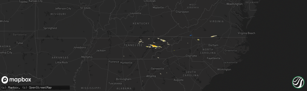
Hail Map on September 4, 2025
The weather event on September 4, 2025 includes Hail and Wind maps. 11 states and 145 cities were impacted and suffered possible damage. The total estimated number of properties impacted is 24,704.
Want more than just the map?
Turn this storm into a full workflow.
- Owner + property data so you know who to knock
- OnDemand branded weather history reports to win the "did we even have hail?" argument
- RoofTrace estimate so reps stop guessing numbers at the door
Bought this map? Upgrade within 7 days and we'll credit the $230. (10-15 min setup call)
Hail
Wind
24,704
Estimated number of impacted properties by a 1.00" hail or larger3,053
Estimated number of impacted properties by a 1.75" hail or larger0
Estimated number of impacted properties by a 2.50" hail or largerStates Impacted by Hail Map on September 4, 2025
Storm reports
Minnesota
| Date | Description |
|---|---|
| 09/04/20256:45 PM CDT | Delayed report. A tornado hit a farmstead... Knocking down and breaking multiple trees across the property. Timing via radar. No other damage reported yet. |
| 09/04/20256:20 PM CDT | Mping report of 3 inch tree |
| 09/04/20256:20 PM CDT | Mping report o |
| 09/04/20256:20 PM CDT | Mping report of 3 inch tree limbs broken. |
| 09/04/20255:29 PM CDT | A 3 inch tree was snapped half way down by thunderstorm wind gusts. |
| 09/04/20255:24 PM CDT | Awos station kmml marshall municipal airport. |
| 09/04/20255:23 PM CDT | Awos station kgdb granite falls ap. |
Tennessee
| Date | Description |
|---|---|
| 09/04/20253:00 PM CDT | A local report indicates 1.00 inch wind near 2 NNW Bradbury |
| 09/04/20252:50 PM CDT | Tree limbs down. |
| 09/04/20252:20 PM CDT | Several trees knocked down around mooresburg. |
| 09/04/20252:20 PM CDT | Several trees knocked down around mooresburg. |
| 09/04/20251:57 PM CDT | Report from mping: quarter |
| 09/04/20251:57 PM CDT | Report from mping: qu |
| 09/04/20251:55 PM CDT | Social media photo of large tree down across the road. Time estimated based on radar. |
| 09/04/20251:45 PM CDT | Large tree down over power lines. |
| 09/04/20251:40 PM CDT | Trees down around walter state college. |
| 09/04/20251:35 PM CDT | Social media video of dime to quarter size hail... Time estimated based on radar. |
| 09/04/20251:30 PM CDT | Large tree branch |
| 09/04/20251:30 PM CDT | A local report indicates 1.00 inch wind near 1 N Tazewell |
| 09/04/20251:07 PM CDT | Report from mping: quarter |
| 09/04/202512:35 PM CDT | A local report indicates 1.50 inch wind near 1 ENE Karns |
| 09/04/202512:35 PM CDT | Social media photo of multiple golf ball size hail stones. |
| 09/04/202512:30 PM CDT | Nickel to quarter-sized hail near hardin valley area. |
| 09/04/202512:30 PM CDT | Broadcast media report of half dollar size hail off of solway road. Similar report in karns. |
| 09/04/202512:10 PM CDT | A local report indicates 1.00 inch wind near 4 NE Cedar Creek |
| 09/04/202512:00 PM CDT | Trees blown down onto power lines. |
| 09/04/202511:55 AM CDT | Report of trees and powerlines down near fairview rd and coalfield school. Currently does not look to be located near where the funnel cloud was reported. |
| 09/04/202511:30 AM CDT | Social media photos of downed trees and power lines. Time estimated based on radar. |
| 09/04/202511:25 AM CDT | Trees down across cedar creek rd. |
| 09/04/202510:00 AM CDT | Reports of several trees down along cedar fork road east of tazewell. |
Oregon
| Date | Description |
|---|---|
| 09/04/20256:43 PM CDT | Mesonet station wtfo3 wagontire. |
Arizona
| Date | Description |
|---|---|
| 09/03/202510:25 PM CDT | At least a couple power lines down along avenue a near 3rd st and 5th st. Timing estimated from radar. |
| 09/03/202510:21 PM CDT | Power line down. Time estimated from radar. |
| 09/03/202510:10 PM CDT | Power line down. |
| 09/03/202510:10 PM CDT | 60 mph peak wind gust measured at yuma international airport |
| 09/03/20259:42 PM CDT | Highway 95 shut down due to a downed power line. Timing estimated from radar. |
| 09/03/20258:30 PM CDT | Bakers tank raws measured a 58 mph gust. Timing adjusted based on radar. |
| 09/03/20258:23 PM CDT | 58 mph wind gust measured at the mohawk dunes raws station. |
California
| Date | Description |
|---|---|
| 09/03/202510:25 PM CDT | Tree down on railroad ave blocking both lanes. Time estimated from radar. |
Virginia
| Date | Description |
|---|---|
| 09/04/20255:57 PM CDT | Report of large tree down off the side of the road on i-95 northbound near mile marker 60. Time estimated via radar. |
| 09/04/20254:27 PM CDT | Trees reported down along us-15 in the town of clarksville. Time is radar estimated. |
| 09/04/20253:55 PM CDT | Tree down blocking road near intersection of east hyco and loftis road. |
| 09/04/20253:53 PM CDT | 20-30 trees blown down... Multiple power lines down... Power pole snapped on newton farm road. |
| 09/04/20253:51 PM CDT | An intense thunderstorm moved across southern halifax county... Virginia during the afternoon of september 4th. A tornado formed within an area of straight-line damagin |
| 09/04/20253:51 PM CDT | Tree blown down along cherry hill church road. |
| 09/04/20253:23 PM CDT | Power line snapped along calvary road. |
| 09/04/20253:07 PM CDT | Tree down near intersection of oxford furnace road and country road. |
| 09/04/20253:06 PM CDT | Power lines down along smoky hollow road. |
| 09/04/20252:11 PM CDT | Tree down blocking iron ridge road near the bridge over little creek. Time estimated from radar. |
| 09/04/20252:00 PM CDT | A few trees were downed near stewartsville. |
| 09/04/20251:57 PM CDT | Power lines down on dell avenue near its intersection with ceylon street ne. Time estimated from radar. |
| 09/04/20251:55 PM CDT | Power lines down along stewart avenue. |
| 09/04/20251:55 PM CDT | Power line down near the intersection of herberger road nw and peters creek road nw. Time estimated from radar. |
| 09/04/20251:54 PM CDT | Power line down along sunrise avenue. |
| 09/04/20251:49 PM CDT | Power lines downed on noble avenue ne near the intersection with courtland road ne. Time estimated from radar. |
| 09/04/20251:44 PM CDT | Tree fell onto a power line on webbs mill road near its intersection with nursery lane. Time estimated from radar. |
| 09/04/20251:22 PM CDT | Tree down on cranberry road near kenwood lane. Time estimated from radar. |
| 09/04/20251:20 PM CDT | Roof blown off of building with people still inside. |
| 09/04/20251:16 PM CDT | Tree down on cliffview road near the ranger station on the new river trail. Time estimated from radar. |
| 09/04/20251:11 PM CDT | *** 1 inj *** tree fell on camper resulting in one injury. |
| 09/04/202510:55 AM CDT | Several trees down. |
Pennsylvania
| Date | Description |
|---|---|
| 09/04/20255:45 PM CDT | Wires down on road. Time estimated using radar. |
Kentucky
| Date | Description |
|---|---|
| 09/04/20259:39 AM CDT | The middlesboro police department posted pictures of a large tree down on balmoral road in between pike road and rochester avenue. The tree fell on power lines... And a |
| 09/04/20259:38 AM CDT | Picture on social media of downed trees blocking fairview road in middlesboro between mudlick road and gordon lane. Time estimated via radar. |
Texas
| Date | Description |
|---|---|
| 09/03/20257:53 PM CDT | Most likely caused by virga as winds gusted from the west-southwest with the only near by thunderstorm to the northeast. |
North Carolina
| Date | Description |
|---|---|
| 09/04/20254:40 PM CDT | Social media report of large branches downed along unity church rd. |
| 09/04/20254:30 PM CDT | Utility damage leading to outages near brawley school rd. |
| 09/04/20254:20 PM CDT | Trees downed near ivey church and union church roads. |
| 09/04/20254:05 PM CDT | Observed along laurel circle. |
| 09/04/20252:57 PM CDT | Tree down along pine hall road |
| 09/04/20252:57 PM CDT | Tree down along pine hall road. Time estimated from radar. |
| 09/04/20252:46 PM CDT | Tree down on dillard road in dillard. Time estimated from radar. |
| 09/04/20252:04 PM CDT | Tree down blocking one lane of woodville church road. |
| 09/04/20252:04 PM CDT | Tree down near intersection of wild boys lane and albion church road. |
| 09/04/20252:02 PM CDT | Tree down along w mount herman church and us 601 intersection. |
| 09/04/20251:58 PM CDT | Tree down near intersection of brim road and sheba trail. |
| 09/04/20251:57 PM CDT | Two trees down near mount herman church and brim road. |
| 09/04/20251:53 PM CDT | Tree down near intersection of snody road and athey simmons road. |
| 09/04/20251:50 PM CDT | Tree down on edgewood road near its intersection with walker street. Time estimated from radar. |
| 09/04/20251:48 PM CDT | Tree down near turkey ford baptist church. Time estimated from radar. |
| 09/04/20251:47 PM CDT | Tree down on springs road near riverside drive. Time estimated from radar. |
| 09/04/20251:38 PM CDT | Thunderstorm winds downed a tree at the intersection of edgewood road and walker street. Time estimated. |
| 09/04/20251:38 PM CDT | Tree down blocking country club road. |
| 09/04/20251:38 PM CDT | Tree down in the road near intersection of crossroad church road and judsville school road. Time estimated from radar. |
| 09/04/202512:41 PM CDT | 911 call center reported a tree down at the intersection of little helton road and jim duval road in ashe county north carolina. |
| 09/04/202512:38 PM CDT | Utility line damage leading to outages along culvin creek road. |
| 09/04/202512:30 PM CDT | Tree down on a power line on staggs creek road in warrensville... Nc. |
| 09/03/20257:35 PM CDT | Downed trees and/or utility lines leading to power outages. |
New York
| Date | Description |
|---|---|
| 09/04/20255:02 PM CDT | Photo of tree down on a house on flint town road. Time and exact location est |
| 09/04/20255:02 PM CDT | Photo of tree down on a house on flint town road. Time and exact location estimated by radar. |
| 09/04/20255:01 PM CDT | Large tree down. Time estimated from radar. |
| 09/04/20254:57 PM CDT | A thunderstorm moved through far northern oneida county around 6 pm on september 4th. It had broad rotation that tightened up as it approached ava ny. A weak |
| 09/04/20254:57 PM CDT | A thunderstorm moved through far northern oneida county around 6 pm on september 4th. It had broad rotation that tightened up as it approached ava ny. A weak tornado to |
| 09/04/20252:58 PM CDT | Tree down on ny-37 near serenity view campgro |
| 09/04/20252:58 PM CDT | Tree down on ny-37 near serenity view campground. |
| 09/04/20252:55 PM CDT | Tree down on wires and on fire at the intersection of state route 49 and meadowbrook lane. |
| 09/04/20252:40 PM CDT | Tree down on ny-37 near serenity view campground. |
| 09/04/20252:12 PM CDT | Tree down on new york route 812. |
| 09/04/20251:30 PM CDT | Tree down down on alexander street. |
| 09/04/20251:14 PM CDT | Tree down on dog hill rd. |
| 09/04/202512:43 PM CDT | Trees and wires down on peter scott rd. |
| 09/04/202512:12 PM CDT | Trees and wires down on emerson rd. |
| 09/04/202512:12 PM CDT | Trees down on cooper street. |
| 09/04/202511:30 AM CDT | A few reports of trees down in the town of geneva. |
Cities Impacted by Hail Map on September 4, 2025
- Butler, MO
- Adrian, MO
- Archie, MO
- Drexel, MO
- Greeneville, TN
- Oak Ridge, TN
- Oliver Springs, TN
- Knoxville, TN
- Clinton, TN
- Harriman, TN
- Speedwell, TN
- Lenoir City, TN
- Monterey, TN
- New Tazewell, TN
- Seymour, TN
- Louisville, TN
- Sevierville, TN
- Clarkrange, TN
- Wilkesboro, NC
- Morristown, TN
- Thorn Hill, TN
- Tazewell, TN
- Cookeville, TN
- Washburn, TN
- Bean Station, TN
- Rockford, TN
- Farragut, TN
- Galax, VA
- Woodlawn, VA
- Mooresburg, TN
- Russellville, TN
- Rutledge, TN
- Maryville, TN
- Rocky Top, TN
- Briceville, TN
- Frankewing, TN
- King, NC
- Westfield, NC
- Walnut Cove, NC
- Whitesburg, TN
- Danbury, NC
- Lawsonville, NC
- Rockwood, TN
- Germanton, NC
- Bulls Gap, TN
- Fayetteville, TN
- Petersburg, TN
- Kingston, TN
- Heiskell, TN
- Amargosa Valley, NV
- Rickman, TN
- Yucca, AZ
- Dolan Springs, AZ
- Santa Ysabel, CA
- Julian, CA
- Alton, VA
- South Boston, VA
- Prescott, AZ
- Livingston, TN
- Franklin, GA
- Roopville, GA
- Crawford, TN
- Virgilina, VA
- Alcoa, TN
- Black Mountain, NC
- Helenwood, TN
- Buffalo Junction, VA
- Clarksville, VA
- Statham, GA
- Bogart, GA
- Carlton, GA
- Maricopa, AZ
- Pine Valley, CA
- Campo, CA
- Watkinsville, GA
- Marshall, MN
- Vesta, MN
- Lucan, MN
- Milroy, MN
- Wabasso, MN
- Lamberton, MN
- Revere, MN
- Walnut Grove, MN
- Tracy, MN
- Oneida, TN
- Balaton, MN
- Garvin, MN
- Slayton, MN
- Lake Wilson, MN
- Currie, MN
- Avoca, MN
- Dovray, MN
- Westbrook, MN
- Redwood Falls, MN
- Wanda, MN
- Springfield, MN
- Clements, MN
- Morgan, MN
- Storden, MN
- Sanborn, MN
- Morton, MN
- Fairfax, MN
- Franklin, MN
- Jeffers, MN
- Sleepy Eye, MN
- Meadview, AZ
- New Ulm, MN
- Lafayette, MN
- Winthrop, MN
- Gibbon, MN
- Courtland, MN
- Gaylord, MN
- Nicollet, MN
- Saint Peter, MN
- Arlington, MN
- Henderson, MN
- Le Sueur, MN
- Mankato, MN
- Hackberry, AZ
- Bullhead City, AZ
- Kasota, MN
- Cleveland, MN
- Hayesville, NC
- Le Center, MN
- Hawthorne, NV
- Caliente, NV
- Roll, AZ
- Wellton, AZ
- Golden Valley, AZ
- Yuma, AZ
- Buffalo, OK
- Minneola, KS
- Mooreland, OK
- Scott City, KS
- Healy, KS
- Dighton, KS
- Waynoka, OK
- Cimarron, KS
- Ringwood, OK
- Enid, OK
- Chandler, OK
- Davenport, OK
- Somerton, AZ
- Mosheim, TN
- Oakdale, TN