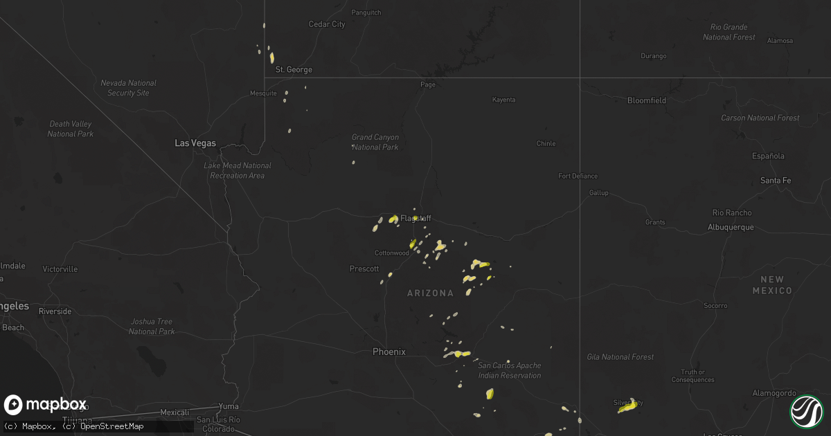
Hail Map on September 25, 2025
Get this storm
September 25 map
$229
one time, instant access
Download today. No call, no setup
Keep the $229
Bought the map and want the full workflow? Apply the entire $229 to a subscription within 7 days. None of it is wasted.
Every map, not just this one
This buys you this map. Subscription and you get every map we run, in the markets you choose from a few cities to whole states to nationwide. Plus real-time alerts the moment a storm fires.
Contact data
Name, contact info, occupancy, even credit band for addresses in the footprint. You go from where it hit to who to call.
Become the source they trust
Unlimited branding weather history reports on demand. You already have the documented answer ready for the property owner, and you are the one who showed up with it.
Property data and RoofTrace estimates
Pull up any address you have got, its value and the exact code rules for that jurisdiction, straight from One Click Code. Then RoofTrace estimates the squares, pitch, and roof value, priced the way you price.
States Impacted by Hail Map on September 25, 2025
Storm reports
New Mexico
| Date | Description |
|---|---|
| 09/25/20256:25 PM CDT | Corrects previous hail report from 3 s silver city. Public reported 1 inch measured hail after 30 minutes of melting. |
| 09/25/20256:25 PM CDT | Public reported 1 inch size hail. |
Utah
| Date | Description |
|---|---|
| 09/25/20256:27 PM CDT | Asos station kcdc c |
| 09/25/20256:27 PM CDT | Asos station kcdc cedar city municipal airport. |
| 09/25/20254:39 PM CDT | Asos station kcdc cedar city municipal airport. |
| 09/24/20257:00 PM CDT | Mesonet station pc471 black rock. |
North Carolina
| Date | Description |
|---|---|
| 09/25/20256:17 PM CDT | Power outage caused by storm damage. Time estimated by radar. |
| 09/25/20255:50 PM CDT | Downed trees reported down in benson along east harnett st.... Hodges chapel rd... And mingo rd. |
| 09/25/20253:54 PM CDT | A local report indicates 1.00 inch wind near 5 NNW Whiteville |
| 09/25/20258:49 AM CDT | A tree was blown down by thunderstorms winds near the intersection of cook school road and surry gadsberry road in the pilot mountain area. |
| 09/24/20259:30 PM CDT | Multiple downed trees reported around the county and in the area of lawsonville. |
Florida
| Date | Description |
|---|---|
| 09/25/202511:36 AM CDT | [landspout] both broadcast media and emergency management shared images and reports of a landspout over the pinellas county landfill. This landspout was observed under |
Texas
| Date | Description |
|---|---|
| 09/24/202510:15 PM CDT | Outflow winds blew over tree and pulled down a powerline leaving the area around the el pavon apartments without power. |
Arizona
| Date | Description |
|---|---|
| 09/25/20256:12 PM CDT | Report from trained spotter of quarter size hail at thorpe park. |
| 09/25/20255:30 PM CDT | Photo from social media showing quarter sized hail in parks. |
| 09/25/20255:23 PM CDT | Social media photo of hail in garland prairie. Size estimated from photo. |
| 09/25/20255:15 PM CDT | Social media photo of hail. Size estimated from photo. |
| 09/25/20254:20 PM CDT | Social media post about 1 inch hail. Time estimated based on radar. |
| 09/25/20254:13 PM CDT | Social media post about 1 inch hail. Time estimated based on radar. |
| 09/25/20253:50 PM CDT | Quarter-sized hail reported in miami. Location approximated. |
Virginia
| Date | Description |
|---|---|
| 09/25/20255:15 PM CDT | Reports of trees down on route 9 north of purcellville... Tranquility road... And hillsboro road. Wires also down on hamilton station road. |
| 09/25/20255:15 PM CDT | Reports of trees down on route 9 north of purcel |
| 09/25/20253:20 PM CDT | *** 1 inj *** tree fell on a ups truck near the intersection of blounts corner rd and days point rd. Time estimated from radar. |
| 09/25/202512:10 AM CDT | A tree was reported downed onto powerlines on ontario road. Time is radar-estimated. |
| 09/25/202512:05 AM CDT | Multiple trees down along friendship church rd and w point stevens rd. |
| 09/24/202511:40 PM CDT | Multiple trees down in clover community. |
| 09/24/202510:00 PM CDT | Downed trees reported scattered across henry county. |
New York
| Date | Description |
|---|---|
| 09/25/202511:05 AM CDT | Trees down on house with some resultant damage in the jeffersonville area. Exact location uncertain... Radar-estimated time. |
| 09/25/202510:57 AM CDT | Just before noon... A storm along a warm front separated from the rest of the line and began to rotate. With a favorable environment but low instability... A weak torna |
Pennsylvania
| Date | Description |
|---|---|
| 09/25/20254:03 PM CDT | Tree and wire down on road. Time estimated by radar. |
| 09/25/20253:11 PM CDT | Trees down on wires. Wires sparking. Time estimated from radar. |
| 09/25/20252:25 PM CDT | Tree down on mountain road between pine tree road and rt 234 franklin township. |
Cities Impacted by Hail Map on September 25, 2025
- Livingston Manor, NY
- Roscoe, NY
- Richland, GA
- Forest Lakes, AZ
- Winslow, AZ
- Heber, AZ
- Show Low, AZ
- Saint David, AZ
- Huachuca City, AZ
- Tucson, AZ
- Daytona Beach, FL
- Kearny, AZ
- Port Orange, FL
- New Smyrna Beach, FL
- Sierra Vista, AZ
- Tombstone, AZ
- Elfrida, AZ
- Smithfield, VA
- Carrollton, VA
- Willcox, AZ
- Miami, AZ
- Bladenboro, NC
- Clarkton, NC
- Whiteville, NC
- Claypool, AZ
- Globe, AZ
- Deltona, FL
- San Manuel, AZ
- McNeal, AZ
- Vail, AZ
- Pearce, AZ
- Williams, AZ
- Douglas, AZ
- Shelby, NC
- Grover, NC
- Coats, NC
- Lillington, NC
- Supai, AZ
- Flagstaff, AZ
- Dunn, NC
- Benson, NC
- Erwin, NC
- Angier, NC
- Bowie, AZ
- Chesnee, SC
- Inman, SC
- Four Oaks, NC
- Campobello, SC
- Safford, AZ
- San Simon, AZ
- Arenas Valley, NM
- Silver City, NM
- Santa Clara, NM
- Smithfield, NC
- Cowpens, SC
- Mayo, SC
- Gaffney, SC
- Boiling Springs, SC
- Tyrone, NM
- Duncan, AZ
- Selma, NC
- Bayard, NM
- Hurley, NM
- Gaston, NC
- Emporia, VA
- Garysburg, NC
- Skippers, VA
- Sedona, AZ
- Saint George, UT
- Deming, NM
- Gloucester Point, VA
- Hayes, VA
- Danbury, NC
- Lawsonville, NC
- Tonto Basin, AZ
- Munds Park, AZ
- Birdsnest, VA
- Nassawadox, VA
- Rio Rico, AZ
- Mormon Lake, AZ
- Tumacacori, AZ
- Keysville, VA
- Victoria, VA
- Meherrin, VA
- Green Bay, VA
- Wylliesburg, VA
- Saxe, VA
- Red Oak, VA
- Drakes Branch, VA
- Chase City, VA
- Lunenburg, VA
- Dendron, VA
- Waverly, VA
- Wakefield, VA
- Elberon, VA
- Ivor, VA
- Newport News, VA
- Machipongo, VA
- Fort Mcdowell, AZ
- Peridot, AZ
- Oracle, AZ
- Mayer, AZ