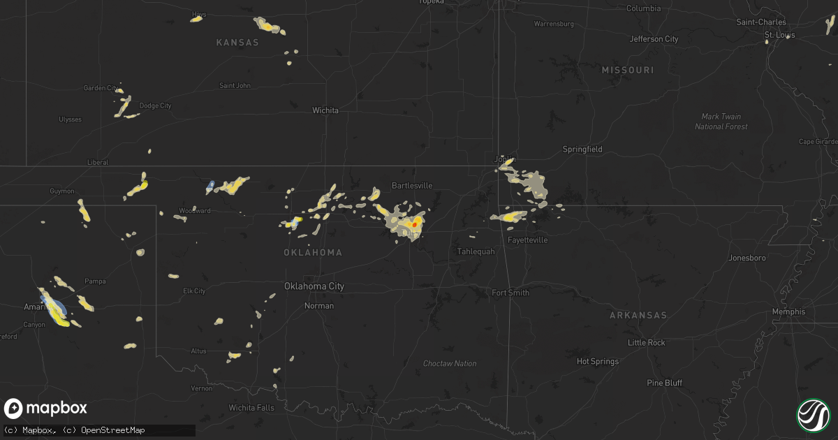
Hail Map on September 20, 2025
Get this storm
September 20 map
$229
one time, instant access
Download today. No call, no setup
Keep the $229
Bought the map and want the full workflow? Apply the entire $229 to a subscription within 7 days. None of it is wasted.
Every map, not just this one
This buys you this map. Subscription and you get every map we run, in the markets you choose from a few cities to whole states to nationwide. Plus real-time alerts the moment a storm fires.
Contact data
Name, contact info, occupancy, even credit band for addresses in the footprint. You go from where it hit to who to call.
Become the source they trust
Unlimited branding weather history reports on demand. You already have the documented answer ready for the property owner, and you are the one who showed up with it.
Property data and RoofTrace estimates
Pull up any address you have got, its value and the exact code rules for that jurisdiction, straight from One Click Code. Then RoofTrace estimates the squares, pitch, and roof value, priced the way you price.
States Impacted by Hail Map on September 20, 2025
Storm reports
Wisconsin
| Date | Description |
|---|---|
| 09/20/20256:20 PM CDT | Tree down. Time estimated by dispatch. |
Illinois
| Date | Description |
|---|---|
| 09/20/20254:15 PM CDT | Report of a tree split and several large 6 to 8 inch branches down in pana. |
| 09/20/20254:10 PM CDT | Estimated 60 mph wind gusts along hwy 161 a few miles west of mount erie. |
| 09/20/20252:00 PM CDT | Relayed by wcia tv media. |
| 09/20/20251:15 PM CDT | Relayed by wcia tv media. |
Missouri
| Date | Description |
|---|---|
| 09/19/202511:20 PM CDT | A tree down in the area of highway 97 and state highway b and highway t. |
| 09/19/202510:40 PM CDT | Hail to the size of quarters fell at highway 37 and farm road 2212. |
| 09/19/202510:15 PM CDT | A tree was down due to thunderstorm winds on highway 76 at farm road 2150. |
Ohio
| Date | Description |
|---|---|
| 09/20/20253:16 PM CDT | A local report indicates 1.00 inch wind near 3 NNW Neffs |
Michigan
| Date | Description |
|---|---|
| 09/20/20256:48 PM CDT | Much of the west half of fennville is without power. At least one line and several large tree branches witnessed down. A very large tree on the road at 118th ave near 4 |
| 09/20/20256:00 PM CDT | A local report indicates 1.00 inch wind near Marcellus |
| 09/19/20257:39 PM CDT | Trees and wires down on road. |
| 09/19/20257:10 PM CDT | A few trees down blocking roads in zeeland twp. A tree down in zeeland damaged a backyard shed and play structure. |
Oklahoma
| Date | Description |
|---|---|
| 09/20/20256:27 PM CDT | Measured by mobile mesonet. Also power poles down on wood rd. Between cleveland and oakwood. |
| 09/20/20256:27 PM CDT | Measured by mobile mesonet. Also power poles down on wood rd. Between clevelan |
| 09/20/20256:20 PM CDT | A local report indicates 1.00 inch wind near 4 SE Billings |
| 09/20/20255:37 PM CDT | A local report indicates 1.00 inch wind near 4 S Fairmont |
| 09/20/20255:05 PM CDT | Freedom mesonet site. |
| 09/19/202510:11 PM CDT | A local report indicates 63 MPH wind near 4 SW Catoosa |
| 09/19/20259:03 PM CDT | Report from mping: quarter |
| 09/19/20258:50 PM CDT | Report from mping: quarter |
| 09/19/20258:48 PM CDT | Golf ball size hail. |
| 09/19/20258:35 PM CDT | Half dollar size hail. |
| 09/19/20258:35 PM CDT | Half do |
| 09/19/20258:34 PM CDT | Report from mping: half dollar |
| 09/19/20257:01 PM CDT | A local report indicates 1.00 inch wind near 2 S Waukomis |
Utah
| Date | Description |
|---|---|
| 09/19/20257:40 PM CDT | Measured at the causeway mesonet site. |
Indiana
| Date | Description |
|---|---|
| 09/20/20253:35 PM CDT | A few large trees and limbs snapped. Powerline down as well. |
Arkansas
| Date | Description |
|---|---|
| 09/20/202512:01 AM CDT | A local report indicates 1.25 inch wind near Decatur |
Texas
| Date | Description |
|---|---|
| 09/20/20256:00 PM CDT | Local media reported truck and camper flipped over on us 287 a mile east of washburn. |
| 09/20/20255:15 PM CDT | A local report indicates 75 MPH wind near 4 SSW Pantex |
| 09/19/20259:01 PM CDT | A local report indicates 64 MPH wind near 10 ENE Palo Duro Canyon |
| 09/19/20259:01 PM CDT | Peak wind gust of 64 mph measured at 9:01 pm. First severe gust of 60 mph at 8:58 pm and last severe gust of 59 mph measured at 9:03 pm. |
| 09/19/20258:01 PM CDT | Report from mping: quarter |
| 09/19/20257:58 PM CDT | Public call for quarter sized hail that was accumulating. |
Cities Impacted by Hail Map on September 20, 2025
- Rose, OK
- Hulbert, OK
- Peggs, OK
- Tahlequah, OK
- Pleasant Plains, IL
- New Berlin, IL
- Carlyle, IL
- Atlanta, IL
- McLean, IL
- Sandoval, IL
- Patoka, IL
- Waverly, IL
- Winnsboro, SC
- Odin, IL
- Springfield, IL
- Waynesville, IL
- Chatham, IL
- Loami, IL
- Caldwell, OH
- Hendersonville, NC
- Altamont, IL
- Mason, IL
- Fenton, MO
- Saint Louis, MO
- Centralia, IL
- Majestic, KY
- Greenville, IL
- Rochester, IL
- Graysville, PA
- Keyesport, IL
- Henrico, VA
- Lindon, CO
- Matewan, WV
- East Saint Louis, IL
- Fairview Heights, IL
- Belleville, IL
- Edinburg, IL
- Monroe City, MO
- Dawson, IL
- Mechanicsburg, IL
- Smithboro, IL
- Perry, MO
- Center, MO
- Hillsboro, NM
- Mount Auburn, IL
- Cumberland, OH
- Caseyville, IL
- Necedah, WI
- Watson, IL
- Ridge Spring, SC
- Johnston, SC
- Pocahontas, IL
- Mcconnelsville, OH
- Mason City, IL
- Emden, IL
- San Jose, IL
- Lore City, OH
- Easton, IL
- Bellaire, OH
- Bridgeport, OH
- Limon, CO
- Balko, OK
- Beaver, OK
- Stockport, OH
- Laverne, OK
- Beason, IL
- Lincoln, IL
- Matheson, CO
- Cambridge, OH
- Saint Clairsville, OH
- New Concord, OH
- Carnegie, OK
- Apache, OK
- Carmichaels, PA
- Mount Morris, PA
- Ramsey, IL
- Bingham, IL
- Oconee, IL
- Nekoosa, WI
- Waurika, OK
- Fort Cobb, OK
- Maidsville, WV
- Wisconsin Rapids, WI
- Hastings, OK
- Dilliner, PA
- Morgantown, WV
- Comanche, OK
- Temple, OK
- Fairfield, IL
- Anadarko, OK
- Folsom, NM
- Greensboro, PA
- Granville, WV
- Gate, OK
- Bobtown, PA
- Stevens Point, WI
- Griggsville, IL
- Cope, CO
- Walters, OK
- Wild Rose, WI
- Wautoma, WI
- Cisne, IL
- Mount Erie, IL
- Trevor, WI
- Salem, WI
- Pana, IL
- Duncan, OK
- Grenville, NM
- Ohiopyle, PA
- Chalk Hill, PA
- Farmington, PA
- Flagler, CO
- Waupaca, WI
- Gracemont, OK
- Binger, OK
- Seibert, CO
- Hardesty, OK
- Minco, OK
- Piney Flats, TN
- Woodward, OK
- Fort Supply, OK
- Amarillo, TX
- Antioch, IL
- Crescent, OK
- Mooreland, OK
- Johnsonville, IL
- Clay City, IL
- Marlow, OK
- Ramah, CO
- Fairmont, OK
- Enid, OK
- Covington, OK
- Fremont, WI
- Burlington, WI
- Hennessey, OK
- Meade, KS
- Lake Geneva, WI
- Genoa City, WI
- Panhandle, TX
- Dowagiac, MI
- Bristol, WI
- Claude, TX
- Cassopolis, MI
- Clarington, OH
- Spearman, TX
- Vici, OK
- Nashville, IL
- Kansasville, WI
- Hortonville, WI
- New London, WI
- Newburg, WV
- Tunnelton, WV
- Marshall, OK
- Perry, OK
- Larsen, WI
- Freedom, OK
- Orlando, OK
- Allegan, MI
- Silver Lake, WI
- Bison, OK
- Shattuck, OK
- Ringwood, OK
- Garber, OK
- Vandalia, MI
- Terra Alta, WV
- Indiahoma, OK
- Marcellus, MI
- Rowlesburg, WV
- Snyder, OK
- Loveland, OK
- Frederick, OK
- Billings, OK
- Lucien, OK
- Waukomis, OK
- Jones, MI
- Perryton, TX
- Cache, OK
- Drummond, OK
- Douglas, OK
- Fargo, OK
- Sharon, OK
- Groom, TX
- Lawton, OK
- Red Rock, OK
- Marland, OK
- Medicine Park, OK
- Hominy, OK
- Ralston, OK
- Oologah, OK
- Collinsville, OK
- Ordway, CO
- Fennville, MI
- Holland, MI
- Hamilton, MI
- Hopkins, MI
- Hobart, OK
- Waltonville, IL
- Mount Vernon, IL
- Canadian, TX
- Pawnee, OK
- Tonkawa, OK
- Carthage, IL
- Fairfax, OK
- Pond Creek, OK
- Ravenna, MI
- Skiatook, OK
- Ponca City, OK
- Dorr, MI
- Gotebo, OK
- Barnsdall, OK
- Higgins, TX
- Trinidad, CO
- Branson, CO
- Sperry, OK
- Waynoka, OK
- Owasso, OK
- Burbank, OK
- Pawhuska, OK
- Stella, MO
- Fairview, MO
- Decatur, MI
- Tulsa, OK
- Alva, OK
- Wheaton, MO
- Neosho, MO
- Seneca, MO
- Quapaw, OK
- Model, CO
- Prue, OK
- Osage, OK
- Talala, OK
- Ramona, OK
- Granby, MO
- Purdy, MO
- Goodman, MO
- Sand Springs, OK
- Cleveland, OK
- Mannford, OK
- Akron, CO
- Cassville, MO
- Rocky Comfort, MO
- Washburn, MO
- Exeter, MO
- Sapulpa, OK
- Catoosa, OK
- Fritch, TX
- Pierce City, MO
- Monett, MO
- Stark City, MO
- Broken Arrow, OK
- Joplin, MO
- Pritchett, CO
- Carthage, MO
- Diamond, MO
- Memphis, TX
- Jay, OK
- Decatur, AR
- Hiwasse, AR
- Gravette, AR
- Sulphur Springs, AR
- Bella Vista, AR
- Bentonville, AR
- Gentry, AR
- Duenweg, MO
- Las Animas, CO
- Colcord, OK
- Centerton, AR
- Butterfield, MO
- Rogers, AR
- Seligman, MO
- White Deer, TX
- Maysville, AR
- Jenks, OK
- Garfield, AR
- Clarendon, TX
- Shamrock, TX
- Hindsville, AR
- Pea Ridge, AR
- Eagle Rock, MO
- Golden, MO
- Eureka Springs, AR
- Berryville, AR
- Pampa, TX
- Huntsville, AR
- Copeland, KS
- Montezuma, KS
- Cimarron, KS
- Siloam Springs, AR
- Anderson, MO
- Lowell, AR
- Ingalls, KS
- Garden City, KS
- Childress, TX
- Inman, KS
- Wilson, KS
- Ellsworth, KS
- Dyersburg, TN
- Little River, KS
- Hays, KS
- Windom, KS
- Kanopolis, KS
- Marquette, KS
- Geneseo, KS
- Cheyenne, OK
- Mcpherson, KS