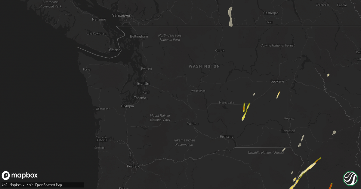
Hail Map in Washington on August 12, 2022
Get this storm
August 12 map
$229
one time, instant access
Download today. No call, no setup
Keep the $229
Bought the map and want the full workflow? Apply the entire $229 to a subscription within 7 days. None of it is wasted.
Every map, not just this one
This buys you this map. Subscription and you get every map we run, in the markets you choose from a few cities to whole states to nationwide. Plus real-time alerts the moment a storm fires.
Contact data
Name, contact info, occupancy, even credit band for addresses in the footprint. You go from where it hit to who to call.
Become the source they trust
Unlimited branding weather history reports on demand. You already have the documented answer ready for the property owner, and you are the one who showed up with it.
Property data and RoofTrace estimates
Pull up any address you have got, its value and the exact code rules for that jurisdiction, straight from One Click Code. Then RoofTrace estimates the squares, pitch, and roof value, priced the way you price.
Storm reports in Washington
Washington
| Date | Description |
|---|---|
| 08/12/202211:15 AM CDT | A local report indicates 1.00 inch wind near 7 ENE LIND |
| 08/12/202211:09 AM CDT | Twitter report. |
| 08/12/202210:30 AM CDT | Picture report from facebook. |
| 08/12/20223:46 AM CDT | At 846 AM PDT, a severe thunderstorm was located 10 miles north of Kahlotus, or 12 miles northeast of Connell, moving north at 25 mph. HAZARD...Half dollar size hail. SOURCE...Radar indicated. IMPACT...Damage to vehicles is expected. Locations impacted include... Lind, Ralston, Pizzro and Paha. This includes Interstate 90 in Washington between mile markers 208and 218. |
| 08/12/20223:29 AM CDT | At 829 AM PDT, a severe thunderstorm was located 14 miles southeast of Cheney, moving northeast at 30 mph. HAZARD...Half dollar size hail. SOURCE...Radar indicated. IMPACT...Damage to vehicles is expected. Locations impacted include... Rockford, Spangle, Plaza, Mica and Valleyford. |
All States Impacted by Hail Map on August 12, 2022
Cities Impacted by Hail Map on August 12, 2022
- Heart Butte, MT
- Craigmont, ID
- Cottonwood, ID
- Harrington, WA
- Oneill, NE
- Emmet, NE
- Lind, WA
- Ogden, UT
- Ritzville, WA
- Wickenburg, AZ
- Oroville, WA
- Trout Creek, MT
- Thompson Falls, MT
- Canton, MN
- Mabel, MN
- Dorchester, IA
- Decorah, IA
- Spring Grove, MN
- Mountain Home, ID
- Bruneau, ID
- Murphy, ID
- Judith Gap, MT
- Shawmut, MT
- Pendroy, MT
- Florence, AZ
- Garden Valley, ID
- Mccall, ID
- Cascade, ID
- Sedona, AZ
- Elma, IA
- Riceville, IA
- Verdigre, NE
- Imnaha, OR
- Lima, MT
- Halfway, OR
- Council, ID
- Oxbow, OR
- Cascade, MT
- Niobrara, NE
- Cambridge, ID
- Philipsburg, MT
- Fort Mill, SC
- Connell, WA
- Elk City, ID
- Rosalia, WA
- Spangle, WA
- Tucson, AZ
- Humboldt, AZ
- Dewey, AZ
- Scottsdale, AZ
- Bosler, WY
- Grand View, ID
- Sanford, FL
- Lake Mary, FL
- Paradise Valley, AZ
- Boise, ID
- Indian Valley, ID
- Lucile, ID
- Riggins, ID
- Loring, MT
- Bingham Canyon, UT
- West Jordan, UT
- Whitewater, MT
- Stuart, NE
- Mesa, AZ
- Mountain Home Afb, ID
- Atkinson, NE
- Fountain Hills, AZ
- Fort Mcdowell, AZ
- Phoenix, AZ
- Sells, AZ
- Shiner, TX
- Enterprise, OR
- Mesa, ID
- Superior, AZ
- Maricopa, AZ
- Tonopah, AZ
- Queen Creek, AZ
- Louise, TX
- Apache Junction, AZ
- Lynch, NE
- King Hill, ID
- Yellow Pine, ID
- Fairfield, WA
- Charlotte, NC


