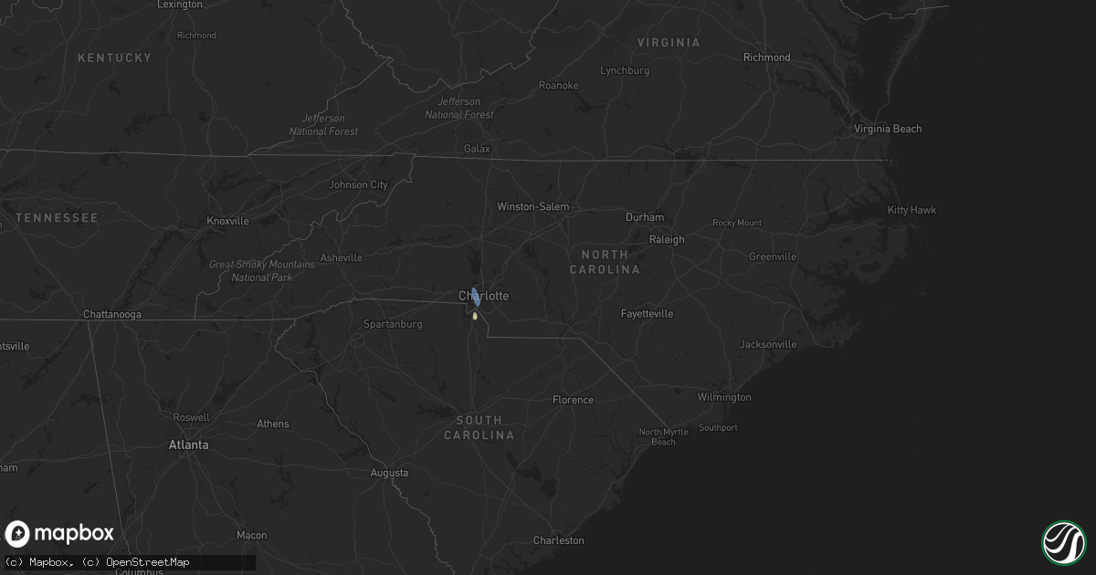
Hail Map in North Carolina on August 12, 2022
Get this storm
August 12 map
$229
one time, instant access
Download today. No call, no setup
Keep the $229
Bought the map and want the full workflow? Apply the entire $229 to a subscription within 7 days. None of it is wasted.
Every map, not just this one
This buys you this map. Subscription and you get every map we run, in the markets you choose from a few cities to whole states to nationwide. Plus real-time alerts the moment a storm fires.
Contact data
Name, contact info, occupancy, even credit band for addresses in the footprint. You go from where it hit to who to call.
Become the source they trust
Unlimited branding weather history reports on demand. You already have the documented answer ready for the property owner, and you are the one who showed up with it.
Property data and RoofTrace estimates
Pull up any address you have got, its value and the exact code rules for that jurisdiction, straight from One Click Code. Then RoofTrace estimates the squares, pitch, and roof value, priced the way you price.
Storm reports in North Carolina
North Carolina
| Date | Description |
|---|---|
| 08/12/20225:09 PM CDT | Corrects previous tstm wnd gst report from kclt. Asos station kclt charlotte international airport. |
| 08/12/20225:07 PM CDT | Report of trees down near the vineyards on lake wylie near the charlotte international airport. |
| 08/12/20224:52 PM CDT | 911 call center reported multiple trees and power lines down throughout the city of mount holly. |
| 08/12/20224:34 PM CDT | Tree down on roadway in town of stanley. |
| 08/12/20224:17 PM CDT | Tree down across roadway in the town of vale. |
| 08/12/20224:15 PM CDT | Tree down across roadway in city of lincolnton. |
| 08/12/20224:05 PM CDT | Tree blocking roadway in the city of maiden. |
| 08/12/20224:05 PM CDT | Trees and power lines down in town of stanley. |
| 08/12/20223:48 PM CDT | Powerlines down across roadway in the city of newton. |
| 08/12/20223:37 PM CDT | Multiple reports of trees and power lines down in the city of conover. |
All States Impacted by Hail Map on August 12, 2022
Cities Impacted by Hail Map on August 12, 2022
- Heart Butte, MT
- Craigmont, ID
- Cottonwood, ID
- Harrington, WA
- Oneill, NE
- Emmet, NE
- Lind, WA
- Ogden, UT
- Ritzville, WA
- Wickenburg, AZ
- Oroville, WA
- Trout Creek, MT
- Thompson Falls, MT
- Canton, MN
- Mabel, MN
- Dorchester, IA
- Decorah, IA
- Spring Grove, MN
- Mountain Home, ID
- Bruneau, ID
- Murphy, ID
- Judith Gap, MT
- Shawmut, MT
- Pendroy, MT
- Florence, AZ
- Garden Valley, ID
- Mccall, ID
- Cascade, ID
- Sedona, AZ
- Elma, IA
- Riceville, IA
- Verdigre, NE
- Imnaha, OR
- Lima, MT
- Halfway, OR
- Council, ID
- Oxbow, OR
- Cascade, MT
- Niobrara, NE
- Cambridge, ID
- Philipsburg, MT
- Fort Mill, SC
- Connell, WA
- Elk City, ID
- Rosalia, WA
- Spangle, WA
- Tucson, AZ
- Humboldt, AZ
- Dewey, AZ
- Scottsdale, AZ
- Bosler, WY
- Grand View, ID
- Sanford, FL
- Lake Mary, FL
- Paradise Valley, AZ
- Boise, ID
- Indian Valley, ID
- Lucile, ID
- Riggins, ID
- Loring, MT
- Bingham Canyon, UT
- West Jordan, UT
- Whitewater, MT
- Stuart, NE
- Mesa, AZ
- Mountain Home Afb, ID
- Atkinson, NE
- Fountain Hills, AZ
- Fort Mcdowell, AZ
- Phoenix, AZ
- Sells, AZ
- Shiner, TX
- Enterprise, OR
- Mesa, ID
- Superior, AZ
- Maricopa, AZ
- Tonopah, AZ
- Queen Creek, AZ
- Louise, TX
- Apache Junction, AZ
- Lynch, NE
- King Hill, ID
- Yellow Pine, ID
- Fairfield, WA
- Charlotte, NC


