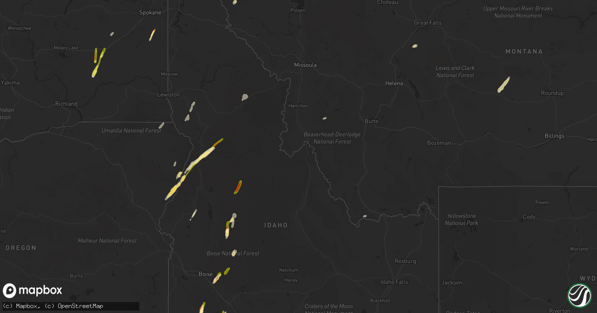
Hail Map in Idaho on August 12, 2022
Get this storm
August 12 map
$229
one time, instant access
Download today. No call, no setup
Keep the $229
Bought the map and want the full workflow? Apply the entire $229 to a subscription within 7 days. None of it is wasted.
Every map, not just this one
This buys you this map. Subscription and you get every map we run, in the markets you choose from a few cities to whole states to nationwide. Plus real-time alerts the moment a storm fires.
Contact data
Name, contact info, occupancy, even credit band for addresses in the footprint. You go from where it hit to who to call.
Become the source they trust
Unlimited branding weather history reports on demand. You already have the documented answer ready for the property owner, and you are the one who showed up with it.
Property data and RoofTrace estimates
Pull up any address you have got, its value and the exact code rules for that jurisdiction, straight from One Click Code. Then RoofTrace estimates the squares, pitch, and roof value, priced the way you price.
Storm reports in Idaho
Idaho
| Date | Description |
|---|---|
| 08/12/20226:00 PM CDT | Spotter reported isolated golf ball size hail dropping out of passing thunderstorm. |
| 08/12/20225:00 PM CDT | Via social media. Time is approximate. |
| 08/12/20224:24 PM CDT | Tree was reportedly down near mile markers 143 and 144 on us-12. |
| 08/12/20224:20 PM CDT | Hail between quarter and half dollar size reported from salmon rapids lodge. Lots of leaves down but no other observed damage at this time. |
| 08/12/20224:20 PM CDT | Hail between quarter and half dollar size reported from salmon rapids lodge. Lots of le |
| 08/12/20223:39 PM CDT | Hail ranging from quarter to ping pong. Via social media. |
| 08/12/20222:52 PM CDT | Strong thunderstorm winds estimated near 60 mph. Half inch hail also fell with the storm. |
| 08/12/20227:52 AM CDT | At 1252 PM PDT, severe thunderstorms were located along a line extending from 8 miles east of Culdesac to 14 miles south of Craigmont, moving northeast at 45 mph. HAZARD...60 mph wind gusts and half dollar size hail. SOURCE...Radar indicated. IMPACT...Hail damage to vehicles is expected. Expect wind damage to roofs, siding, and trees. Locations impacted include... Kamiah, Craigmont, Nezperce, Winchester, Peck, Reubens, Mohler and Gifford.This includes the following highways... U.S. Highway 95 in Idaho between mile markers 268 and 288. U.S. Highway 12 in Idaho between mile markers 32 and 34, betweenmile markers 52 and 54, and between mile markers 59 and 67. |
| 08/12/20227:51 AM CDT | At 1251 PM MDT, a severe thunderstorm was located near Council Mountain, or 9 miles southwest of McCall, moving northeast at 40 mph. HAZARD...60 mph wind gusts and half dollar size hail. SOURCE...Radar indicated. IMPACT...Hail damage to vehicles is expected. Expect wind damage to roofs, siding, and trees. This severe thunderstorm will be near... McCall around 100 PM MDT. Payette Lake, Little Payette Lake and Lake Fork Guard Station around 110 PM MDT. Lick Creek Summit around 120 PM MDT. Ponderosa Campground and Upper Payette Lake around 130 PM MDT. |
| 08/12/20221:11 AM CDT | At 611 PM MDT, a severe thunderstorm was located over Monumental Peak, or 25 miles north of Lowman, moving north at 20 mph. HAZARD...Ping pong ball size hail and 60 mph wind gusts. SOURCE...Radar indicated. IMPACT...People and animals outdoors will be injured. Expect hail damage to roofs, siding, windows, and vehicles. Expect wind damage to roofs, siding, and trees. This severe thunderstorm will be near... Deadwood Summit around 630 PM MDT. Warm Lake and Big Creek Summit around 650 PM MDT. Landmark around 700 PM MDT. |
| 08/12/202212:32 AM CDT | At 531 PM MDT, a severe thunderstorm was located near Deadwood Reservoir, or 11 miles north of Lowman, moving northeast at 50 mph. HAZARD...Ping pong ball size hail and 60 mph wind gusts. SOURCE...Radar indicated. IMPACT...People and animals outdoors will be injured. Expect hail damage to roofs, siding, windows, and vehicles. Expect wind damage to roofs, siding, and trees. This severe thunderstorm will be near... Deer Creek Pass, Bear Valley Campground and Monumental Peak around 550 PM MDT. Sulphur Creek Ranch and Deadwood Summit around 600 PM MDT. Boundary Creek Launch Site, Dagger Falls and Landmark around 610 PM MDT. |
| 08/11/202211:28 PM CDT | At 428 PM MDT, a severe thunderstorm was located near Deadwood Summit, or 28 miles north of Lowman, moving northeast at 40 mph. HAZARD...Half dollar size hail. SOURCE...Radar indicated. IMPACT...Damage to vehicles is expected. This severe thunderstorm will be near... Deadwood Summit around 430 PM MDT. Landmark, Sulphur Creek Ranch and Warm Lake around 440 PM MDT. Halfway Station around 450 PM MDT. Pistol Rock around 500 PM MDT. |
| 08/11/202211:21 PM CDT | At 421 PM MDT, a severe thunderstorm was located near Crows Nest Butte, or 19 miles south of Glenns Ferry, moving north at 20 mph. HAZARD...60 mph wind gusts and half dollar size hail. SOURCE...Radar indicated. IMPACT...Hail damage to vehicles is expected. Expect wind damage to roofs, siding, and trees. This severe thunderstorm will be near... Deadman Flat around 450 PM MDT. Twentymile Butte around 500 PM MDT. |
| 08/11/202211:13 PM CDT | At 413 PM MDT, a severe thunderstorm was located over Lucky Peak Reservoir, or 14 miles east of Boise, moving northeast at 25 mph. HAZARD...Ping pong ball size hail and 60 mph wind gusts. SOURCE...Radar indicated. IMPACT...People and animals outdoors will be injured. Expect hail damage to roofs, siding, windows, and vehicles. Expect wind damage to roofs, siding, and trees. This severe thunderstorm will be near... Arrowrock Dam around 420 PM MDT. Arrowrock Reservoir and Twin Springs around 440 PM MDT. Thorn Creek Summit around 450 PM MDT. Idaho City, Barber Flat Guard Station and Harris Creek Summit around 500 PM MDT. |
| 08/11/202211:12 PM CDT | At 411 PM MDT, a severe thunderstorm was located near Big Foot Butte, or 27 miles west of Mountain Home, moving north at 35 mph. HAZARD...Half dollar size hail. SOURCE...Radar indicated. IMPACT...Damage to vehicles is expected. This severe thunderstorm will be near... Big Foot Butte around 420 PM MDT. Swan Falls around 430 PM MDT. Initial Point around 440 PM MDT. |
| 08/11/202211:03 PM CDT | At 403 PM MDT, a severe thunderstorm was located near Crows Nest Butte, or 24 miles south of Glenns Ferry, moving north at 20 mph. HAZARD...Ping pong ball size hail and 60 mph wind gusts. SOURCE...Radar indicated. IMPACT...People and animals outdoors will be injured. Expect hail damage to roofs, siding, windows, and vehicles. Expect wind damage to roofs, siding, and trees. This severe thunderstorm will remain over mainly rural areas of south central Elmore and east central Owyhee Counties. |
| 08/11/202211:02 PM CDT | At 402 PM MDT, a severe thunderstorm was located near Deadwood Summit, or 29 miles north of Lowman, moving north at 25 mph. HAZARD...Quarter size hail. SOURCE...Radar indicated. IMPACT...Damage to vehicles is expected. This severe thunderstorm will be near... Sulphur Creek Ranch and Boundary Creek Launch Site around 410 PM MDT. Landmark around 430 PM MDT. |
| 08/11/202210:48 PM CDT | At 348 PM MDT, a severe thunderstorm was located near Twin Springs, or 15 miles south of Idaho City, moving north at 35 mph. HAZARD...Quarter size hail. SOURCE...Radar indicated. IMPACT...Damage to vehicles is expected. This severe thunderstorm will be near... Thorn Creek Summit and Twin Springs around 400 PM MDT. Idaho City, Barber Flat Guard Station and Dutch Creek Guard Station around 410 PM MDT. |
| 08/11/202210:46 PM CDT | At 346 PM MDT, a severe thunderstorm was located over Lucky Peak Dam, or 12 miles southeast of Boise, moving north at 40 mph. HAZARD...60 mph wind gusts and half dollar size hail. SOURCE...Radar indicated. IMPACT...Hail damage to vehicles is expected. Expect wind damage to roofs, siding, and trees. This severe thunderstorm will be near... Lucky Peak Reservoir, Arrowrock Dam, Lucky Peak Spring Shores Marina and Aldape Summit around 400 PM MDT. Arrowrock Reservoir around 410 PM MDT. |
| 08/11/202210:11 PM CDT | At 311 PM MDT, a severe thunderstorm was located 7 miles east of Mores Creek Summit, or 8 miles southeast of Lowman, moving northeast at 30 mph. HAZARD...Quarter size hail. SOURCE...Radar indicated. IMPACT...Damage to vehicles is expected. This severe thunderstorm will be near... Graham Guard Station around 320 PM MDT. Helende Campground around 330 PM MDT. Warm Springs Guard Station around 340 PM MDT. |
| 08/11/202210:07 PM CDT | At 306 PM PDT, a severe thunderstorm was located 21 miles southeast of Grangeville, moving northeast at 45 mph. HAZARD...Golf ball size hail and 60 mph wind gusts. SOURCE...Radar indicated. IMPACT...People and animals outdoors will be injured. Expect hail damage to roofs, siding, windows, and vehicles. Expect wind damage to roofs, siding, and trees. Locations impacted include... Red River Hot Spring, Orogrande, Elk City, Fall Creek, Newsome and Golden. |
| 08/11/20229:45 PM CDT | At 245 PM PDT, a severe thunderstorm was located 19 miles southeast of White Bird, or 23 miles south of Grangeville, moving northeast at 45 mph. HAZARD...Two inch hail and 70 mph wind gusts. SOURCE...Radar indicated. IMPACT...People and animals outdoors will be injured. Expect hail damage to roofs, siding, windows, and vehicles. Expect considerable tree damage. Wind damage is also likely to mobile homes, roofs, and outbuildings. This severe thunderstorm will remain over mainly rural areas of south central Idaho County. |
| 08/11/20229:39 PM CDT | At 239 PM MDT, a severe thunderstorm was located near C J Strike Reservoir, or 13 miles south of Mountain Home, moving north at 45 mph. HAZARD...60 mph wind gusts and quarter size hail. SOURCE...Radar indicated. IMPACT...Hail damage to vehicles is expected. Expect wind damage to roofs, siding, and trees. Brief heavy rains are also expected. This severe thunderstorm will be near... Mountain Home Air Force Base around 250 PM MDT. Mountain Home and Cinder Cone Butte around 300 PM MDT. Tollgate around 310 PM MDT. |
| 08/11/20229:22 PM CDT | At 221 PM PDT, a severe thunderstorm was located 33 miles northeast of Lowell, or 45 miles west of Hamilton, moving northeast at 35 mph. HAZARD...60 mph wind gusts. SOURCE...Radar indicated. IMPACT...Expect damage to roofs, siding, and trees. Locations impacted include... Powell and Highway 12 |
| 08/11/20228:58 PM CDT | At 158 PM MDT, severe thunderstorms were located along a line extending from near Bruneau Canyon Viewpoint to 6 miles north of Gedney Butte, moving northwest at 10 mph. HAZARD...60 mph wind gusts and quarter size hail. Brief heavy rainfall is expected. SOURCE...Radar indicated. IMPACT...Hail damage to vehicles is expected. Expect wind damage to roofs, siding, and trees. Severe thunderstorms will be near... Hot Spring around 230 PM MDT. Mountain Home, Bruneau, Mountain Home Air Force Base and Grand View around 240 PM MDT. |
| 08/11/20228:54 PM CDT | At 154 PM PDT, a severe thunderstorm was located 13 miles northeast of Lowell, or 29 miles east of Kamiah, moving northeast at 25 mph. HAZARD...60 mph wind gusts and quarter size hail. SOURCE...Radar indicated. IMPACT...Hail damage to vehicles is expected. Expect wind damage to roofs, siding, and trees. Trees could fall onto Highway 12. This severe thunderstorm will remain over mainly rural areas of north central Idaho County. |
| 08/11/20228:08 PM CDT | At 107 PM PDT, a severe thunderstorm was located 8 miles southwest of Orofino, moving northeast at 45 mph. HAZARD...60 mph wind gusts and quarter size hail. SOURCE...Radar indicated. IMPACT...Hail damage to vehicles is expected. Expect wind damage to roofs, siding, and trees. Locations impacted include... Orofino, Elk River, Headquarters, Ahsahka, Dent, Greer, Teakean, Riverside and Cardiff. |
All States Impacted by Hail Map on August 12, 2022
Cities Impacted by Hail Map on August 12, 2022
- Heart Butte, MT
- Craigmont, ID
- Cottonwood, ID
- Harrington, WA
- Oneill, NE
- Emmet, NE
- Lind, WA
- Ogden, UT
- Ritzville, WA
- Wickenburg, AZ
- Oroville, WA
- Trout Creek, MT
- Thompson Falls, MT
- Canton, MN
- Mabel, MN
- Dorchester, IA
- Decorah, IA
- Spring Grove, MN
- Mountain Home, ID
- Bruneau, ID
- Murphy, ID
- Judith Gap, MT
- Shawmut, MT
- Pendroy, MT
- Florence, AZ
- Garden Valley, ID
- Mccall, ID
- Cascade, ID
- Sedona, AZ
- Elma, IA
- Riceville, IA
- Verdigre, NE
- Imnaha, OR
- Lima, MT
- Halfway, OR
- Council, ID
- Oxbow, OR
- Cascade, MT
- Niobrara, NE
- Cambridge, ID
- Philipsburg, MT
- Fort Mill, SC
- Connell, WA
- Elk City, ID
- Rosalia, WA
- Spangle, WA
- Tucson, AZ
- Humboldt, AZ
- Dewey, AZ
- Scottsdale, AZ
- Bosler, WY
- Grand View, ID
- Sanford, FL
- Lake Mary, FL
- Paradise Valley, AZ
- Boise, ID
- Indian Valley, ID
- Lucile, ID
- Riggins, ID
- Loring, MT
- Bingham Canyon, UT
- West Jordan, UT
- Whitewater, MT
- Stuart, NE
- Mesa, AZ
- Mountain Home Afb, ID
- Atkinson, NE
- Fountain Hills, AZ
- Fort Mcdowell, AZ
- Phoenix, AZ
- Sells, AZ
- Shiner, TX
- Enterprise, OR
- Mesa, ID
- Superior, AZ
- Maricopa, AZ
- Tonopah, AZ
- Queen Creek, AZ
- Louise, TX
- Apache Junction, AZ
- Lynch, NE
- King Hill, ID
- Yellow Pine, ID
- Fairfield, WA
- Charlotte, NC


