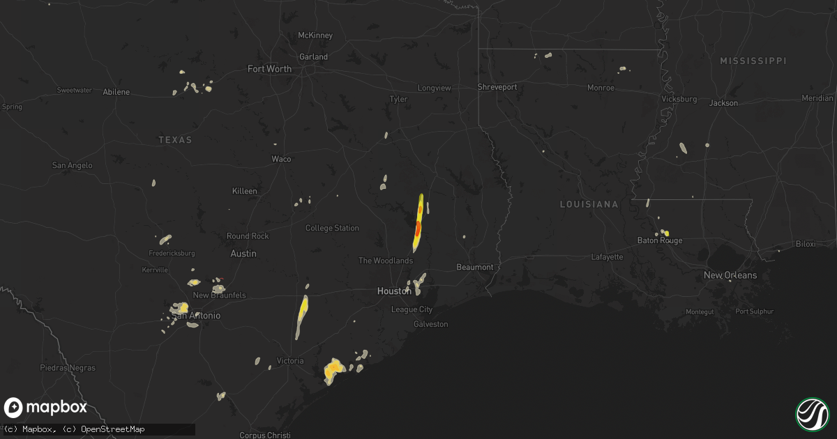
Hail Map on June 11, 2025
Get this storm
June 11 map
$229
one time, instant access
Download today. No call, no setup
Keep the $229
Bought the map and want the full workflow? Apply the entire $229 to a subscription within 7 days. None of it is wasted.
Every map, not just this one
This buys you this map. Subscription and you get every map we run, in the markets you choose from a few cities to whole states to nationwide. Plus real-time alerts the moment a storm fires.
Contact data
Name, contact info, occupancy, even credit band for addresses in the footprint. You go from where it hit to who to call.
Become the source they trust
Unlimited branding weather history reports on demand. You already have the documented answer ready for the property owner, and you are the one who showed up with it.
Property data and RoofTrace estimates
Pull up any address you have got, its value and the exact code rules for that jurisdiction, straight from One Click Code. Then RoofTrace estimates the squares, pitch, and roof value, priced the way you price.
States Impacted by Hail Map on June 11, 2025
Storm reports
Montana
| Date | Description |
|---|---|
| 06/11/20256:25 PM CDT | Mesonet station tt839 quad creek. |
Idaho
| Date | Description |
|---|---|
| 06/11/20254:45 PM CDT | Fish creek summit itd mesonet. |
| 06/11/20254:30 PM CDT | Station canyon pacficorp mesonet on malad summit. |
| 06/11/20254:00 PM CDT | Itd mesonet. |
| 06/11/20253:15 PM CDT | Observed at wfo pocatello. |
| 06/11/20253:10 PM CDT | Power outage in portions of butte county. |
| 06/11/20251:30 PM CDT | Stanley raws. |
Iowa
| Date | Description |
|---|---|
| 06/11/20256:47 PM CDT | Observed 60 mile an hour on anemometer. |
| 06/11/20256:30 PM CDT | Personal weather station. |
| 06/11/20256:30 PM CDT | Personal weather station. (dm |
| 06/11/20256:05 PM CDT | Iowa dot rwis. |
| 06/11/20255:54 PM CDT | Delayed report. Damage to an outbuilding on a farm near dows. Images found via social media. |
| 06/11/20255:39 PM CDT | Awos station kcav clarion airport. |
| 06/11/20255:39 PM CDT | Trees down in belmond. Large branches with trees down to the root. Time estimated from radar. |
| 06/11/20255:39 PM CDT | Corrects previous tstm wnd dmg report from belmond. Small to large tree branches down in belmond. Ti |
| 06/11/20255:39 PM CDT | Corrects previous tstm wnd dmg report from belmond. Small to large tree branches down in belmond. Time estimated from radar. |
| 06/11/20255:20 PM CDT | Personal weather station. |
| 06/11/20255:17 PM CDT | Ping pong size hail south of kanawha at 170th and jackson. |
| 06/11/20255:03 PM CDT | Quarter or a touch bigger hail east of corwith on 150th st. Reported by corwith fire. |
| 06/11/20254:29 PM CDT | Social media picture of medium to large tree branch sent through house roof. Time estimated from radar. |
| 06/11/20254:29 PM CDT | Multiple trees damaged with medium to large limbs down. One tree broken off at the base. One outbuilding damaged. Time estimated from radar. |
| 06/11/20254:27 PM CDT | Measured at algona airport. |
| 06/11/20254:18 PM CDT | From personal weather station. |
| 06/11/20254:04 PM CDT | From personal weather station. |
| 06/11/20253:51 PM CDT | Measured by personal weather station. |
| 06/11/20253:40 PM CDT | Strong wind gusts with large branches down in emmetsburg. |
| 06/11/20253:06 PM CDT | Mesonet station fw7399 terril. |
| 06/11/20253:02 PM CDT | Large tree branch down from 50-60 mph thunderstorm wind gust. Time estimated from radar. |
| 06/11/20252:56 PM CDT | Two trees down along 280th street. |
| 06/11/20252:54 PM CDT | Mostly dime to nickel sized hail... But some as big as a quarter. Briefly heavy rainfall from the thundesrstorm. |
| 06/11/20252:54 PM CDT | Tree damage in the vicinity of 190th avenue and 260th street. Time estimated from radar. |
| 06/11/20252:43 PM CDT | Pea sized hail accompanied 58 mph thunderstorm wind gusts. |
| 06/11/20252:29 PM CDT | Personal weather station reported 60 mph gust. |
| 06/11/20252:23 PM CDT | Estimated wind gust of 60 mph. A lot of blowing dust. |
| 06/11/20252:05 PM CDT | Personal weather station. |
| 06/11/20252:03 PM CDT | 3/4 mile of power poles knocked down by thunderstorm wind gusts. |
| 06/11/20252:01 PM CDT | Lean-to damaged along hwy 9. Time estimated from radar. |
| 06/11/20252:00 PM CDT | Mesonet station rsyi4 sibley. Time estimated from radar. |
| 06/11/20251:56 PM CDT | Roof blown off shed. Time estimated from radar. |
| 06/11/20251:56 PM CDT | Trees reported down in sibley. Time estimated from radar. |
| 06/11/20251:50 PM CDT | Trees are down from thunderstorm wind gusts. Time estimated from radar. |
| 06/11/20251:45 PM CDT | Cattle barn significantly damaged. Time estimated from radar. |
| 06/11/20251:35 PM CDT | Personal weather station. |
| 06/11/20251:35 PM CDT | Machine shed and empty grain bin destroyed. Semi truck tipped. |
| 06/11/20251:31 PM CDT | Roof blown off hog barn. Time estimated from radar. |
| 06/11/20251:31 PM CDT | Personal weather station. |
| 06/11/20251:26 PM CDT | Trees reported down in rock rapids. Time estimated from radar. |
| 06/10/20258:35 PM CDT | Relayed by kcrg tv station. Time estimated using radar. |
| 06/10/20258:33 PM CDT | Estimated 60 mph gust blew over lawn furniture. |
| 06/10/20258:29 PM CDT | Large lighting pole downed at baseball field at fairgrounds. With outflow wind gusts well ahead of storms. |
| 06/10/20258:15 PM CDT | A lot of tree litter being blown around at time of maximum gusts. |
| 06/10/20258:15 PM CDT | Large tree in roadway at 245th st and 260th ave east of delhi. Done by storm outflow winds well ahead of the storms themselves. Time estimated by outflow signature on r |
| 06/10/20258:15 PM CDT | Awos station kvti vinton arpt. |
| 06/10/20258:12 PM CDT | Likely with outflow ahead of the storms. |
| 06/10/20258:12 PM CDT | A few trees snapped and a couple power poles leaning. Damage consistent with gusts greater than 70 mph based on damage and may have peaked 80+ mph. Time estimated using |
| 06/10/20258:08 PM CDT | Large branches down in town. Time estimated using radar. |
| 06/10/20258:00 PM CDT | A local report indicates 63 MPH wind near 1 NNE Aurora |
| 06/10/20257:53 PM CDT | Corrects previous tstm wnd dmg report from 2 se raymond. Delayed report. Semi blown over on highway 20 east of waterloo/southwest of jesup. Time estimated from radar. |
| 06/10/20257:52 PM CDT | Personal weather station. |
| 06/10/20257:50 PM CDT | 60 mph winds and heavy rain in traer area. |
| 06/10/20257:48 PM CDT | Delayed report. Semi blown over on highway 20 east of waterloo. Time and location estimated. |
| 06/10/20257:45 PM CDT | 50 mph winds with 63 mph gusts. 5 mi n of dysart. |
| 06/10/20257:37 PM CDT | Multiple homes damaged by downed tree limbs. Time estimated from radar. |
| 06/10/20257:36 PM CDT | Dime to quarter sized hail covering the ground with strong winds. |
| 06/10/20257:36 PM CDT | Tree on power lines. Power out in portions of cedar falls. |
| 06/10/20257:32 PM CDT | Personal weather station. |
| 06/10/20257:30 PM CDT | Delayed report. Multiple pictures of large tree branches |
| 06/10/20257:28 PM CDT | Tree damage covering road. Small to medium branches. Time estimated from radar. |
| 06/10/20257:28 PM CDT | 60 mph winds in cedar falls. |
| 06/10/20257:28 PM CDT | Various sized branches down across southern portions of of the city. Time estimated by radar. |
| 06/10/20257:28 PM CDT | Personal weather station. |
| 06/10/20257:27 PM CDT | Personal weather station. |
| 06/10/20257:16 PM CDT | Personal weather station. |
| 06/10/20257:08 PM CDT | Personal weather station. |
Wyoming
| Date | Description |
|---|---|
| 06/11/20256:55 PM CDT | Awos station kpna pinedale airport. |
| 06/11/20256:52 PM CDT | A local report indicates 1.50 inch wind near 10 NNE Recluse |
| 06/11/20256:20 PM CDT | Mesonet station pc452 cottonwood merna. |
| 06/11/20256:15 PM CDT | Mesonet station mcobt mount coffin |
| 06/11/20256:10 PM CDT | A local report indicates 1.00 inch wind near 15 NNW Recluse |
| 06/11/20256:10 PM CDT | Mesonet station pc259 wyopo. |
| 06/11/20256:02 PM CDT | Mesonet station krec red canyon - south pass. |
| 06/11/20255:53 PM CDT | Em relayed a report from a resident that strong thunderstorm outflow winds destroyed a gazebo. |
| 06/11/20255:15 PM CDT | Estimated quarter sized hail with very strong winds that bent trees. Unable to leave building to investigate for damage. |
| 06/11/20255:11 PM CDT | Dime to quarter sized hail found 10 to 15 minutes after storm passed. |
| 06/10/20259:46 PM CDT | A local report indicates 65 MPH wind near 17 WSW Wright |
| 06/10/20257:52 PM CDT | Mesonet station khld hiland 2.4 se |
| 06/10/20257:27 PM CDT | A local report indicates 1.25 inch wind near 23 NW Dwtn Gillette |
| 06/10/20257:20 PM CDT | Mesonet station pc456 badwater road. |
| 06/10/20257:00 PM CDT | Mesonet station pc454 moss rock. |
| 06/10/20257:00 PM CDT | Mesonet station pc258 half moon lake. |
South Carolina
| Date | Description |
|---|---|
| 06/11/20254:40 PM CDT | Ping pong ball size hail reported on oakley rd in whitesville. |
| 06/11/20253:28 PM CDT | Photo shared on social media of a tree down across calder road between marion and mullins |
| 06/11/20253:17 PM CDT | Reports of four trees down in and near the city of marion. |
| 06/11/20253:03 PM CDT | Trained spotter reported significant crop damage to a corn field with a photo of all stalks crushed to the ground from a downburst. Also pea sized hail occurred. Time e |
Florida
| Date | Description |
|---|---|
| 06/11/20254:00 PM CDT | Quarter size hail reported in buckingham... Fl. |
| 06/11/20252:25 PM CDT | Caller reported large oak tree branches down on his property near the intersection of west river rd and cheffey rd. |
Texas
| Date | Description |
|---|---|
| 06/11/20253:20 AM CDT | An ef-0 tornado with winds of 75 mph began just east of burr and produced some minor tree damage along its path as it travelled west across cr 117. An older shed also h |
| 06/11/20253:05 AM CDT | An ef-1 tornado with 100 mph winds touched down just behind some apartments northeast of wharton and travelled east across cr 166... Cr 133... And cr 129. The most exte |
| 06/11/20252:25 AM CDT | Widespread tree damage and minor damage to some metal buildings along buffalo road. |
| 06/11/20252:23 AM CDT | Microburst produced a measured wind gust of 95 mph at the palacious airport. Most damage was confined to large tree branches snapped and some minor roof damage in the |
| 06/11/20252:23 AM CDT | Microburst produced a measured wind gust of 95 mph at the palacious airport. Most damage was confined to large tree branches snapped and some minor roof damage in the a |
| 06/11/20252:22 AM CDT | A number of large tree branches down in the area. |
| 06/11/20251:06 AM CDT | Southwest hays county tornado 2 rated ef0. The track of the second tornado was estimated through a combination of information gathered by the survey team and through ra |
| 06/11/20251:04 AM CDT | Damage to trees... Windows... And roof reported. Tornadic debris signature observed on radar. |
| 06/11/20251:02 AM CDT | Southwest hays county tornado 1 rated ef0. The survey team determined that this tornado formed just east of purgatory road... South of farm to market road 32. The most |
| 06/10/202511:42 PM CDT | Estimated 60 mph wind gust and hail up to penny size. |
| 06/10/20257:56 PM CDT | A brief tornado was caught on video west of gholson. Local officials found damage to a property near mary ware dr and hamilton dr. This tornado was rated ef-0 with maxi |
New Mexico
| Date | Description |
|---|---|
| 06/10/20258:53 PM CDT | Asos station krt |
| 06/10/20258:53 PM CDT | Asos station krtn raton crews airport. |
North Carolina
| Date | Description |
|---|---|
| 06/11/20255:10 PM CDT | Tree down. |
| 06/11/20254:49 PM CDT | Large number of power outages due to fallen trees. |
| 06/11/20251:33 PM CDT | The 911 call center reported hail in sunbury. |
Colorado
| Date | Description |
|---|---|
| 06/10/20257:58 PM CDT | Mesonet station up711 7.7 nw boyero |
| 06/10/20257:32 PM CDT | A local report indicates 1.50 inch wind near Wray |
| 06/10/20257:31 PM CDT | A local report indicates 1.50 inch wind near 5 SE Wray |
| 06/10/20257:20 PM CDT | A local report indicates 1.50 inch wind near Wray |
| 06/10/20257:14 PM CDT | Quarter sized hail reported on the east side of wray. |
Louisiana
| Date | Description |
|---|---|
| 06/11/20255:45 PM CDT | Central fire department responded to an uprooted tree from thunderstorm winds near the inters |
| 06/11/20255:45 PM CDT | Central fire department responded to an uprooted tree from thunderstorm winds near the intersection of brown road and comite drive. Report relayed by local broadcast me |
| 06/11/20255:42 PM CDT | Several trees downed in and around the downsville community. |
| 06/11/20255:27 PM CDT | Broadcast media relayed report of quarter sized hail on pheasantwood drive in central this afternoon. Time estimated from radar. |
| 06/11/20254:22 PM CDT | Reports of several trees and powerlines down across the parish. Especially in colfax and montgomery. |
| 06/10/20257:11 PM CDT | Tree down along hwy 582 and another on burrell road. |
| 06/10/20257:02 PM CDT | Tree down along la-577. |
Mississippi
| Date | Description |
|---|---|
| 06/10/20259:20 PM CDT | Several trees were blown down in the georgetown area of e copiah county. One tree was down on a home along ms-hwy 28. |
| 06/10/20259:20 PM CDT | Several trees were blown down in the georgetown area of e copiah county. One tree was down on a home along ms-hwy |
| 06/10/20258:35 PM CDT | A couple trees down. |
Cities Impacted by Hail Map on June 11, 2025
- Emporia, VA
- Jarratt, VA
- Capron, VA
- Yale, VA
- Courtland, VA
- Drewryville, VA
- Franklin, TX
- Crosby, TX
- Branchville, VA
- Suffolk, VA
- Saint Matthews, SC
- Sumter, SC
- Hobbsville, NC
- Gatesville, NC
- Belvidere, NC
- Silsbee, TX
- Sunbury, NC
- Corapeake, NC
- Gates, NC
- Cameron, SC
- Rock Rapids, IA
- Elloree, SC
- Elizabeth City, NC
- South Mills, NC
- George, IA
- Little Rock, IA
- Sibley, IA
- Ocheyedan, IA
- Santee, SC
- Lake Wales, FL
- Leland, NC
- Harris, IA
- Lake Park, IA
- Pelion, SC
- Summerton, SC
- Effingham, SC
- Leesville, SC
- Spirit Lake, IA
- Akron, IA
- Le Mars, IA
- Marion, SC
- Rich Square, NC
- Clewiston, FL
- New Orleans, LA
- Arabi, LA
- Florence, SC
- Harvey, LA
- Malta, ID
- Aulander, NC
- Kelford, NC
- Roxobel, NC
- Marrero, LA
- American Falls, ID
- Pocatello, ID
- Cheyenne, WY
- Tabor City, NC
- Brunsville, IA
- Batesburg, SC
- Okoboji, IA
- Estherville, IA
- Terril, IA
- Superior, IA
- Firth, ID
- Estero, FL
- Naples, FL
- Nunn, CO
- Wagener, SC
- Aiken, SC
- Carpenter, WY
- Lehigh Acres, FL
- Fort Myers, FL
- Holbrook, ID
- Wallingford, IA
- Ault, CO
- Cherokee, IA
- Aurelia, IA
- Holstein, IA
- Wimauma, FL
- Parrish, FL
- Graettinger, IA
- Ringsted, IA
- Cylinder, IA
- Fenton, IA
- Cloudcroft, NM
- Galva, IA
- Alta, IA
- Pocahontas, IA
- Saint Stephen, SC
- Bonneau, SC
- Jamestown, SC
- Nichols, SC
- Green Sea, SC
- Natchez, LA
- Emmetsburg, IA
- Fair Bluff, NC
- Saint George, SC
- North Fort Myers, FL
- Malad City, ID
- Mayhill, NM
- Punta Gorda, FL
- Moncks Corner, SC
- Pinopolis, SC
- Cerro Gordo, NC
- Clayton, ID
- Challis, ID
- Melvin, IA
- Hartley, IA
- Everly, IA
- Milford, IA
- Spencer, IA
- Fostoria, IA
- Dickens, IA
- Arnolds Park, IA
- Ruthven, IA
- Whittemore, IA
- West Bend, IA
- Lone Rock, IA
- Burt, IA
- Algona, IA
- Bladenboro, NC
- Clarkton, NC
- Rolfe, IA
- Tampa, FL
- Aberdeen, ID
- Pingree, ID
- Cape Coral, FL
- Summerville, SC
- Saint George, GA
- Wayan, ID
- Lacrosse, WA
- Lewiston, ID
- Everson, WA
- Nooksack, WA
- Marlin, WA
- Chelan, WA
- Clarkston, WA
- Waterville, WA
- White Bird, ID
- Dayton, WA
- Deming, WA
- Ritzville, WA
- Mccall, ID
- Imnaha, OR
- Asotin, WA
- Lind, WA
- Washtucna, WA
- Rockport, WA
- Cottonwood, ID
- Stanley, ID
- Yellow Pine, ID
- Orondo, WA
- Pomeroy, WA
- Riggins, ID
- Concrete, WA
- Lucile, ID
- Lynden, WA
- Entiat, WA
- Moses Lake, WA
- Anatone, WA
- Soap Lake, WA
- Lu Verne, IA
- Wesley, IA
- Bode, IA
- Bancroft, IA
- Titonka, IA
- Downey, ID
- Gilmore City, IA
- North Port, FL
- Wesley Chapel, FL
- Bradgate, IA
- Baker, LA
- Baton Rouge, LA
- Corwith, IA
- Britt, IA
- Lava Hot Springs, ID
- Autryville, NC
- Roseboro, NC
- Clinton, NC
- Salemburg, NC
- Ottosen, IA
- Folkston, GA
- Lutz, FL
- Kanawha, IA
- Clarion, IA
- Renwick, IA
- Goldfield, IA
- Hardy, IA
- Livermore, IA
- Garner, IA
- Goodell, IA
- Tererro, NM
- Humboldt, IA
- Garland, NC
- Klemme, IA
- Belmond, IA
- Wausa, NE
- Tarboro, NC
- Cross, SC
- North, SC
- Ladson, SC
- Haynesville, LA
- Ridgeville, SC
- Etna, WY
- Harleyville, SC
- Greenwell Springs, LA
- Sheffield, IA
- Rowan, IA
- Latimer, IA
- Meservey, IA
- Alexander, IA
- Hampton, IA
- Coulter, IA
- Dows, IA
- Macclesfield, NC
- Pinetops, NC
- Elm City, NC
- Wilson, NC
- Hartington, NE
- Dorchester, SC
- Galt, IA
- Alden, IA
- Iowa Falls, IA
- Bradford, IA
- Bondurant, WY
- Webster City, IA
- Eagle Grove, IA
- Vincent, IA
- Woolstock, IA
- Yuma, CO
- Williams, IA
- Blairsburg, IA
- Elsmere, NE
- Popejoy, IA
- Geneva, IA
- Ackley, IA
- Aredale, IA
- Greene, IA
- Bristow, IA
- Dumont, IA
- Chapin, IA
- Duncombe, IA
- Fountain, NC
- Haxtun, CO
- Saint Francisville, LA
- Collinston, LA
- Dougherty, IA
- Weston, WY
- Recluse, WY
- Gillette, WY
- Clarksville, IA
- Parkersburg, IA
- Kesley, IA
- Allison, IA
- Aplington, IA
- Austinville, IA
- Shell Rock, IA
- Steamboat Rock, IA
- Wellsburg, IA
- Eldora, IA
- New Roads, LA
- Wray, CO
- Mer Rouge, LA
- Bastrop, LA
- Mount Vernon, SD
- Chappell, NE
- Jackson, LA
- Ireton, IA
- Martin, SC
- Holland, IA
- New Hartford, IA
- Liberty, MS
- Maurice, IA
- Tripoli, IA
- Readlyn, IA
- Sumner, IA
- Morganza, LA
- Caddo, TX
- Ethan, SD
- Kaycee, WY
- Reinbeck, IA
- Fairbank, IA
- Douglas, WY
- Maynard, IA
- Westgate, IA
- Oelwein, IA
- Riverton, WY
- Dike, IA
- Stanley, NM
- Gladbrook, IA
- Holyoke, CO
- Garrett, WY
- Alexandria, SD
- Haigler, NE
- Saint Francis, KS
- Arriba, CO
- Hudson, IA
- Cedar Falls, IA
- Beaman, IA
- Mitchell, SD
- Traer, IA
- Lincoln, IA
- Stout, IA
- Conrad, IA
- Morrison, IA
- Grundy Center, IA
- Dunkerton, IA
- Janesville, IA
- Gilbertville, IA
- Waterloo, IA
- Waverly, IA
- Dewar, IA
- La Porte City, IA
- Jesup, IA
- Buckingham, IA
- Raymond, IA
- Evansdale, IA
- Oran, IA
- Hazleton, IA
- Stanley, IA
- Aurora, IA
- Independence, IA
- Strawberry Point, IA
- Lamont, IA
- Winthrop, IA
- Arlington, IA
- Spencer, SD
- Fayette, IA
- Hugo, CO
- Venango, NE
- Union Church, MS
- Smithville, MO
- Clutier, IA
- Dysart, IA
- Mount Auburn, IA
- Garrison, IA
- Masonville, IA
- Manchester, IA
- Dundee, IA
- Edgewood, IA
- Arthur, NE
- Moriarty, NM
- Waco, TX
- Aquilla, TX
- Crowheart, WY
- Salem, SD
- Big Springs, NE
- Trimble, MO
- Edgerton, MO
- Meadville, MS
- Rowley, IA
- Walker, IA
- Brandon, IA
- Vinton, IA
- Greeley, IA
- Doss, TX
- Estancia, NM
- Fredericksburg, TX
- Mason, TX
- Port Allen, LA
- Urbana, IA
- Center Point, IA
- Toddville, IA
- Shellsburg, IA
- Palo, IA
- Llano, TX
- Van Horne, IA
- Alburnett, IA
- Coggon, IA
- Ryan, IA
- Central City, IA
- Earlville, IA
- Grant, NE
- Bertram, TX
- Wesson, MS
- Buffalo, WY
- Whitman, NE
- Ogallala, NE
- Keystone, NE
- Paxton, NE
- Ranger, TX
- Slaughter, LA
- Ethel, LA
- Rochelle, TX
- Strawn, TX
- Riverside, OR
- Jordan Valley, OR
- Mullen, NE
- Richland Springs, TX
- Santo, TX
- Mingus, TX
- Stephenville, TX
- Boerne, TX
- Kendalia, TX
- Martin, SD
- Gordon, TX
- Adrian, OR
- Prairie City, OR
- Bergheim, TX
- Eastland, TX
- Spring Branch, TX
- Ironside, OR
- Plainfield, IA
- Seneca, NE
- Palisade, NE
- Hyannis, NE
- San Antonio, TX
- Helotes, TX
- Allen, SD
- Hayes Center, NE
- Thedford, NE
- Mico, TX
- Porcupine, SD
- Wanblee, SD
- Rio Medina, TX
- Port O'Connor, TX
- Canyon Lake, TX
- Port Lavaca, TX
- Palacios, TX
- Yoakum, TX
- Wimberley, TX
- San Marcos, TX
- Interior, SD
- Hallettsville, TX
- New Braunfels, TX
- Fischer, TX
- Weimar, TX
- Homer, LA
- Fayetteville, TX
- Hondo, TX
- Castroville, TX
- Ellinger, TX
- Lolita, TX
- Hempstead, TX
- Baytown, TX
- Calvert, TX
- Cameron, TX
- Houston, TX
- Channelview, TX
- La Coste, TX
- Wharton, TX
- Highlands, TX
- Goliad, TX
- Cleveland, TX
- Pasadena, TX
- Shepherd, TX
- Devine, TX
- Palestine, TX
- Jbsa Ft Sam Houston, TX
- Atascosa, TX
- Coldspring, TX
- Goodrich, TX
- Livingston, TX
- Bay City, TX
- Matagorda, TX
- Von Ormy, TX
- Moscow, TX
- Corrigan, TX
- Groveton, TX
- George West, TX
- Crockett, TX
- Lovelady, TX
- Dayton, TX
- Yorktown, TX