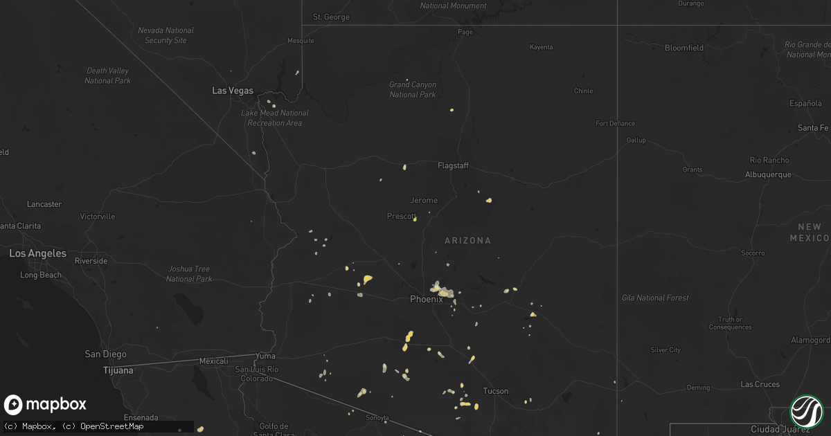
Hail Map on August 12, 2022
Get this storm
August 12 map
$229
one time, instant access
Download today. No call, no setup
Keep the $229
Bought the map and want the full workflow? Apply the entire $229 to a subscription within 7 days. None of it is wasted.
Every map, not just this one
This buys you this map. Subscription and you get every map we run, in the markets you choose from a few cities to whole states to nationwide. Plus real-time alerts the moment a storm fires.
Contact data
Name, contact info, occupancy, even credit band for addresses in the footprint. You go from where it hit to who to call.
Become the source they trust
Unlimited branding weather history reports on demand. You already have the documented answer ready for the property owner, and you are the one who showed up with it.
Property data and RoofTrace estimates
Pull up any address you have got, its value and the exact code rules for that jurisdiction, straight from One Click Code. Then RoofTrace estimates the squares, pitch, and roof value, priced the way you price.
States Impacted by Hail Map on August 12, 2022
Storm reports
Nevada
| Date | Description |
|---|---|
| 08/12/202212:04 AM CDT | At 504 PM MDT, a severe thunderstorm was located near Three Creek, or 21 miles west of Jackpot, moving northeast at 15 mph. HAZARD...60 mph wind gusts and half dollar size hail. SOURCE...Radar indicated. IMPACT...Hail damage to vehicles is expected. Expect wind damage to roofs, siding, and trees. This severe thunderstorm will be near... China Mountain around 530 PM MDT. Cedar Creek Reservoir, Salmon Falls Reservoir and Norton Bay around 540 PM MDT. |
Montana
| Date | Description |
|---|---|
| 08/12/20226:30 PM CDT | Winds are estimated to be from 60 to 70 mph. The time of the event was a guess by the observer. Station elevation: 2306 ft. |
| 08/12/20223:27 AM CDT | At 827 PM MDT, severe thunderstorms were located along a line extending from 22 miles northwest of Havre to 9 miles west of Beaver Creek, moving southeast at 40 mph. HAZARD...60 mph wind gusts. SOURCE...Radar indicated. IMPACT...Expect damage to roofs, siding, and trees. Locations impacted include... Havre, Chinook, Beaver Creek, Lohman, Kremlin and Cleveland. |
| 08/12/20222:36 AM CDT | At 736 PM MDT, severe thunderstorms were located along a line extending from 34 miles north of Gildford to 16 miles north of Inverness, moving east southeast at 35 mph. HAZARD...60 mph wind gusts. SOURCE...Radar indicated. IMPACT...Expect damage to roofs, siding, and trees. Locations impacted include... Havre, Azure, Beaver Creek, Gildford, Sangrey, Boneau, Agency, Parker School, Hingham, Rudyard, Laredo, Kremlin and Simpson. |
| 08/12/20222:13 AM CDT | At 713 PM MDT, severe thunderstorms were located along a line extending from 8 miles northeast of Fairfield to Cascade, moving northeast at 35 mph. HAZARD...60 mph wind gusts. SOURCE...Radar indicated. IMPACT...Expect damage to roofs, siding, and trees. Locations impacted include... Great Falls, Cascade, Dutton, Black Eagle, Fort Shaw, Fort Shaw, Power, Malmstrom Afb, Stockett, Tracy, Vaughn, First Peoples Buffalo Jump State Park, Centerville, Sun River, Ulm and Sand Coulee. |
| 08/12/20221:04 AM CDT | A local report indicates 58 MPH wind near 1 WNW INGOMAR |
| 08/12/202212:32 AM CDT | At 532 PM MDT, a severe thunderstorm was located near North Browning, or 24 miles west of Cut Bank, moving northeast at 25 mph. HAZARD...60 mph wind gusts and quarter size hail. SOURCE...Radar indicated. IMPACT...Hail damage to vehicles is expected. Expect wind damage to roofs, siding, and trees. Locations impacted include... North Browning and South Browning. |
| 08/12/202212:27 AM CDT | At 526 PM MDT, a severe thunderstorm was located over Port Of Morgan, or 20 miles northwest of Whitewater, moving southeast at 25 mph. HAZARD...60 mph wind gusts and quarter size hail. SOURCE...Radar indicated. IMPACT...Hail damage to vehicles is expected. Expect wind damage to roofs, siding, and trees. Locations impacted include... Whitewater, Loring and Port Of Morgan. |
| 08/11/202211:22 PM CDT | At 421 PM MDT, a severe thunderstorm was located 20 miles south of Philipsburg, or 23 miles west of Anaconda, moving northeast at 25 mph. HAZARD...60 mph wind gusts and quarter size hail. SOURCE...Radar indicated. IMPACT...Hail damage to vehicles is expected. Expect wind damage to roofs, siding, and trees. Locations impacted include... Georgetown and Porters Corner. |
| 08/11/202210:45 PM CDT | At 345 PM MDT, a severe thunderstorm was located 16 miles north of North Browning, or 27 miles northwest of Cut Bank, moving east at 15 mph. HAZARD...60 mph wind gusts and quarter size hail. SOURCE...Radar indicated. IMPACT...Hail damage to vehicles is expected. Expect wind damage to roofs, siding, and trees. This severe thunderstorm will remain over mainly rural areas of northeastern Glacier County. |
| 08/11/202210:31 PM CDT | At 330 PM MDT, a severe thunderstorm was located near Superior, moving northeast at 30 mph. HAZARD...60 mph wind gusts and quarter size hail. SOURCE...Radar indicated. IMPACT...Hail damage to vehicles is expected. Expect wind damage to roofs, siding, and trees. Locations impacted include... Camas Prairie and Perma. |
| 08/11/202210:26 PM CDT | At 326 PM MDT, a severe thunderstorm was located near Plains, or 13 miles north of Superior, moving northeast at 25 mph. HAZARD...60 mph wind gusts and nickel size hail. SOURCE...Radar indicated. IMPACT...Expect damage to roofs, siding, and trees. Locations impacted include... Plains, Paradise and Keystone. |
| 08/11/202210:16 PM CDT | At 316 PM MDT, a severe thunderstorm was located 16 miles southeast of Noxon, or 18 miles north of Thompson Falls, moving northeast at 45 mph. HAZARD...60 mph wind gusts and quarter size hail. SOURCE...Radar indicated. IMPACT...Hail damage to vehicles is expected. Expect wind damage to roofs, siding, and trees. Locations impacted include... White Pine, Trout Creek and Happys Inn. |
| 08/11/20229:40 PM CDT | At 240 PM MDT, a severe thunderstorm was located near De Borgia, or 18 miles south of Thompson Falls, moving northeast at 35 mph. HAZARD...60 mph wind gusts and quarter size hail. SOURCE...Radar indicated. IMPACT...Hail damage to vehicles is expected. Expect wind damage to roofs, siding, and trees. Locations impacted include... De Borgia, Haugan and St. Regis. |
| 08/11/20229:13 PM CDT | Corrected for site id. Site kmthavre60. |
| 08/11/20228:33 PM CDT | An ambient weather station measured a 70 mph gust. |
| 08/11/20228:30 PM CDT | Estimated a minimum wind gust of 70 mph. Time was approximated by spotter. |
| 08/11/20228:30 PM CDT | Mesonet station fw1664 hingham. |
| 08/11/20228:15 PM CDT | Reported via facebook. Tree limb knocked down west of the town of vaughn. 6 to 8 inch diameter limb... Estimated from image. |
| 08/11/20228:15 PM CDT | Mesonet station mtm76 cascade e mda. |
| 08/11/20227:37 PM CDT | Ambient sensor measured a 59 mph gust. |
| 08/11/20227:20 PM CDT | Mesonet station mtsbn sieben flats - mdt. |
Arizona
| Date | Description |
|---|---|
| 08/12/20226:40 PM CDT | Power line |
| 08/12/20226:00 PM CDT | Metal power poles blown over trapping 18 vehicles. |
| 08/12/20225:40 PM CDT | Quarter size hail... Timing estimated from radar. |
| 08/12/20225:37 PM CDT | Measured at ksdl... Scottsdale municipal airport. |
| 08/12/20225:22 PM CDT | Power lines down in area. |
| 08/12/20225:05 PM CDT | Corrects previous tstm wnd dmg report from 6 n east mesa. Power lines down in area. |
| 08/12/20224:45 PM CDT | Power lines down in area. |
| 08/12/20222:00 PM CDT | Severe thunderstorm produced 1 inch hail... Heavy rain... And gusty winds peaking at roughly 25 kts. |
| 08/12/20227:36 AM CDT | At 1235 PM MST, a severe thunderstorm was located 9 miles northeast of Starlight Pines, or 25 miles southwest of Winslow, and is nearly stationary. HAZARD...Half dollar size hail. SOURCE...Radar indicated. IMPACT...Damage to vehicles is expected. This severe thunderstorm will remain over mainly rural areas of Coconino County. |
| 08/12/20227:02 AM CDT | At 1201 PM MST, a severe thunderstorm was located 11 miles southeast of Desert View at Grand Canyon, and is nearly stationary. HAZARD...Quarter size hail wind gust up to 40 mph. SOURCE...Radar indicated. IMPACT...Damage to vehicles is expected. This severe thunderstorm will remain over mainly rural areas of Coconino County. |
| 08/12/20226:54 AM CDT | At 1153 AM MST, a severe thunderstorm was located over Dewey-humboldt, or 8 miles southeast of Prescott Valley, and is nearly stationary. HAZARD...60 mph wind gusts and quarter size hail. SOURCE...Radar indicated. IMPACT...Hail damage to vehicles is expected. Expect wind damage to roofs, siding, and trees. Locations impacted include... Dewey-humboldt. |
| 08/12/20226:53 AM CDT | At 1153 AM MST, a severe thunderstorm was located near Three Points, or 19 miles northwest of Green Valley, moving west at 15 mph. HAZARD...60 mph wind gusts and quarter size hail. SOURCE...Radar indicated. IMPACT...Hail damage to vehicles is expected. Expect wind damage to roofs, siding, and trees. Locations impacted include... Three Points. |
| 08/12/20226:51 AM CDT | At 1151 AM MST, a severe thunderstorm was located near Big Horn, or 19 miles southeast of Gila Bend, and is nearly stationary. HAZARD...60 mph wind gusts. SOURCE...Radar indicated. IMPACT...Expect damage to roofs, siding, and trees. Locations impacted include... Estrella, Freeman and Big Horn. This includes the following highways...AZ Interstate 8 between mile markers 128 and 160.AZ Route 238 between mile markers 15 and 24.AZ Route 347 between mile markers 161 and 165. |
| 08/12/20226:39 AM CDT | At 1139 AM MST, a severe thunderstorm was located over Kitt Peak, or 18 miles east of Sells, moving northwest at 5 mph. HAZARD...60 mph wind gusts and nickel size hail. SOURCE...Radar indicated. IMPACT...Expect damage to roofs, siding, and trees. Locations impacted include... San Isidro, Kitt Peak, Fresnal Canyon and Pan Tak. |
| 08/12/20221:41 AM CDT | At 640 PM MST, a severe thunderstorm was located just southeast of Ash Fork, or 27 miles north of Chino Valley, moving south at 10 mph. HAZARD...60 mph wind gusts and half dollar size hail. SOURCE...Radar indicated. IMPACT...Hail damage to vehicles is expected. Expect wind damage to roofs, siding, and trees. This severe thunderstorm will remain over mainly rural areas of Coconino and Yavapai Counties but includes Highway 89 from near Ash Fork south 10 miles. |
| 08/12/202212:30 AM CDT | At 530 PM MST, a severe thunderstorm was located over Tacna, or 26 miles east of Fortuna Foothills, moving north at 5 mph. HAZARD...60 mph wind gusts and penny size hail. SOURCE...Radar indicated. IMPACT...Expect damage to roofs, siding, and trees. Locations impacted include... Tacna, Tyson and Roll. This includes AZ Interstate 8 between mile markers 34 and 48. |
| 08/12/202212:10 AM CDT | At 509 PM MST, a severe thunderstorm was located 16 miles north of Tonopah, moving north at 5 mph. HAZARD...60 mph wind gusts and quarter size hail. SOURCE...Radar indicated. IMPACT...Hail damage to vehicles is expected. Expect wind damage to roofs, siding, and trees. This severe thunderstorm will remain over mainly rural areas of Maricopa County. |
| 08/12/202212:02 AM CDT | At 502 PM MST, a severe thunderstorm was located over Gladden, or 31 miles southeast of Alamo Lake, and is nearly stationary. HAZARD...60 mph wind gusts and penny size hail. SOURCE...Radar indicated. IMPACT...Expect damage to roofs, siding, and trees. Locations impacted include... Wenden, Gladden and Salome. This includes US Highway 60 between mile markers 58 and 81. |
| 08/11/202211:26 PM CDT | At 426 PM MST, a severe thunderstorm was located 11 miles west of Tonopah, moving northwest at 5 mph. HAZARD...60 mph wind gusts and nickel size hail. SOURCE...Radar indicated. IMPACT...Expect damage to roofs, siding, and trees. This severe thunderstorm will remain over mainly rural areas of eastern La Paz and Maricopa Counties.This includes AZ Interstate 10 between mile markers 71 and 92. |
| 08/11/202210:37 PM CDT | At 337 PM MST, severe thunderstorms were located along a line extending from near Scottsdale Airport to near Salt River Indian Community, and are nearly stationary. HAZARD...60 mph wind gusts and quarter size hail. SOURCE...Radar indicated. IMPACT...Hail damage to vehicles is expected. Expect wind damage to roofs, siding, and trees. Locations impacted include... Phoenix, Mesa, Scottsdale, Fountain Hills, Paradise Valley, New River, Cave Creek, Carefree, Piestewa Peak Park, Deer Valley Airport, Granite Reef Dam, Salt River Indian Community, North Mountain Park, Downtown Scottsdale and Scottsdale Airport.This includes the following highways...AZ Interstate 17 between mile markers 214 and 230.AZ Route 51 between mile markers 6 and 15.AZ Route 87 between mile markers 176 and 189. |
| 08/11/202210:18 PM CDT | At 318 PM MST, severe thunderstorms were located along a line extending from Paradise Valley to Salt River Indian Community to Downtown Mesa, moving west at 35 mph. HAZARD...60 mph wind gusts. SOURCE...Radar indicated. IMPACT...Expect damage to roofs, siding, and trees. Locations impacted include... Phoenix, Mesa, Chandler, Glendale, Scottsdale, Gilbert, Tempe, Avondale, Paradise Valley, Tolleson, Laveen, Cashion, Litchfield Park, Tempe Marketplace and Papago Park.This includes the following highways...AZ Interstate 10 between mile markers 129 and 160.AZ Interstate 17 between mile markers 195 and 207.AZ Route 51 between mile markers 1 and 8. |
| 08/11/202210:03 PM CDT | At 303 PM MST, severe thunderstorms were located along a line extending from near Fountain Hills to Granite Reef Dam to near East Mesa, and are nearly stationary. HAZARD...60 mph wind gusts and penny size hail. SOURCE...Radar indicated. IMPACT...Expect damage to roofs, siding, and trees. Locations impacted include... Mesa, Scottsdale, Gilbert, Apache Junction, Fountain Hills, East Mesa, Granite Reef Dam, Falcon Field Airport, McDowell Mountain Park, Usery Mountain Park, Superstition Springs Mall, Goldfield Ranch, Salt River Tubing Recreation Area and Fort McDowell.This includes the following highways...US Highway 60 between mile markers 184 and 192.AZ Route 87 between mile markers 180 and 196.AZ Route 202 between mile markers 15 and 31. |
| 08/11/20229:50 PM CDT | At 250 PM MST, a severe thunderstorm was located 12 miles west of Hilltop, or 14 miles northeast of Globe, moving northwest at 5 mph. HAZARD...60 mph wind gusts and nickel size hail. SOURCE...Radar indicated. IMPACT...Expect damage to roofs, siding, and trees. Locations impacted include... San Carlos.This includes the following highways...US Highway 60 between mile markers 255 and 281.AZ Route 70 between mile markers 261 and 271. |
| 08/11/20229:48 PM CDT | At 248 PM MST, a severe thunderstorm was located 15 miles northeast of Ajo, moving northwest at 10 mph. HAZARD...60 mph wind gusts and penny size hail. SOURCE...Radar indicated. IMPACT...Expect damage to roofs, siding, and trees. This severe thunderstorm will remain over mainly rural areas of Maricopa County.This includes AZ Route 85 between mile markers 13 and 32. |
| 08/11/20229:36 PM CDT | At 236 PM MST, a severe thunderstorm was located near Phoenix Mesa Gateway Airport, or 7 miles southwest of Apache Junction, moving northwest at 5 mph. HAZARD...60 mph wind gusts and penny size hail. SOURCE...Radar indicated. IMPACT...Expect damage to roofs, siding, and trees. Locations impacted include... Mesa, Chandler, Gilbert, Apache Junction, Queen Creek, Chandler Heights, Gilbert City Hall, Chandler City Hall, San Tan Village Mall, San Tan Valley, Seville, Phoenix Mesa Gateway Airport, San Tan Mountain Park, Superstition Springs Mall and Gold Camp.This includes the following highways...US Highway 60 between mile markers 188 and 196.AZ Route 87 near mile marker 166.AZ Route 202 between mile markers 29 and 47. |
| 08/11/20229:31 PM CDT | At 231 PM MST, a severe thunderstorm was located near Hickiwan, or 22 miles east of Ajo, moving west at 15 mph. HAZARD...60 mph wind gusts and quarter size hail. SOURCE...Radar indicated. IMPACT...Hail damage to vehicles is expected. Expect wind damage to roofs, siding, and trees. Locations impacted include... Hickiwan and Vaya Chin. |
| 08/11/20229:11 PM CDT | At 211 PM MST, a severe thunderstorm was located near Canyon Lake, or 13 miles north of Gold Canyon, and is nearly stationary. HAZARD...60 mph wind gusts and penny size hail. SOURCE...Radar indicated. IMPACT...Expect damage to roofs, siding, and trees. Locations impacted include... Sugarloaf Mountain, Saguaro Lake, Canyon Lake and Tortilla Flat. This includes AZ Route 87 between mile markers 197 and 208. |
| 08/11/20229:03 PM CDT | At 203 PM MST, a severe thunderstorm was located over Queen Valley, or 7 miles southeast of Gold Canyon, and is nearly stationary. HAZARD...60 mph wind gusts and penny size hail. SOURCE...Radar indicated. IMPACT...Expect damage to roofs, siding, and trees. Locations impacted include... Apache Junction, Gold Canyon, Florence Junction, Queen Valley, Superstition Mountains, Gold Camp, Kings Ranch, Lost Dutchman State Park and Goldfield.This includes the following highways...US Highway 60 between mile markers 195 and 219.AZ Route 79 between mile markers 148 and 150. |
| 08/11/20228:56 PM CDT | At 156 PM MST, a severe thunderstorm was located over Arizola, or over Casa Grande, and is nearly stationary. HAZARD...60 mph wind gusts and nickel size hail. SOURCE...Radar indicated. IMPACT...Expect damage to roofs, siding, and trees. Locations impacted include... Casa Grande and Arizola. This includes the following highways...AZ Interstate 10 between mile markers 188 and 200.AZ Interstate 8 between mile markers 173 and 178. |
| 08/11/20228:55 PM CDT | At 155 PM MST, a severe thunderstorm was located near Florence, and is nearly stationary. HAZARD...60 mph wind gusts and penny size hail. SOURCE...Radar indicated. IMPACT...Expect damage to roofs, siding, and trees. Locations impacted include... Florence.This includes AZ Route 79 between mile markers 133 and 143. |
| 08/11/20228:53 PM CDT | At 152 PM MST, a severe thunderstorm was located near Camp Creek, or 13 miles west of Sycamore Creek, and is nearly stationary. HAZARD...60 mph wind gusts, penny size hail, and accumulating hail. SOURCE...Radar indicated. IMPACT...Expect damage to roofs, siding, and trees. Locations impacted include... Camp Creek and Horseshoe Reservoir. |
| 08/11/20228:45 PM CDT | At 144 PM PDT/144 PM MST/, a line of severe thunderstorms was located 9 miles west of Temple Bar Campground, or 20 miles east of Boulder City, moving north at 10 mph. HAZARD...40-50 mph gusts at Lake Mead resulting in high crests and hazardous boating conditions. SOURCE...Radar indicated. IMPACT...Expect damage to roofs and trees as well as to small craft. Hazardous boating conditions expected. Locations impacted include... Boulder Beach, Callville Bay Campground, Lake Mead National Recreation Area, Temple Bar Campground, Boulder Beach Campground, Callville Bay, South Cove, Meadview, Hoover Dam and Temple Bar. |
| 08/11/20228:38 PM CDT | At 138 PM MST, a severe thunderstorm was located over Chui-Chu, or 12 miles south of Casa Grande, and is nearly stationary. HAZARD...60 mph wind gusts. SOURCE...Radar indicated. IMPACT...Expect damage to roofs, siding, and trees. Locations impacted include... Casa Grande, Arizona City, Arizola and Toltec. This includes the following highways...AZ Interstate 10 between mile markers 197 and 204.AZ Interstate 8 between mile markers 156 and 178. |
| 08/11/20228:28 PM CDT | At 127 PM MST, a severe thunderstorm was located near Picacho Peak State Park, or 20 miles northwest of Marana, moving northwest at 5 mph. HAZARD...60 mph wind gusts and nickel size hail. SOURCE...Radar indicated. IMPACT...Expect damage to roofs, siding, and trees. Locations impacted include... Eloy, Picacho, Picacho Peak State Park and Red Rock. |
Georgia
| Date | Description |
|---|---|
| 08/12/20227:13 AM CDT | Tree down along asbestos road near helen highway. |
| 08/11/202211:24 PM CDT | At 424 PM EDT, a severe thunderstorm was located over Pineland, moving east at 30 mph. HAZARD...60 mph wind gusts. SOURCE...Radar indicated. IMPACT...Expect damage to trees and powerlines. Locations impacted include: Ridgeland, Yemassee, Furman, Scotia, Coosawhatchie, Tarboro, Grays, Garnett, Pineland, Early Branch, Gillisonville, Robertville and McPhersonville.This warning includes I-95 in South Carolina between mile markers 25and 40. |
Florida
| Date | Description |
|---|---|
| 08/11/20227:55 PM CDT | Delayed report. Trees and power lines down due to strong thunderstorm winds. |
| 08/11/20227:45 PM CDT | Delayed report. Flagler inn hotel sign was blown over from winds. |
North Carolina
| Date | Description |
|---|---|
| 08/12/20225:09 PM CDT | Corrects previous tstm wnd gst report from kclt. Asos station kclt charlotte international airport. |
| 08/12/20225:07 PM CDT | Report of trees down near the vineyards on lake wylie near the charlotte international airport. |
| 08/12/20224:52 PM CDT | 911 call center reported multiple trees and power lines down throughout the city of mount holly. |
| 08/12/20224:34 PM CDT | Tree down on roadway in town of stanley. |
| 08/12/20224:17 PM CDT | Tree down across roadway in the town of vale. |
| 08/12/20224:15 PM CDT | Tree down across roadway in city of lincolnton. |
| 08/12/20224:05 PM CDT | Trees and power lines down in town of stanley. |
| 08/12/20224:05 PM CDT | Tree blocking roadway in the city of maiden. |
| 08/12/20223:48 PM CDT | Powerlines down across roadway in the city of newton. |
| 08/12/20223:37 PM CDT | Multiple reports of trees and power lines down in the city of conover. |
South Carolina
| Date | Description |
|---|---|
| 08/12/20225:45 PM CDT | 911 call center reported power lines and trees down in multiple areas... Especially around tom hall st. |
| 08/12/20225:00 PM CDT | Emergency management reported powerlines and trees down near innsbruck ct and boulder rd. |
| 08/12/20223:24 PM CDT | The south carolina highway patrol reported a tree down due to thunderstorm outflow near the intersection of mewville road and combahee road. |
| 08/12/20221:44 PM CDT | The south carolina highway patrol reported a tree down due to thunderstorm outflow near the intersection of buelah road and lodge highway. |
| 08/12/20221:45 AM CDT | At 644 PM EDT, a severe thunderstorm was located near Fort Mill, or near Indian Land, moving south at 30 mph. HAZARD...60 mph wind gusts and quarter size hail. SOURCE...Radar indicated. IMPACT...Hail damage to vehicles is expected. Expect wind damage to trees and powerlines. Locations impacted include... Lancaster, Elgin, Heath Springs, Andrew Jackson State Park, USC Lancaster, Van Wyck, Irwin, Arrowood Estates, Bell Town Fire Station, Camp Creek Fire Station, Antioch, Kirk Air Base, Faith Christian School, Pleasant Hill, Unity Fire Station, Lancaster Mill, McWhirter Airfield, Bear Creek Park and McDonald Green Elementary School. |
| 08/12/20221:40 AM CDT | At 640 PM EDT, a severe thunderstorm was located 4 miles southwest of Indian Land, moving south at 30 mph. HAZARD...60 mph wind gusts. SOURCE...Radar indicated. IMPACT...Expect damage to trees and power lines. Locations impacted include... Lesslie, Great Falls, Marvin, Fort Lawn, Catawba, Jaars, Carolina Commons Shopping Center, Fishing Creek Reservoir, Rock Hill and Edgemoor. |
| 08/12/20221:15 AM CDT | At 615 PM EDT, a severe thunderstorm was located over Southwest Charlotte, or near Uptown Charlotte, moving south at 35 mph. HAZARD...60 mph wind gusts. SOURCE...Radar indicated. IMPACT...Expect damage to trees and powerlines. Locations impacted include... Indian Land, Carolina Commons Shopping Center and Community of Almond Glen. |
| 08/12/20221:12 AM CDT | At 612 PM EDT, a severe thunderstorm was located 6 miles southwest of Uptown Charlotte, or near Southwest Charlotte, moving south at 25 mph. HAZARD...60 mph wind gusts and penny size hail. SOURCE...Radar indicated. IMPACT...Expect damage to trees and power lines. Locations impacted include... Uptown Charlotte, Central Charlotte, South Charlotte, Southwest Charlotte, Weddington, Fort Mill, Pineville, Tega Cay, Wesley Chapel and Lesslie. |
| 08/12/202212:43 AM CDT | At 542 PM EDT, a severe thunderstorm was located 8 miles southwest of Huntersville, or 4 miles northeast of Mt Holly, moving southeast at 25 mph. HAZARD...60 mph wind gusts and penny size hail. SOURCE...Radar indicated. IMPACT...Expect damage to trees and power lines. Locations impacted include... Uptown Charlotte, Central Charlotte, Northeast Charlotte, Southwest Charlotte, East Charlotte, Northwest Charlotte, Mt Holly, Belmont, Stanley and Cramerton. |
Oregon
| Date | Description |
|---|---|
| 08/12/20223:20 PM CDT | Via social media. Time estimated from radar. |
| 08/11/20229:30 PM CDT | At 230 PM MDT/130 PM PDT/, a severe thunderstorm was located over Cuprum, or 32 miles west of McCall, moving northeast at 50 mph. HAZARD...Half dollar size hail. SOURCE...Radar indicated. IMPACT...Damage to vehicles is expected. This severe thunderstorm will be near... Black Lake and Pollock Mountain around 250 PM MDT. |
| 08/11/20229:08 PM CDT | At 208 PM PDT, a severe thunderstorm was located 8 miles southwest of Riggins, or 35 miles northwest of McCall, moving northeast at 40 mph. HAZARD...60 mph wind gusts and half dollar size hail. SOURCE...Radar indicated. IMPACT...Hail damage to vehicles is expected. Expect wind damage to roofs, siding, and trees. Locations impacted include... Riggins, Pollock, Slate Creek, Riggins Hot Spring and Lucile. |
| 08/11/20229:02 PM CDT | At 201 PM MDT/101 PM PDT/, a severe thunderstorm was located near Brownlee Dam, or 39 miles southeast of Enterprise, moving northeast at 75 mph. HAZARD...60 mph wind gusts and quarter size hail. SOURCE...Radar indicated. IMPACT...Hail damage to vehicles is expected. Expect wind damage to roofs, siding, and trees. This severe thunderstorm will be near... Bear around 210 PM MDT. Cuprum and Black Lake around 220 PM MDT. Pollock Mountain around 230 PM MDT. |
Washington
| Date | Description |
|---|---|
| 08/12/202211:15 AM CDT | A local report indicates 1.00 inch wind near 7 ENE LIND |
| 08/12/202211:09 AM CDT | Twitter report. |
| 08/12/202210:30 AM CDT | Picture report from facebook. |
| 08/12/20223:46 AM CDT | At 846 AM PDT, a severe thunderstorm was located 10 miles north of Kahlotus, or 12 miles northeast of Connell, moving north at 25 mph. HAZARD...Half dollar size hail. SOURCE...Radar indicated. IMPACT...Damage to vehicles is expected. Locations impacted include... Lind, Ralston, Pizzro and Paha. This includes Interstate 90 in Washington between mile markers 208and 218. |
| 08/12/20223:29 AM CDT | At 829 AM PDT, a severe thunderstorm was located 14 miles southeast of Cheney, moving northeast at 30 mph. HAZARD...Half dollar size hail. SOURCE...Radar indicated. IMPACT...Damage to vehicles is expected. Locations impacted include... Rockford, Spangle, Plaza, Mica and Valleyford. |
Texas
| Date | Description |
|---|---|
| 08/12/20223:30 PM CDT | Estimated wind 50 mph. Metal roofs pulled back and some siding ripped off dilapidated buildings. Minor damage to scalfolding and cinder block walls under construction a |
Idaho
| Date | Description |
|---|---|
| 08/12/20226:00 PM CDT | Spotter reported isolated golf ball size hail dropping out of passing thunderstorm. |
| 08/12/20225:00 PM CDT | Via social media. Time is approximate. |
| 08/12/20224:24 PM CDT | Tree was reportedly down near mile markers 143 and 144 on us-12. |
| 08/12/20224:20 PM CDT | Hail between quarter and half dollar size reported from salmon rapids lodge. Lots of leaves down but no other observed damage at this time. |
| 08/12/20224:20 PM CDT | Hail between quarter and half dollar size reported from salmon rapids lodge. Lots of le |
| 08/12/20223:39 PM CDT | Hail ranging from quarter to ping pong. Via social media. |
| 08/12/20222:52 PM CDT | Strong thunderstorm winds estimated near 60 mph. Half inch hail also fell with the storm. |
| 08/12/20227:52 AM CDT | At 1252 PM PDT, severe thunderstorms were located along a line extending from 8 miles east of Culdesac to 14 miles south of Craigmont, moving northeast at 45 mph. HAZARD...60 mph wind gusts and half dollar size hail. SOURCE...Radar indicated. IMPACT...Hail damage to vehicles is expected. Expect wind damage to roofs, siding, and trees. Locations impacted include... Kamiah, Craigmont, Nezperce, Winchester, Peck, Reubens, Mohler and Gifford.This includes the following highways... U.S. Highway 95 in Idaho between mile markers 268 and 288. U.S. Highway 12 in Idaho between mile markers 32 and 34, betweenmile markers 52 and 54, and between mile markers 59 and 67. |
| 08/12/20227:51 AM CDT | At 1251 PM MDT, a severe thunderstorm was located near Council Mountain, or 9 miles southwest of McCall, moving northeast at 40 mph. HAZARD...60 mph wind gusts and half dollar size hail. SOURCE...Radar indicated. IMPACT...Hail damage to vehicles is expected. Expect wind damage to roofs, siding, and trees. This severe thunderstorm will be near... McCall around 100 PM MDT. Payette Lake, Little Payette Lake and Lake Fork Guard Station around 110 PM MDT. Lick Creek Summit around 120 PM MDT. Ponderosa Campground and Upper Payette Lake around 130 PM MDT. |
| 08/12/20221:11 AM CDT | At 611 PM MDT, a severe thunderstorm was located over Monumental Peak, or 25 miles north of Lowman, moving north at 20 mph. HAZARD...Ping pong ball size hail and 60 mph wind gusts. SOURCE...Radar indicated. IMPACT...People and animals outdoors will be injured. Expect hail damage to roofs, siding, windows, and vehicles. Expect wind damage to roofs, siding, and trees. This severe thunderstorm will be near... Deadwood Summit around 630 PM MDT. Warm Lake and Big Creek Summit around 650 PM MDT. Landmark around 700 PM MDT. |
| 08/12/202212:32 AM CDT | At 531 PM MDT, a severe thunderstorm was located near Deadwood Reservoir, or 11 miles north of Lowman, moving northeast at 50 mph. HAZARD...Ping pong ball size hail and 60 mph wind gusts. SOURCE...Radar indicated. IMPACT...People and animals outdoors will be injured. Expect hail damage to roofs, siding, windows, and vehicles. Expect wind damage to roofs, siding, and trees. This severe thunderstorm will be near... Deer Creek Pass, Bear Valley Campground and Monumental Peak around 550 PM MDT. Sulphur Creek Ranch and Deadwood Summit around 600 PM MDT. Boundary Creek Launch Site, Dagger Falls and Landmark around 610 PM MDT. |
| 08/11/202211:28 PM CDT | At 428 PM MDT, a severe thunderstorm was located near Deadwood Summit, or 28 miles north of Lowman, moving northeast at 40 mph. HAZARD...Half dollar size hail. SOURCE...Radar indicated. IMPACT...Damage to vehicles is expected. This severe thunderstorm will be near... Deadwood Summit around 430 PM MDT. Landmark, Sulphur Creek Ranch and Warm Lake around 440 PM MDT. Halfway Station around 450 PM MDT. Pistol Rock around 500 PM MDT. |
| 08/11/202211:21 PM CDT | At 421 PM MDT, a severe thunderstorm was located near Crows Nest Butte, or 19 miles south of Glenns Ferry, moving north at 20 mph. HAZARD...60 mph wind gusts and half dollar size hail. SOURCE...Radar indicated. IMPACT...Hail damage to vehicles is expected. Expect wind damage to roofs, siding, and trees. This severe thunderstorm will be near... Deadman Flat around 450 PM MDT. Twentymile Butte around 500 PM MDT. |
| 08/11/202211:13 PM CDT | At 413 PM MDT, a severe thunderstorm was located over Lucky Peak Reservoir, or 14 miles east of Boise, moving northeast at 25 mph. HAZARD...Ping pong ball size hail and 60 mph wind gusts. SOURCE...Radar indicated. IMPACT...People and animals outdoors will be injured. Expect hail damage to roofs, siding, windows, and vehicles. Expect wind damage to roofs, siding, and trees. This severe thunderstorm will be near... Arrowrock Dam around 420 PM MDT. Arrowrock Reservoir and Twin Springs around 440 PM MDT. Thorn Creek Summit around 450 PM MDT. Idaho City, Barber Flat Guard Station and Harris Creek Summit around 500 PM MDT. |
| 08/11/202211:12 PM CDT | At 411 PM MDT, a severe thunderstorm was located near Big Foot Butte, or 27 miles west of Mountain Home, moving north at 35 mph. HAZARD...Half dollar size hail. SOURCE...Radar indicated. IMPACT...Damage to vehicles is expected. This severe thunderstorm will be near... Big Foot Butte around 420 PM MDT. Swan Falls around 430 PM MDT. Initial Point around 440 PM MDT. |
| 08/11/202211:03 PM CDT | At 403 PM MDT, a severe thunderstorm was located near Crows Nest Butte, or 24 miles south of Glenns Ferry, moving north at 20 mph. HAZARD...Ping pong ball size hail and 60 mph wind gusts. SOURCE...Radar indicated. IMPACT...People and animals outdoors will be injured. Expect hail damage to roofs, siding, windows, and vehicles. Expect wind damage to roofs, siding, and trees. This severe thunderstorm will remain over mainly rural areas of south central Elmore and east central Owyhee Counties. |
| 08/11/202211:02 PM CDT | At 402 PM MDT, a severe thunderstorm was located near Deadwood Summit, or 29 miles north of Lowman, moving north at 25 mph. HAZARD...Quarter size hail. SOURCE...Radar indicated. IMPACT...Damage to vehicles is expected. This severe thunderstorm will be near... Sulphur Creek Ranch and Boundary Creek Launch Site around 410 PM MDT. Landmark around 430 PM MDT. |
| 08/11/202210:48 PM CDT | At 348 PM MDT, a severe thunderstorm was located near Twin Springs, or 15 miles south of Idaho City, moving north at 35 mph. HAZARD...Quarter size hail. SOURCE...Radar indicated. IMPACT...Damage to vehicles is expected. This severe thunderstorm will be near... Thorn Creek Summit and Twin Springs around 400 PM MDT. Idaho City, Barber Flat Guard Station and Dutch Creek Guard Station around 410 PM MDT. |
| 08/11/202210:46 PM CDT | At 346 PM MDT, a severe thunderstorm was located over Lucky Peak Dam, or 12 miles southeast of Boise, moving north at 40 mph. HAZARD...60 mph wind gusts and half dollar size hail. SOURCE...Radar indicated. IMPACT...Hail damage to vehicles is expected. Expect wind damage to roofs, siding, and trees. This severe thunderstorm will be near... Lucky Peak Reservoir, Arrowrock Dam, Lucky Peak Spring Shores Marina and Aldape Summit around 400 PM MDT. Arrowrock Reservoir around 410 PM MDT. |
| 08/11/202210:11 PM CDT | At 311 PM MDT, a severe thunderstorm was located 7 miles east of Mores Creek Summit, or 8 miles southeast of Lowman, moving northeast at 30 mph. HAZARD...Quarter size hail. SOURCE...Radar indicated. IMPACT...Damage to vehicles is expected. This severe thunderstorm will be near... Graham Guard Station around 320 PM MDT. Helende Campground around 330 PM MDT. Warm Springs Guard Station around 340 PM MDT. |
| 08/11/202210:07 PM CDT | At 306 PM PDT, a severe thunderstorm was located 21 miles southeast of Grangeville, moving northeast at 45 mph. HAZARD...Golf ball size hail and 60 mph wind gusts. SOURCE...Radar indicated. IMPACT...People and animals outdoors will be injured. Expect hail damage to roofs, siding, windows, and vehicles. Expect wind damage to roofs, siding, and trees. Locations impacted include... Red River Hot Spring, Orogrande, Elk City, Fall Creek, Newsome and Golden. |
| 08/11/20229:45 PM CDT | At 245 PM PDT, a severe thunderstorm was located 19 miles southeast of White Bird, or 23 miles south of Grangeville, moving northeast at 45 mph. HAZARD...Two inch hail and 70 mph wind gusts. SOURCE...Radar indicated. IMPACT...People and animals outdoors will be injured. Expect hail damage to roofs, siding, windows, and vehicles. Expect considerable tree damage. Wind damage is also likely to mobile homes, roofs, and outbuildings. This severe thunderstorm will remain over mainly rural areas of south central Idaho County. |
| 08/11/20229:39 PM CDT | At 239 PM MDT, a severe thunderstorm was located near C J Strike Reservoir, or 13 miles south of Mountain Home, moving north at 45 mph. HAZARD...60 mph wind gusts and quarter size hail. SOURCE...Radar indicated. IMPACT...Hail damage to vehicles is expected. Expect wind damage to roofs, siding, and trees. Brief heavy rains are also expected. This severe thunderstorm will be near... Mountain Home Air Force Base around 250 PM MDT. Mountain Home and Cinder Cone Butte around 300 PM MDT. Tollgate around 310 PM MDT. |
| 08/11/20229:22 PM CDT | At 221 PM PDT, a severe thunderstorm was located 33 miles northeast of Lowell, or 45 miles west of Hamilton, moving northeast at 35 mph. HAZARD...60 mph wind gusts. SOURCE...Radar indicated. IMPACT...Expect damage to roofs, siding, and trees. Locations impacted include... Powell and Highway 12 |
| 08/11/20228:58 PM CDT | At 158 PM MDT, severe thunderstorms were located along a line extending from near Bruneau Canyon Viewpoint to 6 miles north of Gedney Butte, moving northwest at 10 mph. HAZARD...60 mph wind gusts and quarter size hail. Brief heavy rainfall is expected. SOURCE...Radar indicated. IMPACT...Hail damage to vehicles is expected. Expect wind damage to roofs, siding, and trees. Severe thunderstorms will be near... Hot Spring around 230 PM MDT. Mountain Home, Bruneau, Mountain Home Air Force Base and Grand View around 240 PM MDT. |
| 08/11/20228:54 PM CDT | At 154 PM PDT, a severe thunderstorm was located 13 miles northeast of Lowell, or 29 miles east of Kamiah, moving northeast at 25 mph. HAZARD...60 mph wind gusts and quarter size hail. SOURCE...Radar indicated. IMPACT...Hail damage to vehicles is expected. Expect wind damage to roofs, siding, and trees. Trees could fall onto Highway 12. This severe thunderstorm will remain over mainly rural areas of north central Idaho County. |
| 08/11/20228:08 PM CDT | At 107 PM PDT, a severe thunderstorm was located 8 miles southwest of Orofino, moving northeast at 45 mph. HAZARD...60 mph wind gusts and quarter size hail. SOURCE...Radar indicated. IMPACT...Hail damage to vehicles is expected. Expect wind damage to roofs, siding, and trees. Locations impacted include... Orofino, Elk River, Headquarters, Ahsahka, Dent, Greer, Teakean, Riverside and Cardiff. |
Cities Impacted by Hail Map on August 12, 2022
- Heart Butte, MT
- Craigmont, ID
- Cottonwood, ID
- Harrington, WA
- Oneill, NE
- Emmet, NE
- Lind, WA
- Ogden, UT
- Ritzville, WA
- Wickenburg, AZ
- Oroville, WA
- Trout Creek, MT
- Thompson Falls, MT
- Canton, MN
- Mabel, MN
- Dorchester, IA
- Decorah, IA
- Spring Grove, MN
- Mountain Home, ID
- Bruneau, ID
- Murphy, ID
- Judith Gap, MT
- Shawmut, MT
- Pendroy, MT
- Florence, AZ
- Garden Valley, ID
- Mccall, ID
- Cascade, ID
- Sedona, AZ
- Elma, IA
- Riceville, IA
- Verdigre, NE
- Imnaha, OR
- Lima, MT
- Halfway, OR
- Council, ID
- Oxbow, OR
- Cascade, MT
- Niobrara, NE
- Cambridge, ID
- Philipsburg, MT
- Fort Mill, SC
- Connell, WA
- Elk City, ID
- Rosalia, WA
- Spangle, WA
- Tucson, AZ
- Humboldt, AZ
- Dewey, AZ
- Scottsdale, AZ
- Bosler, WY
- Grand View, ID
- Sanford, FL
- Lake Mary, FL
- Paradise Valley, AZ
- Boise, ID
- Indian Valley, ID
- Lucile, ID
- Riggins, ID
- Loring, MT
- Bingham Canyon, UT
- West Jordan, UT
- Whitewater, MT
- Stuart, NE
- Mesa, AZ
- Mountain Home Afb, ID
- Atkinson, NE
- Fountain Hills, AZ
- Fort Mcdowell, AZ
- Phoenix, AZ
- Sells, AZ
- Shiner, TX
- Enterprise, OR
- Mesa, ID
- Superior, AZ
- Maricopa, AZ
- Tonopah, AZ
- Queen Creek, AZ
- Louise, TX
- Apache Junction, AZ
- Lynch, NE
- King Hill, ID
- Yellow Pine, ID
- Fairfield, WA
- Charlotte, NC