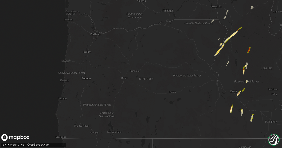
Hail Map in Oregon on August 12, 2022
Get this storm
August 12 map
$229
one time, instant access
Download today. No call, no setup
Keep the $229
Bought the map and want the full workflow? Apply the entire $229 to a subscription within 7 days. None of it is wasted.
Every map, not just this one
This buys you this map. Subscription and you get every map we run, in the markets you choose from a few cities to whole states to nationwide. Plus real-time alerts the moment a storm fires.
Contact data
Name, contact info, occupancy, even credit band for addresses in the footprint. You go from where it hit to who to call.
Become the source they trust
Unlimited branding weather history reports on demand. You already have the documented answer ready for the property owner, and you are the one who showed up with it.
Property data and RoofTrace estimates
Pull up any address you have got, its value and the exact code rules for that jurisdiction, straight from One Click Code. Then RoofTrace estimates the squares, pitch, and roof value, priced the way you price.
Storm reports in Oregon
Oregon
| Date | Description |
|---|---|
| 08/12/20223:20 PM CDT | Via social media. Time estimated from radar. |
| 08/11/20229:30 PM CDT | At 230 PM MDT/130 PM PDT/, a severe thunderstorm was located over Cuprum, or 32 miles west of McCall, moving northeast at 50 mph. HAZARD...Half dollar size hail. SOURCE...Radar indicated. IMPACT...Damage to vehicles is expected. This severe thunderstorm will be near... Black Lake and Pollock Mountain around 250 PM MDT. |
| 08/11/20229:08 PM CDT | At 208 PM PDT, a severe thunderstorm was located 8 miles southwest of Riggins, or 35 miles northwest of McCall, moving northeast at 40 mph. HAZARD...60 mph wind gusts and half dollar size hail. SOURCE...Radar indicated. IMPACT...Hail damage to vehicles is expected. Expect wind damage to roofs, siding, and trees. Locations impacted include... Riggins, Pollock, Slate Creek, Riggins Hot Spring and Lucile. |
| 08/11/20229:02 PM CDT | At 201 PM MDT/101 PM PDT/, a severe thunderstorm was located near Brownlee Dam, or 39 miles southeast of Enterprise, moving northeast at 75 mph. HAZARD...60 mph wind gusts and quarter size hail. SOURCE...Radar indicated. IMPACT...Hail damage to vehicles is expected. Expect wind damage to roofs, siding, and trees. This severe thunderstorm will be near... Bear around 210 PM MDT. Cuprum and Black Lake around 220 PM MDT. Pollock Mountain around 230 PM MDT. |
All States Impacted by Hail Map on August 12, 2022
Cities Impacted by Hail Map on August 12, 2022
- Heart Butte, MT
- Craigmont, ID
- Cottonwood, ID
- Harrington, WA
- Oneill, NE
- Emmet, NE
- Lind, WA
- Ogden, UT
- Ritzville, WA
- Wickenburg, AZ
- Oroville, WA
- Trout Creek, MT
- Thompson Falls, MT
- Canton, MN
- Mabel, MN
- Dorchester, IA
- Decorah, IA
- Spring Grove, MN
- Mountain Home, ID
- Bruneau, ID
- Murphy, ID
- Judith Gap, MT
- Shawmut, MT
- Pendroy, MT
- Florence, AZ
- Garden Valley, ID
- Mccall, ID
- Cascade, ID
- Sedona, AZ
- Elma, IA
- Riceville, IA
- Verdigre, NE
- Imnaha, OR
- Lima, MT
- Halfway, OR
- Council, ID
- Oxbow, OR
- Cascade, MT
- Niobrara, NE
- Cambridge, ID
- Philipsburg, MT
- Fort Mill, SC
- Connell, WA
- Elk City, ID
- Rosalia, WA
- Spangle, WA
- Tucson, AZ
- Humboldt, AZ
- Dewey, AZ
- Scottsdale, AZ
- Bosler, WY
- Grand View, ID
- Sanford, FL
- Lake Mary, FL
- Paradise Valley, AZ
- Boise, ID
- Indian Valley, ID
- Lucile, ID
- Riggins, ID
- Loring, MT
- Bingham Canyon, UT
- West Jordan, UT
- Whitewater, MT
- Stuart, NE
- Mesa, AZ
- Mountain Home Afb, ID
- Atkinson, NE
- Fountain Hills, AZ
- Fort Mcdowell, AZ
- Phoenix, AZ
- Sells, AZ
- Shiner, TX
- Enterprise, OR
- Mesa, ID
- Superior, AZ
- Maricopa, AZ
- Tonopah, AZ
- Queen Creek, AZ
- Louise, TX
- Apache Junction, AZ
- Lynch, NE
- King Hill, ID
- Yellow Pine, ID
- Fairfield, WA
- Charlotte, NC


