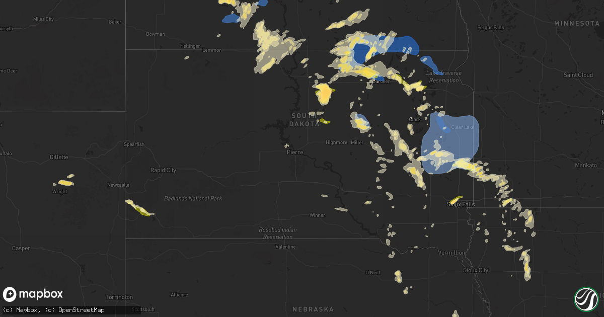
Hail Map in South Dakota on August 5, 2025
Get this storm
August 5 map
$229
one time, instant access
Download today. No call, no setup
Keep the $229
Bought the map and want the full workflow? Apply the entire $229 to a subscription within 7 days. None of it is wasted.
Every map, not just this one
This buys you this map. Subscription and you get every map we run, in the markets you choose from a few cities to whole states to nationwide. Plus real-time alerts the moment a storm fires.
Contact data
Name, contact info, occupancy, even credit band for addresses in the footprint. You go from where it hit to who to call.
Become the source they trust
Unlimited branding weather history reports on demand. You already have the documented answer ready for the property owner, and you are the one who showed up with it.
Property data and RoofTrace estimates
Pull up any address you have got, its value and the exact code rules for that jurisdiction, straight from One Click Code. Then RoofTrace estimates the squares, pitch, and roof value, priced the way you price.
Storm reports in South Dakota
South Dakota
| Date | Description |
|---|---|
| 08/05/20256:44 PM CDT | Estimated 50 to 60 mph winds. |
| 08/05/20254:39 PM CDT | Report from mping: ping pong ball |
| 08/05/20254:34 PM CDT | Quarter size hail reported in elm lake. Time estimated by radar. |
| 08/05/202512:05 AM CDT | Large tree branch down along faculty drive. Time estimated from radar. |
| 08/05/202512:04 AM CDT | Estimated winds. Trees bent over and fallen branches |
| 08/05/202512:04 AM CDT | Estimated winds. Trees bent over and fallen branches. |
| 08/05/202512:01 AM CDT | Mesonet station 312 ree heights |
| 08/05/202512:00 AM CDT | Minor tree damage in huron with one tree that fell on a garage. Time estimated from radar. |
| 08/04/202511:57 PM CDT | Personal weather station. |
| 08/04/202511:35 PM CDT | Mesonet station 262 4w bryant |
| 08/04/202511:03 PM CDT | Multiple trees were snapped at the top in town and there was an empty grain bin blown open near town. |
| 08/04/202510:56 PM CDT | Numerous tree branches blown at least 90 feet into a field. The largest branches knocked down were around 6 inches in diameter. |
| 08/04/202510:55 PM CDT | Two hay bales rolled over 100 ft across a field. |
| 08/04/202510:52 PM CDT | Mesonet station 224 sd rwis ward. |
| 08/04/202510:50 PM CDT | Asos station katy watertown muni ap. |
| 08/04/202510:50 PM CDT | Multiple uprooted trees up along kampeska. Time radar estimated. |
| 08/04/202510:49 PM CDT | Personal weather station peak gust. |
| 08/04/202510:47 PM CDT | Images of a tree uprooted sent via facebook. Tree fell onto a garage and caused some damage to the building. Time estimated by radar. |
| 08/04/202510:44 PM CDT | Mesonet station 158 miranda |
| 08/04/202510:35 PM CDT | Social media picture. |
| 08/04/202510:34 PM CDT | A local report indicates 1.00 inch wind near 6 SW Aurora |
| 08/04/202510:32 PM CDT | A local report indicates 1.75 inch wind near 1 N Wall Lake |
| 08/04/20259:45 PM CDT | Hail size estimated by observer and the hail caused some minor damage to their corn crop. |
| 08/04/20259:45 PM CDT | Hay bales tossed from north to south across the highway. Radar estimated time. |
| 08/04/20259:20 PM CDT | Corrects previous hail report from 4 ene hoven. |
| 08/04/20259:20 PM CDT | Estimated 60 mph winds and small branches broke off of trees. Radar estimated time. |
| 08/04/20259:20 PM CDT | Photo send via social media. |
| 08/04/20259:15 PM CDT | Personal weather station. |
| 08/04/20259:05 PM CDT | Multiple large tree branches down at lee park golf course. |
| 08/04/20259:00 PM CDT | A local report indicates 1.75 inch wind near 10 S Bowdle |
| 08/04/20258:50 PM CDT | Mesonet station 2 lake city |
| 08/04/20258:50 PM CDT | Penny to quarter size hail. |
| 08/04/20258:40 PM CDT | Mesonet station mrls2 hillhead 3 wsw. Radar estimated time. |
| 08/04/20258:37 PM CDT | A local report indicates 1.50 inch wind near Wetonka |
| 08/04/20258:20 PM CDT | A local report indicates 1.00 inch wind near 4 ENE Hoven |
| 08/04/20258:15 PM CDT | Golf ball to baseball size hail reported. |
| 08/04/20257:54 PM CDT | Preliminary information. Location estimated by report and radar. |
| 08/04/20257:48 PM CDT | A local report indicates 1.50 inch wind near 5 W Webster |
| 08/04/20257:20 PM CDT | Estimated pea to quarter size hail for 30 minutes to an hour. Measured 3.5 inches of rainfall. Some crop and garden damage from the hail. |
| 08/04/20257:00 PM CDT | Dime to quarter |
All States Impacted by Hail Map on August 5, 2025
Cities Impacted by Hail Map on August 5, 2025
- Harrison, NE
- Stratton, CO
- Burlington, CO
- Bethune, CO
- New Leipzig, ND
- Glen Ullin, ND
- Killdeer, ND
- Maywood, NE
- Curtis, NE
- North Platte, NE
- Elgin, ND
- Maxwell, NE
- Wellfleet, NE
- Almont, ND
- Indianola, NE
- Bartley, NE
- Moorefield, NE
- Brady, NE
- Hettinger, ND
- Flasher, ND
- Carson, ND
- Stockville, NE
- Davis, OK
- Lodgepole, SD
- Shields, ND
- Selfridge, ND
- McLaughlin, SD
- Farnam, NE
- Raleigh, ND
- Mandan, ND
- Solen, ND
- New Salem, ND
- Saint Anthony, ND
- Bullhead, SD
- Fort Yates, ND
- Wakpala, SD
- Strasburg, ND
- Linton, ND
- Arapahoe, NE
- Pollock, SD
- Mound City, SD
- Herreid, SD
- Hague, ND
- Center, ND
- Wilton, ND
- Jacksonville, FL
- Washburn, ND
- Jesup, GA
- Regan, ND
- Mercer, ND
- Labadieville, LA
- Thibodaux, LA
- Loxahatchee, FL
- Mcclusky, ND
- Fort Stewart, GA
- Steele, ND
- Dawson, ND
- Ishpeming, MI
- Robinson, ND
- Tappen, ND
- Savannah, GA
- Bloomingdale, GA
- Pooler, GA
- Port Wentworth, GA
- Rincon, GA
- Lehr, ND
- Streeter, ND
- Leola, SD
- Westport, SD
- Campo, CO
- Wishek, ND
- Pettibone, ND
- Medina, ND
- Long Lake, SD
- Barnard, SD
- Gackle, ND
- Fredonia, ND
- Ashley, ND
- Frederick, SD
- Ellendale, ND
- Kulm, ND
- Edgeley, ND
- Jud, ND
- Ariton, AL
- Pierson, FL
- Bunnell, FL
- De Leon Springs, FL
- Oakes, ND
- Gillette, WY
- Woodworth, ND
- Forbes, ND
- Deland, FL
- Orlando, FL
- Fullerton, ND
- Maitland, FL
- Winter Park, FL
- Casselberry, FL
- Edgemont, SD
- Eureka, SD
- Lake Helen, FL
- Cleveland, ND
- Pingree, ND
- Andover, SD
- Longwood, FL
- Altamonte Springs, FL
- Oviedo, FL
- Winter Springs, FL
- Sanford, FL
- Lake Mary, FL
- Deltona, FL
- Bristol, SD
- Custer, SD
- Hot Springs, SD
- Acworth, NH
- Alstead, NH
- South Acworth, NH
- Charlestown, NH
- Osteen, FL
- Hecla, SD
- Kissimmee, FL
- Saint Cloud, FL
- Westport, IN
- North Vernon, IN
- Lake Wales, FL
- Britton, SD
- Hosmer, SD
- Cogswell, ND
- Forman, ND
- Langford, SD
- Java, SD
- Selby, SD
- Pierpont, SD
- Webster, SD
- Bowdle, SD
- Hoven, SD
- Enochs, TX
- Sudan, TX
- Morton, TX
- Clark, SD
- Garden City, SD
- Bradley, SD
- Tolstoy, SD
- Iroquois, SD
- Roscoe, SD
- Wallace, SD
- De Smet, SD
- Carthage, SD
- Claremont, SD
- Onaka, SD
- Aberdeen, SD
- Ipswich, SD
- Oldham, SD
- Lake City, SD
- Florence, SD
- Pierre, SD
- Ramona, SD
- Lake Preston, SD
- Bath, SD
- Veblen, SD
- Sisseton, SD
- Eden, SD
- Watertown, SD
- Columbia, SD
- Peever, SD
- Grenville, SD
- Arlington, SD
- Groton, SD
- Gettysburg, SD
- Rutland, SD
- Volga, SD
- Cresbard, SD
- Wentworth, SD
- Brookings, SD
- Colman, SD
- Flandreau, SD
- Sinai, SD
- Lebanon, SD
- Castlewood, SD
- Onida, SD
- Aurora, SD
- Faulkton, SD
- Portal, ND
- Nunda, SD
- Highmore, SD
- Rockham, SD
- Orient, SD
- Miller, SD
- Redfield, SD
- Henry, SD
- Hazel, SD
- Hayti, SD
- Goodwin, SD
- Kranzburg, SD
- Flaxton, ND
- Lignite, ND
- Elkton, SD
- Tulare, SD
- Clear Lake, SD
- Strandburg, SD
- Gary, SD
- Estelline, SD
- Lake Norden, SD
- Ashton, SD
- Ruthton, MN
- Bowbells, ND
- Pipestone, MN
- Raymond, SD
- Stanley, ND
- Palermo, ND
- Hitchcock, SD
- Frankfort, SD
- Marietta, MN
- Canby, MN
- Toronto, SD
- Brandt, SD
- Bruce, SD
- Erwin, SD
- Bryant, SD
- Doland, SD
- Tyler, MN
- Vienna, SD
- Badger, SD
- Hartford, SD
- Sioux Falls, SD
- Renner, SD
- Crooks, SD
- Huron, SD
- Willow Lake, SD
- Carpenter, SD
- Yale, SD
- Holland, MN
- Hendricks, MN
- White, SD
- Astoria, SD
- Madison, SD
- Saint Lawrence, SD
- Cavour, SD
- Howard, SD
- Winfred, SD
- Ivanhoe, MN
- Lake Benton, MN
- Artesian, SD
- Edgerton, MN
- Woodstock, MN
- Wessington, SD
- Fedora, SD
- Lake Wilson, MN
- Chandler, MN
- Wolsey, SD
- Slayton, MN
- Iona, MN
- Wilmont, MN
- Canova, SD
- Lismore, MN
- Spencer, SD
- Adrian, MN
- Rushmore, MN
- Reading, MN
- Virgil, SD
- Fulda, MN
- Alpena, SD
- Salem, SD
- Worthington, MN
- Bigelow, MN
- Woonsocket, SD
- Wessington Springs, SD
- Bridgewater, SD
- Plankinton, SD
- Rock Valley, IA
- Round Lake, MN
- Rock Rapids, IA
- Ashton, IA
- George, IA
- Harris, IA
- Sibley, IA
- White Lake, SD
- Kimball, SD
- Melvin, IA
- Ocheyedan, IA
- Mount Vernon, SD
- Sheldon, IA
- Sioux Center, IA
- Hull, IA
- Viborg, SD
- Freeman, SD
- Lake Park, IA
- Archer, IA
- Maurice, IA
- Spirit Lake, IA
- Primghar, IA
- Sanborn, IA
- Hartley, IA
- Milford, IA
- Paullina, IA
- Corsica, SD
- Dimock, SD
- Ethan, SD
- Holstein, IA
- Everly, IA
- Marcus, IA
- Sutherland, IA
- Meriden, IA
- Cleghorn, IA
- Cherokee, IA
- Armour, SD
- Spencer, IA
- Okoboji, IA
- Alta, IA
- Aurelia, IA
- Peterson, IA
- Larrabee, IA
- Fostoria, IA
- Wagner, SD
- Delmont, SD
- Dante, SD
- Storm Lake, IA
- Linn Grove, IA
- Schaller, IA
- Tabor, SD
- Battle Creek, IA
- Odebolt, IA
- Early, IA
- Niobrara, NE
- Arthur, IA
- Verdigre, NE
- Creighton, NE
- Orchard, NE
- Winnetoon, NE
- Royal, NE
- Brunswick, NE
- Plainview, NE
- Neligh, NE
- Springfield, SD
- Tyndall, SD
- West Point, NE
- Dodge, NE
- Missouri Valley, IA
- Modale, IA
- Blair, NE
- Scribner, NE
- Howells, NE
- Clarkson, NE
- Logan, IA
- Hooper, NE
- Snyder, NE
- Nickerson, NE
- Fremont, NE
- Utica, SD
- Menno, SD
- Arlington, NE
- Gregory, SD
- North Bend, NE
- Fort Calhoun, NE
- Omaha, NE
- Morse Bluff, NE
- Cedar Bluffs, NE
- Hamill, SD
- Kennard, NE
- Burke, SD
- Prague, NE
- Jasper, MN


