Hail Map on September 13, 2026
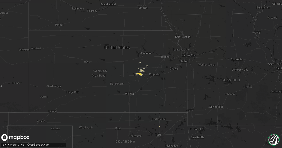
Get this storm
September 13 map
$229
one time, instant access
Download today. No call, no setup
Keep the $229
Bought the map and want the full workflow? Apply the entire $229 to a subscription within 7 days. None of it is wasted.
Every map, not just this one
This buys you this map. Subscription and you get every map we run, in the markets you choose from a few cities to whole states to nationwide. Plus real-time alerts the moment a storm fires.
Contact data
Name, contact info, occupancy, even credit band for addresses in the footprint. You go from where it hit to who to call.
Become the source they trust
Unlimited branding weather history reports on demand. You already have the documented answer ready for the property owner, and you are the one who showed up with it.
Property data and RoofTrace estimates
Pull up any address you have got, its value and the exact code rules for that jurisdiction, straight from One Click Code. Then RoofTrace estimates the squares, pitch, and roof value, priced the way you price.
States Impacted by Hail Map on September 13, 2026
Storm reports
Pennsylvania
| Date | Description |
|---|---|
| 09/13/20266:16 PM CDT | Trees down on wires along lines road. |
| 09/13/20265:32 PM CDT | Tree and wires down across the road. Time estimated via radar. |
| 09/13/20265:08 PM CDT | Tree down blocking the driveway. Time estimated via radar. |
| 09/13/20265:05 PM CDT | Tree down on wires at the intersection of route 219 and halsey road. |
| 09/13/20264:40 PM CDT | Wires down across the road. Time estimated via radar. |
| 09/13/20264:40 PM CDT | Tree down across the road. Time estimated via radar. |
| 09/13/20263:50 PM CDT | Tree down across road near state route 89. |
| 09/13/20263:22 PM CDT | Tree and wires down across state highway 98 near rogers ferry rd. |
New Mexico
| Date | Description |
|---|---|
| 09/13/20266:30 PM CDT | Delayed report. Time estimated. Trailer home flipped over and damage reported to a shed. |
| 09/13/20266:25 PM CDT | Based on radar imagery and damage indicators... A wet microburst occurred around 5:25pm mdt causing a mobile home to roll over with an estimated wind speed of 85 mph. T |
Montana
| Date | Description |
|---|---|
| 09/13/20266:45 PM CDT | Location estimated. |
| 09/12/202610:00 PM CDT | Delayed report: a trained weather spotter reported quarter |
| 09/12/20267:10 PM CDT | Time estimated from radar. |
Tennessee
| Date | Description |
|---|---|
| 09/13/20265:35 PM CDT | A couple of homes suffered minor roof damage and there were several snapped or uprooted trees in the cloverport area due to an apparent microburst. Center pivot overtur |
| 09/13/20264:35 PM CDT | Brick wall damaged on building. Several trees down in town. |
Ohio
| Date | Description |
|---|---|
| 09/13/20266:36 PM CDT | Tree down along sr 26. Time estimated from radar. |
| 09/13/20266:29 PM CDT | Tree down on mcinturf road in stockport. |
| 09/13/20266:29 PM CDT | Tree down o jordan run road in guysville... Ohio. |
| 09/13/20266:18 PM CDT | Corrects previous tstm wnd dmg report from 6 w belpre. Tree down at the intersection of sr 555 and sr 7. Time corrected from am to pm. |
| 09/13/20266:18 PM CDT | Tree and lines down in the 60 block of e palmer st. Time estimated from radar. |
| 09/13/20266:14 PM CDT | Tree down along stanley road. |
| 09/13/20266:00 PM CDT | 2 trees down on county road 11 in unionville. |
| 09/13/20265:55 PM CDT | Downed tree on school road. |
| 09/13/20265:46 PM CDT | Tree damage resulting in approximately 140 customers without power. |
| 09/13/20265:31 PM CDT | Tree down on lines. |
| 09/13/20264:25 PM CDT | Roof ripped off of a home and multiple trees down in fox township. Time estimated via radar. |
| 09/12/20267:10 PM CDT | Tree down along sr 26. |
| 09/12/20267:10 PM CDT | Tree down on waterford road. |
| 09/12/20267:05 PM CDT | Corrects previous tstm wnd dmg report from 12 e marietta for time of occurrence... Which has been updated via an estimate from radar. Tree down along stanley road. |
Arizona
| Date | Description |
|---|---|
| 09/13/20263:00 PM CDT | Social media report. |
| 09/12/20269:24 PM CDT | Personal weather station recorded gust of 61 mph. |
New York
| Date | Description |
|---|---|
| 09/13/20266:46 PM CDT | Tree limbs... Wires and a utility pole downed on north main street. |
| 09/13/20265:45 PM CDT | Tree and wires down on route 26. |
| 09/13/20264:39 PM CDT | Franklin county dispatch received several reports of trees down in bombay. Time estimated from radar. |
| 09/13/20262:34 PM CDT | Tree down blocking lane of traffic on old seneca turnpike rd. |
| 09/12/20267:55 PM CDT | Large pine trees downed with damage on a property near elmore robinson road. |
Nebraska
| Date | Description |
|---|---|
| 09/13/20262:23 AM CDT | A local report indicates 1.00 inch wind near 2 S Sterling |
Mississippi
| Date | Description |
|---|---|
| 09/13/20262:56 PM CDT | A tree was downed on nub mcnair rd. |
| 09/13/20262:45 PM CDT | A tree was downed along warren cook rd. |
| 09/13/20264:50 AM CDT | A tree was downed at n ratliff rd and s springdale rd... Partially blocking the road. |
West Virginia
| Date | Description |
|---|---|
| 09/13/20266:39 PM CDT | Tree down at pettyville rd and badgley fork rd. Time estimated from radar. |
| 09/13/20266:38 PM CDT | Tree in roadway badgley fork rd and sams creek rd. Time estimated from radar. |
| 09/13/20266:38 PM CDT | Tree down in the 900 block of pettyville rd and blocking. Time estimated from radar. |
| 09/13/20266:30 PM CDT | Tree fell onto apartment in the 100 block of wildwood rd. Time estimated from radar. |
| 09/12/20267:06 PM CDT | Tree down blocking one lane of route 16. Time is estimated by radar. |
Cities Impacted by Hail Map on September 13, 2026
- Skiatook, OK
- Ramona, OK
- Marion, KS
- Lincolnville, KS
- Collinsville, OK
- Elmdale, KS
- Strong City, KS
- Burdick, KS
- Herington, KS
- Cottonwood Falls, KS
- Wilsey, KS
- Council Grove, KS
- White City, KS
- Weedsport, NY
- Auburn, NY
- Mendenhall, MS
- San Simon, AZ
- Mayer, AZ
- Grand Canyon, AZ
- Supai, AZ
- Williams, AZ
- Vicksburg, MS
- Trinidad, CO
- Waterloo, NY
- Seneca Falls, NY
- Chatham, LA
- Somerset, OH
- Winkelman, AZ
- Jonesboro, LA
- Conchas Dam, NM
- New Lexington, OH
- Mount Perry, OH
- Roseville, OH
- Cold Brook, NY
- Kim, CO
- Carbondale, CO
- Whipple, OH
- Lower Salem, OH
- Lowell, OH
- Marietta, OH
- Belt, MT
- Raynesford, MT
- Reno, OH
- Monarch, MT
- Geyser, MT
- Guernsey, WY
- Duchesne, UT
- Arnoldsburg, WV
- Spencer, WV
- Creston, WV
- Hartville, WY
- Wheatland, WY
- Douglas, AZ
- Jay Em, WY
- Stockett, MT
- Lucedale, MS
- Vernal, UT
- Torrington, WY
- Maybell, CO
- Geraldine, MT
- Hermosa, SD
- Lusk, WY
- Philip, SD
- Midland, SD
- Willcox, AZ
- Hulett, WY
- Alzada, MT
- Baileyville, KS
- Cortland, NE
- Pickrell, NE
- Seneca, KS
- Adams, NE
- Du Bois, NE
- Pawnee City, NE
- Bern, KS
- Camp Crook, SD
- Buffalo, SD
- Tecumseh, NE
- Crab Orchard, NE
- Utica, NE
- Seward, NE
- Firth, NE
- Sabetha, KS
- Staplehurst, NE
- Sterling, NE
- Table Rock, NE
- Humboldt, NE
- Elk Creek, NE
- Lincoln, NE
- Hickman, NE
- Ulysses, NE
- Rising City, NE
- Martell, NE
- Osceola, NE
- Shelby, NE
- Dwight, NE
- Bennet, NE
- Panama, NE
- Dawson, NE
- Salem, NE
- Bellwood, NE
- Columbus, NE
- Silver Creek, NE
- David City, NE
- Monroe, NE
- Walton, NE
- Brainard, NE
- Raymond, NE
- Davey, NE
- Palmyra, NE
- Valparaiso, NE
- Ceresco, NE
- Verdon, NE
- Platte Center, NE
- Bruno, NE
- Cook, NE
- Humphrey, NE
- Stella, NE
- Creston, NE
- Prague, NE
- Linwood, NE
- Madison, NE
- Waverly, NE
- Wahoo, NE
- Brock, NE
- Weston, NE
- Hiawatha, KS
- Creighton, NE
- Brunswick, NE
- Leigh, NE
- Abie, NE
- Ithaca, NE
- Malmo, NE
- Clarkson, NE
- Forest City, MO
- Unadilla, NE
- Colon, NE
- Roca, NE
- Schuyler, NE
- Norfolk, NE
- Chamberlain, SD
- Pukwana, SD
- Platte, SD
- Stanton, NE
- Kimball, SD
- Oregon, MO
- Cedar Bluffs, NE
- Lathrop, MO
- White Lake, SD
- Shubert, NE
- Fremont, NE
- Amazonia, MO
- Mead, NE
- Tyndall, SD
- Savannah, MO
- Fillmore, MO
- Rogers, NE
- Owanka, SD
- Wasta, SD
- Turney, MO
- Dunbar, NE
- Talmage, NE
- Syracuse, NE
- Onaga, KS
- Corning, KS
- Faith, SD
- Wall, SD
- Milesville, SD
- Alexandria, SD
- Dimock, SD
- Ethan, SD
- Emery, SD
- McLaughlin, SD
- Hayes, SD
- Fort Pierre, SD
- Wakpala, SD
- Bridgewater, SD
- Little Eagle, SD
- Spencer, SD
- Walthill, NE
- Winnebago, NE
- Vivian, SD
- Presho, SD
- Eureka, SD
- Otoe, NE
- Salineville, OH
- Mechanicstown, OH
- Brownsville, TN
- Toone, TN