Hail Map on September 14, 2026
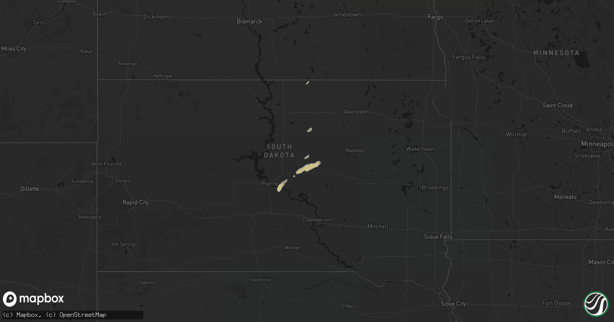
Get this storm
September 14 map
$229
one time, instant access
Download today. No call, no setup
Keep the $229
Bought the map and want the full workflow? Apply the entire $229 to a subscription within 7 days. None of it is wasted.
Every map, not just this one
This buys you this map. Subscription and you get every map we run, in the markets you choose from a few cities to whole states to nationwide. Plus real-time alerts the moment a storm fires.
Contact data
Name, contact info, occupancy, even credit band for addresses in the footprint. You go from where it hit to who to call.
Become the source they trust
Unlimited branding weather history reports on demand. You already have the documented answer ready for the property owner, and you are the one who showed up with it.
Property data and RoofTrace estimates
Pull up any address you have got, its value and the exact code rules for that jurisdiction, straight from One Click Code. Then RoofTrace estimates the squares, pitch, and roof value, priced the way you price.
States Impacted by Hail Map on September 14, 2026
Storm reports
Colorado
| Date | Description |
|---|---|
| 09/14/20265:30 PM CDT | [landspout] |
Iowa
| Date | Description |
|---|---|
| 09/14/20261:00 AM CDT | Measure from a public mesonet station. |
| 09/13/202611:42 PM CDT | Measured gust from a public mesonet station. |
| 09/13/202610:13 PM CDT | Awos measured wind gust of 62 mph. |
| 09/13/202610:06 PM CDT | A local report indicates 63 MPH wind near 3 S Creston |
| 09/13/20269:40 PM CDT | A local report indicates 60 MPH wind near 8 WSW Sidney |
| 09/13/20269:25 PM CDT | Received photos of downed trees and tree limbs around the iowa state university campus. Time estimated from radar. |
| 09/13/20269:22 PM CDT | Picture of tree damage near welch hall on isu campus. Branches are between 6 and 8 inches in diameter. Time estimated by radar. Relayed via social media. |
| 09/13/20268:56 PM CDT | Trees and power lines down in a couple different areas. |
| 09/13/20268:53 PM CDT | Personal weather station. |
| 09/13/20268:28 PM CDT | Adair co reported a tree down outside bridgewater. Time of occurrence was unknown... So estimated from radar. Delayed report. |
| 09/13/20268:15 PM CDT | Measured gust from an iadot mesonet station. |
| 09/13/20267:20 PM CDT | Personal weather station. |
Kansas
| Date | Description |
|---|---|
| 09/14/20266:55 PM CDT | A local report indicates 59 MPH wind near 1 SW Richfield |
| 09/14/20266:55 PM CDT | Mesonet records 58 mph gust. |
| 09/14/20266:36 PM CDT | Station reports 59 mph 1 minute after nearby station. |
| 09/14/20266:35 PM CDT | Personal weather station reports 59 mph gust. |
| 09/14/20266:06 PM CDT | A local report indicates 60 MPH wind near Richfield |
| 09/14/20266:05 PM CDT | Personal weather station reports 69 mph wind gust. |
| 09/14/20265:30 PM CDT | Downed powerlines at the intersection of n big lowe rd and barlow rd. |
| 09/14/20265:03 PM CDT | Delayed report of khlc 65 mph wind report. |
| 09/14/20264:47 PM CDT | Personal weather station reports gust to 83mph. |
| 09/14/20264:43 PM CDT | A local report indicates 58 MPH wind near 11 NE Kendall |
| 09/14/20264:43 PM CDT | A local report indicates 58 MPH wind near 16 NNE Kendall |
| 09/14/20264:42 PM CDT | Kk82 reports gust to 61mph. |
| 09/14/20264:32 PM CDT | A local report indicates 70 MPH wind near 5 SSW Amy |
| 09/14/20264:31 PM CDT | A local report indicates 76 MPH wind near 4 N Kendall |
| 09/14/20264:23 PM CDT | A local report indicates 66 MPH wind near 7 E Shallow Water |
| 09/14/20264:23 PM CDT | Personal weather station reports gust to 60mph. |
| 09/14/20264:20 PM CDT | A local report indicates 77 MPH wind near 4 NNW Amy |
| 09/14/20264:09 PM CDT | A local report indicates 59 MPH wind near 2 WNW Shallow Water |
| 09/14/20262:50 PM CDT | A local report indicates 60 MPH wind near 16 NNW Manter |
| 09/13/20268:23 PM CDT | Raws cglk1 reported. |
| 09/13/20268:05 PM CDT | Kansas mesonet station reported. |
Mississippi
| Date | Description |
|---|---|
| 09/14/20265:10 PM CDT | A tree was downed on cox ferry rd near ms hwy 22... Partially blocking the road. |
| 09/14/20264:50 PM CDT | Corrects previous tstm wnd dmg report from 4 sw pocahontas for time. A tree was downed at n ratliff rd and s springdale rd... Partially blocking the road. |
| 09/14/20264:24 PM CDT | A tree was downed on westhaven blvd blocking both lanes of traffic. |
Nebraska
| Date | Description |
|---|---|
| 09/14/20266:51 PM CDT | Delayed report of a whole tree blocking adams street just eat of highway 50. Time estimated via radar. |
| 09/14/20266:51 PM CDT | A local report indicates 75 MPH wind near 5 ESE Elmwood |
| 09/14/20266:49 PM CDT | An ef-0 tornado touched down in an agricultural field just south of county road b... Between 32nd and 34th roads... Flattening a path through corn. The tornado tracked |
| 09/14/20266:39 PM CDT | Large tree down across county road 8 and b. |
| 09/14/20266:09 PM CDT | 3 to 6 inch diameter branches down. Time estimated from radar. |
| 09/14/20265:48 PM CDT | Personal weather station reports gust to 65 mph. |
| 09/14/20265:02 PM CDT | Fire department reports 60 mph winds southwest of shickley. |
| 09/14/20265:02 PM CDT | Personal weather station reports gust to 60 mph. |
| 09/14/20264:56 PM CDT | Personal weather station reports gust to 61mph. |
| 09/14/20264:47 PM CDT | Emergency manager reports 65mph wind gusts between nelson and superior. |
| 09/14/20264:24 PM CDT | Nebraska mesonet reports gust to 87mph. |
| 09/14/20264:23 PM CDT | Personal weather station reports gust to 68mph. |
| 09/14/20264:23 PM CDT | Personal weather station reports gust to 64mph. |
| 09/14/20264:17 PM CDT | Personal weather station reports gust to 65mph. |
| 09/14/20264:16 PM CDT | Nebraska mesonet reports gust to 65mph. |
| 09/14/202612:30 AM CDT | Wind gust measured from a public mesonet station. |
| 09/13/202611:58 PM CDT | 58 mph measured with 35-40 mph sustained winds underneath a likely microburst. |
| 09/13/20268:51 PM CDT | Personal weather station. |
| 09/13/20268:37 PM CDT | Pole barn had roof blown off. Time estimated based on radar and nearby reports. |
| 09/13/20268:35 PM CDT | A local report indicates 76 MPH wind near 2 NNW Beatrice |
| 09/13/20268:32 PM CDT | Measured on personal weather station. |
| 09/13/20268:30 PM CDT | Estimated 70 mph or stronger winds. |
| 09/13/20267:45 PM CDT | Trees down. Time estimated based on security video. |
| 09/13/20267:33 PM CDT | Personal weather station reports 59 mph. |
| 09/13/20267:04 PM CDT | Personal weather station records 59 mph. |
| 09/13/20267:00 PM CDT | Delayed report of full trees down on the road on nehawka spur. Time and locations estimated from radar. |
Texas
| Date | Description |
|---|---|
| 09/13/20269:38 PM CDT | A local report indicates 60 MPH wind near 3 W Dumas |
Louisiana
| Date | Description |
|---|---|
| 09/14/20266:20 PM CDT | Law enforcement reports tree down blocking northbound lane of us 171. |
Arizona
| Date | Description |
|---|---|
| 09/14/20266:26 PM CDT | Measured wind gust of 60 mph. |
| 09/14/20266:20 PM CDT | Power pole knocked down with tree... Blocking road. |
Missouri
| Date | Description |
|---|---|
| 09/13/20269:58 PM CDT | Delayed report. Present weather sensor. |
Cities Impacted by Hail Map on September 14, 2026
- Pierre, SD
- Fort Pierre, SD
- Onaka, SD
- Eureka, SD
- Harrold, SD
- Highmore, SD
- Holabird, SD
- Miller, SD
- Odell, IL
- Pontiac, IL
- Emington, IL
- Griswold, IA
- Elliott, IA
- Red Oak, IA
- Henderson, IA
- Carson, IA
- Emerson, IA
- Lewis, IA
- Atlantic, IA
- Perry, IA
- Ogden, IA
- Boone, IA
- Crownpoint, NM
- Lehigh, IA
- Stratford, IA
- Webster City, IA
- Williams, IA
- Bayfield, CO
- Redvale, CO
- Lindrith, NM
- Gallup, NM
- Kendall, KS
- Syracuse, KS
- Chambers, AZ
- Manter, KS
- Deerfield, KS
- Huachuca City, AZ
- Quinter, KS
- Scott City, KS
- Marienthal, KS
- Bisbee, AZ
- Sierra Vista, AZ
- Leoti, KS
- Tohatchi, NM
- Navajo, NM
- Pie Town, NM
- Healy, KS
- Elkhart, KS
- Walsh, CO
- Center, CO
- Hooper, CO
- Pearce, AZ
- Saint Johns, AZ
- Burr Oak, KS
- Esbon, KS
- Guide Rock, NE
- Superior, NE
- Nelson, NE
- Oak, NE
- Davenport, NE
- Ayr, NE
- Blue Hill, NE
- Glenvil, NE
- Morland, KS
- Ignacio, CO
- Lakin, KS
- Ganado, AZ
- Dighton, KS
- Fairfield, NE
- Saronville, NE
- Clay Center, NE
- Harvard, NE
- Carleton, NE
- Hardy, NE
- Deshler, NE
- Ruskin, NE
- Shickley, NE
- Edgar, NE
- Campo, CO
- Penokee, KS
- Flora, MS
- Cochise, AZ
- Hill City, KS
- Interlachen, FL
- Hawthorne, FL
- Gaylord, KS
- Smith Center, KS
- Athol, KS
- Lebanon, KS
- Portis, KS
- Downs, KS
- Bruning, NE
- Ohiowa, NE
- Strang, NE
- Hebron, NE
- Geneva, NE
- Ong, NE
- Sutton, NE
- Fairmont, NE
- Exeter, NE
- Bogue, KS
- Navajo Dam, NM
- Garden City, KS
- Jackson, MS
- Pinehill, NM
- Mankato, KS
- Belvidere, NE
- Milligan, NE
- Friend, NE
- Tobias, NE
- Alexandria, NE
- Western, NE
- Daykin, NE
- Pagosa Springs, CO
- Arboles, CO
- Maurepas, LA
- Lenora, KS
- Wilber, NE
- Swanton, NE
- Plymouth, NE
- Logan, KS
- Richfield, KS
- Craig, NE
- Oakland, NE
- Decatur, NE
- Tucson, AZ
- Stockton, KS
- Deridder, LA
- Tekamah, NE
- Prairie View, KS
- Lincoln, NE
- Davey, NE
- Ceresco, NE
- Waverly, NE
- Sahuarita, AZ
- Rayville, LA
- Nogales, AZ
- Vail, AZ
- Longville, LA
- Palmyra, NE
- Bennet, NE
- Walton, NE
- Eagle, NE
- Syracuse, NE
- Unadilla, NE
- Elmwood, NE
- Murdock, NE
- Avoca, NE
- Weeping Water, NE
- Otoe, NE
- Nehawka, NE
- Nebraska City, NE
- Plattsmouth, NE
- Murray, NE
- Union, NE
- Council Bluffs, IA
- Treynor, IA
- McClelland, IA
- Oakland, IA
- Elgin, AZ
- Tecumseh, NE
- Shiprock, NM
- Sterling, NE
- Dow City, IA
- Minden, IA
- Hancock, IA
- Thurman, IA
- Percival, IA
- Pacific Junction, IA
- Glenwood, IA
- Malvern, IA
- Tabor, IA
- Sidney, IA
- Randolph, IA
- Imogene, IA
- Hastings, IA
- Macedonia, IA
- Cook, NE
- Talmage, NE
- Denison, IA
- Manilla, IA
- Vail, IA
- Arion, IA
- Walnut, IA
- Marne, IA
- Auburn, NE
- Brock, NE
- Johnson, NE
- Lordsburg, NM
- Villisca, IA
- Massena, IA
- Cumberland, IA
- Grant, IA
- Gateway, CO
- Peru, NE
- De Witt, NE
- Adair, IA
- Wiota, IA
- Bridgewater, IA
- Anita, IA
- Fontanelle, IA
- Greenfield, IA
- Casey, IA
- Dunbar, NE
- Hamburg, IA
- Farragut, IA
- Riverton, IA
- Essex, IA
- Shenandoah, IA
- Clarinda, IA
- Beatrice, NE
- Menlo, IA
- Stuart, IA
- Pickrell, NE
- Cortland, NE
- Adams, NE
- Filley, NE
- Crab Orchard, NE
- Stanton, IA
- Julian, NE
- Montrose, CO
- Elk Creek, NE
- Rock Port, MO
- Watson, MO
- Burr, NE
- Westboro, MO
- Northboro, IA
- Elmo, MO
- Blanchard, IA
- Brownville, NE
- Coin, IA
- Lorton, NE
- Douglas, NE
- Tarkio, MO
- Yorktown, IA
- Farmington, NM
- Fort Calhoun, NE
- Crescent, IA
- Omaha, NE
- Bennington, NE
- Valley, NE
- Elkhorn, NE
- Blair, NE
- Kennard, NE
- Missouri Valley, IA
- Shelby, IA
- Avoca, IA
- Underwood, IA
- Neola, IA
- Exira, IA
- Brayton, IA
- Panora, IA
- Guthrie Center, IA
- Redfield, IA
- Dexter, IA
- Linden, IA
- Phillipsburg, KS
- Lenox, IA
- Creston, IA