Hail Map in North Carolina on July 31, 2022
Get this storm
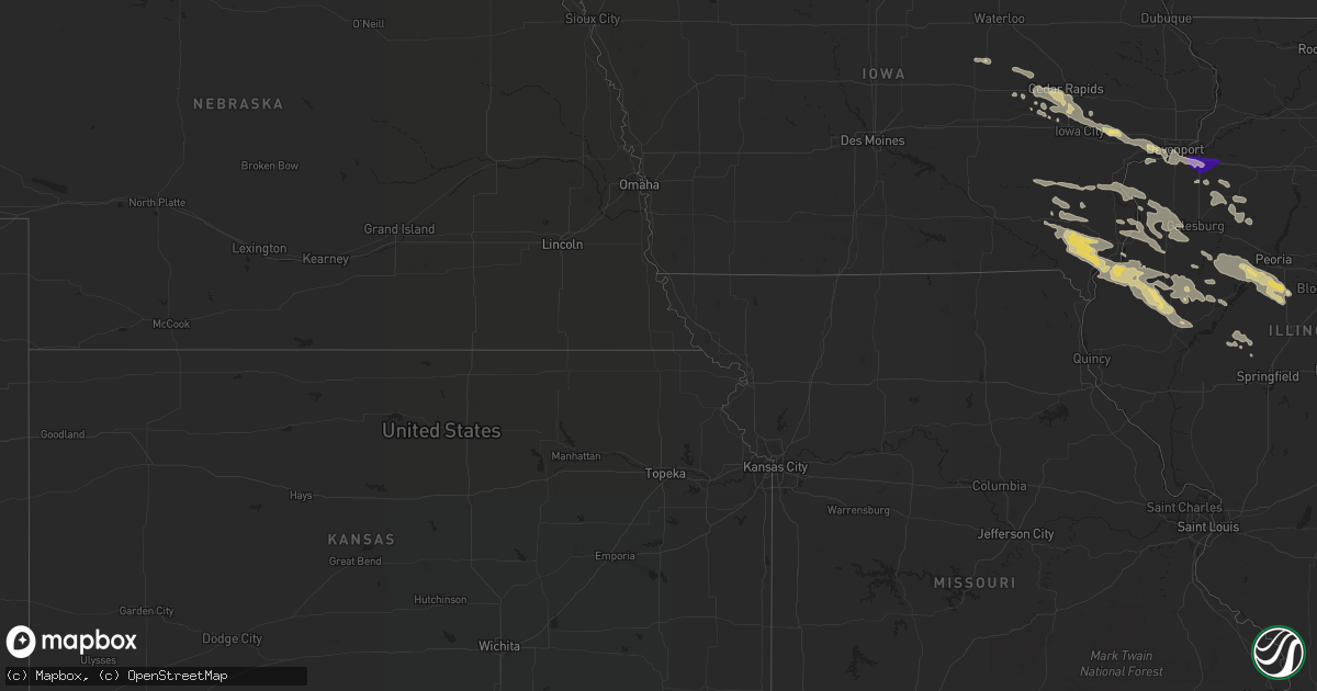
July 31 map
$229
one time, instant access
Download today. No call, no setup
Keep the $229
Bought the map and want the full workflow? Apply the entire $229 to a subscription within 7 days. None of it is wasted.
Every map, not just this one
This buys you this map. Subscription and you get every map we run, in the markets you choose from a few cities to whole states to nationwide. Plus real-time alerts the moment a storm fires.
Contact data
Name, contact info, occupancy, even credit band for addresses in the footprint. You go from where it hit to who to call.
Become the source they trust
Unlimited branding weather history reports on demand. You already have the documented answer ready for the property owner, and you are the one who showed up with it.
Property data and RoofTrace estimates
Pull up any address you have got, its value and the exact code rules for that jurisdiction, straight from One Click Code. Then RoofTrace estimates the squares, pitch, and roof value, priced the way you price.
Storm reports in North Carolina
North Carolina
| Date | Description |
|---|---|
| 07/31/20225:40 PM CDT | 911 center reports tree down at the intersection of stewart dr and harkers island rd. Time estimated by radar. |
| 07/31/20225:24 PM CDT | 911 call center reports tree down at the intersection of adams creek rd and hwy 101. Time estimated by radar. |
| 07/31/20225:20 PM CDT | Trees down along harmony hwy. |
| 07/31/20225:20 PM CDT | Tree downed along hunting creek rd. |
| 07/31/20225:12 PM CDT | 911 call center reports tree down at the intersection of brandywine blvd and hwy 24. Time estimated by radar. |
| 07/31/20224:37 PM CDT | Ham radio relayed reported of branches down at the intersection of piney green rd. And country club rd. Time based on radar. |
| 07/31/20224:31 PM CDT | Ham radio relayed report of 50-60 mph gusts at the intersection of hwy17 and western blvd. In jacksonville. Time based on radar. |
| 07/31/20224:23 PM CDT | Onslow county 911 reported trees down near the intersection of blue creek rd. And pony farm rd. Time based on radar. |
| 07/31/20224:11 PM CDT | Onslow county 911 reported large limbs down near the intersection of padgett rd. And haws run rd. Time based on radar. |
| 07/31/202212:29 PM CDT | Tree down near the intersection of ringwood road and heathsville road. Time estimated by radar. |
| 07/31/20221:06 AM CDT | At 605 PM EDT, severe thunderstorms were located along a line extending from near Havelock to near Newport to near Broad Creek, moving northeast at 40 mph. HAZARD...70 mph wind gusts and nickel size hail. SOURCE...Radar indicated. IMPACT...Expect considerable tree damage. Damage is likely to mobile homes, roofs, and outbuildings. Locations impacted include... New Bern, Havelock, Morehead City, Newport, Cedar Island, Harkers Island, South River, North River, Sealevel, Marshallberg, Davis, Smyrna, Merrimon, Straits, Atlantic, Pine Knoll Shores, Harlowe, Florence, Otway and Janeiro. |
| 07/31/202212:42 AM CDT | At 542 PM EDT, severe thunderstorms were located along a line extending from near Maysville to near Camp Lejeune Center, moving east at 25 mph. HAZARD...70 mph wind gusts and nickel size hail. SOURCE...Radar indicated. IMPACT...Expect considerable tree damage. Damage is likely to mobile homes, roofs, and outbuildings. Locations impacted include... Jacksonville, New Bern, Havelock, Morehead City, Newport, Pumpkin Center, Piney Green, Camp Lejeune Center, James City, Trent Woods, River Bend, Stella, Swansboro, Hubert, Cape Carteret, Maysville, Silverdale, Kellum, Midway Park and Belgrade. |
| 07/30/202211:59 PM CDT | At 459 PM EDT, severe thunderstorms were located along a line extending from 6 miles northeast of Murray Town to Edgecomb, moving northeast at 25 mph. HAZARD...60 mph wind gusts and quarter size hail. SOURCE...Radar indicated. IMPACT...Hail damage to vehicles is expected. Expect wind damage to roofs, siding, and trees. Locations impacted include... Jacksonville, Morehead City, North Topsail Beach, New River Station, Pumpkin Center, Piney Green, Half Moon, Camp Lejeune Center, Swansboro, Hubert, Richlands, Beulaville, Catherine Lake, Folkstone, Silverdale, Kellum, Cypress Creek, Midway Park, Verona and Dixon. |
| 07/30/202211:22 PM CDT | At 421 PM EDT, a severe thunderstorm was located over Barefoot Landing Area Of North Myrtle Beach, or near North Myrtle Beach Airport, moving southeast at 5 mph. HAZARD...60 mph wind gusts. SOURCE...Radar indicated. IMPACT...Expect wind damage to trees and power lines. Locations impacted include... Myrtle Beach, North Myrtle Beach, Little River, North Myrtle Beach Airport, Wampee, Hand, Nixonville, Barefoot Landing Area Of North Myrtle Beach, Briarcliffe Acres, Atlantic Beach, Sea Coast Medical Center and Grand Strand Regional Medical Center. |
| 07/30/202210:00 PM CDT | At 300 PM EDT, severe thunderstorms were located along a line extending from near Ebony to near Rocky Mount, moving northeast at 25 mph. HAZARD...60 mph wind gusts and quarter size hail. SOURCE...Radar indicated. IMPACT...Hail damage to vehicles is expected. Expect wind damage to roofs, siding, and trees. Locations impacted include... Rocky Mount, Roanoke Rapids, Halifax, Scotland Neck, Littleton, Enfield, Weldon, Whitakers, Leggett and Glenview. |
| 07/30/20228:28 PM CDT | At 128 PM EDT, a severe thunderstorm was located 11 miles southwest of Halifax, moving east at 10 mph. HAZARD...60 mph wind gusts and quarter size hail. SOURCE...Radar indicated. IMPACT...Hail damage to vehicles is expected. Expect wind damage to roofs, siding, and trees. Locations impacted include... Enfield, Whitakers and Tillery. |
All States Impacted by Hail Map on July 31, 2022
Cities Impacted by Hail Map on July 31, 2022
- Deer Park, WI
- Clear Lake, WI
- Milltown, WI
- Luck, WI
- Winfield, IA
- Saint Paul, MN
- Lake Elmo, MN
- Alma, WI
- Waverly, IA
- Aitkin, MN
- Frederic, WI
- Sisters, OR
- Marengo, IA
- Watkins, IA
- Homestead, IA
- Oxford, IA
- Walnut Grove, MN
- Revere, MN
- Champaign, IL
- Ivesdale, IL
- Tolono, IL
- Webster, WI
- Shell Lake, WI
- Siren, WI
- Lewistown, IL
- Bushnell, IL
- Salem, IA
- New London, IA
- Hillsboro, IA
- Browning, IL
- West Burlington, IA
- Middletown, IA
- Farmington, IA
- Carthage, IL
- West Point, IA
- Rushville, IL
- Lomax, IL
- Table Grove, IL
- Littleton, IL
- Bardolph, IL
- Smithfield, IL
- Marietta, IL
- Colchester, IL
- Good Hope, IL
- Plymouth, IL
- Industry, IL
- Tennessee, IL
- Wever, IA
- Mount Pleasant, IA
- Fort Madison, IA
- Lockridge, IA
- La Harpe, IL
- Dallas City, IL
- Stockport, IA
- Danville, IA
- Blandinsville, IL
- Saint Paul, IA
- Adair, IL
- Astoria, IL
- Niota, IL
- Macomb, IL
- Nauvoo, IL
- Donnellson, IA
- Fairfield, IA
- Ipava, IL
- Sciota, IL
- Canistota, SD
- Salem, SD
- Braham, MN
- Pine City, MN
- Benson, NC
- Four Oaks, NC
- Nunda, SD
- Media, IL
- Biggsville, IL
- Roseville, IL
- Mediapolis, IA
- Smithshire, IL
- Oquawka, IL
- Gladstone, IL
- Kirkwood, IL
- Burlington, IA
- Norway, IA
- Amana, IA
- Decatur, IL
- Yucca, AZ
- Petersburg, IL
- Oakford, IL
- Pioche, NV
- Dover, MN
- Eyota, MN
- Plainview, MN
- Benson, AZ
- State Line, IN
- Bismarck, IL
- Potomac, IL
- Covington, IN
- Danville, IL
- Collison, IL
- Rossville, IL
- Oakville, IA
- Seaton, IL
- Wapello, IA
- Columbus Junction, IA
- New Boston, IL
- Muscatine, IA
- Joy, IL
- Lynn Center, IL
- Arthur, IL
- Arcola, IL
- Macon, IL
- Jacksonville, NC
- Hopedale, IL
- Tremont, IL
- Grantsburg, WI
- Elgin, MN
- Rochester, MN
- Millville, MN
- Saint Charles, MN
- Villa Grove, IL
- Newman, IL
- Brocton, IL
- Oakland, IL
- Hume, IL
- Murdock, IL
- Camargo, IL
- Wells, MN
- Alden, MN
- Rush City, MN
- Luzerne, IA
- Blairstown, IA
- Maquon, IL
- Peoria, IL
- Hanna City, IL
- Glasford, IL
- Norris, IL
- Farmington, IL
- Kingston Mines, IL
- Elmwood, IL
- Yates City, IL
- Fairview, IL
- Trivoli, IL
- Canton, IL
- Mapleton, IL
- Delavan, IL
- Green Valley, IL
- South Pekin, IL
- Pekin, IL
- Manito, IL
- Sahuarita, AZ
- Farmington, MN
- Northfield, MN
- Lakeville, MN
- Moweaqua, IL
- Montrose, SD
- Tuscola, IL
- Oldham, SD
- Arlington, SD
- Ramona, SD
- Speer, IL
- Princeville, IL
- Chandlerville, IL
- Penfield, IL
- Armstrong, IL
- Iowa City, IA
- Walcott, IA
- Atalissa, IA
- Taylor Ridge, IL
- Walford, IA
- Blue Grass, IA
- Stockton, IA
- Atkins, IA
- Newhall, IA
- Swisher, IA
- Durant, IA
- West Liberty, IA
- Moscow, IA
- Ely, IA
- Wilton, IA
- Solon, IA
- West Branch, IA
- Milan, IL
- North Liberty, IA
- Tipton, IA
- Fairfax, IA
- Cedar Rapids, IA
- Davenport, IA
- Pound, WI
- Mapleton, MN
- Danbury, WI
- Tower Hill, IL
- London Mills, IL
- Illinois City, IL
- Marshall, IL
- Paris, IL
- Orion, IL
- Rock Island, IL
- Geneseo, IL
- Moline, IL
- Coal Valley, IL
- Osco, IL
- Minnesota Lake, MN
- Brookings, SD
- Garrison, IA
- Van Horne, IA
- Vinton, IA
- Dysart, IA
- Dewitt, IL
- Clinton, IL
- Wapella, IL
- Cambridge, IL
- Woodhull, IL
- Altona, IL
- Galva, IL
- Oneida, IL
- Sidney, IL
- Philo, IL
- Broadlands, IL
- Longview, IL
- Allerton, IL
- Sidell, IL
- Westville, IL
- Metcalf, IL
- Chrisman, IL
- McLean, IL
- Heyworth, IL
- Waynesville, IL
- Clinton, IN
- Winfred, SD
- Bridgewater, SD
- Emery, SD
- Middle Amana, IA
- Kewanee, IL
- Susanville, CA
- Brighton, IA
- Keota, IA
- Ainsworth, IA
- Crawfordsville, IA
- Washington, IA
- Dennison, MN
- Cannon Falls, MN
- Amboy, MN
- Easton, MN
- Keithsburg, IL
- Cuba, IL
- Sperry, IA
- Victoria, IL
- Laura, IL
- La Fayette, IL
- Toulon, IL
- Madison, SD
- Avon, IL
- Ellisville, IL
- Wayland, IA
- Tucson, AZ
- Deer River, MN
- Vernon Center, MN
- Good Thunder, MN
- Sadorus, IL
- Bement, IL
- Pesotum, IL
- Rutland, SD
- Wentworth, SD
- Colman, SD
- Findlay, IL
- Sullivan, IL
- Windsor, IL
- Traer, IA
- Indianola, IL
- Canadian, TX
- Rosedale, IN
- Julesburg, CO
- Sells, AZ
- Vail, AZ
- Ajo, AZ
- Sidney, NE
- Salome, AZ
- Monticello, IL
- Kingman, IN
- Veedersburg, IN
- Perrysville, IN
- Kansas, IL
- Little York, IL
- Alexis, IL
- Aledo, IL
- Gerlaw, IL
- Cameron, IL
- Galesburg, IL
- Monmouth, IL
- Abingdon, IL
- Tumacacori, AZ
- Tubac, AZ
- Carman, IL
- Lodgepole, NE
- Argenta, IL
- Oreana, IL
- Maroa, IL
- Redmon, IL
- Higgins, TX
- Colona, IL


