Hail Map in Arizona on July 31, 2022
Get this storm
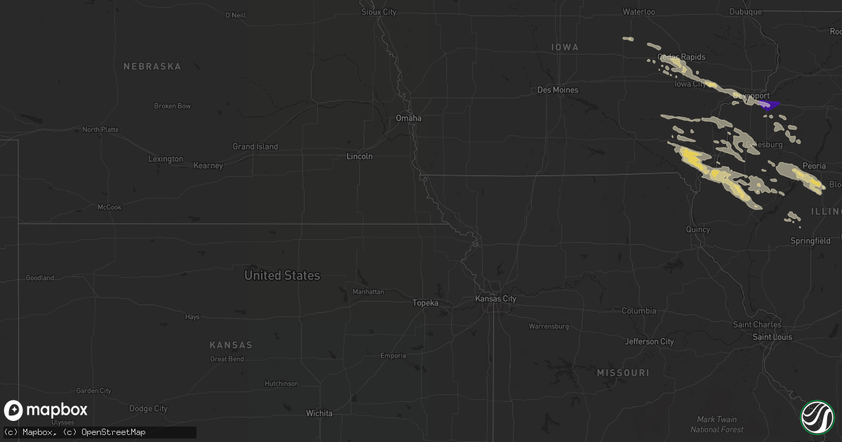
July 31 map
$229
one time, instant access
Download today. No call, no setup
Keep the $229
Bought the map and want the full workflow? Apply the entire $229 to a subscription within 7 days. None of it is wasted.
Every map, not just this one
This buys you this map. Subscription and you get every map we run, in the markets you choose from a few cities to whole states to nationwide. Plus real-time alerts the moment a storm fires.
Contact data
Name, contact info, occupancy, even credit band for addresses in the footprint. You go from where it hit to who to call.
Become the source they trust
Unlimited branding weather history reports on demand. You already have the documented answer ready for the property owner, and you are the one who showed up with it.
Property data and RoofTrace estimates
Pull up any address you have got, its value and the exact code rules for that jurisdiction, straight from One Click Code. Then RoofTrace estimates the squares, pitch, and roof value, priced the way you price.
Storm reports in Arizona
Arizona
| Date | Description |
|---|---|
| 07/31/20226:47 PM CDT | Quarter size hail fell in the eagle crest ranch neighborhood. |
| 07/31/20227:54 AM CDT | At 1254 PM MST, a severe thunderstorm was located near Ajo, moving west at 25 mph. HAZARD...60 mph wind gusts and quarter size hail. SOURCE...Radar indicated. IMPACT...Hail damage to vehicles is expected. Expect wind damage to roofs, siding, and trees. Locations impacted include... Ajo. |
| 07/31/20221:36 AM CDT | At 635 PM MST, a cluster of strong to severe thunderstorms was located 7 miles east of Nogales International Airport, or 12 miles east of Nogales, moving northwest at 20 mph. HAZARD...60 mph wind gusts and nickel size hail. SOURCE...Radar indicated. IMPACT...Expect damage to roofs, siding, and trees. Locations impacted include... Nogales, Rio Rico, Patagonia, Nogales International Airport, Patagonia Lake State Park and Kino Springs. |
| 07/31/202212:58 AM CDT | At 557 PM MST, a severe thunderstorm was located near Tanque Verde, or near Davis-Monthan Air Force Base, moving northwest at 15 mph. HAZARD...60 mph wind gusts and quarter size hail. SOURCE...Radar indicated. IMPACT...Hail damage to vehicles is expected. Expect wind damage to roofs, siding, and trees. Locations impacted include... Tucson, Oro Valley, Marana, Davis-Monthan Air Force Base, Casas Adobes, Flowing Wells, Tanque Verde, Mount Lemmon/Summerhaven, Sabino Canyon Recreation Area, Catalina State Park, Catalina Foothills, Saguaro National Park East and Seven Falls. |
| 07/31/202212:21 AM CDT | At 521 PM MST, a cluster of severe thunderstorm was located near Davis-Monthan Air Force Base, moving northwest at 20 mph. HAZARD...60 mph wind gusts and quarter size hail. SOURCE...Radar indicated. IMPACT...Hail damage to vehicles is expected. Expect wind damage to roofs, siding, and trees. Locations impacted include... Tucson, Davis-Monthan Air Force Base, Casas Adobes, Flowing Wells, Tanque Verde, Vail, South Tucson, Sabino Canyon Recreation Area, Catalina Foothills, Tucson International Airport, Saguaro National Park East, Summit, Rita Ranch and Seven Falls. |
| 07/31/202212:18 AM CDT | At 517 PM MST, a severe thunderstorm was located over Nogales, moving northwest at 10 mph. HAZARD...60 mph wind gusts and quarter size hail. SOURCE...Radar indicated. IMPACT...Hail damage to vehicles is expected. Expect wind damage to roofs, siding, and trees. Locations impacted include... Nogales, Nogales International Airport, Patagonia Lake State Park, Kino Springs and Pena Blanca Lake. |
| 07/31/202212:06 AM CDT | At 505 PM MST, a severe thunderstorm was located over Pascua Pueblo Yaqui Reservation, or 12 miles southwest of Tucson, moving north at 20 mph. HAZARD...70 mph wind gusts and ping pong ball size hail. SOURCE...Radar indicated. IMPACT...People and animals outdoors will be injured. Expect hail damage to roofs, siding, windows, and vehicles. Expect considerable tree damage. Wind damage is also likely to mobile homes, roofs, and outbuildings. Locations impacted include... Tucson, Marana, Casas Adobes, Drexel Heights, Flowing Wells, Pascua Pueblo Yaqui Reservation, Saguaro National Park West, Valencia West, Tucson Estates, Picture Rocks, San Xavier Mission and Ryan AirField. |
| 07/30/202211:52 PM CDT | At 452 PM MST, a severe thunderstorm was located near Three Points, or 14 miles northwest of Sahuarita, moving northwest at 25 mph. HAZARD...60 mph wind gusts and quarter size hail. SOURCE...Radar indicated. IMPACT...Hail damage to vehicles is expected. Expect wind damage to roofs, siding, and trees. Locations impacted include... Three Points, Pascua Pueblo Yaqui Reservation, Valencia West, Tucson Estates, Saguaro National Park West, Picture Rocks, San Pedro and Ryan AirField. |
| 07/30/202211:37 PM CDT | At 436 PM MST, a severe thunderstorm was located near Vail, or 16 miles west of Benson, and is nearly stationary. HAZARD...60 mph wind gusts and quarter size hail. SOURCE...Radar indicated. IMPACT...Hail damage to vehicles is expected. Expect wind damage to roofs, siding, and trees. Locations impacted include... Vail and Saguaro National Park East. |
| 07/30/202210:46 PM CDT | At 346 PM MST, a severe thunderstorm was located over Patagonia Lake State Park, or 11 miles northeast of Nogales, moving west at 10 mph. HAZARD...60 mph wind gusts and quarter size hail. SOURCE...Radar indicated. IMPACT...Hail damage to vehicles is expected. Expect wind damage to roofs, siding, and trees. Locations impacted include... Patagonia and Patagonia Lake State Park. |
| 07/30/202210:31 PM CDT | At 331 PM MST, a severe thunderstorm was located near Tubac, moving northwest at 15 mph. HAZARD...60 mph wind gusts and quarter size hail. SOURCE...Radar indicated. IMPACT...Hail damage to vehicles is expected. Expect wind damage to roofs, siding, and trees. Locations impacted include... Green Valley, Tubac, Amado and Arivaca Junction. |
| 07/30/20227:20 PM CDT | Pictures submitted by public via social media of wind damage to a storage facility. |
All States Impacted by Hail Map on July 31, 2022
Cities Impacted by Hail Map on July 31, 2022
- Deer Park, WI
- Clear Lake, WI
- Milltown, WI
- Luck, WI
- Winfield, IA
- Saint Paul, MN
- Lake Elmo, MN
- Alma, WI
- Waverly, IA
- Aitkin, MN
- Frederic, WI
- Sisters, OR
- Marengo, IA
- Watkins, IA
- Homestead, IA
- Oxford, IA
- Walnut Grove, MN
- Revere, MN
- Champaign, IL
- Ivesdale, IL
- Tolono, IL
- Webster, WI
- Shell Lake, WI
- Siren, WI
- Lewistown, IL
- Bushnell, IL
- Salem, IA
- New London, IA
- Hillsboro, IA
- Browning, IL
- West Burlington, IA
- Middletown, IA
- Farmington, IA
- Carthage, IL
- West Point, IA
- Rushville, IL
- Lomax, IL
- Table Grove, IL
- Littleton, IL
- Bardolph, IL
- Smithfield, IL
- Marietta, IL
- Colchester, IL
- Good Hope, IL
- Plymouth, IL
- Industry, IL
- Tennessee, IL
- Wever, IA
- Mount Pleasant, IA
- Fort Madison, IA
- Lockridge, IA
- La Harpe, IL
- Dallas City, IL
- Stockport, IA
- Danville, IA
- Blandinsville, IL
- Saint Paul, IA
- Adair, IL
- Astoria, IL
- Niota, IL
- Macomb, IL
- Nauvoo, IL
- Donnellson, IA
- Fairfield, IA
- Ipava, IL
- Sciota, IL
- Canistota, SD
- Salem, SD
- Braham, MN
- Pine City, MN
- Benson, NC
- Four Oaks, NC
- Nunda, SD
- Media, IL
- Biggsville, IL
- Roseville, IL
- Mediapolis, IA
- Smithshire, IL
- Oquawka, IL
- Gladstone, IL
- Kirkwood, IL
- Burlington, IA
- Norway, IA
- Amana, IA
- Decatur, IL
- Yucca, AZ
- Petersburg, IL
- Oakford, IL
- Pioche, NV
- Dover, MN
- Eyota, MN
- Plainview, MN
- Benson, AZ
- State Line, IN
- Bismarck, IL
- Potomac, IL
- Covington, IN
- Danville, IL
- Collison, IL
- Rossville, IL
- Oakville, IA
- Seaton, IL
- Wapello, IA
- Columbus Junction, IA
- New Boston, IL
- Muscatine, IA
- Joy, IL
- Lynn Center, IL
- Arthur, IL
- Arcola, IL
- Macon, IL
- Jacksonville, NC
- Hopedale, IL
- Tremont, IL
- Grantsburg, WI
- Elgin, MN
- Rochester, MN
- Millville, MN
- Saint Charles, MN
- Villa Grove, IL
- Newman, IL
- Brocton, IL
- Oakland, IL
- Hume, IL
- Murdock, IL
- Camargo, IL
- Wells, MN
- Alden, MN
- Rush City, MN
- Luzerne, IA
- Blairstown, IA
- Maquon, IL
- Peoria, IL
- Hanna City, IL
- Glasford, IL
- Norris, IL
- Farmington, IL
- Kingston Mines, IL
- Elmwood, IL
- Yates City, IL
- Fairview, IL
- Trivoli, IL
- Canton, IL
- Mapleton, IL
- Delavan, IL
- Green Valley, IL
- South Pekin, IL
- Pekin, IL
- Manito, IL
- Sahuarita, AZ
- Farmington, MN
- Northfield, MN
- Lakeville, MN
- Moweaqua, IL
- Montrose, SD
- Tuscola, IL
- Oldham, SD
- Arlington, SD
- Ramona, SD
- Speer, IL
- Princeville, IL
- Chandlerville, IL
- Penfield, IL
- Armstrong, IL
- Iowa City, IA
- Walcott, IA
- Atalissa, IA
- Taylor Ridge, IL
- Walford, IA
- Blue Grass, IA
- Stockton, IA
- Atkins, IA
- Newhall, IA
- Swisher, IA
- Durant, IA
- West Liberty, IA
- Moscow, IA
- Ely, IA
- Wilton, IA
- Solon, IA
- West Branch, IA
- Milan, IL
- North Liberty, IA
- Tipton, IA
- Fairfax, IA
- Cedar Rapids, IA
- Davenport, IA
- Pound, WI
- Mapleton, MN
- Danbury, WI
- Tower Hill, IL
- London Mills, IL
- Illinois City, IL
- Marshall, IL
- Paris, IL
- Orion, IL
- Rock Island, IL
- Geneseo, IL
- Moline, IL
- Coal Valley, IL
- Osco, IL
- Minnesota Lake, MN
- Brookings, SD
- Garrison, IA
- Van Horne, IA
- Vinton, IA
- Dysart, IA
- Dewitt, IL
- Clinton, IL
- Wapella, IL
- Cambridge, IL
- Woodhull, IL
- Altona, IL
- Galva, IL
- Oneida, IL
- Sidney, IL
- Philo, IL
- Broadlands, IL
- Longview, IL
- Allerton, IL
- Sidell, IL
- Westville, IL
- Metcalf, IL
- Chrisman, IL
- McLean, IL
- Heyworth, IL
- Waynesville, IL
- Clinton, IN
- Winfred, SD
- Bridgewater, SD
- Emery, SD
- Middle Amana, IA
- Kewanee, IL
- Susanville, CA
- Brighton, IA
- Keota, IA
- Ainsworth, IA
- Crawfordsville, IA
- Washington, IA
- Dennison, MN
- Cannon Falls, MN
- Amboy, MN
- Easton, MN
- Keithsburg, IL
- Cuba, IL
- Sperry, IA
- Victoria, IL
- Laura, IL
- La Fayette, IL
- Toulon, IL
- Madison, SD
- Avon, IL
- Ellisville, IL
- Wayland, IA
- Tucson, AZ
- Deer River, MN
- Vernon Center, MN
- Good Thunder, MN
- Sadorus, IL
- Bement, IL
- Pesotum, IL
- Rutland, SD
- Wentworth, SD
- Colman, SD
- Findlay, IL
- Sullivan, IL
- Windsor, IL
- Traer, IA
- Indianola, IL
- Canadian, TX
- Rosedale, IN
- Julesburg, CO
- Sells, AZ
- Vail, AZ
- Ajo, AZ
- Sidney, NE
- Salome, AZ
- Monticello, IL
- Kingman, IN
- Veedersburg, IN
- Perrysville, IN
- Kansas, IL
- Little York, IL
- Alexis, IL
- Aledo, IL
- Gerlaw, IL
- Cameron, IL
- Galesburg, IL
- Monmouth, IL
- Abingdon, IL
- Tumacacori, AZ
- Tubac, AZ
- Carman, IL
- Lodgepole, NE
- Argenta, IL
- Oreana, IL
- Maroa, IL
- Redmon, IL
- Higgins, TX
- Colona, IL


