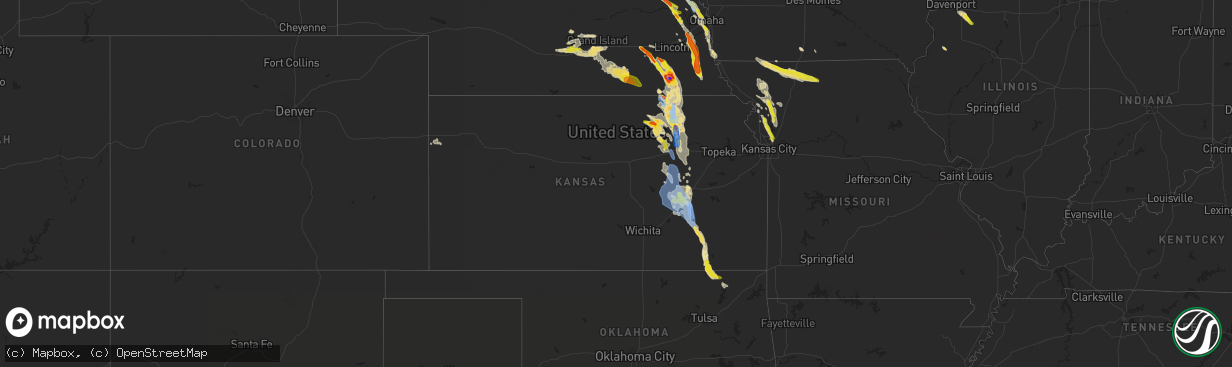
Hail Map in Kansas on June 11, 2022
The weather event in Kansas on June 11, 2022 includes Tornado, Wind, and Hail maps. 18 states and 399 cities were impacted and suffered possible damage. The total estimated number of properties impacted is 3,693.
Want more than just the map?
Turn this storm into a full workflow.
- Owner + property data so you know who to knock
- OnDemand branded weather history reports to win the "did we even have hail?" argument
- RoofTrace estimate so reps stop guessing numbers at the door
Bought this map? Upgrade within 7 days and we'll credit the $230. (10-15 min setup call)
Tornado
Wind
Hail
3,693
Estimated number of impacted properties by a 1.00" hail or larger467
Estimated number of impacted properties by a 1.75" hail or larger0
Estimated number of impacted properties by a 2.50" hail or largerStorm reports in Kansas
Kansas
| Date | Description |
|---|---|
| 06/11/20226:58 PM CDT | A local report indicates 70 MPH wind near 5 S OLSBURG |
| 06/11/20226:40 PM CDT | 12 inch tree limb down as well as multiple smaller limbs as well. |
| 06/11/20226:31 PM CDT | Report from mping: 3-inch tree limbs broken; power poles broken. |
| 06/11/20226:30 PM CDT | Highway 77 closed west of blue rapids due to power lines down along the road. |
| 06/11/20226:30 PM CDT | Delayed report from mping: trees uprooted or snapped; roof blown off. |
| 06/11/20226:25 PM CDT | Ksu mesonet observation. |
| 06/11/20226:24 PM CDT | Report from mping: 3-inch tree limbs broken; power poles broken. |
| 06/11/20226:20 PM CDT | Delayed report from social media... Damage to farm buildings. Time estimated. |
| 06/11/20226:11 PM CDT | Reports of 4 industrial buildings collapsed and power lines down in marysville. Highway 36 has been closed due to debris covering the road. Time estimated from radar. |
| 06/11/20226:08 PM CDT | Delayed report. |
| 06/11/20226:05 PM CDT | A local report indicates 1.50 inch wind near 5 N HANOVER |
| 06/11/20226:03 PM CDT | Report from mping: quarter |
| 06/11/20226:01 PM CDT | Debris along north street in marysville. Many trees down along north street. |
| 06/11/20225:59 PM CDT | Rain wrapped tornado near highway 77. |
| 06/11/20225:54 PM CDT | Reports of tornado on the ground. |
| 06/11/20226:23 AM CDT | At 1123 PM CDT, severe thunderstorms were located along a line extending from 3 miles southwest of Independence to 3 miles northwest of Caney, moving south at 50 mph. HAZARD...60 mph wind gusts and quarter size hail. SOURCE...Radar indicated. IMPACT...Hail damage to vehicles is expected. Expect wind damage to roofs, siding, and trees. Locations in or near the path include... Bartlesville... Nowata... Dewey... South Coffeyville... Copan... Ramona... Ochelata... Delaware... Lenapah... Wann... New Alluwe... Watova... |
| 06/11/20226:06 AM CDT | At 1105 PM CDT, a severe thunderstorm was located near Kearney, moving south at 40 mph. HAZARD...70 mph wind gusts and quarter size hail. SOURCE...Radar indicated. IMPACT...Hail damage to vehicles is expected. Expect considerable tree damage. Wind damage is also likely to mobile homes, roofs, and outbuildings. Locations impacted include... Kansas City, Independence, Liberty, Gladstone, Smithville, Kearney, Parkville, Platte City, North Kansas City, Sugar Creek, Riverside, Weatherby Lake, Claycomo, Courtney, Pleasant Valley, Lake Waukomis, Trimble, Edgerton, Glenaire and Dearborn.This includes the following highways... Interstate 35 in Missouri between mile markers 7 and 32. Interstate 29 between mile markers 0 and 18. Interstate 635 between mile markers 11 and 12. Interstate 435 near mile marker 21, and between mile markers 23 and55. |
| 06/11/20225:58 AM CDT | At 1058 PM CDT, severe thunderstorms were located along a line extending from near Elk City to 7 miles northeast of Sedan to 8 miles southeast of Grenola, moving south at 35 mph. HAZARD...60 mph wind gusts and nickel size hail. SOURCE...Radar indicated. IMPACT...Expect damage to roofs, siding, and trees. Locations impacted include... Coffeyville, Independence, Caney, Sedan, Dearing, Elk City, Tyro, Peru, Chautauqua, Havana, Elgin, Bolton, Niotaze, Elk City Lake, Elk City State Park, Hale and Independence Airport. |
| 06/11/20225:29 AM CDT | At 1029 PM CDT, severe thunderstorms were located along a line extending from near Fall River to Howard to 9 miles southeast of Latham, moving south at 45 mph. HAZARD...70 mph wind gusts and quarter size hail. SOURCE...Radar indicated. IMPACT...Hail damage to vehicles is expected. Expect considerable tree damage. Wind damage is also likely to mobile homes, roofs, and outbuildings. Locations impacted include... Howard, Moline, Longton, Elk City, Grenola, Elk Falls, Hale, Buxton and Elk City Lake. |
| 06/11/20224:51 AM CDT | At 950 PM CDT, severe thunderstorms were located along a line extending from near Hamilton to 13 miles west of Eureka to near El Dorado, moving southeast at 45 mph. HAZARD...70 mph wind gusts and quarter size hail. SOURCE...Radar indicated. IMPACT...Hail damage to vehicles is expected. Expect considerable tree damage. Wind damage is also likely to mobile homes, roofs, and outbuildings. Locations impacted include... El Dorado, Eureka, Leon, Severy, Fall River, Latham, Rosalia, Climax, New Albany, Eureka Airport, Fall River State Park, El Dorado Airport, Beaumont, Fall River Lake, Piedmont, El Dorado State Park and El Dorado Lake.This includes Interstate 35 between Mile Markers 71 and 73. |
| 06/11/20224:14 AM CDT | At 913 PM CDT, severe thunderstorms were located along a line extending from 7 miles southwest of Olpe to 12 miles south of Cottonwood Falls to 5 miles east of Florence, moving south at 50 mph. HAZARD...60 mph wind gusts and half dollar size hail. SOURCE...Radar indicated. IMPACT...Hail damage to vehicles is expected. Expect wind damage to roofs, siding, and trees. Locations impacted include... El Dorado, Eureka, Marion, Cottonwood Falls, Madison, Strong City, Florence, Hamilton, Burns, Cassoday, Bazaar, Elmdale, Matfield Green, Cedar Point, Eureka City Lake, El Dorado State Park, Thrall, Eureka Airport, Wonsevu and Tallgrass Prairie.This includes Interstate 35 between Mile Markers 72 and 115. |
| 06/11/20223:52 AM CDT | At 852 PM CDT, a severe thunderstorm was located 9 miles west of Emporia, moving south at 30 mph. HAZARD...60 mph wind gusts and quarter size hail. SOURCE...Radar indicated. IMPACT...Hail damage to vehicles is expected. Expect wind damage to roofs, siding, and trees. This severe thunderstorm will remain over mainly rural areas of southwestern Lyon County.This includes Kansas Turnpike between mile markers 117 and 125. |
| 06/11/20223:29 AM CDT | At 829 PM CDT, a severe thunderstorm was located near Council Grove, moving south at 35 mph. HAZARD...70 mph wind gusts and quarter size hail. SOURCE...Radar indicated. IMPACT...Hail damage to vehicles is expected. Expect considerable tree damage. Wind damage is also likely to mobile homes, roofs, and outbuildings. Locations impacted include... Council Grove, Americus, White City, Alta Vista, Dwight, Allen, Wilsey, Parkerville, Bushong, Dunlap and Council Grove Lake. |
| 06/11/20223:09 AM CDT | At 809 PM CDT, severe thunderstorms were located along a line extending from 9 miles northwest of Bushong to Wilsey to near Woodbine, moving south at 45 mph. HAZARD...70 mph wind gusts and ping pong ball size hail. SOURCE...Radar indicated. IMPACT...People and animals outdoors will be injured. Expect hail damage to roofs, siding, windows, and vehicles. Expect considerable tree damage. Wind damage is also likely to mobile homes, roofs, and outbuildings. Locations impacted include... Marion, Cottonwood Falls, Strong City, Florence, Burns, Lincolnville, Bazaar, Lost Springs, Elmdale, Matfield Green, Cedar Point, Hymer, Wonsevu, Tallgrass Prairie, Saffordville and Tallgrass Prairie Preserve.This includes Interstate 35 between Mile Markers 97 and 115. |
| 06/11/20222:53 AM CDT | At 753 PM CDT, a severe thunderstorm was located over Wakefield, moving south at 30 mph. HAZARD...Ping pong ball size hail and 60 mph wind gusts. SOURCE...Radar indicated. IMPACT...People and animals outdoors will be injured. Expect hail damage to roofs, siding, windows, and vehicles. Expect wind damage to roofs, siding, and trees. Locations impacted include... Southwestern Manhattan, Junction City, Ogden, Wakefield, Riley, Milford, Leonardville and Milford Lake. |
| 06/11/20222:42 AM CDT | At 742 PM CDT, a severe thunderstorm was located 5 miles southeast of Clay Center, moving south at 25 mph. HAZARD...Ping pong ball size hail and 60 mph wind gusts. SOURCE...Radar indicated. IMPACT...People and animals outdoors will be injured. Expect hail damage to roofs, siding, windows, and vehicles. Expect wind damage to roofs, siding, and trees. Locations impacted include... Clay Center and Green. |
| 06/11/20222:39 AM CDT | At 739 PM CDT, a severe thunderstorm was located 5 miles west of Volland, moving south at 40 mph. HAZARD...70 mph wind gusts and ping pong ball size hail. SOURCE...Radar indicated. IMPACT...People and animals outdoors will be injured. Expect hail damage to roofs, siding, windows, and vehicles. Expect considerable tree damage. Wind damage is also likely to mobile homes, roofs, and outbuildings. Locations impacted include... Manhattan, Wamego, Council Grove, Alma, Eskridge, Ogden, Grandview Plaza, St. George, White City, Alta Vista, Dwight, McFarland, Paxico, Allen, Admire, Wilsey, Parkerville, Bushong, Dunlap and Council Grove Lake.This includes Interstate 70 between mile markers 301 and 334. |
| 06/11/20222:09 AM CDT | At 709 PM CDT, severe thunderstorms were located along a line extending from 9 miles southwest of Barnes to near Morganville, moving southeast at 20 mph. HAZARD...Ping pong ball size hail and 60 mph wind gusts. SOURCE...Radar indicated. IMPACT...People and animals outdoors will be injured. Expect hail damage to roofs, siding, windows, and vehicles. Expect wind damage to roofs, siding, and trees. Locations impacted include... Clay Center, Wakefield, Clifton, Morganville, Green, Palmer, Vining and Idana. |
| 06/11/20221:59 AM CDT | At 659 PM CDT, severe thunderstorms were located along a line extending from 3 miles east of Leonardville to 4 miles east of Olsburg, moving south at 35 mph. HAZARD...Two inch hail and 70 mph wind gusts. SOURCE...Radar indicated. IMPACT...People and animals outdoors will be injured. Expect hail damage to roofs, siding, windows, and vehicles. Expect considerable tree damage. Wind damage is also likely to mobile homes, roofs, and outbuildings. Locations impacted include... Manhattan, Junction City, Wamego, Westmoreland, Ogden, Grandview Plaza, Riley, St. George, Milford, Leonardville, Olsburg, Louisville, Randolph, Milford Lake, Keats and Tuttle Creek Lake.This includes Interstate 70 between mile markers 290 and 326. |
| 06/11/20221:52 AM CDT | At 650 PM CDT, severe thunderstorms were located along a line extending from 4 miles east of Linn to 5 miles south of Vining, moving southeast at 25 mph. HAZARD...Ping pong ball size hail and 60 mph wind gusts. SOURCE...Radar indicated. IMPACT...People and animals outdoors will be injured. Expect hail damage to roofs, siding, windows, and vehicles. Expect wind damage to roofs, siding, and trees. Locations impacted include... Clay Center, Clifton, Morganville, Green, Palmer, Vining and Idana. |
| 06/11/20221:27 AM CDT | At 626 PM CDT, a severe thunderstorm was located over Blue Rapids, moving south at 30 mph. HAZARD...Two inch hail and 70 mph wind gusts. SOURCE...Radar indicated. IMPACT...People and animals outdoors will be injured. Expect hail damage to roofs, siding, windows, and vehicles. Expect considerable tree damage. Wind damage is also likely to mobile homes, roofs, and outbuildings. Locations impacted include... Marysville, Blue Rapids, Westmoreland, Blaine, Frankfort, Waterville, Greenleaf, Olsburg, Randolph and Barnes. |
| 06/11/202212:57 AM CDT | At 557 PM CDT, a severe thunderstorm was located over Hanover, moving southeast at 20 mph. HAZARD...Golf ball size hail and 70 mph wind gusts. SOURCE...Radar indicated. IMPACT...People and animals outdoors will be injured. Expect hail damage to roofs, siding, windows, and vehicles. Expect considerable tree damage. Wind damage is also likely to mobile homes, roofs, and outbuildings. Locations impacted include... Hanover, Barnes, Hollenberg and Bremen. |
| 06/11/202212:09 AM CDT | At 509 PM CDT, a severe thunderstorm was located 6 miles east of Wymore, moving southeast at 20 mph. HAZARD...Two inch hail and 60 mph wind gusts. SOURCE...Radar indicated. IMPACT...People and animals outdoors will be injured. Expect hail damage to roofs, siding, windows, and vehicles. Expect wind damage to roofs, siding, and trees. Locations impacted include... Summerfield. |
| 06/10/202210:30 PM CDT | Major tree damage. |
| 06/10/202210:15 PM CDT | Large tree limbs down and power is out across much of town. |
| 06/10/202210:07 PM CDT | Personal weather station. |
| 06/10/20229:53 PM CDT | A local report indicates 70 MPH wind near THRALL |
| 06/10/20229:44 PM CDT | A local report indicates 60 MPH wind near 4 NW THRALL |
| 06/10/20229:44 PM CDT | A local report indicates 75 MPH wind near 8 W MADISON |
| 06/10/20229:40 PM CDT | A local report indicates 60 MPH wind near 9 NNE EL DORADO |
| 06/10/20229:30 PM CDT | A local report indicates 65 MPH wind near 4 E MATFIELD GREEN |
| 06/10/20229:20 PM CDT | A local report indicates 60 MPH wind near 7 N MATFIELD GREEN |
| 06/10/20229:10 PM CDT | A local report indicates 61 MPH wind near 4 NNW FLORENCE |
| 06/10/20229:05 PM CDT | Delayed report. Time estimated from radar. |
| 06/10/20229:05 PM CDT | Power poles and power line damage. |
| 06/10/20228:16 PM CDT | Report from mping: quarter |
| 06/10/20228:08 PM CDT | A local report indicates 1.00 inch wind near 5 SSE MILFORD |
| 06/10/20228:00 PM CDT | A local report indicates 1.00 inch wind near 2 SE MILFORD |
| 06/10/20227:53 PM CDT | Delayed report. Time estimated from radar. Numerous trees and power lines down. |
| 06/10/20227:47 PM CDT | Awos station kfri ft riley marshal. |
| 06/10/20227:45 PM CDT | A local report indicates 1.00 inch wind near 5 NW ALMA |
| 06/10/20227:37 PM CDT | Report from mping: 3-inch tree limbs broken; power poles broken. |
| 06/10/20227:27 PM CDT | Large tree uprooted... Several large branches down east end of ogden. Delayed report... Time estimated from radar. |
| 06/10/20227:26 PM CDT | 5 inch tree limbs down as well as debris in the streets. |
| 06/10/20227:26 PM CDT | A local report indicates 80 MPH wind near MANHATTAN |
| 06/10/20227:25 PM CDT | Corrects time of previous tstm wnd gst report from 2 nnw manhattan. Ksu mesonet observation. |
| 06/10/20227:21 PM CDT | A local report indicates 1.75 inch wind near 5 NE MORGANVILLE |
| 06/10/20227:20 PM CDT | Social media picture showing damage to the chi omega... Kappa alpha chapter building in manhattan. Time estimated from radar. Unknown if straight-line winds or tornado. |
| 06/10/20227:19 PM CDT | Measured via accuride. |
| 06/10/20227:01 PM CDT | A local report indicates 1.75 inch wind near OLSBURG |
All States Impacted by Hail Map on June 11, 2022
Cities Impacted by Hail Map on June 11, 2022
- Broadus, MT
- Wall, SD
- Gilbert, LA
- Winnsboro, LA
- Ashdown, AR
- Murray, NE
- Plattsmouth, NE
- Bellevue, NE
- La Vista, NE
- Union, NE
- Papillion, NE
- Omaha, NE
- Burlington, CO
- Wheatland, IA
- Donahue, IA
- Walcott, IA
- Dixon, IA
- Bennett, IA
- Lowden, IA
- Clarence, IA
- Calamus, IA
- Stockton, IA
- New Liberty, IA
- Rozet, WY
- Moorcroft, WY
- Fremont, NE
- Clearmont, WY
- Churdan, IA
- Owanka, SD
- Midland, SD
- Newell, SD
- White River, SD
- Enning, SD
- Winner, SD
- Saint Francis, SD
- Vivian, SD
- Sturgis, SD
- Witten, SD
- Union Center, SD
- Quinn, SD
- Long Valley, SD
- Wood, SD
- Vale, SD
- Ideal, SD
- Mission, SD
- Draper, SD
- Okaton, SD
- Nisland, SD
- Kadoka, SD
- Colome, SD
- Parmelee, SD
- Presho, SD
- Norris, SD
- Philip, SD
- Whitewood, SD
- New Underwood, SD
- Wasta, SD
- Belvidere, SD
- Belle Fourche, SD
- Howes, SD
- Murdo, SD
- Okreek, SD
- Midway, GA
- Oakland, NE
- Carthage, NC
- Delaware, OK
- Nowata, OK
- Wanblee, SD
- Pope Army Airfield, NC
- Vass, NC
- Spring Lake, NC
- Fort Bragg, NC
- Cameron, NC
- Rapid City, SD
- Lame Deer, MT
- Busby, MT
- Birney, MT
- Crow Agency, MT
- Hardin, MT
- Otter, MT
- Scenic, SD
- Cosby, MO
- Saint Joseph, MO
- Alzada, MT
- Hammond, MT
- Boyes, MT
- Custer, MT
- Riley, KS
- Leonardville, KS
- Manhattan, KS
- Piedmont, SD
- Nemo, SD
- Lincoln, NE
- Waverly, NE
- Lewisville, AR
- Lyons, NE
- West Point, NE
- Bancroft, NE
- Spearfish, SD
- Saint Joseph, LA
- Galliano, LA
- El Dorado, KS
- Cassoday, KS
- Mead, NE
- North Bend, NE
- Wahoo, NE
- Dodge, NE
- Colon, NE
- Howells, NE
- Rogers, NE
- Cedar Bluffs, NE
- Lead, SD
- Deadwood, SD
- Junction City, KS
- Sundance, WY
- Hulett, WY
- Devils Tower, WY
- Alva, WY
- Keystone, SD
- Hill City, SD
- Hermosa, SD
- Forsyth, MT
- Volborg, MT
- Mangham, LA
- Baskin, LA
- Rayville, LA
- Hooper, NE
- Barnes, KS
- Palmer, KS
- Clay Center, KS
- Randolph, KS
- Morganville, KS
- Greenleaf, KS
- Clifton, KS
- Green, KS
- Beulah, WY
- Aladdin, WY
- Garden Grove, IA
- Allerton, IA
- Ogden, AR
- Marion, LA
- Ballantine, MT
- Ceresco, NE
- Gibbon, NE
- Dearborn, MO
- Nickerson, NE
- Herman, NE
- Arlington, NE
- Kennard, NE
- Washington, NE
- Bennington, NE
- Blair, NE
- Fayette, MS
- Ogden, IA
- Callender, IA
- Gowrie, IA
- Paton, IA
- Harcourt, IA
- Boxholm, IA
- Upton, WY
- Newcastle, WY
- Osage, WY
- Shickley, NE
- Davenport, NE
- Carleton, NE
- Gillette, WY
- Milford, NE
- Seward, NE
- Beaver Crossing, NE
- Giltner, NE
- Ravenna, NE
- Pleasanton, NE
- Kearney, NE
- Saronville, NE
- Shelton, NE
- Hebron, NE
- Sutton, NE
- Doniphan, NE
- Inland, NE
- Glenvil, NE
- Fairfield, NE
- Ong, NE
- Clay Center, NE
- Wood River, NE
- Kenesaw, NE
- Alda, NE
- Deweese, NE
- Edgar, NE
- Geneva, NE
- Harvard, NE
- Hastings, NE
- Trumbull, NE
- Juniata, NE
- Oak, NE
- Elkhorn, NE
- Osco, IL
- Lynn Center, IL
- Andover, IL
- Altona, IL
- Bishop Hill, IL
- Cambridge, IL
- Orion, IL
- Galva, IL
- Kanorado, KS
- Clarksdale, MO
- Helena, MO
- Union Star, MO
- Herington, KS
- Bedford, IA
- Ridgeway, MO
- Spickard, MO
- Eagleville, MO
- Sheridan, MO
- Gentry, MO
- New Hampton, MO
- Grant City, MO
- Parnell, MO
- Denver, MO
- Worth, MO
- Princeton, MO
- Albany, MO
- Bethany, MO
- Hopkins, MO
- Martinsville, MO
- Gilman City, MO
- Council Grove, KS
- Weston, WY
- Stratton, CO
- Redding, IA
- Easton, MO
- Friend, NE
- Wakefield, KS
- Yutan, NE
- Hilliard, FL
- Callahan, FL
- Edgard, LA
- Kansas City, MO
- Agency, MO
- Gower, MO
- Edgerton, MO
- Liberty, MO
- Smithville, MO
- Trimble, MO
- Elmwood, NE
- Humboldt, NE
- Ames, NE
- Gretna, NE
- Weeping Water, NE
- Springfield, NE
- Talmage, NE
- Ithaca, NE
- Louisville, NE
- Clarkson, NE
- Tecumseh, NE
- Syracuse, NE
- Morse Bluff, NE
- Otoe, NE
- Ashland, NE
- Greenwood, NE
- Burr, NE
- Cook, NE
- Sterling, NE
- Johnson, NE
- Elk Creek, NE
- Table Rock, NE
- Unadilla, NE
- Alvo, NE
- Murdock, NE
- Memphis, NE
- Avoca, NE
- Lorman, MS
- Waterproof, LA
- Custer, SD
- Fairburn, SD
- Nebraska City, NE
- Hamburg, IA
- Percival, IA
- Bethune, CO
- Hanover, KS
- Bremen, KS
- Emporia, KS
- Strong City, KS
- Olpe, KS
- Beatrice, NE
- Cottonwood Falls, KS
- Matfield Green, KS
- De Witt, NE
- Olsburg, KS
- Blue Rapids, KS
- Clatonia, NE
- Filley, NE
- Oketo, KS
- Hallam, NE
- Beattie, KS
- Blue Springs, NE
- Frankfort, KS
- Waterville, KS
- Wilber, NE
- Pickrell, NE
- Cortland, NE
- Home, KS
- Barneston, NE
- Marysville, KS
- Liberty, NE
- Westmoreland, KS
- Wymore, NE
- Odell, NE
- Crete, NE
- Dorchester, NE
- Hollenberg, KS
- Elk City, KS
- Sedan, KS
- Saint George, KS
- Milford, KS
- Alma, KS
- Washington, KS
- Virginia, NE
- Alta Vista, KS
- Diller, NE
- Cordova, NE
- Waco, NE
- Linn, KS
- Fort Riley, KS
- Wamego, KS
- York, NE
- Cairo, NE
- Grand Island, NE
- Madison, KS
- Cedar Point, KS
- Steele City, NE
- Stanberry, MO
- Barnard, MO
- Guilford, MO
- Rea, MO
- Bolckow, MO
- Fall River, KS
- Severy, KS
- Copan, OK
- Caney, KS
- Eureka, KS
- Lenapah, OK
- Niotaze, KS
- Wann, OK
- Havana, KS
- Dewey, OK
- Longton, KS
- Goodland, KS
- Decatur, IA
- Leon, IA
- Somers, IA
- Farnhamville, IA
- Roseville, IL
- Smithshire, IL
- Grand River, IA
- Lincolnville, KS
- Burdick, KS
- Plattsburg, MO
- Holt, MO
- Stewartsville, MO
- Amity, MO
- Savannah, MO
- Maryville, MO
- Conception, MO
- King City, MO
- Osborn, MO
- Lathrop, MO
- Conception Junction, MO
- Texarkana, AR
- Garland City, AR
- Maysville, MO
- Cameron, MO
- Wilsey, KS
- White City, KS
- Woodbine, KS
- Burns, KS
- Fredonia, KS
- Hamilton, KS
- Elmdale, KS
- Golden Meadow, LA
- Jeanerette, LA
- Grand Junction, IA
- Ossineke, MI
- Spotsylvania, VA
- Fredericksburg, VA
- Rosebud, SD
- Milesville, SD
- Hysham, MT
- Rockville, VA
- Manakin Sabot, VA
- Pine Ridge, SD
- Dunbar, NE
- Alexandria, NE
- Bruning, NE
- Belvidere, NE
- Gilead, NE
- Dwight, KS
- Marion, KS
- Florence, KS
- Pilot Mound, IA


