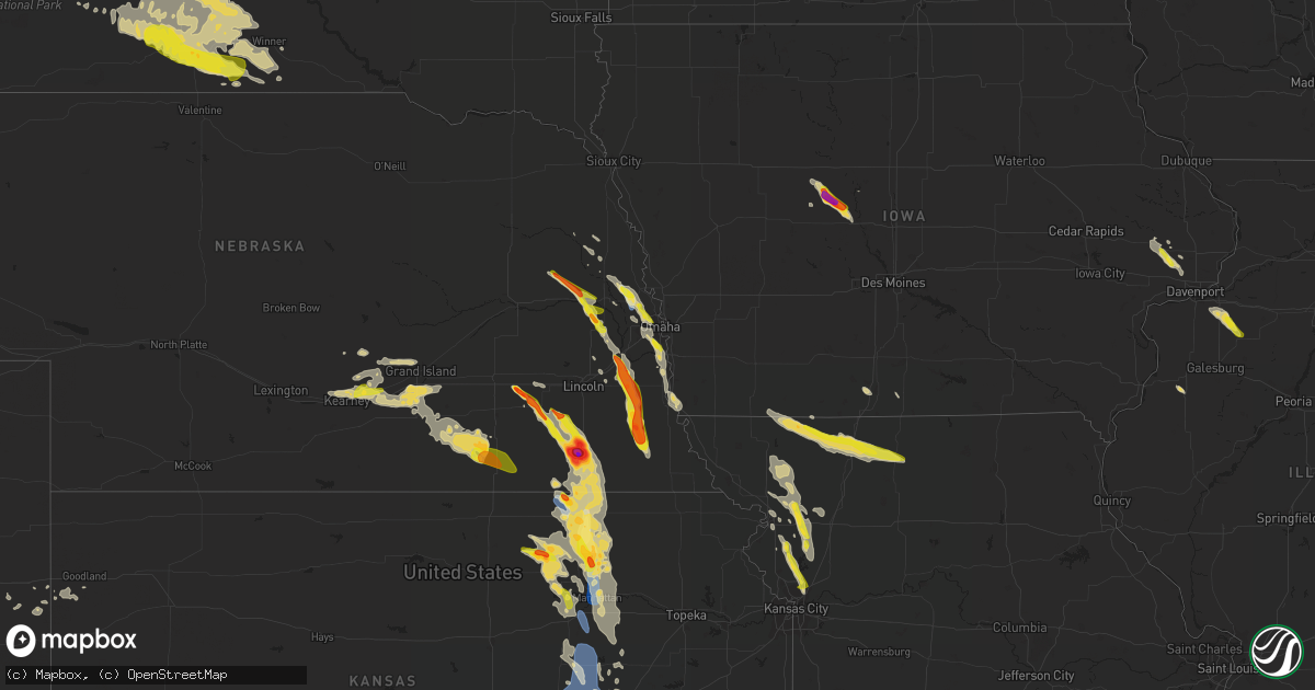
Hail Map on June 11, 2022
Get this storm
June 11 map
$229
one time, instant access
Download today. No call, no setup
Keep the $229
Bought the map and want the full workflow? Apply the entire $229 to a subscription within 7 days. None of it is wasted.
Every map, not just this one
This buys you this map. Subscription and you get every map we run, in the markets you choose from a few cities to whole states to nationwide. Plus real-time alerts the moment a storm fires.
Contact data
Name, contact info, occupancy, even credit band for addresses in the footprint. You go from where it hit to who to call.
Become the source they trust
Unlimited branding weather history reports on demand. You already have the documented answer ready for the property owner, and you are the one who showed up with it.
Property data and RoofTrace estimates
Pull up any address you have got, its value and the exact code rules for that jurisdiction, straight from One Click Code. Then RoofTrace estimates the squares, pitch, and roof value, priced the way you price.
States Impacted by Hail Map on June 11, 2022
Storm reports
Missouri
| Date | Description |
|---|---|
| 06/11/20226:42 AM CDT | At 1142 PM CDT, a severe thunderstorm was located over Courtney, moving southeast at 30 mph. HAZARD...60 mph wind gusts and quarter size hail. SOURCE...Radar indicated. IMPACT...Hail damage to vehicles is expected. Expect wind damage to roofs, siding, and trees. Locations impacted include... Kansas City, Independence, Lee's Summit, Blue Springs, Raytown, Liberty, Gladstone, Grain Valley, Excelsior Springs, Smithville, Kearney, Sugar Creek, Buckner, Claycomo, Courtney, Pleasant Valley, Lake Tapawingo, Glenaire, Sibley and Missouri City.This includes the following highways... Interstate 70 in Missouri between mile markers 7 and 28. Interstate 35 in Missouri between mile markers 10 and 28. Interstate 470 between mile markers 14 and 16. Interstate 435 between mile markers 41 and 64. |
| 06/11/20225:39 AM CDT | At 1038 PM CDT, a severe thunderstorm was located over Agency, or 8 miles southeast of St. Joseph, moving southeast at 25 mph. HAZARD...60 mph wind gusts and quarter size hail. SOURCE...Radar indicated. IMPACT...Hail damage to vehicles is expected. Expect wind damage to roofs, siding, and trees. Locations impacted include... Agency, Edgerton, Dearborn and Faucett. This includes Interstate 29 between mile markers 28 and 42. |
| 06/11/20225:26 AM CDT | At 1026 PM CDT, a severe thunderstorm was located near Plattsburg, moving south at 25 mph. HAZARD...60 mph wind gusts and quarter size hail. SOURCE...Radar indicated. IMPACT...Hail damage to vehicles is expected. Expect wind damage to roofs, siding, and trees. Locations impacted include... Smithville, Kearney, Lawson, Plattsburg, Lathrop, Gower, Stewartsville, Trimble, Holt, Easton and Turney.This includes Interstate 35 in Missouri between mile markers 28 and50. |
| 06/11/20225:00 AM CDT | At 1000 PM CDT, a severe thunderstorm was located near Plattsburg, moving southeast at 35 mph. HAZARD...60 mph wind gusts and half dollar size hail. SOURCE...Radar indicated. IMPACT...Hail damage to vehicles is expected. Expect wind damage to roofs, siding, and trees. Locations impacted include... Plattsburg, Lathrop, Gower, Stewartsville, Trimble, Holt, Osborn, Easton and Turney.This includes Interstate 35 in Missouri between mile markers 33 and46. |
| 06/11/20224:28 AM CDT | At 928 PM CDT, a severe thunderstorm was located near Clarksdale, or 8 miles west of Maysville, moving southeast at 50 mph. HAZARD...60 mph wind gusts and quarter size hail. SOURCE...Radar indicated. IMPACT...Hail damage to vehicles is expected. Expect wind damage to roofs, siding, and trees. Locations impacted include... Cameron, Maysville, Stewartsville, Union Star, Osborn, Clarksdale, Cosby, Amity and Helena.This includes Interstate 35 in Missouri between mile markers 53 and54. |
| 06/11/20223:56 AM CDT | At 856 PM CDT, a severe thunderstorm was located 7 miles southwest of Stanberry, moving southeast at 35 mph. HAZARD...60 mph wind gusts and quarter size hail. SOURCE...Radar indicated. IMPACT...Hail damage to vehicles is expected. Expect wind damage to roofs, siding, and trees. Locations impacted include... King City, Union Star, Bolckow, Guilford, Rea and Ford City. |
| 06/11/20223:21 AM CDT | At 821 PM CDT, a severe thunderstorm was located over Ridgeway, or 8 miles northeast of Bethany, moving east at 40 mph. HAZARD...60 mph wind gusts and quarter size hail. SOURCE...Radar indicated. IMPACT...Hail damage to vehicles is expected. Expect wind damage to roofs, siding, and trees. Locations impacted include... Bethany, Princeton, Ridgeway, Eagleville, Cainsville, Spickard, Blythedale, Mount Moriah, Modena and Mill Grove.This includes Interstate 35 in Missouri between mile markers 89 and106. |
| 06/11/20222:42 AM CDT | At 742 PM CDT, a severe thunderstorm was located near Grant City, or 17 miles southeast of Bedford, moving southeast at 40 mph. HAZARD...60 mph wind gusts and half dollar size hail. SOURCE...Radar indicated. IMPACT...Hail damage to vehicles is expected. Expect wind damage to roofs, siding, and trees. Locations impacted include... Bethany, Grant City, Ridgeway, Eagleville, New Hampton, Irena, Gentry, Worth, Allendale, Denver and Martinsville.This includes Interstate 35 in Missouri between mile markers 88 and106. |
| 06/11/20221:39 AM CDT | At 639 PM CDT, a severe thunderstorm was located 7 miles east of Union, or 9 miles northeast of Nebraska City, moving southeast at 40 mph. HAZARD...60 mph wind gusts and quarter size hail. SOURCE...Radar indicated. IMPACT...Hail damage to vehicles is expected. Expect wind damage to roofs, siding, and trees. This severe thunderstorm will be near... Nebraska City around 645 PM CDT. Sidney around 650 PM CDT. Riverton around 655 PM CDT.Other locations in the path of this severe thunderstorm includeHamburg.This includes Interstate 29 between mile markers 1 and 24. |
| 06/10/202211:30 PM CDT | A local report indicates 1.00 inch wind near 6 SSE SMITHVILLE |
| 06/10/202210:45 PM CDT | A local report indicates 60 MPH wind near 5 WNW HOLT |
| 06/10/202210:10 PM CDT | A local report indicates 1.00 inch wind near 2 SSW STEWARTSVILLE |
| 06/10/202210:07 PM CDT | A local report indicates 1.00 inch wind near STEWARTSVILLE |
| 06/10/202210:07 PM CDT | Social media photos of badly damaged pole barn. |
South Dakota
| Date | Description |
|---|---|
| 06/11/20226:52 AM CDT | At 1151 PM CDT/1051 PM MDT/, a severe thunderstorm was located near Midland, or 20 miles northeast of Kadoka, moving east at 65 mph. HAZARD...Golf ball size hail and 70 mph wind gusts. SOURCE...Trained weather spotters. IMPACT...People and animals outdoors will be injured. Expect hail damage to roofs, siding, windows, and vehicles. Expect considerable tree damage. Wind damage is also likely to mobile homes, roofs, and outbuildings. This severe thunderstorm will be near... Okaton around 1205 AM CDT.Other locations in the path of this severe thunderstorm includeMurdo, Draper and Westover. |
| 06/11/20226:27 AM CDT | At 1127 PM MDT, severe thunderstorms were located along a line extending from 3 miles east of Folsom to 8 miles southeast of Fairburn, moving east at 45 mph. HAZARD...60 mph wind gusts and quarter size hail. SOURCE...Radar indicated. IMPACT...Hail damage to vehicles is expected. Expect wind damage to roofs, siding, and trees. Severe thunderstorms will be near... Red Shirt Table Overlook around 1140 PM MDT. Scenic, Intersection of Red Shirt and Cuny Table Roads and Sheep Mountain Table around 1145 PM MDT.Other locations in the path of these severe thunderstorms includeLonesome Valley and Rockyford. |
| 06/11/20226:00 AM CDT | At 1100 PM MDT, a severe thunderstorm was located over southeastern Custer State Park, or 8 miles southeast of Custer, moving southeast at 45 mph. HAZARD...Ping pong ball size hail and 60 mph wind gusts. SOURCE...Radar indicated. IMPACT...People and animals outdoors will be injured. Expect hail damage to roofs, siding, windows, and vehicles. Expect wind damage to roofs, siding, and trees. This severe thunderstorm will be near... Buffalo Corrals around 1105 PM MDT. Fairburn around 1115 PM MDT. |
| 06/11/20225:46 AM CDT | At 1046 PM MDT/1146 PM CDT/, severe thunderstorms were located along a line extending from 4 miles south of Bunker to 8 miles northwest of Corn Creek to 4 miles southwest of Potato Creek, moving southeast at 65 mph. HAZARD...Golf ball size hail and 70 mph wind gusts. SOURCE...Radar indicated. IMPACT...People and animals outdoors will be injured. Expect hail damage to roofs, siding, windows, and vehicles. Expect considerable tree damage. Wind damage is also likely to mobile homes, roofs, and outbuildings. Locations impacted include... Mission, White River, Rosebud, Wanblee, Saint Francis, Parmelee, Okreek, Spring Creek, Long Valley, Norris, Midland, Wood, Belvidere, Carter, Cedar Butte, Mosher, Witten, Upper Cut Meat, Soldier Creek and Harrington.This includes Interstate 90 in South Dakota between Mile Markers 153and 174. |
| 06/11/20225:36 AM CDT | At 1036 PM MDT, severe thunderstorms were located along a line extending from near Tilford to 3 miles southwest of Hisega, moving east at 45 mph. HAZARD...60 mph wind gusts and quarter size hail. SOURCE...Radar indicated. IMPACT...Hail damage to vehicles is expected. Expect wind damage to roofs, siding, and trees. Severe thunderstorms will be near... Summerset around 1040 PM MDT. Black Hawk and Bear Country around 1045 PM MDT. Rapid City and Reptile Gardens around 1050 PM MDT. Rapid Valley, Ellsworth Air Force Base and Black Gap around 1055 PM MDT.Other locations in the path of these severe thunderstorms includeRapid City Airport, Caputa, Thompson Butte, New Underwood,Farmingdale and Viewfield.This includes Interstate 90 in South Dakota between Mile Markers 38and 93. |
| 06/11/20225:30 AM CDT | At 1030 PM MDT, a severe thunderstorm was located near Palmer Gulch Resort, or near Hill City, moving east at 50 mph. HAZARD...60 mph wind gusts and half dollar size hail. SOURCE...Radar indicated. IMPACT...Hail damage to vehicles is expected. Expect wind damage to roofs, siding, and trees. This severe thunderstorm will be near... Keystone, Keystone Wye, Mount Rushmore National Memorial and northern Custer State Park around 1035 PM MDT. Rockerville, Black Hills Playhouse, Center Lake and Bear Country around 1040 PM MDT. Hayward and Hart Ranch around 1045 PM MDT. Hermosa around 1050 PM MDT.Other locations in the path of this severe thunderstorm includeFolsom. |
| 06/11/20224:59 AM CDT | At 958 PM MDT, a severe thunderstorm was located 6 miles southwest of Four Corners, or 12 miles north of Newcastle, moving east at 55 mph. HAZARD...Golf ball size hail and 70 mph wind gusts. SOURCE...Radar indicated. IMPACT...People and animals outdoors will be injured. Expect hail damage to roofs, siding, windows, and vehicles. Expect considerable tree damage. Wind damage is also likely to mobile homes, roofs, and outbuildings. This severe thunderstorm will be near... Moon and Redbank Spring Campground around 1015 PM MDT.Other locations in the path of this severe thunderstorm includeMedicine Mountain, Bear Mountain Lookout, Hill City, Crazy HorseMemorial, Custer, Sylvan Lake, northwestern Custer State Park, BlackElk Peak, Palmer Gulch Resort, Horse Thief Lake, Keystone, MountRushmore National Memorial and Stockade Lake. |
| 06/11/20224:57 AM CDT | At 956 PM MDT, severe thunderstorms were located along a line extending from 12 miles south of Plainview to 7 miles north of Wall to 2 miles southeast of Farmingdale, moving southeast at 55 mph. HAZARD...Golf ball size hail and 70 mph wind gusts. SOURCE...Radar indicated. IMPACT...People and animals outdoors will be injured. Expect hail damage to roofs, siding, windows, and vehicles. Expect considerable tree damage. Wind damage is also likely to mobile homes, roofs, and outbuildings. Severe thunderstorms will be near... Wall around 1005 PM MDT. Quinn and Delta 9 Missile Silo around 1010 PM MDT.Other locations in the path of these severe thunderstorms includeScenic, Cottonwood, Delta 1 Launch Facility, Grindstone Butte, CactusFlat, Minuteman Missile Visitors Center, Kadoka and Intersection ofHighway 73 and White River.This includes Interstate 90 in South Dakota between Mile Markers 81and 155. |
| 06/11/20224:35 AM CDT | At 935 PM MDT, a severe thunderstorm was located 3 miles northeast of New Underwood, or 23 miles east of Rapid City, moving southeast at 55 mph. HAZARD...70 mph wind gusts. SOURCE...Radar indicated. IMPACT...Expect considerable tree damage. Damage is likely to mobile homes, roofs, and outbuildings. This severe thunderstorm will be near... Owanka around 950 PM MDT.Other locations in the path of this severe thunderstorm includenorthern Badlands National Park.This includes Interstate 90 in South Dakota between Mile Markers 65and 86. |
| 06/11/20224:08 AM CDT | At 908 PM MDT, a severe thunderstorm was located over New Haven, or 32 miles northwest of Sundance, moving east at 60 mph. HAZARD...Golf ball size hail and 70 mph wind gusts. SOURCE...Radar indicated. IMPACT...People and animals outdoors will be injured. Expect hail damage to roofs, siding, windows, and vehicles. Expect considerable tree damage. Wind damage is also likely to mobile homes, roofs, and outbuildings. This severe thunderstorm will be near... Hulett around 920 PM MDT. Alva around 925 PM MDT.Other locations in the path of this severe thunderstorm include CookLake, Bear Lodge Campground, Aladdin and Beulah.This includes Interstate 90 in Wyoming between Mile Markers 195 and206. |
| 06/11/20223:58 AM CDT | At 858 PM MDT, a severe thunderstorm was located 12 miles southeast of Owl Butte, or 24 miles northeast of Sturgis, moving east at 60 mph. HAZARD...Golf ball size hail and 70 mph wind gusts. SOURCE...Radar indicated. IMPACT...People and animals outdoors will be injured. Expect hail damage to roofs, siding, windows, and vehicles. Expect considerable tree damage. Wind damage is also likely to mobile homes, roofs, and outbuildings. Locations impacted include... Union Center, Elm Springs and Creighton.This includes Interstate 90 in South Dakota between Mile Markers 85and 113. |
| 06/11/20223:36 AM CDT | At 836 PM MDT, a severe thunderstorm was located 4 miles west of Newell Lake, or 22 miles northeast of Belle Fourche, moving east at 50 mph. HAZARD...80 mph wind gusts and ping pong ball size hail. SOURCE...Radar indicated. IMPACT...Flying debris will be dangerous to those caught without shelter. Mobile homes will be heavily damaged. Expect considerable damage to roofs, windows, and vehicles. Extensive tree damage and power outages are likely. This severe thunderstorm will be near... Newell Lake around 840 PM MDT. |
| 06/11/20223:13 AM CDT | At 812 PM MDT, a severe thunderstorm was located 9 miles southeast of Colony, or 11 miles northwest of Belle Fourche, moving east at 50 mph. THIS IS A DESTRUCTIVE STORM FOR BELLE FOURCHE AND BELLE FOURCHE RESERVOIR. HAZARD...Three inch hail and 60 mph wind gusts. SOURCE...Radar indicated. IMPACT...People and animals outdoors will be severely injured. Expect shattered windows, extensive damage to roofs, siding, and vehicles. This severe thunderstorm will be near... Belle Fourche and Belle Fourche Reservoir around 825 PM MDT. Fruitdale and Arpan around 830 PM MDT.Other locations in the path of this severe thunderstorm includeNisland, Newell, Vale and Owl Butte. |
| 06/11/20222:02 AM CDT | Time estimated from radar |
| 06/11/202212:59 AM CDT | Mesonet station 13 vivian |
| 06/11/202212:25 AM CDT | A local report indicates 61 MPH wind near 1 SSE WHITE RIVER |
| 06/11/202212:07 AM CDT | A local report indicates 58 MPH wind near 3 WSW FAIRBURN |
| 06/11/202212:02 AM CDT | A local report indicates 64 MPH wind near 1 NE MIDLAND |
| 06/11/202212:00 AM CDT | A local report indicates 1.75 inch wind near 5 W HERMOSA |
| 06/10/202211:55 PM CDT | A local report indicates 1.00 inch wind near 5 WNW HERMOSA |
| 06/10/202211:46 PM CDT | A local report indicates 1.75 inch wind near MOUNT RUSHMORE |
| 06/10/202211:45 PM CDT | A local report indicates 1.00 inch wind near KEYSTONE |
| 06/10/202211:32 PM CDT | A local report indicates 1.50 inch wind near HILL CITY |
| 06/10/202211:30 PM CDT | Widespread wind damage in philip with damage to several buildings in town |
| 06/10/202211:28 PM CDT | A local report indicates 1.50 inch wind near HILL CITY |
| 06/10/202211:25 PM CDT | A local report indicates 63 MPH wind near 2 E COTTONWOOD |
| 06/10/202211:23 PM CDT | A local report indicates 66 MPH wind near 4 E CACTUS FLAT |
| 06/10/202210:59 PM CDT | A local report indicates 70 MPH wind near 3 NW WASTA |
| 06/10/202210:20 PM CDT | A local report indicates 66 MPH wind near 1 SW NEWELL |
| 06/10/202210:10 PM CDT | A local report indicates 2.00 inch wind near 17 E STURGIS |
| 06/10/202210:05 PM CDT | A local report indicates 80 MPH wind near 7 E STURGIS |
| 06/10/202210:00 PM CDT | A local report indicates 66 MPH wind near 1 SW NEWELL |
| 06/10/20229:48 PM CDT | A local report indicates 1.25 inch wind near 2 W VALE |
| 06/10/20229:48 PM CDT | A local report indicates 1.25 inch wind near 2 WSW VALE |
| 06/10/20229:45 PM CDT | A local report indicates 2.00 inch wind near 2 SE NISLAND |
| 06/10/20229:45 PM CDT | A local report indicates 1.25 inch wind near 13 N STURGIS |
| 06/10/20229:40 PM CDT | A local report indicates 1.00 inch wind near NISLAND |
| 06/10/20229:40 PM CDT | Several large cottonwood trees down and other trees down in the shelter belt. |
| 06/10/20229:40 PM CDT | A local report indicates 1.50 inch wind near NISLAND |
| 06/10/20229:30 PM CDT | Tree and deck damage |
| 06/10/20229:30 PM CDT | A local report indicates 1.50 inch wind near BELLE FOURCHE RESV |
| 06/10/20229:27 PM CDT | A local report indicates 92 MPH wind near 12 WSW CASTLE ROCK |
| 06/10/20229:25 PM CDT | A local report indicates 2.00 inch wind near 6 N BELLE FOURCHE |
| 06/10/20229:21 PM CDT | A local report indicates 73 MPH wind near 2 N BELLE FOURCHE |
| 06/10/20229:05 PM CDT | A local report indicates 1.00 inch wind near COLONY |
Florida
| Date | Description |
|---|---|
| 06/11/20223:54 PM CDT | Trees reported down at dufferin street and radio road. |
| 06/10/202211:46 PM CDT | At 445 PM EDT, a severe thunderstorm was located over Saint Augustine, moving east at 15 mph. HAZARD...60 mph wind gusts and penny size hail. SOURCE...Radar indicated. IMPACT...Expect damage to roofs, siding, and trees. Locations impacted include... Saint Augustine, Saint Augustine Beach, Saint Augustine Shores, Butler Beach, Vilano Beach, Saint Augustine South and Anastasia. |
Louisiana
| Date | Description |
|---|---|
| 06/11/20227:23 AM CDT | At 1223 PM CDT, severe thunderstorms were located along a line extending from near Newellton to near Cooter Point, moving southeast at 50 mph. HAZARD...60 mph wind gusts and penny size hail. SOURCE...Radar indicated. IMPACT...Expect damage to roofs, siding, and trees. Severe thunderstorms will be near... Alcorn around 1230 PM CDT. Port Gibson around 1235 PM CDT. Lorman around 1240 PM CDT. Pattison and Red Lick around 1245 PM CDT. Church Hill around 1250 PM CDT. Mcbride, Blue Hill and Peyton around 1255 PM CDT. Fayette, Stampley and Union Church around 100 PM CDT. Mcnair around 105 PM CDT. |
| 06/11/20226:51 AM CDT | At 1151 AM CDT, a severe thunderstorm was located near Winnsboro, moving southeast at 35 mph. HAZARD...60 mph wind gusts and nickel size hail. SOURCE...Radar indicated. IMPACT...Expect damage to roofs, siding, and trees. This severe thunderstorm will be near... Winnsboro and Crowville around 1155 AM CDT. Wisner around 1215 PM CDT.Other locations impacted by this severe thunderstorm include Gilbertand Baskin. |
Wyoming
| Date | Description |
|---|---|
| 06/11/20223:54 AM CDT | At 853 PM MDT, a severe thunderstorm was located 5 miles west of Rozet, or 9 miles east of Gillette, moving east at 40 mph. Another severe storm was located near Moorcroft, also moving east. HAZARD...60 mph wind gusts and half dollar size hail. SOURCE...Radar indicated. IMPACT...Hail damage to vehicles is expected. Expect wind damage to roofs, siding, and trees. This severe thunderstorm will be near... Rozet around 900 PM MDT.Other locations in the path of this severe thunderstorm includeMoorcroft, southern Keyhole Reservoir, Pine Haven and Upton.This includes Interstate 90 in Wyoming between Mile Markers 133 and186. |
| 06/11/20221:44 AM CDT | At 643 PM MDT, a severe thunderstorm was located near Biddle, or 19 miles south of Broadus, moving east southeast at 50 mph. HAZARD...Golf ball size hail and 60 mph wind gusts, along with very heavy rain. SOURCE...Radar indicated. IMPACT...People and animals outdoors will be injured. Expect hail damage to roofs, siding, windows, and vehicles. Expect wind damage to roofs, siding, and trees. Locations impacted include... Alzada, Biddle, Belle Creek and Ridge. This replaces the warning previously in effect for this area. |
| 06/11/202212:45 AM CDT | At 543 PM MDT, a severe thunderstorm was located 14 miles south of Ashland, or 37 miles southeast of Colstrip, moving east southeast at 45 mph. The strongest portion of this storm is expected to remain south of US-212. HAZARD...Ping pong ball size hail and 60 mph wind gusts, along with heavy rain. SOURCE...Radar indicated. IMPACT...People and animals outdoors will be injured. Expect hail damage to roofs, siding, windows, and vehicles. Expect wind damage to roofs, siding, and trees. Locations impacted include... Broadus, Biddle and Sonnette. |
| 06/10/202210:38 PM CDT | A local report indicates 1.00 inch wind near 5 NNE UPTON |
| 06/10/202210:22 PM CDT | A local report indicates 1.00 inch wind near 1 NNE HULETT |
Oregon
| Date | Description |
|---|---|
| 06/11/20222:10 PM CDT | Pendleton atc tower relayed report from a pilot south of airfield... Of observing debris and dust being picked up by a small tornado. Initial funnel cloud was observed |
Kansas
| Date | Description |
|---|---|
| 06/11/20226:58 PM CDT | A local report indicates 70 MPH wind near 5 S OLSBURG |
| 06/11/20226:40 PM CDT | 12 inch tree limb down as well as multiple smaller limbs as well. |
| 06/11/20226:31 PM CDT | Report from mping: 3-inch tree limbs broken; power poles broken. |
| 06/11/20226:30 PM CDT | Delayed report from mping: trees uprooted or snapped; roof blown off. |
| 06/11/20226:30 PM CDT | Highway 77 closed west of blue rapids due to power lines down along the road. |
| 06/11/20226:25 PM CDT | Ksu mesonet observation. |
| 06/11/20226:24 PM CDT | Report from mping: 3-inch tree limbs broken; power poles broken. |
| 06/11/20226:20 PM CDT | Delayed report from social media... Damage to farm buildings. Time estimated. |
| 06/11/20226:11 PM CDT | Reports of 4 industrial buildings collapsed and power lines down in marysville. Highway 36 has been closed due to debris covering the road. Time estimated from radar. |
| 06/11/20226:08 PM CDT | Delayed report. |
| 06/11/20226:05 PM CDT | A local report indicates 1.50 inch wind near 5 N HANOVER |
| 06/11/20226:03 PM CDT | Report from mping: quarter |
| 06/11/20226:01 PM CDT | Debris along north street in marysville. Many trees down along north street. |
| 06/11/20225:59 PM CDT | Rain wrapped tornado near highway 77. |
| 06/11/20225:54 PM CDT | Reports of tornado on the ground. |
| 06/11/20226:23 AM CDT | At 1123 PM CDT, severe thunderstorms were located along a line extending from 3 miles southwest of Independence to 3 miles northwest of Caney, moving south at 50 mph. HAZARD...60 mph wind gusts and quarter size hail. SOURCE...Radar indicated. IMPACT...Hail damage to vehicles is expected. Expect wind damage to roofs, siding, and trees. Locations in or near the path include... Bartlesville... Nowata... Dewey... South Coffeyville... Copan... Ramona... Ochelata... Delaware... Lenapah... Wann... New Alluwe... Watova... |
| 06/11/20226:06 AM CDT | At 1105 PM CDT, a severe thunderstorm was located near Kearney, moving south at 40 mph. HAZARD...70 mph wind gusts and quarter size hail. SOURCE...Radar indicated. IMPACT...Hail damage to vehicles is expected. Expect considerable tree damage. Wind damage is also likely to mobile homes, roofs, and outbuildings. Locations impacted include... Kansas City, Independence, Liberty, Gladstone, Smithville, Kearney, Parkville, Platte City, North Kansas City, Sugar Creek, Riverside, Weatherby Lake, Claycomo, Courtney, Pleasant Valley, Lake Waukomis, Trimble, Edgerton, Glenaire and Dearborn.This includes the following highways... Interstate 35 in Missouri between mile markers 7 and 32. Interstate 29 between mile markers 0 and 18. Interstate 635 between mile markers 11 and 12. Interstate 435 near mile marker 21, and between mile markers 23 and55. |
| 06/11/20225:58 AM CDT | At 1058 PM CDT, severe thunderstorms were located along a line extending from near Elk City to 7 miles northeast of Sedan to 8 miles southeast of Grenola, moving south at 35 mph. HAZARD...60 mph wind gusts and nickel size hail. SOURCE...Radar indicated. IMPACT...Expect damage to roofs, siding, and trees. Locations impacted include... Coffeyville, Independence, Caney, Sedan, Dearing, Elk City, Tyro, Peru, Chautauqua, Havana, Elgin, Bolton, Niotaze, Elk City Lake, Elk City State Park, Hale and Independence Airport. |
| 06/11/20225:29 AM CDT | At 1029 PM CDT, severe thunderstorms were located along a line extending from near Fall River to Howard to 9 miles southeast of Latham, moving south at 45 mph. HAZARD...70 mph wind gusts and quarter size hail. SOURCE...Radar indicated. IMPACT...Hail damage to vehicles is expected. Expect considerable tree damage. Wind damage is also likely to mobile homes, roofs, and outbuildings. Locations impacted include... Howard, Moline, Longton, Elk City, Grenola, Elk Falls, Hale, Buxton and Elk City Lake. |
| 06/11/20224:51 AM CDT | At 950 PM CDT, severe thunderstorms were located along a line extending from near Hamilton to 13 miles west of Eureka to near El Dorado, moving southeast at 45 mph. HAZARD...70 mph wind gusts and quarter size hail. SOURCE...Radar indicated. IMPACT...Hail damage to vehicles is expected. Expect considerable tree damage. Wind damage is also likely to mobile homes, roofs, and outbuildings. Locations impacted include... El Dorado, Eureka, Leon, Severy, Fall River, Latham, Rosalia, Climax, New Albany, Eureka Airport, Fall River State Park, El Dorado Airport, Beaumont, Fall River Lake, Piedmont, El Dorado State Park and El Dorado Lake.This includes Interstate 35 between Mile Markers 71 and 73. |
| 06/11/20224:14 AM CDT | At 913 PM CDT, severe thunderstorms were located along a line extending from 7 miles southwest of Olpe to 12 miles south of Cottonwood Falls to 5 miles east of Florence, moving south at 50 mph. HAZARD...60 mph wind gusts and half dollar size hail. SOURCE...Radar indicated. IMPACT...Hail damage to vehicles is expected. Expect wind damage to roofs, siding, and trees. Locations impacted include... El Dorado, Eureka, Marion, Cottonwood Falls, Madison, Strong City, Florence, Hamilton, Burns, Cassoday, Bazaar, Elmdale, Matfield Green, Cedar Point, Eureka City Lake, El Dorado State Park, Thrall, Eureka Airport, Wonsevu and Tallgrass Prairie.This includes Interstate 35 between Mile Markers 72 and 115. |
| 06/11/20223:52 AM CDT | At 852 PM CDT, a severe thunderstorm was located 9 miles west of Emporia, moving south at 30 mph. HAZARD...60 mph wind gusts and quarter size hail. SOURCE...Radar indicated. IMPACT...Hail damage to vehicles is expected. Expect wind damage to roofs, siding, and trees. This severe thunderstorm will remain over mainly rural areas of southwestern Lyon County.This includes Kansas Turnpike between mile markers 117 and 125. |
| 06/11/20223:29 AM CDT | At 829 PM CDT, a severe thunderstorm was located near Council Grove, moving south at 35 mph. HAZARD...70 mph wind gusts and quarter size hail. SOURCE...Radar indicated. IMPACT...Hail damage to vehicles is expected. Expect considerable tree damage. Wind damage is also likely to mobile homes, roofs, and outbuildings. Locations impacted include... Council Grove, Americus, White City, Alta Vista, Dwight, Allen, Wilsey, Parkerville, Bushong, Dunlap and Council Grove Lake. |
| 06/11/20223:09 AM CDT | At 809 PM CDT, severe thunderstorms were located along a line extending from 9 miles northwest of Bushong to Wilsey to near Woodbine, moving south at 45 mph. HAZARD...70 mph wind gusts and ping pong ball size hail. SOURCE...Radar indicated. IMPACT...People and animals outdoors will be injured. Expect hail damage to roofs, siding, windows, and vehicles. Expect considerable tree damage. Wind damage is also likely to mobile homes, roofs, and outbuildings. Locations impacted include... Marion, Cottonwood Falls, Strong City, Florence, Burns, Lincolnville, Bazaar, Lost Springs, Elmdale, Matfield Green, Cedar Point, Hymer, Wonsevu, Tallgrass Prairie, Saffordville and Tallgrass Prairie Preserve.This includes Interstate 35 between Mile Markers 97 and 115. |
| 06/11/20222:53 AM CDT | At 753 PM CDT, a severe thunderstorm was located over Wakefield, moving south at 30 mph. HAZARD...Ping pong ball size hail and 60 mph wind gusts. SOURCE...Radar indicated. IMPACT...People and animals outdoors will be injured. Expect hail damage to roofs, siding, windows, and vehicles. Expect wind damage to roofs, siding, and trees. Locations impacted include... Southwestern Manhattan, Junction City, Ogden, Wakefield, Riley, Milford, Leonardville and Milford Lake. |
| 06/11/20222:42 AM CDT | At 742 PM CDT, a severe thunderstorm was located 5 miles southeast of Clay Center, moving south at 25 mph. HAZARD...Ping pong ball size hail and 60 mph wind gusts. SOURCE...Radar indicated. IMPACT...People and animals outdoors will be injured. Expect hail damage to roofs, siding, windows, and vehicles. Expect wind damage to roofs, siding, and trees. Locations impacted include... Clay Center and Green. |
| 06/11/20222:39 AM CDT | At 739 PM CDT, a severe thunderstorm was located 5 miles west of Volland, moving south at 40 mph. HAZARD...70 mph wind gusts and ping pong ball size hail. SOURCE...Radar indicated. IMPACT...People and animals outdoors will be injured. Expect hail damage to roofs, siding, windows, and vehicles. Expect considerable tree damage. Wind damage is also likely to mobile homes, roofs, and outbuildings. Locations impacted include... Manhattan, Wamego, Council Grove, Alma, Eskridge, Ogden, Grandview Plaza, St. George, White City, Alta Vista, Dwight, McFarland, Paxico, Allen, Admire, Wilsey, Parkerville, Bushong, Dunlap and Council Grove Lake.This includes Interstate 70 between mile markers 301 and 334. |
| 06/11/20222:09 AM CDT | At 709 PM CDT, severe thunderstorms were located along a line extending from 9 miles southwest of Barnes to near Morganville, moving southeast at 20 mph. HAZARD...Ping pong ball size hail and 60 mph wind gusts. SOURCE...Radar indicated. IMPACT...People and animals outdoors will be injured. Expect hail damage to roofs, siding, windows, and vehicles. Expect wind damage to roofs, siding, and trees. Locations impacted include... Clay Center, Wakefield, Clifton, Morganville, Green, Palmer, Vining and Idana. |
| 06/11/20221:59 AM CDT | At 659 PM CDT, severe thunderstorms were located along a line extending from 3 miles east of Leonardville to 4 miles east of Olsburg, moving south at 35 mph. HAZARD...Two inch hail and 70 mph wind gusts. SOURCE...Radar indicated. IMPACT...People and animals outdoors will be injured. Expect hail damage to roofs, siding, windows, and vehicles. Expect considerable tree damage. Wind damage is also likely to mobile homes, roofs, and outbuildings. Locations impacted include... Manhattan, Junction City, Wamego, Westmoreland, Ogden, Grandview Plaza, Riley, St. George, Milford, Leonardville, Olsburg, Louisville, Randolph, Milford Lake, Keats and Tuttle Creek Lake.This includes Interstate 70 between mile markers 290 and 326. |
| 06/11/20221:52 AM CDT | At 650 PM CDT, severe thunderstorms were located along a line extending from 4 miles east of Linn to 5 miles south of Vining, moving southeast at 25 mph. HAZARD...Ping pong ball size hail and 60 mph wind gusts. SOURCE...Radar indicated. IMPACT...People and animals outdoors will be injured. Expect hail damage to roofs, siding, windows, and vehicles. Expect wind damage to roofs, siding, and trees. Locations impacted include... Clay Center, Clifton, Morganville, Green, Palmer, Vining and Idana. |
| 06/11/20221:27 AM CDT | At 626 PM CDT, a severe thunderstorm was located over Blue Rapids, moving south at 30 mph. HAZARD...Two inch hail and 70 mph wind gusts. SOURCE...Radar indicated. IMPACT...People and animals outdoors will be injured. Expect hail damage to roofs, siding, windows, and vehicles. Expect considerable tree damage. Wind damage is also likely to mobile homes, roofs, and outbuildings. Locations impacted include... Marysville, Blue Rapids, Westmoreland, Blaine, Frankfort, Waterville, Greenleaf, Olsburg, Randolph and Barnes. |
| 06/11/202212:57 AM CDT | At 557 PM CDT, a severe thunderstorm was located over Hanover, moving southeast at 20 mph. HAZARD...Golf ball size hail and 70 mph wind gusts. SOURCE...Radar indicated. IMPACT...People and animals outdoors will be injured. Expect hail damage to roofs, siding, windows, and vehicles. Expect considerable tree damage. Wind damage is also likely to mobile homes, roofs, and outbuildings. Locations impacted include... Hanover, Barnes, Hollenberg and Bremen. |
| 06/11/202212:09 AM CDT | At 509 PM CDT, a severe thunderstorm was located 6 miles east of Wymore, moving southeast at 20 mph. HAZARD...Two inch hail and 60 mph wind gusts. SOURCE...Radar indicated. IMPACT...People and animals outdoors will be injured. Expect hail damage to roofs, siding, windows, and vehicles. Expect wind damage to roofs, siding, and trees. Locations impacted include... Summerfield. |
| 06/10/202210:30 PM CDT | Major tree damage. |
| 06/10/202210:15 PM CDT | Large tree limbs down and power is out across much of town. |
| 06/10/202210:07 PM CDT | Personal weather station. |
| 06/10/20229:53 PM CDT | A local report indicates 70 MPH wind near THRALL |
| 06/10/20229:44 PM CDT | A local report indicates 75 MPH wind near 8 W MADISON |
| 06/10/20229:44 PM CDT | A local report indicates 60 MPH wind near 4 NW THRALL |
| 06/10/20229:40 PM CDT | A local report indicates 60 MPH wind near 9 NNE EL DORADO |
| 06/10/20229:30 PM CDT | A local report indicates 65 MPH wind near 4 E MATFIELD GREEN |
| 06/10/20229:20 PM CDT | A local report indicates 60 MPH wind near 7 N MATFIELD GREEN |
| 06/10/20229:10 PM CDT | A local report indicates 61 MPH wind near 4 NNW FLORENCE |
| 06/10/20229:05 PM CDT | Power poles and power line damage. |
| 06/10/20229:05 PM CDT | Delayed report. Time estimated from radar. |
| 06/10/20228:16 PM CDT | Report from mping: quarter |
| 06/10/20228:08 PM CDT | A local report indicates 1.00 inch wind near 5 SSE MILFORD |
| 06/10/20228:00 PM CDT | A local report indicates 1.00 inch wind near 2 SE MILFORD |
| 06/10/20227:53 PM CDT | Delayed report. Time estimated from radar. Numerous trees and power lines down. |
| 06/10/20227:47 PM CDT | Awos station kfri ft riley marshal. |
| 06/10/20227:45 PM CDT | A local report indicates 1.00 inch wind near 5 NW ALMA |
| 06/10/20227:37 PM CDT | Report from mping: 3-inch tree limbs broken; power poles broken. |
| 06/10/20227:27 PM CDT | Large tree uprooted... Several large branches down east end of ogden. Delayed report... Time estimated from radar. |
| 06/10/20227:26 PM CDT | A local report indicates 80 MPH wind near MANHATTAN |
| 06/10/20227:26 PM CDT | 5 inch tree limbs down as well as debris in the streets. |
| 06/10/20227:25 PM CDT | Corrects time of previous tstm wnd gst report from 2 nnw manhattan. Ksu mesonet observation. |
| 06/10/20227:21 PM CDT | A local report indicates 1.75 inch wind near 5 NE MORGANVILLE |
| 06/10/20227:20 PM CDT | Social media picture showing damage to the chi omega... Kappa alpha chapter building in manhattan. Time estimated from radar. Unknown if straight-line winds or tornado. |
| 06/10/20227:19 PM CDT | Measured via accuride. |
| 06/10/20227:01 PM CDT | A local report indicates 1.75 inch wind near OLSBURG |
Nebraska
| Date | Description |
|---|---|
| 06/11/20226:55 PM CDT | Tree limbs broken. Shingles blown off roof. |
| 06/11/20226:10 PM CDT | Shingles blown off roof. |
| 06/11/20226:08 PM CDT | Nickel to quarter sized hail on south side of bellevue. Time estimated from radar. Relayed via social media. |
| 06/11/20226:01 PM CDT | Corrects previous tstm wnd gst report from 1 sw papillion. Trained storm spotter measured a peak wind gust of 53 knots. |
| 06/11/20225:56 PM CDT | Report for quarter sized hail. |
| 06/11/20225:43 PM CDT | Quarter |
| 06/11/20225:40 PM CDT | A local report indicates 1.00 inch wind near 1 S ASHLAND |
| 06/11/20225:33 PM CDT | Trees and powerlines down. Time estimated from radar. |
| 06/11/20225:24 PM CDT | Extensive tree damage around wymore. |
| 06/11/20225:23 PM CDT | A local report indicates a tornado near 2 SE WYMORE |
| 06/11/20225:18 PM CDT | Trained spotter reported brief touch down of tornado east of blue springs. |
| 06/11/20224:54 PM CDT | Quarter |
| 06/11/20224:39 PM CDT | Report from mping: baseball+ |
| 06/11/20224:36 PM CDT | A local report indicates 1.00 inch wind near CEDAR BLUFFS |
| 06/11/20224:33 PM CDT | Time estimated by radar. |
| 06/11/20224:29 PM CDT | Grapefruit- |
| 06/11/20224:28 PM CDT | Photo sent to broadcast media. |
| 06/11/20224:27 PM CDT | A local report indicates 3.75 inch wind near 1 N BEATRICE |
| 06/11/20224:23 PM CDT | Corrects previous hail report from 1 n beatrice. |
| 06/11/20224:10 PM CDT | Public reported golf ball sized hail via social media. |
| 06/11/20226:58 AM CDT | 50mph winds and ping pong sized hail. |
| 06/11/20225:30 AM CDT | A local report indicates 1.00 inch wind near 7 NNW GIBBON |
| 06/11/20221:58 AM CDT | At 657 PM CDT, a severe thunderstorm was located 5 miles southwest of Johnson, or 5 miles east of Tecumseh, moving south at 40 mph. HAZARD...Ping pong ball size hail and 60 mph wind gusts. SOURCE...Radar indicated. IMPACT...People and animals outdoors will be injured. Expect hail damage to roofs, siding, windows, and vehicles. Expect wind damage to roofs, siding, and trees. This severe thunderstorm will be near... Table Rock around 715 PM CDT.Other locations in the path of this severe thunderstorm includeHumboldt. |
| 06/11/20221:12 AM CDT | At 611 PM CDT, a severe thunderstorm was located near Syracuse, or 17 miles west of Nebraska City, moving south at 40 mph. HAZARD...Ping pong ball size hail and 60 mph wind gusts. SOURCE...Radar indicated. This storm has a history of producing quarter sized hail. IMPACT...People and animals outdoors will be injured. Expect hail damage to roofs, siding, windows, and vehicles. Expect wind damage to roofs, siding, and trees. This severe thunderstorm will be near... Syracuse around 615 PM CDT. Lorton around 625 PM CDT. Cook around 630 PM CDT.Other locations in the path of this severe thunderstorm includeTalmage, Brock and Johnson. |
| 06/11/20221:07 AM CDT | At 607 PM CDT, a severe thunderstorm was located near Offutt AFB, moving southeast at 40 mph. HAZARD...Ping pong ball size hail and 60 mph wind gusts. SOURCE...Radar indicated. IMPACT...People and animals outdoors will be injured. Expect hail damage to roofs, siding, windows, and vehicles. Expect wind damage to roofs, siding, and trees. This severe thunderstorm will be near... Plattsmouth, Glenwood and Pacific Junction around 615 PM CDT. Beaver Lake around 620 PM CDT.Other locations in the path of this severe thunderstorm includeTabor.This includes Interstate 29 between mile markers 17 and 42. |
| 06/11/202212:51 AM CDT | At 550 PM CDT, a severe thunderstorm was located 4 miles west of Barneston, or 13 miles north of Marysville, moving southeast at 35 mph. HAZARD...Quarter size hail. SOURCE...Radar indicated. IMPACT...Damage to vehicles is expected. This severe thunderstorm will remain over mainly rural areas of south central Gage County. |
| 06/11/202212:25 AM CDT | At 524 PM CDT, a severe thunderstorm was located 3 miles north of Bennington, moving southeast at 30 mph. HAZARD...Ping pong ball size hail and 60 mph wind gusts. SOURCE...Radar indicated. IMPACT...People and animals outdoors will be injured. Expect hail damage to roofs, siding, windows, and vehicles. Expect wind damage to roofs, siding, and trees. This severe thunderstorm will be near... Omaha and Flanagan Lake around 535 PM CDT. Standing Bear Lake around 540 PM CDT.Other locations in the path of this severe thunderstorm include BoysTown, Benson, Aksarben, Florence, Ralston, La Vista, Carter Lake,Midtown, Eppley Airfield, Council Bluffs, Papillion, South Omaha,Bellevue and Offutt AFB.People attending Westfair Fairground & Amphitheater should seek safeshelter immediately!This includes the following highways... Interstate 29 between mile markers 42 and 63. Interstate 80 in Iowa between mile markers 1 and 11. Interstate 80 in Nebraska between mile markers 439 and 454. |
| 06/11/202212:06 AM CDT | At 505 PM CDT, a severe thunderstorm was located 5 miles south of Gretna, moving southeast at 35 mph. HAZARD...Ping pong ball size hail and 60 mph wind gusts. SOURCE...Public. This storm has a history of producing quarter sized hail. IMPACT...People and animals outdoors will be injured. Expect hail damage to roofs, siding, windows, and vehicles. Expect wind damage to roofs, siding, and trees. This severe thunderstorm will be near... Springfield around 510 PM CDT. Louisville, Cedar Creek and Murdock around 515 PM CDT.This includes Interstate 80 in Nebraska between mile markers 418 and437. |
| 06/10/202211:38 PM CDT | At 437 PM CDT, a severe thunderstorm was located 4 miles north of Mead, or 7 miles northeast of Wahoo, moving southeast at 30 mph. HAZARD...Ping pong ball size hail and 60 mph wind gusts. SOURCE...Radar indicated. IMPACT...People and animals outdoors will be injured. Expect hail damage to roofs, siding, windows, and vehicles. Expect wind damage to roofs, siding, and trees. This severe thunderstorm will be near... Valley around 445 PM CDT. Yutan and Ithaca around 450 PM CDT. Waterloo around 455 PM CDT.Other locations in the path of this severe thunderstorm includeGretna and Ashland.This includes Interstate 80 in Nebraska between mile markers 428 and435. |
| 06/10/202211:25 PM CDT | At 424 PM CDT, a severe thunderstorm was located 3 miles north of Friend, or 17 miles southwest of Seward, moving southeast at 10 mph. HAZARD...Two inch hail and 60 mph wind gusts. SOURCE...Radar indicated. IMPACT...People and animals outdoors will be injured. Expect hail damage to roofs, siding, windows, and vehicles. Expect wind damage to roofs, siding, and trees. This severe thunderstorm will be near... Friend around 435 PM CDT.Other locations in the path of this severe thunderstorm includeDorchester. |
| 06/10/202211:04 PM CDT | At 404 PM CDT, a severe thunderstorm was located 5 miles north of Cedar Bluffs, or 6 miles northwest of Fremont, moving southeast at 35 mph. HAZARD...Ping pong ball size hail and 60 mph wind gusts. SOURCE...Radar indicated. IMPACT...People and animals outdoors will be injured. Expect hail damage to roofs, siding, windows, and vehicles. Expect wind damage to roofs, siding, and trees. This severe thunderstorm will be near... Fremont, Inglewood and Woodcliff around 415 PM CDT.Other locations in the path of this severe thunderstorm includeArlington, Leshara and Valley. |
| 06/10/202211:03 PM CDT | At 403 PM CDT, a severe thunderstorm was located 5 miles southwest of Pickrell, or 5 miles northwest of Beatrice, moving east at 30 mph. HAZARD...Ping pong ball size hail and 60 mph wind gusts. SOURCE...Radar indicated. IMPACT...People and animals outdoors will be injured. Expect hail damage to roofs, siding, windows, and vehicles. Expect wind damage to roofs, siding, and trees. This severe thunderstorm will be near... Beatrice and Pickrell around 410 PM CDT.Other locations in the path of this severe thunderstorm includeHolmesville, Filley and Virginia. |
| 06/10/202210:59 PM CDT | At 359 PM CDT, a severe thunderstorm was located near Crete, or 20 miles southwest of Lincoln, moving southeast at 10 mph. HAZARD...Ping pong ball size hail and 60 mph wind gusts. SOURCE...Radar indicated. IMPACT...People and animals outdoors will be injured. Expect hail damage to roofs, siding, windows, and vehicles. Expect wind damage to roofs, siding, and trees. Locations impacted include... Wilber, Cortland, Clatonia, Hallam and Sprague. |
| 06/10/202210:52 PM CDT | At 351 PM CDT, a severe thunderstorm was located 3 miles west of Beaver Crossing, or 14 miles southeast of York, moving east at 25 mph. HAZARD...Ping pong ball size hail and 60 mph wind gusts. SOURCE...Radar indicated. IMPACT...People and animals outdoors will be injured. Expect hail damage to roofs, siding, windows, and vehicles. Expect wind damage to roofs, siding, and trees. This severe thunderstorm will be near... Beaver Crossing around 400 PM CDT. Goehner around 405 PM CDT. Friend around 410 PM CDT.Other locations in the path of this severe thunderstorm includeMilford and Dorchester.This includes Interstate 80 in Nebraska between mile markers 366 and379. |
| 06/10/202210:36 PM CDT | At 336 PM CDT, a severe thunderstorm was located 7 miles southwest of Snyder, or 17 miles southwest of West Point, moving east at 40 mph. HAZARD...Ping pong ball size hail and 60 mph wind gusts. SOURCE...Radar indicated. IMPACT...People and animals outdoors will be injured. Expect hail damage to roofs, siding, windows, and vehicles. Expect wind damage to roofs, siding, and trees. This severe thunderstorm will be near... North Bend around 350 PM CDT. |
| 06/10/20227:10 PM CDT | Trained storm spotter measured a peak wind gust of 53 knots. |
Iowa
| Date | Description |
|---|---|
| 06/11/20225:00 PM CDT | Quarter sized hail currently falling. |
| 06/11/20224:55 PM CDT | Reported 2-3 diameter hail. Delayed report... Time estimated by radar. |
| 06/11/20226:52 AM CDT | At 1151 PM CDT, a severe thunderstorm was located over Big Rock, or 12 miles north of Durant, moving southeast at 30 mph. HAZARD...60 mph wind gusts and quarter size hail. SOURCE...Radar indicated. IMPACT...Hail damage to vehicles is expected. Expect wind damage to roofs, siding, and trees. This severe thunderstorm will be near... Calamus, Camp Liberty and Sherman Park around 1155 PM CDT. Dixon around 1200 AM CDT. Plainview around 1205 AM CDT. Donahue and Maysville around 1210 AM CDT.Other locations in the path of this severe thunderstorm includeDavenport, Eldridge, Walcott, Long Grove, Park View and Scott CountyPark. |
| 06/11/202212:36 AM CDT | At 536 PM CDT, a severe thunderstorm was located over Weeping Water, or 18 miles south of Gretna, moving southeast at 30 mph. HAZARD...60 mph wind gusts and quarter size hail. SOURCE...Radar indicated. This storm does have a history of producing quarter sized hail. IMPACT...Hail damage to vehicles is expected. Expect wind damage to roofs, siding, and trees. This severe thunderstorm will be near... Avoca around 550 PM CDT. Nehawka around 555 PM CDT.Other locations in the path of this severe thunderstorm includeUnion, Dunbar and Nebraska City.This includes Interstate 80 in Nebraska between mile markers 418 and420. |
| 06/11/202212:17 AM CDT | 3 inch tree limb snapped near the trunk. Time of the event was estimated using radar. |
| 06/11/202212:16 AM CDT | Small 3 inch tree limbs down. |
| 06/11/202212:08 AM CDT | At 508 PM CDT, a severe thunderstorm was located 4 miles northwest of Kennard, or 7 miles west of Blair, moving southeast at 30 mph. HAZARD...Ping pong ball size hail and 60 mph wind gusts. SOURCE...Radar indicated. IMPACT...People and animals outdoors will be injured. Expect hail damage to roofs, siding, windows, and vehicles. Expect wind damage to roofs, siding, and trees. This severe thunderstorm will be near... Blair and Kennard around 515 PM CDT.Other locations in the path of this severe thunderstorm includeBennington, Elkhorn, Fort Calhoun, northern Omaha, Flanagan Lake andStanding Bear Lake.This includes Interstate 29 between mile markers 66 and 68. |
| 06/10/202211:55 PM CDT | Strong winds too... With small limbs down. |
| 06/10/202211:45 PM CDT | At 444 PM CDT, a severe thunderstorm was located near Gowrie, or 13 miles north of Jefferson, moving southeast at 30 mph. HAZARD...60 mph wind gusts and quarter size hail. SOURCE...Radar indicated. IMPACT...Hail damage to vehicles is expected. Expect wind damage to roofs, siding, and trees. This severe thunderstorm will be near... Paton around 450 PM CDT. Boxholm and Dana around 500 PM CDT.Other locations in the path of this severe thunderstorm include GrandJunction, Beaver, Ogden and Berkley. |
| 06/10/202211:13 PM CDT | At 413 PM CDT, a severe thunderstorm was located over Oakland, or 13 miles northwest of Tekamah, moving southeast at 35 mph. HAZARD...Ping pong ball size hail and 60 mph wind gusts. SOURCE...Radar indicated. IMPACT...People and animals outdoors will be injured. Expect hail damage to roofs, siding, windows, and vehicles. Expect wind damage to roofs, siding, and trees. This severe thunderstorm will be near... Craig around 425 PM CDT.Other locations in the path of this severe thunderstorm includeTekamah and Herman. |
Virginia
| Date | Description |
|---|---|
| 06/11/20226:38 PM CDT | Tree into a house near the intersection of piney forest drive and viola way. |
| 06/11/20223:50 AM CDT | At 850 PM EDT, a severe thunderstorm was located near Oilville, or near Goochland, moving east at 20 mph. HAZARD...60 mph wind gusts and quarter size hail. SOURCE...Radar indicated. IMPACT...Minor damage to vehicles is possible. Expect wind damage to trees and powerlines. This severe thunderstorm will be near... Oilville around 900 PM EDT. Wyndham around 930 PM EDT.Other locations impacted by this severe thunderstorm includeRockville, Dabneys, Johnsons Springs, Goodall and Vontay. |
| 06/11/20223:23 AM CDT | At 823 PM EDT, a severe thunderstorm was located near Massaponax, or 9 miles northwest of Bowling Green, moving southeast at 20 mph. HAZARD...60 mph wind gusts and quarter size hail. SOURCE...Radar indicated. IMPACT...Minor damage to vehicles is possible. Expect wind damage to trees and powerlines. This severe thunderstorm will be near... Bowling Green and Milford around 850 PM EDT. Fort A.p. Hill around 855 PM EDT. Port Royal around 905 PM EDT.Other locations impacted by this severe thunderstorm includeRappahannock Academy, Sparta, Villboro, Guinea, Corbin, Supply andWoodford. |
| 06/11/20222:43 AM CDT | At 742 PM EDT, a severe thunderstorm was located near Spotsylvania, or 8 miles west of Fredericksburg, moving southeast at 20 mph. HAZARD...60 mph wind gusts and quarter size hail. SOURCE...Radar indicated. IMPACT...Damaging winds will cause some trees and large branches to fall. This could injure those outdoors, as well as damage homes and vehicles. Roadways may become blocked by downed trees. Localized power outages are possible. Unsecured light objects may become projectiles. Locations impacted include... Fredericksburg, Massaponax, Spotsylvania and Chancellorsville. |
| 06/11/20222:04 AM CDT | At 704 PM EDT, a severe thunderstorm was located 8 miles north of Mineral, moving east at 15 mph. HAZARD...60 mph wind gusts and quarter size hail. SOURCE...Radar indicated. IMPACT...Damaging winds will cause some trees and large branches to fall. This could injure those outdoors, as well as damage homes and vehicles. Roadways may become blocked by downed trees. Localized power outages are possible. Unsecured light objects may become projectiles. Locations impacted include... Gatewood, Partlow, Brokenburg, Glenora, Post Oak, Thornburg and Snell. |
| 06/11/20222:02 AM CDT | At 701 PM EDT, a severe thunderstorm was located 10 miles southeast of Culpeper, moving east at 30 mph. HAZARD...60 mph wind gusts and quarter size hail. SOURCE...Radar indicated. IMPACT...Damaging winds will cause some trees and large branches to fall. This could injure those outdoors, as well as damage homes and vehicles. Roadways may become blocked by downed trees. Localized power outages are possible. Unsecured light objects may become projectiles. Locations impacted include... Fredericksburg, Falmouth, Leeland, Stevensburg, Burr Hill, Flat Run, Spring Valley, Chancellorsville, Lignum, Storck, Holly Corner, Dunavant, Lake Of The Woods, Richardsville, Glendie, Hartwood and Cookstown. |
| 06/10/20228:16 PM CDT | Multiple trees down across roadways... Including dogwood trail rd... Manakin rd and echo meadows rd. |
| 06/10/20227:52 PM CDT | Utility company reported a tree down on a power line causing numerous power outages. |
| 06/10/20227:18 PM CDT | Two trees and branches down near the intersection of lancaster gate road and massaponax church road. |
Georgia
| Date | Description |
|---|---|
| 06/11/20222:21 AM CDT | At 721 PM EDT, a severe thunderstorm was located 9 miles northeast of Cogdell, or 11 miles north of Argyle, moving southeast at 10 mph. HAZARD...60 mph wind gusts and nickel size hail. SOURCE...Radar indicated. IMPACT...Expect damage to roofs, siding, and trees. Locations impacted include... Waycross, Manor, Needham and Millwood. |
Montana
| Date | Description |
|---|---|
| 06/11/20226:35 PM CDT | Broken windows. |
| 06/11/20226:14 PM CDT | A local report indicates 1.00 inch wind near 8 WSW LAME DEER |
| 06/11/20225:29 PM CDT | A local report indicates 1.00 inch wind near 1 WSW HARDIN |
| 06/11/20225:25 PM CDT | Trees blown down in yard. Semi trailer flipped. Time estimated based on radar. |
| 06/11/20225:25 PM CDT | A local report indicates 84 MPH wind near 8 W HARDIN |
| 06/11/20225:25 PM CDT | Survey based on ample photo evidence of many snapped power lines... Metal highway signage posts bent nearly to the ground... And damage to transmission lines. It was de |
| 06/11/20225:21 PM CDT | A local report indicates 59 MPH wind near 8 SSW HYSHAM |
| 06/11/20222:55 AM CDT | At 755 PM MDT, a severe thunderstorm was located 3 miles west of Colony, or 23 miles northwest of Belle Fourche, moving east at 45 mph. HAZARD...60 mph wind gusts and half dollar size hail. SOURCE...Radar indicated. IMPACT...Hail damage to vehicles is expected. Expect wind damage to roofs, siding, and trees. Locations impacted include... Belle Fourche Reservoir, Fruitdale, Arpan, Nisland, Newell and Vale. |
| 06/11/20222:07 AM CDT | At 707 PM MDT, a severe thunderstorm was located 16 miles southwest of Ridgeway, or 29 miles east of Broadus, moving east at 50 mph. HAZARD...60 mph wind gusts and quarter size hail. SOURCE...Radar indicated. IMPACT...Hail damage to vehicles is expected. Expect wind damage to roofs, siding, and trees. Locations impacted include... Ridgeway, Capitol and Albion. |
| 06/11/20221:12 AM CDT | At 612 PM MDT, a severe thunderstorm was located 13 miles south of Volborg, or 18 miles northwest of Broadus, moving east at 45 mph. HAZARD...60 mph wind gusts and quarter size hail. SOURCE...Radar indicated. IMPACT...Hail damage to vehicles is expected. Expect wind damage to roofs, siding, and trees. Locations impacted include... Broadus and Olive. This replaces the warning previously in effect for this area. |
| 06/11/202212:22 AM CDT | At 521 PM MDT, a severe thunderstorm was located 10 miles east of Colstrip, moving east at 45 mph. HAZARD...70 mph wind gusts and half dollar size hail. SOURCE...Radar indicated. IMPACT...Hail damage to vehicles is expected. Expect considerable tree damage. Wind damage is also likely to mobile homes, roofs, and outbuildings. Locations impacted include... Volborg and Brandenberg. |
| 06/11/202212:00 AM CDT | At 458 PM MDT, a severe thunderstorm was located 9 miles northwest of Busby, or 27 miles southwest of Colstrip, moving east southeast at 55 mph. THIS IS A DESTRUCTIVE STORM FOR LOCATIONS ALONG US-212 FROM BUSBY TO LAME DEER. HAZARD...80 mph wind gusts and quarter size hail, along with very heavy rain. SOURCE...Radar indicated. A wind gust to 84 mph was measured earlier at the Big Horn County airport near Hardin. IMPACT...Flying debris will be dangerous to those caught without shelter. Mobile homes will be heavily damaged. Expect considerable damage to roofs, windows, and vehicles. Extensive tree damage and power outages are likely. Locations impacted include... Lame Deer, Ashland, Busby, Birney, Muddy Cluster, Birney Village and Northern Cheyenne Indian Reservation.This replaces the warning previously in effect for this area. |
| 06/10/202211:23 PM CDT | At 422 PM MDT, a severe thunderstorm was located just west of Hardin, moving east southeast at 45 mph. HAZARD...60 mph wind gusts and quarter size hail, along with brief heavy rain. SOURCE...Radar indicated. IMPACT...Hail damage to vehicles is expected. Expect wind damage to roofs, siding, and trees. Locations impacted include... Hardin and Crow Agency. |
| 06/10/20227:25 PM CDT | A local report indicates 60 MPH wind near 11 NW BROADUS |
| 06/10/20227:16 PM CDT | A local report indicates 1.00 inch wind near 7 SSW SONNETTE |
North Carolina
| Date | Description |
|---|---|
| 06/11/20225:24 PM CDT | Tree reported down on residence. |
| 06/11/20225:24 PM CDT | Corrects previous tstm wnd gst report from pope afb. |
| 06/11/20224:53 PM CDT | Delayed report - trees down and damage to church steeple reported. Time estimated based on radar. |
| 06/11/202212:55 AM CDT | At 554 PM EDT, a severe thunderstorm was located 9 miles northwest of Pope AFB, or 10 miles northwest of Fort Bragg, moving east at 20 mph. HAZARD...60 mph wind gusts and quarter size hail. SOURCE...Radar indicated. IMPACT...Hail damage to vehicles is expected. Expect wind damage to roofs, siding, and trees. Locations impacted include... Fayetteville, Fort Bragg, Pope AFB, Hope Mills, Spring Lake, Linden, Pineview, Anderson Creek, Timberlake and Bonnie Doone. |
Cities Impacted by Hail Map on June 11, 2022
- Broadus, MT
- Wall, SD
- Gilbert, LA
- Winnsboro, LA
- Ashdown, AR
- Murray, NE
- Plattsmouth, NE
- Bellevue, NE
- La Vista, NE
- Union, NE
- Papillion, NE
- Omaha, NE
- Burlington, CO
- Wheatland, IA
- Donahue, IA
- Walcott, IA
- Dixon, IA
- Bennett, IA
- Lowden, IA
- Clarence, IA
- Calamus, IA
- Stockton, IA
- New Liberty, IA
- Rozet, WY
- Moorcroft, WY
- Fremont, NE
- Clearmont, WY
- Churdan, IA
- Owanka, SD
- Midland, SD
- Newell, SD
- White River, SD
- Enning, SD
- Winner, SD
- Saint Francis, SD
- Vivian, SD
- Sturgis, SD
- Witten, SD
- Union Center, SD
- Quinn, SD
- Long Valley, SD
- Wood, SD
- Vale, SD
- Ideal, SD
- Mission, SD
- Draper, SD
- Okaton, SD
- Nisland, SD
- Kadoka, SD
- Colome, SD
- Parmelee, SD
- Presho, SD
- Norris, SD
- Philip, SD
- Whitewood, SD
- New Underwood, SD
- Wasta, SD
- Belvidere, SD
- Belle Fourche, SD
- Howes, SD
- Murdo, SD
- Okreek, SD
- Midway, GA
- Oakland, NE
- Carthage, NC
- Delaware, OK
- Nowata, OK
- Wanblee, SD
- Pope Army Airfield, NC
- Vass, NC
- Spring Lake, NC
- Fort Bragg, NC
- Cameron, NC
- Rapid City, SD
- Lame Deer, MT
- Busby, MT
- Birney, MT
- Crow Agency, MT
- Hardin, MT
- Otter, MT
- Scenic, SD
- Cosby, MO
- Saint Joseph, MO
- Alzada, MT
- Hammond, MT
- Boyes, MT
- Custer, MT
- Riley, KS
- Leonardville, KS
- Manhattan, KS
- Piedmont, SD
- Nemo, SD
- Lincoln, NE
- Waverly, NE
- Lewisville, AR
- Lyons, NE
- West Point, NE
- Bancroft, NE
- Spearfish, SD
- Saint Joseph, LA
- Galliano, LA
- El Dorado, KS
- Cassoday, KS
- Mead, NE
- North Bend, NE
- Wahoo, NE
- Dodge, NE
- Colon, NE
- Howells, NE
- Rogers, NE
- Cedar Bluffs, NE
- Lead, SD
- Deadwood, SD
- Junction City, KS
- Sundance, WY
- Hulett, WY
- Devils Tower, WY
- Alva, WY
- Keystone, SD
- Hill City, SD
- Hermosa, SD
- Forsyth, MT
- Volborg, MT
- Mangham, LA
- Baskin, LA
- Rayville, LA
- Hooper, NE
- Barnes, KS
- Palmer, KS
- Clay Center, KS
- Randolph, KS
- Morganville, KS
- Greenleaf, KS
- Clifton, KS
- Green, KS
- Beulah, WY
- Aladdin, WY
- Garden Grove, IA
- Allerton, IA
- Ogden, AR
- Marion, LA
- Ballantine, MT
- Ceresco, NE
- Gibbon, NE
- Dearborn, MO
- Nickerson, NE
- Herman, NE
- Arlington, NE
- Kennard, NE
- Washington, NE
- Bennington, NE
- Blair, NE
- Fayette, MS
- Ogden, IA
- Callender, IA
- Gowrie, IA
- Paton, IA
- Harcourt, IA
- Boxholm, IA
- Upton, WY
- Newcastle, WY
- Osage, WY
- Shickley, NE
- Davenport, NE
- Carleton, NE
- Gillette, WY
- Milford, NE
- Seward, NE
- Beaver Crossing, NE
- Giltner, NE
- Ravenna, NE
- Pleasanton, NE
- Kearney, NE
- Saronville, NE
- Shelton, NE
- Hebron, NE
- Sutton, NE
- Doniphan, NE
- Inland, NE
- Glenvil, NE
- Fairfield, NE
- Ong, NE
- Clay Center, NE
- Wood River, NE
- Kenesaw, NE
- Alda, NE
- Deweese, NE
- Edgar, NE
- Geneva, NE
- Harvard, NE
- Hastings, NE
- Trumbull, NE
- Juniata, NE
- Oak, NE
- Elkhorn, NE
- Osco, IL
- Lynn Center, IL
- Andover, IL
- Altona, IL
- Bishop Hill, IL
- Cambridge, IL
- Orion, IL
- Galva, IL
- Kanorado, KS
- Clarksdale, MO
- Helena, MO
- Union Star, MO
- Herington, KS
- Bedford, IA
- Ridgeway, MO
- Spickard, MO
- Eagleville, MO
- Sheridan, MO
- Gentry, MO
- New Hampton, MO
- Grant City, MO
- Parnell, MO
- Denver, MO
- Worth, MO
- Princeton, MO
- Albany, MO
- Bethany, MO
- Hopkins, MO
- Martinsville, MO
- Gilman City, MO
- Council Grove, KS
- Weston, WY
- Stratton, CO
- Redding, IA
- Easton, MO
- Friend, NE
- Wakefield, KS
- Yutan, NE
- Hilliard, FL
- Callahan, FL
- Edgard, LA
- Kansas City, MO
- Agency, MO
- Gower, MO
- Edgerton, MO
- Liberty, MO
- Smithville, MO
- Trimble, MO
- Elmwood, NE
- Humboldt, NE
- Ames, NE
- Gretna, NE
- Weeping Water, NE
- Springfield, NE
- Talmage, NE
- Ithaca, NE
- Louisville, NE
- Clarkson, NE
- Tecumseh, NE
- Syracuse, NE
- Morse Bluff, NE
- Otoe, NE
- Ashland, NE
- Greenwood, NE
- Burr, NE
- Cook, NE
- Sterling, NE
- Johnson, NE
- Elk Creek, NE
- Table Rock, NE
- Unadilla, NE
- Alvo, NE
- Murdock, NE
- Memphis, NE
- Avoca, NE
- Lorman, MS
- Waterproof, LA
- Custer, SD
- Fairburn, SD
- Nebraska City, NE
- Hamburg, IA
- Percival, IA
- Bethune, CO
- Hanover, KS
- Bremen, KS
- Emporia, KS
- Strong City, KS
- Olpe, KS
- Beatrice, NE
- Cottonwood Falls, KS
- Matfield Green, KS
- De Witt, NE
- Olsburg, KS
- Blue Rapids, KS
- Clatonia, NE
- Filley, NE
- Oketo, KS
- Hallam, NE
- Beattie, KS
- Blue Springs, NE
- Frankfort, KS
- Waterville, KS
- Wilber, NE
- Pickrell, NE
- Cortland, NE
- Home, KS
- Barneston, NE
- Marysville, KS
- Liberty, NE
- Westmoreland, KS
- Wymore, NE
- Odell, NE
- Crete, NE
- Dorchester, NE
- Hollenberg, KS
- Elk City, KS
- Sedan, KS
- Saint George, KS
- Milford, KS
- Alma, KS
- Washington, KS
- Virginia, NE
- Alta Vista, KS
- Diller, NE
- Cordova, NE
- Waco, NE
- Linn, KS
- Fort Riley, KS
- Wamego, KS
- York, NE
- Cairo, NE
- Grand Island, NE
- Madison, KS
- Cedar Point, KS
- Steele City, NE
- Stanberry, MO
- Barnard, MO
- Guilford, MO
- Rea, MO
- Bolckow, MO
- Fall River, KS
- Severy, KS
- Copan, OK
- Caney, KS
- Eureka, KS
- Lenapah, OK
- Niotaze, KS
- Wann, OK
- Havana, KS
- Dewey, OK
- Longton, KS
- Goodland, KS
- Decatur, IA
- Leon, IA
- Somers, IA
- Farnhamville, IA
- Roseville, IL
- Smithshire, IL
- Grand River, IA
- Lincolnville, KS
- Burdick, KS
- Plattsburg, MO
- Holt, MO
- Stewartsville, MO
- Amity, MO
- Savannah, MO
- Maryville, MO
- Conception, MO
- King City, MO
- Osborn, MO
- Lathrop, MO
- Conception Junction, MO
- Texarkana, AR
- Garland City, AR
- Maysville, MO
- Cameron, MO
- Wilsey, KS
- White City, KS
- Woodbine, KS
- Burns, KS
- Fredonia, KS
- Hamilton, KS
- Elmdale, KS
- Golden Meadow, LA
- Jeanerette, LA
- Grand Junction, IA
- Ossineke, MI
- Spotsylvania, VA
- Fredericksburg, VA
- Rosebud, SD
- Milesville, SD
- Hysham, MT
- Rockville, VA
- Manakin Sabot, VA
- Pine Ridge, SD
- Dunbar, NE
- Alexandria, NE
- Bruning, NE
- Belvidere, NE
- Gilead, NE
- Dwight, KS
- Marion, KS
- Florence, KS
- Pilot Mound, IA