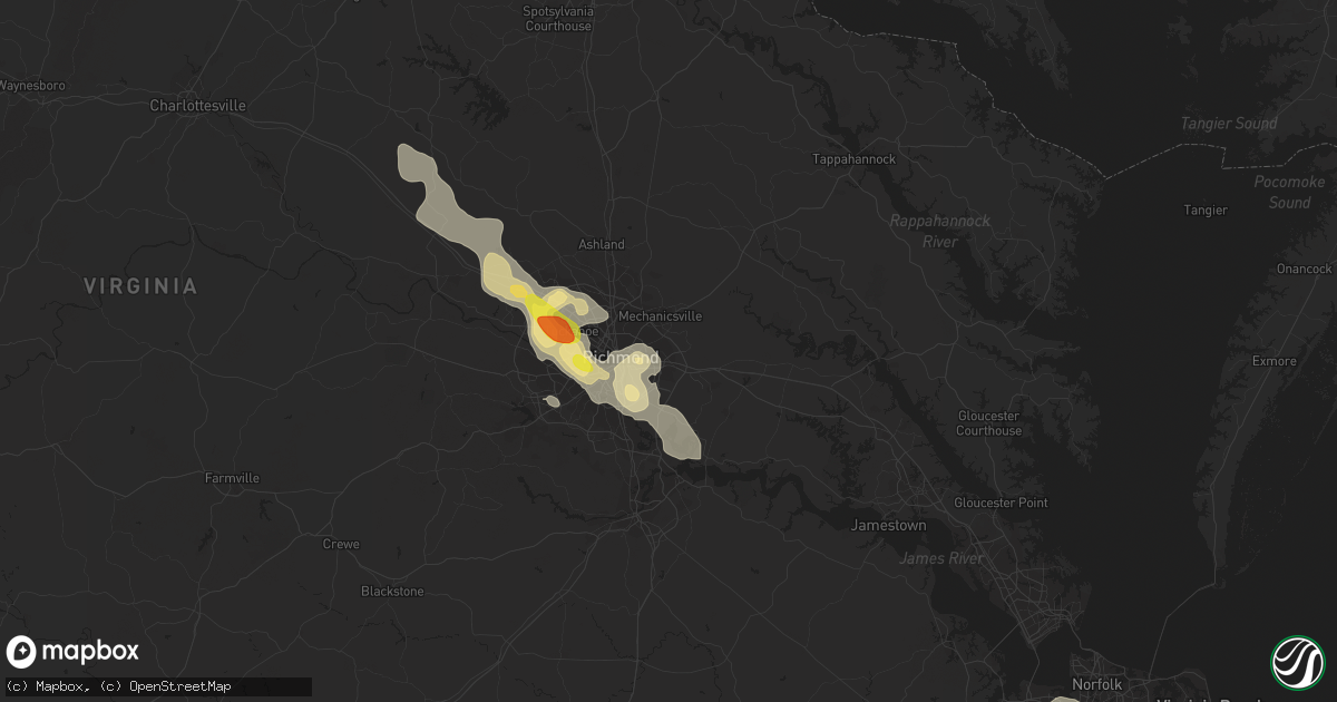
Hail Map in Henrico, VA on July 19, 2016
Get this storm
July 19 map
$229
one time, instant access
Download today. No call, no setup
Keep the $229
Bought the map and want the full workflow? Apply the entire $229 to a subscription within 7 days. None of it is wasted.
Every map, not just this one
This buys you this map. Subscription and you get every map we run, in the markets you choose from a few cities to whole states to nationwide. Plus real-time alerts the moment a storm fires.
Contact data
Name, contact info, occupancy, even credit band for addresses in the footprint. You go from where it hit to who to call.
Become the source they trust
Unlimited branding weather history reports on demand. You already have the documented answer ready for the property owner, and you are the one who showed up with it.
Property data and RoofTrace estimates
Pull up any address you have got, its value and the exact code rules for that jurisdiction, straight from One Click Code. Then RoofTrace estimates the squares, pitch, and roof value, priced the way you price.
Storm reports in Henrico, VA
Henrico, VA
| Date | Description |
|---|---|
| 07/19/20164:30 PM CDT | Several large limbs down. |
| 07/19/20164:25 PM CDT | Large tree across strath rd. Near kinvan. |
| 07/19/20164:25 PM CDT | Tree down near darbytown rd. |
| 07/19/20164:24 PM CDT | Tree blocking new market rd. Large limbs down. |
| 07/19/20164:20 PM CDT | Tree across southbury ave. |
| 07/19/20164:05 PM CDT | Trees down at britton rd and darbytown rd. |
| 07/19/20164:00 PM CDT | Tree down across labernum ave. Large tree limbs and branches down. |
| 07/19/20164:00 PM CDT | Large limbs down. |
| 07/19/20163:30 PM CDT | . |
| 07/19/20163:30 PM CDT | . |
| 07/19/20163:30 PM CDT | Quarter size hail at patterson and lauderdale. |
All States Impacted by Hail Map on July 19, 2016
All Cities Impacted by Hail Map on July 19, 2016
- Jonesborough, TN
- Pinehurst, GA
- Vienna, GA
- Sutherlin, VA
- Ringgold, VA
- Vienna, MD
- Stuarts Draft, VA
- Lyndhurst, VA
- Sterling, CO
- Fleming, CO
- Hawkinsville, GA
- Perry, GA
- Frostproof, FL
- Belhaven, NC
- Scranton, NC
- Moyock, NC
- De Soto, GA
- Leesburg, GA
- Musselshell, MT
- Stapleton, GA
- Blythe, GA
- Wrens, GA
- Matthews, GA
- Dearing, GA
- Augusta, GA
- Centreville, MD
- Goodridge, MN
- Saint Thomas, ND
- Hensel, ND
- Grafton, ND
- Crystal, ND
- Hoople, ND
- Disputanta, VA
- Sac City, IA
- Lytton, IA
- Fall Branch, TN
- Ocheyedan, IA
- Big Sandy, MT
- Zebulon, NC
- Knightdale, NC
- Oxford, NC
- Kittrell, NC
- Wendell, NC
- Wake Forest, NC
- Raleigh, NC
- Youngsville, NC
- Franklinton, NC
- Rolesville, NC
- Henderson, NC
- Lakefield, MN
- Clarks Hill, SC
- Fort Dodge, IA
- Mauk, GA
- Box Springs, GA
- Ivanhoe, NC
- Chinook, MT
- Queenstown, MD
- Allison, IA
- Bishopville, SC
- Willacoochee, GA
- Walhalla, ND
- Atlanta, GA
- Fairburn, GA
- Chevy Chase, MD
- Washington, DC
- Bethesda, MD
- Melville, MT
- Sumter, SC
- Dalzell, SC
- Union, OR
- Roundup, MT
- Portsmouth, IA
- Kershaw, SC
- Bethune, SC
- Cunningham, TN
- Telford, TN
- Bemidji, MN
- Eufaula, AL
- Duffield, VA
- Midland, NC
- Harrisburg, NC
- Concord, NC
- Charlotte, NC
- Stanley, ND
- Minto, ND
- Alvarado, MN
- Warren, MN
- Oslo, MN
- East Grand Forks, MN
- Bowie, MD
- Laurel, MD
- Beltsville, MD
- Adel, GA
- Estherville, IA
- Norway, SC
- Neeses, SC
- Springfield, SC
- Pine Lake, GA
- Decatur, GA
- Lithonia, GA
- Stone Mountain, GA
- Roper, NC
- Shevlin, MN
- Rochelle, VA
- Pratts, VA
- Madison, VA
- Aroda, VA
- Greentop, MO
- Queen City, MO
- Wataga, IL
- New Athens, IL
- Rhoadesville, VA
- Locust Grove, VA
- Spotsylvania, VA
- Supply, NC
- Richmond, VA
- Henrico, VA
- Boulder, CO
- Puposky, MN
- Westside, IA
- Vail, IA
- Jennings, FL
- Woodlawn, TN
- Franklin, VA
- Hyattsville, MD
- Brentwood, MD
- Riverdale, MD
- Fort Benning, GA
- Oglethorpe, GA
- Andersonville, GA
- Ideal, GA
- Russellville, TN
- Morristown, TN
- Maple Hill, NC
- Cove City, NC
- Swanquarter, NC
- Florence, SC
- Effingham, SC
- Edinburg, ND
- Walnut Cove, NC
- Sheffield, IA
- Hampton, IA
- Annapolis, MD
- Edgewater, MD
- Stevensville, MD
- Abingdon, IL
- Cando, ND
- Leeds, ND
- Gallatin, MO
- Hogansville, GA
- Pollocksville, NC
- Maysville, NC
- Fort Stewart, GA
- Hartsville, SC
- Society Hill, SC
- Patrick, SC
- Fort Bragg, NC
- Southern Pines, NC
- Jameson, MO
- Jamesport, MO
- Ruffin, SC
- Walterboro, SC
- Gainesboro, TN
- Roopville, GA
- Red Springs, NC
- Lumber Bridge, NC
- Shannon, NC
- Madison, FL
- Pearson, GA
- Axson, GA
- Shawmut, MT
- Kingston, MO
- Hamilton, MO
- Dover, NC
- Grifton, NC
- Ayden, NC
- Lancaster, MO
- Glenwood, MO
- Portsmouth, VA
- Bolivia, NC
- Bolton, NC
- Southport, NC
- Wilmington, NC
- Oak Island, NC
- Winnabow, NC
- Leland, NC
- Ash, NC
- Hopewell, VA
- Geyser, MT
- Prole, IA
- Saint Charles, IA
- Saint Pauls, NC
- Kinston, NC
- Tarboro, NC
- Lucas, IA
- Valdosta, GA
- Gonvick, MN
- Culpeper, VA
- Mitchells, VA
- Boston, VA
- Broadview, MT
- Rehoboth Beach, DE
- Oxon Hill, MD
- Fort Myer, VA
- Glen Echo, MD
- Arlington, VA
- Clinton, MD
- Naval Anacost Annex, DC
- Suitland, MD
- Temple Hills, MD
- Andrews Air Force Base, MD
- Cabin John, MD
- Van Meter, IA
- Brightwood, VA
- Etlan, VA
- Banco, VA
- Haywood, VA
- Reva, VA
- Syria, VA
- Lumberton, NC
- Senoia, GA
- Long Creek, OR
- Monument, OR
- Sciota, IL
- Blandinsville, IL
- Macomb, IL
- Shellman, GA
- Center, MO
- Woodbury, TN
- Readyville, TN
- Barnesville, GA
- Milner, GA
- East Saint Louis, IL
- Belleville, IL
- Buchanan, GA
- Maxton, NC
- Pembroke, NC
- Chambersburg, IL
- Griggsville, IL
- Elkton, VA
- Stanley, VA
- Celina, TN
- Whitleyville, TN
- Hilham, TN
- Norfolk, VA
- Ewing, MO
- Melrose, IA
- Russell, IA
- Chariton, IA
- Lovilia, IA
- Pineland, SC
- Delta, AL
- Lineville, AL
- Brayton, IA
- Exira, IA
- Varnville, SC
- Indianola, IA
- Lacona, IA
- Milo, IA
- Liberty Center, IA
- Montrose, GA
- Cochran, GA
- Chester, GA
- Danville, GA
- Windsor, NC
- Merry Hill, NC
- Westphalia, IA
- Harlan, IA
- Kirkman, IA
- Earling, IA
- Lewes, DE
- Millsboro, DE
- Bethany Beach, DE
- Wallowa, OR
- Petersburg, VA
- Chesterfield, VA
- Williamson, IA
- Chauncey, GA
- Nemaha, IA
- Newell, IA
- Fonda, IA
- Suffolk, VA
- Kingsport, TN
- Kenly, NC
- Lucama, NC
- Stites, ID
- Elko, GA
- Browning, IL
- Astoria, IL
- Braymer, MO
- Clear Lake, IA
- Thornton, IA
- Leonard, MN
- Redlake, MN
- Louisville, GA
- Waverly, VA
- Spring Grove, VA
- Falls Church, VA
- Rockwell City, IA
- Lake City, IA
- Spencer, IA
- Dickens, IA
- West Blocton, AL
- Langdon, ND
- Schaller, IA
- Galva, IA
- Cumming, IA
- Norwalk, IA
- Old Fort, NC
- Black Mountain, NC
- Abbeville, AL
- Gilmore City, IA
- Palmer, IA
- Pocahontas, IA
- Somers, IA
- Midlothian, VA
- Peshastin, WA
- Unionville, VA
- Mohawk, TN
- Bybee, TN
- Jackson, MN
- Rocky Mount, NC
- Imnaha, OR
- Headland, AL
- Newville, AL
- Washington, NC
- Moreland, GA
- Luthersville, GA
- Grantville, GA
- Greenville, GA
- Newnan, GA
- Gay, GA
- Salisbury, MD
- Dixie, GA
- Quitman, GA
- Pamplico, SC
- Pembroke, GA
- Weldon, IA
- Carlyle, IL
- Sandoval, IL
- Powhatan, VA
- Minnewaukan, ND
- Churchs Ferry, ND
- Devils Lake, ND
- Penn, ND
- Glasgow, VA
- Buena Vista, VA
- Natural Bridge, VA
- Monroe, VA
- Big Island, VA
- Bedford, VA
- Natural Bridge Station, VA
- Morganton, NC
- Otis, CO
- Akron, CO
- Harrington, DE
- Felton, DE
- Red Lake Falls, MN
- Manakin Sabot, VA
- Rockville, VA
- Chesapeake, VA
- Enterprise, OR
- Booneville, AR
- Winkelman, AZ
- Lagrange, GA
- Grand Forks, ND
- Battle Creek, IA
- Holstein, IA
- Coatsville, MO
- Bloomfield, IA
- Moulton, IA
- Bullock, NC
- Clayton, NC
- Claxton, GA
- Manvel, ND
- Blackduck, MN
- Swansboro, NC
- South Boston, VA
- Alton, VA
- Keeling, VA
- Glen Allen, VA
- Georgetown, DE
- Alexandria, VA
- Fort Washington, MD
- Santa Fe, MO
- Paris, MO
- Thompson, MO
- Woodland, GA
- Talbotton, GA
- Stanford, MT
- Blackville, SC
- Mineral, VA
- Chestertown, MD
- Ida Grove, IA
- Wilsons, VA
- Cottonwood, ID
- Catherine, AL
- Lake Wales, FL
- Partlow, VA
- Ruther Glen, VA
- Wakefield, VA
- Ivor, VA
- Marion, SC
- Englewood, CO
- Lake View, IA
- Bath, IL
- Tenstrike, MN
- Vanceboro, NC
- Hookerton, NC
- Trenton, NC
- Brevard, NC
- Rosman, NC
- Sunset, SC
- Greenfield, TN
- Hampton, GA
- Griffin, GA
- Pearisburg, VA
- Leary, GA
- Godfrey, IL
- Dow, IL
- Buckhead, GA
- Milton, NC
- Chatham, VA
- Vernon Hill, VA
- Yanceyville, NC
- Leasburg, NC
- Java, VA
- Semora, NC
- Blanch, NC
- Massena, IA
- Coffee Creek, MT
- Geraldine, MT
- Ruthven, IA
- Lugoff, SC
- Cadwell, GA
- Sperryville, VA
- Myrtle Beach, SC
- Novelty, MO
- Rock Hall, MD
- Gunpowder, MD
- Butler, AL
- Clearbrook, MN
- Crozet, VA
- Mount Ulla, NC
- Cleveland, NC
- Lamar, SC
- Deer Lodge, TN
- Hobgood, NC
- Battleboro, NC
- Whitakers, NC
- Winnett, MT
- Oilville, VA
- Greenville, IL
- Thomasville, AL
- Knoxville, IA
- Crozier, VA
- Versailles, IL
- Mount Sterling, IL
- Odum, GA
- Garland, NC
- Elizabethtown, NC
- Raeford, NC
- Woodburn, IA
- Thomaston, GA
- Hahira, GA
- Latimer, IA
- Coulter, IA
- Longs, SC
- Kevil, KY
- La Center, KY
- Prince George, VA
- Nashville, GA
- Waynesboro, VA
- Crimora, VA
- Sharpsburg, GA
- Perry, FL
- Roseville, IL
- Good Hope, IL
- Pennington, MN
- Dumont, IA
- Lostine, OR
- Black Hawk, CO
- Molt, MT
- Whiteville, NC
- Shelbyville, MO
- Garysburg, NC
- Bowdon, GA
- Franklin, GA
- Brodnax, VA
- La Crosse, VA
- South Hill, VA
- Monroe City, MO
- Naylor, GA
- Watertown, TN
- Alexandria, TN
- Maidens, VA
- Bumpass, VA
- Montpelier, VA
- Pine, CO
- Bailey, CO
- Conifer, CO
- Milford, IA
- Dawson, GA
- Rembert, SC
- Polk City, FL
- Lakeland, FL
- Laurel, DE
- Seaford, DE
- Rhodesdale, MD
- Bethel, DE
- Bogard, MO
- Potomac, MD
- Gaithersburg, MD
- Pell City, AL
- Washington, GA
- Fisher, MN
- Drayton, ND
- Cavalier, ND
- Grovetown, GA
- Hebron, MD
- Eolia, MO
- Thompson Falls, MT
- Surry, VA
- Bluffs, IL
- Butler, GA
- Fort Campbell, KY
- West Green, GA
- Herndon, KY
- Hopkinsville, KY
- Oak Grove, KY
- White Bird, ID
- Grangeville, ID
- Waterloo, IL
- Red Bud, IL
- Hecker, IL
- Windsor, VA
- Smithfield, VA
- Ridgeville, SC
- Sedley, VA
- Sanford, NC
- Hines, MN
- Grottoes, VA
- Americus, GA
- Graettinger, IA
- Jolley, IA
- Emporia, VA
- New London, MO
- Osceola, IA
- Saint Marys, IA
- Martensdale, IA
- New Virginia, IA
- Edina, MO
- Erwin, TN
- Louisa, VA
- Smithville, GA
- Leslie, GA
- Rapidan, VA
- Morgan, GA
- Belknap, IL
- Cypress, IL
- Cumberland Furnace, TN
- Islandton, SC
- House Springs, MO
- Wedowee, AL
- Pleasant Hill, NC
- Weldon, NC
- Gaston, NC
- Halifax, NC
- Havelock, NC
- Gate City, VA
- Leon, VA
- Oracle, AZ
- Bronwood, GA
- Stella, NC
- Lawrenceville, VA
- Warner Robins, GA
- New Bern, NC
- Brandywine, MD
- Huntingtown, MD
- Owings, MD
- Aquasco, MD
- Upper Marlboro, MD
- Alpha, MN
- West Point, VA
- Clayton, AL
- Fayetteville, NC
- Exline, IA
- Unionville, MO
- Pikeville, NC
- Fremont, NC
- Carrollton, MO
- Sims, NC
- Wilson, NC
- Creston, IA
- Climax, MN
- Waverly Hall, GA
- Greensboro, GA
- Udell, IA
- Centerville, IA
- Winchester, IL
- Cumberland, VA
- Farmville, VA
- Dillwyn, VA
- Reynolds, GA
- Milford, DE
- Nesmith, SC
- Woodbury, GA
- Renwick, IA
- Luray, VA
- Mount Vernon, GA
- Kilbourne, IL
- Easton, IL
- Vienna, IL
- Karnak, IL
- Ullin, IL
- Dongola, IL
- Galesburg, IL
- Bealeton, VA
- Warrenton, VA
- Jeffersonton, VA
- Remington, VA
- Rixeyville, VA
- Kila, MT
- Parkton, NC
- Gibson, GA
- Warrenton, GA
- Derby, IA
- Woodford, VA
- Meservey, IA
- Goodell, IA
- Tignall, GA
- Summerville, SC
- Ravenel, SC
- Pilot Rock, OR
- Soperton, GA
- Cuthbert, GA
- Knox City, MO
- Briceville, TN
- Georgetown, GA
- Gum Spring, VA
- McLean, VA
- Rockville, MD
- Cheltenham, MD
- Newington, GA
- Equality, AL
- Reynolds, ND
- Thompson, ND
- Patoka, IL
- Louisville, AL
- Macon, NC
- Ebony, VA
- Littleton, NC
- Bracey, VA
- Chester, MD
- Breda, IA
- Farnhamville, IA
- Gowrie, IA
- Paton, IA
- Churdan, IA
- Cullman, AL
- Vinemont, AL
- Barnardsville, NC
- Albany, GA
- Vass, NC
- Corwith, IA
- Philadelphia, MO
- Durham, MO
- Pleasantville, IA
- Barney, GA
- Tarrytown, GA
- Livonia, MO
- Cragford, AL
- Davidsonville, MD
- Harwood, MD
- Ackworth, IA
- Clarksville, TN
- Bethel, MO
- La Belle, MO
- Memphis, TN
- Prince Frederick, MD
- Marion, AR
- Pearce, AZ
- Columbia, TN
- Rentz, GA
- Dublin, GA
- Walnut, IA
- Garnett, SC
- Clyo, GA
- Tillman, SC
- Ridge Spring, SC
- Ward, SC
- Newport, NC
- Deloit, IA
- Ray City, GA
- Cameron, NC
- Coward, SC
- Scranton, SC
- Greenville, IA
- Royal, IA
- Jefferson, IA
- Ladson, SC
- Adrian, GA
- Swainsboro, GA
- Lakeland, GA
- Harcourt, IA
- Harbeson, DE
- Frankford, DE
- Ocean View, DE
- Fitzgerald, GA
- Kingston, GA
- Rome, GA
- Monticello, GA
- Mexico, MO
- Rutledge, MO
- Bradford, TN
- Cass Lake, MN
- Salley, SC
- Humeston, IA
- Garden Grove, IA
- Gracey, KY
- Unadilla, GA
- Ludlow, MO
- Norborne, MO
- Lignum, VA
- Beaverdam, VA
- Burr Hill, VA
- Jacksonville, NC
- Camden, SC
- Spirit Lake, IA
- Hurlock, MD
- Federalsburg, MD
- Bonaire, GA
- Kathleen, GA
- Bon Aqua, TN
- Lyles, TN
- Cincinnati, IA
- Fairfield, NC
- Melcher Dallas, IA
- Lula, GA
- Fenton, IA
- Lone Rock, IA
- Silver Spring, MD
- El Paso, TX
- Grand Junction, IA
- Dana, IA
- Chadbourn, NC
- Evergreen, NC
- Shelbina, MO
- Stony Creek, VA
- Carrsville, VA
- Courtland, VA
- Zuni, VA
- Carson, VA
- Perry, MO
- Cordele, GA
- Tallassee, AL
- Tuskegee, AL
- Shorter, AL
- Snow Hill, NC
- Jakin, GA
- Murray, KY
- Union Grove, AL
- Albert City, IA
- Pinetta, FL
- Eastman, GA
- Sioux Rapids, IA
- Bowling Green, MO
- Hope Mills, NC
- Clarksville, VA
- Alapaha, GA
- Ambrose, GA
- Douglas, GA
- Pine Mountain, GA
- Sutherland, IA
- Peterson, IA
- Denver, CO
- Littleton, CO
- Big Timber, MT
- Columbus, MT
- Toano, VA
- Orondo, WA
- Lomax, IL
- Raritan, IL
- Atlantic, IA
- Tiplersville, MS
- Sandston, VA
- Chester, VA
- Charles City, VA
- Ludowici, GA
- Glennville, GA
- Hartley, IA
- Osnabrock, ND
- Baylis, IL
- La Grande, OR
- Willard, NC
- Cassatt, SC
- Forest City, IA
- Norcross, GA
- Lilburn, GA
- Columbia, SC
- Anita, IA
- Fowler, IL
- Paloma, IL
- Quincy, IL
- Lohrville, IA
- Altoona, AL
- Boaz, AL
- Batesburg, SC
- Cascilla, MS
- Morris, GA
- Palmyra, MO
- Rayle, GA
- Virginia Beach, VA
- Rolfe, IA
- Zebulon, GA
- Richlands, NC
- Charlotte, TN
- Dickson, TN
- Lewistown, IL
- Register, GA
- Macedonia, IL
- Thompsonville, IL
- Bancroft, IA
- Swea City, IA
- Goldfield, IA
- Greeneville, TN
- Concord, IL
- Chapin, IL
- Milan, GA
- Pisgah Forest, NC
- Stoutsville, MO
- Jacksonville, IL
- Monroe, NC
- Lexington, VA
- Rutland, IA
- Bode, IA
- Humboldt, IA
- Buena Vista, GA
- Euclid, MN
- Argyle, MN
- Mountain, ND
- Spickard, MO
- Beaufort, NC
- Trenton, TN
- Red Oak, VA
- Nashville, NC
- Guyton, GA
- Brooklet, GA
- Central City, CO
- Bath, NC
- Hunnewell, MO
- Portage Des Sioux, MO
- Lothian, MD
- Dagsboro, DE
- Millville, DE
- Milton, DE
- Oskaloosa, IA
- Nashville, TN
- Church Road, VA
- Ford, VA
- Manchester, GA
- Grimesland, NC
- Chocowinity, NC
- Livermore, IA
- York, ND
- Gordonsville, VA
- Manson, IA
- Ernul, NC
- Garner, IA
- Clare, IA
- Barnum, IA
- Persia, IA
- Lebanon, TN
- Mansfield, WA
- Camp Lejeune, NC
- Lamont, FL
- Vermont, IL
- Ipava, IL
- Ellaville, GA
- Brandy Station, VA
- Wray, GA
- Colchester, IL
- Golden, CO
- Tallapoosa, GA
- Hubert, NC
- Wallace, NC
- Mount Rainier, MD
- Takoma Park, MD
- Capitol Heights, MD
- Kensington, MD
- District Heights, MD
- College Park, MD
- Bladensburg, MD
- Dunkirk, MD
- Neola, IA
- Roberta, GA
- Salem, FL
- Steinhatchee, FL
- Lavina, MT
- Mitchell, GA
- Sealevel, NC
- Crawfordville, FL
- Skippers, VA
- Elk Horn, IA
- Saint Regis, MT
- Ryegate, MT
- Grantsboro, NC
- Union Springs, AL
- Eatonton, GA
- Amelia Court House, VA
- Sparta, IL
- Castleton, VA
- Shelby, IA
- Panama, IA
- Audubon, IA
- Kimballton, IA
- Avoca, IA
- Rembrandt, IA
- Roseboro, NC
- Clinton, NC
- West End, NC
- Windsor, SC
- Williston, SC
- Alexander, IA
- Shorterville, AL
- Loris, SC
- Charleston, AR
- Pomeroy, IA
- Glidden, IA
- Roanoke Rapids, NC
- Kidder, MO
- Odin, IL
- Holiday, FL
- New Port Richey, FL
- Geneva, IA
- Wingate, NC
- Broxton, GA
- Shenandoah, VA
- Macon, GA
- Bladenboro, NC
- Downing, MO
- Britt, IA
- Correctionville, IA
- Cushing, IA
- Oneonta, AL
- Taylor, MO
- Bussey, IA
- Ashville, AL
- Steele, AL
- Ashland, AL
- Greenwood, VA
- Afton, VA
- Charlottesville, VA
- Oberon, ND
- Prairie City, OR
- Whitesburg, TN


