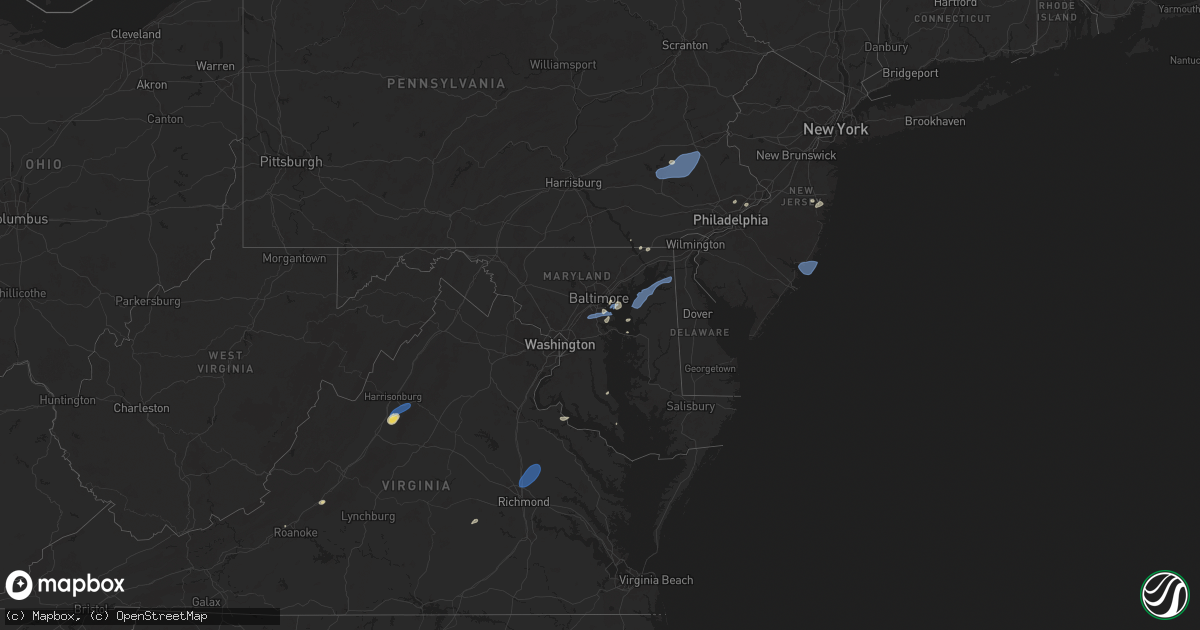
Hail Map on July 1, 2025
Get this storm
July 1 map
$229
one time, instant access
Download today. No call, no setup
Keep the $229
Bought the map and want the full workflow? Apply the entire $229 to a subscription within 7 days. None of it is wasted.
Every map, not just this one
This buys you this map. Subscription and you get every map we run, in the markets you choose from a few cities to whole states to nationwide. Plus real-time alerts the moment a storm fires.
Contact data
Name, contact info, occupancy, even credit band for addresses in the footprint. You go from where it hit to who to call.
Become the source they trust
Unlimited branding weather history reports on demand. You already have the documented answer ready for the property owner, and you are the one who showed up with it.
Property data and RoofTrace estimates
Pull up any address you have got, its value and the exact code rules for that jurisdiction, straight from One Click Code. Then RoofTrace estimates the squares, pitch, and roof value, priced the way you price.
States Impacted by Hail Map on July 1, 2025
Storm reports
Nebraska
| Date | Description |
|---|---|
| 07/01/20252:35 AM CDT | Awos station konl o''neill airport. |
| 06/30/20258:29 PM CDT | Report via social media. |
New York
| Date | Description |
|---|---|
| 07/01/20253:52 PM CDT | Tree downed and across roadway at intersection of bethel cross road and strever farm road. |
| 07/01/20253:35 PM CDT | Tree downed with branches blocking albany post road at market street. |
| 07/01/20253:15 PM CDT | Tree downed at intersection of state route 199 and wilcox park road. |
| 07/01/20253:00 PM CDT | Trees downed on route 50 near the corner of gleason road. |
| 07/01/20252:51 PM CDT | Tree down on wires near the intersection of pratt hill rd and acorn ln. Time estimated from radar. |
| 07/01/20252:38 PM CDT | Tree downed on a house on knollwood avenue. |
| 07/01/20252:12 PM CDT | Tree downed and blocking stone arabia road in the town of mohawk. |
| 07/01/20252:11 PM CDT | Tree downed on phillips avenue. |
| 07/01/20252:10 PM CDT | Tree down southwest of johnstown along ny 334. |
Montana
| Date | Description |
|---|---|
| 07/01/20256:56 PM CDT | Asos station kbzn bozeman yellowstone airport. |
| 07/01/20256:49 PM CDT | Asos station kbzn bozeman yellowstone airport. |
| 07/01/20256:45 PM CDT | Corrects previous tstm wnd dmg report from 2 nw bozeman. Trained spotter reports 4 inch diameter tree limb broken with leaves and debris on roadway in the vicinity of e |
| 07/01/20256:33 PM CDT | Asos station kbzn bozeman yellowstone airport. |
| 06/30/20257:46 PM CDT | Asos station klvm livingston. |
| 06/30/20257:21 PM CDT | Corrects previous tstm wnd gst report from 7 ene livingston. Asos station klvm livingston. |
| 06/30/20257:00 PM CDT | Mesonet station mtbzh bozeman pass |
Colorado
| Date | Description |
|---|---|
| 06/30/20258:11 PM CDT | A local report indicates 58 MPH wind near 1 NNW Akron |
North Carolina
| Date | Description |
|---|---|
| 07/01/20255:30 PM CDT | Tree down near the intersection of wards gap road and crossingham road. |
| 07/01/20255:10 PM CDT | Tree down near the intersection of west dodson road and whitaker chapel road. |
| 07/01/20254:42 PM CDT | Tree down at intersection of cook school road and cook school road ext. Time estimated from radar. |
| 07/01/20254:21 PM CDT | Several trees and utility lines blown down around the town of wilkesboro. Time estimated from radar. |
| 07/01/20254:21 PM CDT | Several trees and utility lines blown down around the town of |
| 06/30/20257:57 PM CDT | Trees on power lines at alamance church rd and andrews dairy rd... Resulting in power outages. |
| 06/30/20257:57 PM CDT | Trees on power lines at alamance church rd and andrews dairy rd... Result |
| 06/30/20257:06 PM CDT | Tree down on power lines at shell rd and pilot school rd... Resulting in power outages. |
| 06/30/20257:00 PM CDT | 911 communications reported a tree blocking roadway on lavender road. |
Kentucky
| Date | Description |
|---|---|
| 07/01/20253:18 PM CDT | Kenwood drive briefly flooded with debris. |
| 07/01/20251:31 PM CDT | Power pole with guy wire broken. Time estimated from radar. |
Virginia
| Date | Description |
|---|---|
| 07/01/20256:54 PM CDT | Tree down partially blocking blairmont drive near finch drive. Time estimated from radar. |
| 07/01/20256:50 PM CDT | Numerous trees down in the proximity of hague. |
| 07/01/20256:49 PM CDT | Thunderstorm winds blew down one tree along the 4400 block of henrys mill road. |
| 07/01/20256:47 PM CDT | Corrects previous tstm wnd dmg report from 2 wnw brosville. Tree down. |
| 07/01/20256:45 PM CDT | Tree down. |
| 07/01/20256:43 PM CDT | Numerous trees down in mt. Holly. |
| 07/01/20256:40 PM CDT | The 911 call center reported a tree down on cartersville road. Time estimated from radar. |
| 07/01/20256:28 PM CDT | Tree downed and blocking us-17 in the vicinity of occupacia rd. |
| 07/01/20256:26 PM CDT | A couple of trees knocked down in westmoreland state park. |
| 07/01/20256:08 PM CDT | A tree knocked down a powerline on buckner rd. |
| 07/01/20256:04 PM CDT | Trees and large branches blew down on va-629 round hill road blocking the roadway west of jean drive. |
| 07/01/20256:03 PM CDT | Tree down along crocketts cove road. |
| 07/01/20256:00 PM CDT | 2 trees down near sunshine rd along rt. 301. |
| 07/01/20255:56 PM CDT | A tree fell down in bowling green. |
| 07/01/20255:55 PM CDT | 2 trees down along rt-301. |
| 07/01/20255:50 PM CDT | Tree down at the intersection of herring and west river rd. |
| 07/01/20255:50 PM CDT | Tree knocked down at the intersection of hazelwood and w river rd. |
| 07/01/20255:48 PM CDT | A large tree fell onto a house on white oak drive. No injuries reported. |
| 07/01/20255:43 PM CDT | A power line was blown down by thunderstorm winds near the intersection of cross stitch road and mount cross road. Time estimated from radar. |
| 07/01/20255:36 PM CDT | A tree fell down at the intersection of pleasant mill rd and mabelton rd. |
| 07/01/20255:33 PM CDT | A tree fell at the intersection of east patrick henry rd and woodside ln. |
| 07/01/20255:30 PM CDT | A tree fell down along cady mills rd. |
| 07/01/20255:25 PM CDT | Tree down in the state forest across woolridge road near state park road. |
| 07/01/20255:23 PM CDT | A tree fell down along greenwood rd. |
| 07/01/20255:22 PM CDT | Thunderstorm winds blew down one tree along the 5100 block of burkes garden road close to the intersection with gose mill road. |
| 07/01/20255:21 PM CDT | The public reported several trees down across the city of richmond. Time estimated from radar. |
| 07/01/20255:21 PM CDT | The public reported several trees down acr |
| 07/01/20255:20 PM CDT | The ashland... Hanover county municipal airport asos |
| 07/01/20255:20 PM CDT | The |
| 07/01/20255:15 PM CDT | Corrects previous tstm wnd dmg report from 3 s appomattox. Tree down on red house road. |
| 07/01/20255:01 PM CDT | Several trees down around the raven and richlands areas. Time estimated from radar. |
| 07/01/20255:01 PM CDT | Thunderstorm winds blew down one tree along wardell road near the intersections with route 19 and whisper lane. |
| 07/01/20254:57 PM CDT | Thunderstorm winds blew down one tree on laurel road. |
| 07/01/20254:50 PM CDT | Storm damaged caused a power outage near gordonsville. |
| 07/01/20254:20 PM CDT | Tree down near intersection of rt 15 and petersburg rd |
| 07/01/20254:15 PM CDT | Several trees blew down around a cooperative weather observer's residence in somerset |
| 07/01/20254:13 PM CDT | Large tree down near intersection of rt 20 and jacksontown rd |
| 07/01/20254:09 PM CDT | Tree down near intersection of rt 20 and spotswood trail |
| 07/01/20254:06 PM CDT | Three calls for trees down near wolftown. |
| 07/01/20253:57 PM CDT | Two trees reported down in graves mill area. |
| 07/01/20253:48 PM CDT | Tree down along sandlick road near haysi. Time estimated from radar. |
| 07/01/20253:43 PM CDT | Two trees reported down on skyline drive near brown mountain. |
| 07/01/20253:39 PM CDT | Tree down at dante mountain rd. And stratton bridge rd. In nora. Time estimated from radar. |
| 07/01/20253:30 PM CDT | Several large trees blew down around grottoes. |
| 07/01/20253:29 PM CDT | There were several reports of wind damage around mount crawford... Including wires down in the 6600 block of scholars road. |
| 07/01/20252:18 PM CDT | Thunderstorm winds blew down one tree near the intersection of eastern avenue and osborne street. |
| 07/01/20252:17 PM CDT | There were a few calls for large tree limbs blown down across southern arlington. |
| 07/01/20252:12 PM CDT | Trees and large branches blew down on elmwood drive near south quaker lane. |
| 07/01/20252:02 PM CDT | Thunderstorm winds blew down several large limbs near the intersection of westside boulevard and panorama avenue. |
| 07/01/20252:00 PM CDT | Thunderstorm winds blew down several large limbs near the intersection of westside boulevard and panorama avenue. |
| 07/01/20251:55 PM CDT | Tree damage was reported near fairfax... Including a tree that blew down on va-699 prosperity avenue near morningside drive. |
| 07/01/20251:50 PM CDT | There were a couple of calls for trees and wires blown down in southern fairfax county. |
| 07/01/20251:46 PM CDT | Tree down onto powerlines near intersection of rocks gap r |
| 07/01/20251:46 PM CDT | Tree down onto powerlines near intersection of rocks gap rd and runions creek rd |
| 07/01/20251:44 PM CDT | Wind damage was reported near chantilly... Including a power pole down near fair lakes parkway. |
| 07/01/20251:42 PM CDT | Trees and large branches blew down on fauquier lane near va-673 lawyers road. |
| 07/01/20251:39 PM CDT | Large tree limbs |
| 07/01/20251:26 PM CDT | There were a few calls for trees and wires blown down across the city of alexandria. |
| 07/01/202512:51 PM CDT | Two trees down just east of ryleyville on rileyville rd |
| 07/01/202512:47 PM CDT | Tree damage was reported southeast of alanthus... Including a tree that blew down near the intersection of va-663 alanthus road and farley road. |
| 06/30/20258:40 PM CDT | Tree down along on rt. 623. |
| 06/30/20258:40 PM CDT | Tree down along on rt. 62 |
| 06/30/20258:24 PM CDT | Power outages caused by storm damage. |
| 06/30/20258:16 PM CDT | A tree fell down on palmyra ave. |
| 06/30/20258:16 PM CDT | 2 |
| 06/30/20258:16 PM CDT | Multiple trees down on wellington street. |
| 06/30/20258:16 PM CDT | A tree fell down on fauquier ave. |
| 06/30/20258:16 PM CDT | 2 trees down along seminary dr. |
| 06/30/20258:15 PM CDT | Multiple trees down on north ave. |
| 06/30/20258:15 PM CDT | Tree fell down on w providence rd. |
| 06/30/20258:15 PM CDT | A tree fell down knocking down a powerline on seddon rd. |
| 06/30/20258:10 PM CDT | Tree fell down at the intersection of maple ave & linden ln. |
| 06/30/20258:05 PM CDT | ~ 8 thousand people with loss of power caused by thunderstorm damage. |
| 06/30/20258:03 PM CDT | Tree fell down at the intersection of new kent rd and prince author rd. |
| 06/30/20257:50 PM CDT | Powerlines damaged by severe weather causing power outages across powhatan county. |
| 06/30/20257:45 PM CDT | Storm damage caused power outage across pats of the town of farmville. |
| 06/30/20257:41 PM CDT | The 911 call center reported several trees down across the county. Time estimated from radar. |
| 06/30/20257:41 PM CDT | The 911 call center reported several trees down across the county. Some fallen trees resulted in power outages. Time estimated from radar. |
| 06/30/20257:32 PM CDT | Powerlines knocked down by severe weather causing power outages across amelia county. |
| 06/30/20257:32 PM CDT | Tree down on rt. 609 in the county of amelia... In the vicinity of elm cottage rd; rt. 629e/w |
| 06/30/20257:25 PM CDT | Updated report. Northbound va-605 closed at genito rd due to a downed tree. Time is radar-estimated. |
| 06/30/20257:07 PM CDT | Tree down along broad street rd. |
| 06/30/20257:02 PM CDT | The 911 call center reported a tree down on maple grove. Time estimated from radar. |
Connecticut
| Date | Description |
|---|---|
| 07/01/20256:06 PM CDT | In woodstock... A large tree limb was down on roseland park rd. Relayed by amateur radio. |
| 07/01/20255:49 PM CDT | In wethersfield a tree fell onto a home on brimfield road. Relayed via amateur radio. |
Wyoming
| Date | Description |
|---|---|
| 07/01/20254:16 PM CDT | Asos station kdgw douglas airport - dgw. |
| 07/01/20253:00 PM CDT | [landspout] landspout tornado was on the ground for 3 or 4 minutes before dissipating. |
Maryland
| Date | Description |
|---|---|
| 07/01/20256:51 PM CDT | Trees downed along johnson road in hollywood... Md as storms move through. |
| 07/01/20256:51 PM CDT | A couple calls for trees down on willows road near point lookout road. |
| 07/01/20256:49 PM CDT | Tree onto a residence on winding way. |
| 07/01/20256:47 PM CDT | Tree damage reported on medleys neck road between point lookout road and breton drive. |
| 07/01/20256:46 PM CDT | Multiple trees uprooted and damaged along breton bay drive. |
| 07/01/20256:45 PM CDT | Nws confirmed a tornado touched down two miles south of leonardtown... In beauvue... Maryland... In consultation with st. Mary's county emergency management. The tornad |
| 07/01/20255:15 PM CDT | Tree damage was reported near mechanicsville... Including a tree that blew down onto a house in the 40200 block of waterview drive. |
| 07/01/20255:05 PM CDT | Tree damage was reported near huntingtown... Including a tree that blew down in the 2400 block of kimberly lane. |
| 07/01/20255:05 PM CDT | Tree damage was reported in huntingtown... Including a tree that blew down onto power lines causing a fire in the 1600 block of stone drive. |
| 07/01/20254:21 PM CDT | Trees down around centreville. Time estimated from radar. |
| 07/01/20254:07 PM CDT | Trees down. Time estimated from radar. |
| 07/01/20253:51 PM CDT | Trees down around the rock hall area. Time estimated from radar. |
| 07/01/20253:40 PM CDT | Trees and large branches blew down on eastbound md-7 philadelphia road past md-152 mountain road. |
| 07/01/20253:34 PM CDT | Tree damage was reported in bel air... Including a tree that blew down onto an unoccupied car in the 100 block of duncannon road. |
| 07/01/20253:34 PM CDT | Tr |
| 07/01/20253:25 PM CDT | There were a few calls for trees and wires down in eastern baltimore county. |
| 07/01/20253:25 PM CDT | Trees and large branches blew down on us-50 near exit 29/md-179 cape saint claire road. |
| 07/01/20252:30 PM CDT | Tree damage was reported in riverdale... Including a tree that blew down onto power lines in the 6400 block of 46th avenue. |
| 07/01/20252:20 PM CDT | Tree damage was reported in oxon hill... Including a tree that blew down into the roadway blocking a driveway in the 900 block of east meadow court. |
| 07/01/20252:20 PM CDT | Tree fell onto a car near 13000th block of old frederick road in sykesville. |
| 07/01/20252:12 PM CDT | Trees and large branches blew down on md-80 fingerboard road at chaucer court/tranquility court. |
| 07/01/20252:08 PM CDT | Tree damage was reported in bethesda... Including a tree that brought down wires and damaged a pole in the 9900 block of de paul drive. |
| 07/01/20252:00 PM CDT | Trees and large branches blew down on southbound i-270 at exit 6/md-28 west montgomery avenue. |
| 07/01/20251:59 PM CDT | Trees and large branches blew down on southbound i-495 capital beltway outer loop at exit 39/md-190 river road. |
| 07/01/20251:59 PM CDT | Two trees down on red pump rd north of rising sun |
| 07/01/20251:55 PM CDT | Tree damage was reported near roxbury mills... Including a large tree that blew down onto flintridge drive near sundown road. |
| 07/01/20251:35 PM CDT | Tree damage was reported near brunswick... Including a tree that blew down on md-478 knoxville road at western avenue. |
| 06/30/20257:46 PM CDT | Multiple trees down at the intersection of elliot island and steele neck rd. |
| 06/30/20257:35 PM CDT | Numerous powerlines down across cambridge. |
Nevada
| Date | Description |
|---|---|
| 07/01/20256:03 PM CDT | Harry reid international airport. |
| 07/01/20256:00 PM CDT | This gust was associated with a virga shower. |
| 07/01/20256:00 PM CDT | Power poles and lines were blown down near las vegas blvd and robindale rd... Associated with a virga shower. Time of occurrence estimated by radar. |
| 07/01/20255:49 PM CDT | This gust was associated with a virga shower. |
| 07/01/20255:42 PM CDT | Power poles and trees were blown down near the intersection of flamingo and burnham... Associated with a virga shower. Time of occurrence estimated by radar. |
| 07/01/20255:40 PM CDT | Approximately 20 power poles were blown down near the intersection of tropicana and mcleod... Associated with a virga shower. Time of occurrence estimated by radar. |
| 07/01/20255:34 PM CDT | This gust was associated with a virga shower. Data courtesy of earthnetworks. |
| 07/01/20255:24 PM CDT | Inspirada area. Associated with showers and virga bombs. Report courtesy of earthnetworks. |
| 07/01/20255:24 PM CDT | Northeast las vegas. Associated with showers and virga bombs. Report courtesy of earthnetworks. |
| 07/01/20254:54 PM CDT | Local news media and public social media post reports power lines down at east sahara ave and south eastern ave. Wind damage associated with showers and virga bombs. |
| 07/01/20254:30 PM CDT | A large piece of debris... Possibly a portion of a roof... Was blown into the street. This event was associated with a virga shower. |
| 07/01/20254:23 PM CDT | Inspirada area. Associated with showers and virga bomb. Report courtesy of earthnetworks. |
| 07/01/20254:18 PM CDT | Whitney... Nv area. Associated with showers and virga bomb. Report courtesy of earth networks. |
| 07/01/20254:05 PM CDT | Associated with showers and virga bomb. North las vegas airport. |
| 07/01/20253:42 PM CDT | Henderson executive airport. Associated with showers and virga bomb. |
| 07/01/20253:38 PM CDT | This corrects a previous lsr which had an incorrect location for this event. Data courtesy of earthnetworks. |
| 07/01/20252:41 PM CDT | Station: rock spring creek... Id: rscn2... Elevation: 5427 feet. |
| 06/30/202510:30 PM CDT | This gust was associated with a virga shower. |
| 06/30/20258:35 PM CDT | Peak outflow gust at mesonet station tornv 9.8 ne trinity junction |
| 06/30/20258:35 PM CDT | Peak outflow gust at mesonet station tornv 9.8 ne trinity junction (nv |
| 06/30/20258:35 PM CDT | Peak outflow gust at mesonet station tornv 9.8 ne trinity junction . |
| 06/30/20258:00 PM CDT | Peak outflow gust at mesonet station nv025 carson city. |
| 06/30/20257:59 PM CDT | Peak outflow gust at mesonet station jctnv 1.0 w stewart |
| 06/30/20257:50 PM CDT | Peak outflow gust at mesonet station cw8738 reno. |
| 06/30/20257:30 PM CDT | Peak outflow gust at mesonet station rgx virginia peak. |
New Jersey
| Date | Description |
|---|---|
| 07/01/20256:05 PM CDT | Njwxnet station at little egg harbor. Sustained wind of 55 mph also reported. |
| 07/01/20253:40 PM CDT | Multiple trees down. Time estimated from radar. |
| 07/01/20253:30 PM CDT | Multiple trees down. Time estimated |
| 07/01/20253:30 PM CDT | Multiple trees down. Time estimated from radar. |
Idaho
| Date | Description |
|---|---|
| 07/01/20256:59 PM CDT | Idaho power reports outages in the moreland and riverside areas due to thunderstorm outflow winds. |
| 07/01/20256:14 PM CDT | About 26 customers without power in the inkom area. |
| 07/01/20255:17 PM CDT | Measured at the cotton ridge raws |
| 07/01/20255:17 PM CDT | Mea |
| 07/01/20255:17 PM CDT | Measured at the cotton ridge raws mesonet site. |
| 07/01/20254:49 PM CDT | Several hundred customers without power near and east of pingree. |
| 07/01/20254:46 PM CDT | About 120 customers without power in the are west of springfield. |
| 07/01/20254:45 PM CDT | Measured at the inl puzzle itd mesonet site. |
| 07/01/20253:21 PM CDT | Corrects previous tstm wnd gst report from 1 ssw michaud. |
Georgia
| Date | Description |
|---|---|
| 07/01/20255:30 PM CDT | Tree down near intersection of camp viola rd and mountville-hogansville rd. |
| 07/01/20255:20 PM CDT | Tree down near mm 22 in troup county along i-85. |
| 07/01/20255:08 PM CDT | Tree down at keys ferry and peoples rd. |
| 07/01/20255:07 PM CDT | Tree down at four points rd and jim mcmichael road. |
| 07/01/20255:00 PM CDT | Tree down along 2000 block of highway 54. |
Mississippi
| Date | Description |
|---|---|
| 07/01/20255:43 PM CDT | A utility line was downed off hwy 49 north of magee. |
| 07/01/20255:30 PM CDT | A large oak tree was downed on 15th street near 33rd avenue in gulfport. |
| 07/01/20255:25 PM CDT | A utility line was downed along ms hwy 27. |
| 07/01/20255:09 PM CDT | A few trees down in town... Oak st... Confederate ave. |
| 07/01/20255:00 PM CDT | A large tree fell across the roadway in the 1200 block of greenfield circle. |
| 07/01/20254:59 PM CDT | Public reported power lines down on washington avenue near bayou view. |
| 07/01/20254:59 PM CDT | Asos station kgpt gulfport-biloxi intl airport. |
| 07/01/20254:59 PM CDT | Public reported a tree down on west pine street. |
| 07/01/20254:56 PM CDT | Asos station kgpt gulfport-biloxi intl airport. |
| 07/01/20254:40 PM CDT | Lines down and power out. |
| 07/01/20254:40 PM CDT | A large pine tree was blown down onto a power line north of the intersection of robinson springs road and pocahontas road. |
| 07/01/20254:40 PM CDT | Large tree branch down near popps ferry road. |
| 07/01/20254:20 PM CDT | A utility wire was downed off rice rd. |
| 07/01/20254:15 PM CDT | A tree was blown down onto a power line at the intersection of n railroad street and green acres drive. |
| 07/01/20254:00 PM CDT | Several trees down ne of canton. |
| 07/01/20253:49 PM CDT | Lines down and a large area out of power n of canton. |
| 07/01/20253:34 PM CDT | Kpib measured 60 mph wind gust. |
South Carolina
| Date | Description |
|---|---|
| 07/01/20256:50 PM CDT | A few trees blown down near the intersection of concord road and pleasant school road. |
| 07/01/20256:04 PM CDT | Schp reports tree in roadway at woodruff rd and hwy 14. |
| 07/01/20255:38 PM CDT | Downed trees or limbs caused power outages on data bush dr. Time estimated from radar. |
| 07/01/20255:30 PM CDT | Fallen trees or limbs caused power outage on zet court. Time estimated from radar. |
| 07/01/20255:27 PM CDT | Power outage attributed to fallen trees or limbs at w parker rd and w marion st. Time estimated. |
Alabama
| Date | Description |
|---|---|
| 07/01/20254:50 PM CDT | Tree down on summerfield rd. |
| 07/01/20254:07 PM CDT | Trees down across the road in centreville. |
Massachusetts
| Date | Description |
|---|---|
| 07/01/20256:25 PM CDT | In mendon a tree was down blocking more than half of crestview drive. Relayed via amateur radio. |
| 07/01/20256:15 PM CDT | In northbridge a tree was downed in the area of purgatory road. Report relayed via amateur radio. |
| 07/01/20255:00 PM CDT | In belchertown... There was a large branch down on power lines blocking town beach rd. |
| 07/01/20255:00 PM CDT | In belchertown there were multiple powerlines down in the area of george hannum street. Report relayed via amateur radio. |
| 07/01/20255:00 PM CDT | In belchertown... Multiple wires were down on pelham road near federal street. Report relayed via amateur radio. |
| 07/01/20253:50 PM CDT | Spotter saw two downed trees on side of county and williamsburg roads near ashfield on his drive home. Time estimated from radar. |
| 07/01/20253:20 PM CDT | Report of a tree down on wires in the vicinity of sherwood drive in lenox. Time estimated from radar. |
| 07/01/20253:10 PM CDT | Several reports of trees on wires in west stockbridge. Time estimated from radar. |
Utah
| Date | Description |
|---|---|
| 07/01/20255:15 PM CDT | Large spruce with root ball knocked over in microburst. Crushed two cars in a driveway. |
| 07/01/20254:06 PM CDT | Pictures from social media showed a mature pine tree uprooted as well as a damaged gazebo. Time and location estimated by radar and the nearest mesonet observation in c |
| 07/01/20254:00 PM CDT | Measured at the u of u playa flux tower site. |
West Virginia
| Date | Description |
|---|---|
| 07/01/20254:35 PM CDT | Tree down at the intersection of durango lane and cortez lane in amigo. Time estimated from radar. |
| 07/01/20254:18 PM CDT | Large tree fell across the tracks in ritter hollow. No lines down. |
| 07/01/20252:34 PM CDT | Tree down blocking pond drive. Time estimated from radar. |
| 07/01/20251:19 PM CDT | Tree down. Time corroborated via radar. |
| 07/01/20251:11 PM CDT | Tree down blocking all of state route 34 south. No lines involved. Time estimated from radar. |
| 07/01/202512:35 PM CDT | Three trees down on trout run road... One mile south of wardensville. |
| 07/01/202511:54 AM CDT | Tree down. Time estimated from radar. |
| 07/01/202511:04 AM CDT | Tree and power lines down. Tree smoking on line. Time estimated from radar. |
| 07/01/202510:26 AM CDT | Powerlines down on brooklyn drive. Time from pkb asos and radar. |
| 06/30/20257:35 PM CDT | Tree down in the 6500 |
| 06/30/20257:35 PM CDT | Tree down in the 6500 block of highland trail. Time estimated from radar. |
Ohio
| Date | Description |
|---|---|
| 07/01/20259:36 AM CDT | Tree down on powerlines with fire. Time estimated from radar. |
| 07/01/20258:41 AM CDT | Tree... Powerlines and utility poles down on burr oak blvd. Boulevard was closed. Time estimated from radar. |
| 07/01/20258:35 AM CDT | Line down on carbondale road. Time estimated from radar. |
Pennsylvania
| Date | Description |
|---|---|
| 07/01/20254:53 PM CDT | Multiple trees down. Time estimated from radar. |
| 07/01/20254:14 PM CDT | Multiple trees snapped and uprooted. Time estimated from radar. |
| 07/01/20254:00 PM CDT | Multiple reports of trees and wires down. Time estimated from radar. |
| 07/01/20253:58 PM CDT | Tree on a car. Time estimated from radar. |
| 07/01/20253:58 PM CDT | Multiple reports of trees and wires down. Time estimated from radar. |
| 07/01/20253:56 PM CDT | Social media post showed a tree down blocking a roadway in boyertown. Time estimated from radar. |
| 07/01/20253:48 PM CDT | Multiple trees uprooted and snapped on weavertown road. Tornado possible. Time estimated from radar. |
| 07/01/20253:48 PM CDT | Tree into a house on conrad road with multiple people trapped. |
| 07/01/20253:46 PM CDT | Social media post shows several trees down in locust grove in amity. Time estimated from radar. |
| 07/01/20253:46 PM CDT | Some large trees blown over on weavertown road in douglassville. Time estimated from radar. |
| 07/01/20253:43 PM CDT | Thunderstorm damage reported near the intersection of sunset drive and pleasant valley road. |
| 07/01/20253:40 PM CDT | Tree uprooted. Time estimated from radar. |
| 07/01/20253:40 PM CDT | Some trees down on lake road in oley... Some blocking the roadway. Time estimated from radar. |
| 07/01/20253:38 PM CDT | Picture shows large tree down across main street in gibraltar. Time estimated from radar. |
| 07/01/20253:33 PM CDT | Multiple trees down in bethel township. |
| 07/01/20253:33 PM CDT | Multiple trees down in bethel to |
| 07/01/20253:31 PM CDT | 63 mph thunderstorm wind gust... And 41 mph sustained wind. |
| 07/01/20253:28 PM CDT | 58 mph thunderstorm wind gust... And 45 mph sustained wind. |
| 07/01/20253:27 PM CDT | Tree down with no wires on fox ridge lane. |
| 07/01/20253:25 PM CDT | Picture shows trees down on reedy road in the whitfield area of sinking springs. Time estimated from radar. |
| 07/01/20253:06 PM CDT | Tree down across dark hollow road in hellam township. |
| 07/01/20253:03 PM CDT | Tree down on wires. |
| 07/01/20253:02 PM CDT | Tree down on wires on ted wallace road in chanceford township. |
| 07/01/20252:50 PM CDT | Multiple trees down in jackson township. |
| 07/01/20252:35 PM CDT | Tree down into wires. |
| 07/01/20252:35 PM CDT | Trees and wires down on palmyra bellegrove road near the intersection of albert drive. |
| 07/01/20252:05 PM CDT | Trees down on bustleton ave and winchester ave blocking much of the roadway. Time estimated from radar. |
| 07/01/20251:55 PM CDT | Trees down all along west christine road from the county line to hopewell road. Time estimated from radar. |
| 07/01/20251:40 PM CDT | Trees and wires down on hopewell road. One tree fell on a vehicle. Time estimated from radar. |
| 07/01/20251:35 PM CDT | Trees and wires down at the intersection of fremont road and lees bridge road. Time estimated from radar. |
| 07/01/20251:35 PM CDT | Trees on wires near the intersection of west christine road & glenroy road. Time estimated from radar. |
South Dakota
| Date | Description |
|---|---|
| 07/01/20256:25 PM CDT | A local report indicates 1.25 inch wind near 3 S Cactus Flat |
| 07/01/20256:25 PM CDT | A local report indicates 1.75 inch wind near 1 S Cactus Flat |
| 07/01/20256:20 PM CDT | A local report indicates 1.00 inch wind near 8 ESE Fairburn |
| 07/01/20255:59 PM CDT | A local report indicates 1.00 inch wind near 4 NNW Fairburn |
| 07/01/20255:30 PM CDT | A local report indicates 1.00 inch wind near 5 WNW Hermosa |
| 07/01/20255:27 PM CDT | Nickel to quarter size hail. |
| 07/01/20254:57 PM CDT | A local report indicates 1.00 inch wind near 1 ESE Rockerville |
| 06/30/20258:49 PM CDT | A local report indicates 59 MPH wind near 1 NE Winner |
| 06/30/20257:57 PM CDT | A local report indicates 67 MPH wind near 9 SW Batesland |
| 06/30/20257:45 PM CDT | A local report indicates 77 MPH wind near 10 ESE Oelrichs |
| 06/30/20257:31 PM CDT | A local report indicates 1.75 inch wind near 12 NNW White River |
| 06/30/20257:02 PM CDT | Estimated dime up to quarter hail. |
Cities Impacted by Hail Map on July 1, 2025
- Colora, MD
- Rising Sun, MD
- Jenkintown, PA
- Glenside, PA
- Abington, PA
- Fonda, NY
- Johnstown, NY
- Fort Plain, NY
- Saint Johnsville, NY
- Salem, VA
- Fultonville, NY
- Newton, MS
- Laurel, MS
- Philadelphia, PA
- Bensalem, PA
- Sparrows Point, MD
- Etowah, TN
- Hanover, MD
- Severn, MD
- Fort George G Meade, MD
- Millersville, MD
- Glen Burnie, MD
- Peach Bottom, PA
- Conowingo, MD
- Pasadena, MD
- Curtis Bay, MD
- Fort Howard, MD
- Port Republic, VA
- Grottoes, VA
- Mount Crawford, VA
- Weyers Cave, VA
- Mount Sidney, VA
- Fort Defiance, VA
- Crimora, VA
- Dundalk, MD
- Severna Park, MD
- Pascagoula, MS
- Moss Point, MS
- Oak Grove, LA
- McGaheysville, VA
- Harrisonburg, VA
- Penn Laird, VA
- Worton, MD
- Chestertown, MD
- Reading, PA
- Temple, PA
- Birdsboro, PA
- Essex, MD
- Benton, MS
- Vaughan, MS
- Yazoo City, MS
- Camden, MS
- Greensboro, AL
- Moundville, AL
- Oley, PA
- Douglassville, PA
- Boyertown, PA
- Fleetwood, PA
- Mertztown, PA
- Alburtis, PA
- Still Pond, MD
- Kennedyville, MD
- Betterton, MD
- Bechtelsville, PA
- Gilbertsville, PA
- Topton, PA
- Barto, PA
- Macungie, PA
- Bally, PA
- Marion, AL
- Brent, AL
- Bentonia, MS
- Rolling Fork, MS
- Centreville, AL
- Canton, MS
- Blandon, PA
- Demopolis, AL
- Jackson, NJ
- Ocean Springs, MS
- Earleville, MD
- Moselle, MS
- Hattiesburg, MS
- Seminary, MS
- Petal, MS
- Hereford, PA
- Zionsville, PA
- East Greenville, PA
- Palm, PA
- Emmaus, PA
- Pickens, MS
- Stevensville, MD
- Lakewood, NJ
- Warwick, MD
- Chesapeake City, MD
- Brandon, MS
- Brick, NJ
- Rapid City, SD
- Madison, MS
- Flora, MS
- Biloxi, MS
- Bolton, MS
- Jackson, MS
- Lena, MS
- Saucier, MS
- Gulfport, MS
- Selma, AL
- Weogufka, AL
- Goodwater, AL
- Pine Apple, AL
- Diberville, MS
- Locust Grove, GA
- Kellyton, AL
- Elkton, VA
- Keystone, SD
- Montgomery, AL
- Sylacauga, AL
- Rockford, AL
- Moorcroft, WY
- Capitol, MT
- Jenkinsburg, GA
- Hermosa, SD
- Glen Allen, VA
- Ashland, VA
- Mechanicsville, VA
- Hanover, VA
- Alzada, MT
- Rozet, WY
- Devils Tower, WY
- Grantville, GA
- Ruther Glen, VA
- Aylett, VA
- Doswell, VA
- Manquin, VA
- Kadoka, SD
- Prattville, AL
- Interior, SD
- Fairburn, SD
- Franklin, GA
- Junction City, CA
- Buffalo Gap, SD
- Oral, SD
- Colonial Beach, VA
- Repton, AL
- Monroeville, AL
- Tuckerton, NJ
- Beach Haven, NJ
- Manhattan, MT
- Belgrade, MT
- Bozeman, MT
- Belvidere, SD
- Evergreen, AL
- Lodgepole, NE
- Pine Ridge, SD
- Prescott, AZ
- Issue, MD
- Weaverville, CA
- Buchanan, VA
- Hot Springs, SD
- Murdo, SD
- White River, SD
- Kyle, SD
- Douglas City, CA
- Chino Valley, AZ
- Gaffney, SC
- Livingston, MT
- Gallatin Gateway, MT
- Port Republic, MD
- Saint Leonard, MD
- Lexington Park, MD
- Wanblee, SD
- Okaton, SD
- Oelrichs, SD
- Smithwick, SD
- Marion, LA
- Amelia Court House, VA
- Jetersville, VA
- Porcupine, SD
- Fayette, MS
- Norris, SD
- Lorman, MS
- Alliance, NE
- Buffalo, SD
- Port Gibson, MS
- Chadron, NE
- Batesland, SD
- Allen, SD
- Martin, SD
- Wounded Knee, SD
- Ellsworth, NE
- Belle Fourche, SD
- Rushville, NE
- Hay Springs, NE
- Gordon, NE
- Merriman, NE
- Parmelee, SD
- Roxie, MS
- Natchez, MS
- Winner, SD
- Witten, SD
- Colome, SD
- Ideal, SD
- Klamath Falls, OR
- Oshkosh, NE
- Long Valley, SD
- Tuthill, SD
- Mission, SD
- Wood, SD
- Midland, OR
- Saint Francis, SD
- Rosebud, SD
- Forks Of Salmon, CA
- Cody, NE
- Whitman, NE
- Woodville, MS
- Crosby, MS
- Gazelle, CA
- Yreka, CA
- Burwell, NE
- Redding, CA
- Lewiston, CA
- Valentine, NE
- Mullen, NE
- Naper, NE
- Bassett, NE
- Amelia, NE
- Stuart, NE
- Eureka, SD
- Hosmer, SD
- Bowdle, SD
- Leola, SD
- Ericson, NE
- Greeley, NE
- Spalding, NE
- Grand Island, NE
- Saint Libory, NE
- Frankfort, SD
- Chapman, NE
- Phillips, NE
- Inman, NE
- Page, NE
- Oneill, NE
- Emmet, NE
- Atkinson, NE
- Ewing, NE