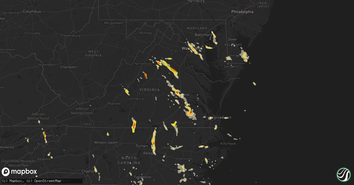
Hail Map on July 19, 2016
Get this storm
July 19 map
$229
one time, instant access
Download today. No call, no setup
Keep the $229
Bought the map and want the full workflow? Apply the entire $229 to a subscription within 7 days. None of it is wasted.
Every map, not just this one
This buys you this map. Subscription and you get every map we run, in the markets you choose from a few cities to whole states to nationwide. Plus real-time alerts the moment a storm fires.
Contact data
Name, contact info, occupancy, even credit band for addresses in the footprint. You go from where it hit to who to call.
Become the source they trust
Unlimited branding weather history reports on demand. You already have the documented answer ready for the property owner, and you are the one who showed up with it.
Property data and RoofTrace estimates
Pull up any address you have got, its value and the exact code rules for that jurisdiction, straight from One Click Code. Then RoofTrace estimates the squares, pitch, and roof value, priced the way you price.
States Impacted by Hail Map on July 19, 2016
Storm reports
Tennessee
| Date | Description |
|---|---|
| 07/19/20164:18 PM CDT | Twitter photo of tree blown down in bells bend |
| 07/19/20163:50 PM CDT | Pictures of trees down. |
| 07/19/20163:30 PM CDT | Reports of trees down on burt burgen road. |
| 07/19/20163:03 PM CDT | Tree and power line down on denny road in clarksville |
| 07/19/20163:00 PM CDT | Facebook photo of tree down on clearview drive in clarksville. Time estimated based on radar. |
| 07/19/20163:00 PM CDT | Facebook photo shows tree down on port cleburne lane in hermitage. Time estimated based on radar. |
| 07/19/20163:00 PM CDT | Several trees down near briceville... Tennessee. |
| 07/19/20162:55 PM CDT | Golfball size hail at sulphur springs... Tennessee. |
| 07/19/20162:45 PM CDT | Large equipment barn blown down and trees down near alexandria. Time and location estimated based on radar. |
| 07/19/20162:35 PM CDT | A local report indicates 1.00 inch wind near GRAY |
| 07/19/20162:30 PM CDT | A local report indicates 1.00 inch wind near MOHAWK |
| 07/19/20162:30 PM CDT | Several trees down near mohawk. |
| 07/19/20162:24 PM CDT | Numerous reports of trees and limbs down and some power outages in gainesboro. |
| 07/19/20162:12 PM CDT | Twitter pictures of three large trees down on brush creek circle. |
| 07/19/20162:10 PM CDT | Tree snapped and fell through home in mount juliet. Time and location estimated based on radar. |
| 07/19/20162:09 PM CDT | Reports of multiple large trees down 1-2 feet in diameter at davis drive between oden ct and hood place. |
| 07/19/20162:00 PM CDT | Reports of multiple large trees down 1-2 feet in diameter at davis drive between oden ct and hood place. Trees also down on wilson pike. |
| 07/19/20161:59 PM CDT | Tree down across the road at 9215 old smyrna road. |
| 07/19/20161:54 PM CDT | Several reports of trees down and powerlines down throughout the city of brentwood. Tree on house on oden court... Brushboro drive... Wires down on davis drive. |
Iowa
| Date | Description |
|---|---|
| 07/19/20163:30 PM CDT | . |
| 07/19/20163:05 PM CDT | Strong wind blew law enforcement car off the road. |
| 07/19/20163:04 PM CDT | Tornado on the ground at 3:04 pm . |
| 07/19/20162:50 PM CDT | Law enforcement reported 12 inch diameter trees downed in centerville. Time and location estimated from radar. Delayed report. |
| 07/19/20162:48 PM CDT | 8-10 inch diameter tree limbs blown out of trees. |
| 07/19/20162:43 PM CDT | Law enforcement reported trees down in mystic. Time and location estimated from radar. Delayed report. |
| 07/19/20162:40 PM CDT | 8-10 inch diameter tree limbs blown out of trees. |
| 07/19/20162:40 PM CDT | Brief tornado touchdown about 3 miles north of melrose. |
| 07/19/20162:37 PM CDT | 8-10 inch diameter tree limbs blown out of trees. |
| 07/19/20162:35 PM CDT | Law enforcement reported trees down near 527th ave on the ne side of melrose. Time estimated from radar. Delayed report. |
| 07/19/20162:20 PM CDT | Trained spotter reported grain bin damage... Including one rolled up against another... Completely removed fence posts... And tree damage. Time radar estimated. |
| 07/19/20162:20 PM CDT | Trained spotter reported damaged brick and concrete silos... Barn damage... Roof damage... And tree damage on farmstead. Time radar estimated. . |
| 07/19/20162:20 PM CDT | Also a few small tree limbs broken off tree. Wind occurred between 220 and 230 pm. |
| 07/19/20162:20 PM CDT | Apartment damaged and trees down in chariton. Time estimated by radar. |
| 07/19/20162:00 PM CDT | Law enforcement reported downed trees up to 24 inches between lacona and milo. Time and location estimated from radar. Delayed report. . |
| 07/19/201612:20 PM CDT | . |
| 07/19/201611:29 AM CDT | Roof lifted off a barn. |
| 07/19/201611:27 AM CDT | Tree fell on car on highway 59. No injuries. |
| 07/19/201611:26 AM CDT | A local report indicates 58 MPH wind near 2 S HARLAN |
Montana
| Date | Description |
|---|---|
| 07/19/20166:59 PM CDT | 58 mph thunderstorm wind gust near york road and wylie drive. |
| 07/19/20166:59 PM CDT | 58 mph wind gust near the intersection of york road and wylie drive. |
| 07/19/20166:22 PM CDT | Mesonet station mosby 16ene/lufborough hill /mtluf/. |
| 07/18/201611:46 PM CDT | Delayed report of 78 mph gust. |
| 07/18/201611:12 PM CDT | 58 mph wind gust at the havre airport. |
| 07/18/20169:37 PM CDT | Multiple public reports of quarter-sized hail near intersection of hwy 93 and 82. Small twigs and leaves down. Very heavy rain. |
| 07/18/20168:57 PM CDT | Delayed report. |
| 07/18/20168:05 PM CDT | A local report indicates 70 MPH wind near DUCK CREEK FISHING ACCE |
| 07/18/20167:44 PM CDT | Mesonet station king coulee /kigm8/. |
Maryland
| Date | Description |
|---|---|
| 07/18/201611:32 PM CDT | Trees down near intersection of hunting creek road and huntingtown road |
| 07/18/201611:00 PM CDT | Tree down on woodyard road at sherwood drive |
| 07/18/20169:35 PM CDT | Two large trees down at the intersection of river rd and goldsboro rd |
| 07/18/20169:29 PM CDT | Numerous trees down in far southern portion of the county. |
| 07/18/20169:28 PM CDT | A local report indicates 1.00 inch wind near 1 SSE CHEVY CHASE VIEW |
| 07/18/20169:20 PM CDT | Multiple large oak trees down |
Georgia
| Date | Description |
|---|---|
| 07/19/20166:47 PM CDT | A local report indicates 1.00 inch wind near STONE MOUNTAIN |
| 07/19/20166:40 PM CDT | Trees snapped or uprooted. |
| 07/19/20166:12 PM CDT | Trees down in the dixie area |
| 07/19/20166:12 PM CDT | Trees down in the barwick area |
| 07/19/20165:58 PM CDT | At least 6 trees down across sw part of county along with initial reports of large hail. |
| 07/19/20165:50 PM CDT | Tree down |
| 07/19/20165:44 PM CDT | Two trees down along coweta heard rd. |
| 07/19/20165:40 PM CDT | Multiple reports of quarter size hail near intersection of lafayette pkwy and s. Davis rd. Also numerous trees down county wide with some on homes. |
| 07/19/20165:40 PM CDT | Multiple reports of quarter size hail near intersection of lafayette pkwy and s. Davis rd. Also numerous trees down county wide with some on homes. |
| 07/19/20165:30 PM CDT | Tree down |
| 07/19/20165:18 PM CDT | Multiple trees down along with others reported across the county. |
| 07/19/20165:10 PM CDT | Multiple trees down |
| 07/19/20165:05 PM CDT | Several trees and power lines down |
| 07/19/20165:00 PM CDT | Trees down |
| 07/19/20165:00 PM CDT | Several trees down north and northeast of valdosta |
| 07/19/20164:52 PM CDT | Wrdw-tv reported trees down in the crawford mills neighborhood in grovetown near brookwood elementary school... Including tree down on interstate 20 near mile marker 19 |
| 07/19/20164:50 PM CDT | Several trees down... Some on power lines |
| 07/19/20164:40 PM CDT | A tree was blown down in davisboro. |
| 07/19/20164:35 PM CDT | Multiple trees down in the senoia and haralson areas. |
| 07/19/20164:31 PM CDT | Several trees down and up to quarter size hail with power outage. |
| 07/19/20164:31 PM CDT | Several trees down and up to quarter size hail with power outage. |
| 07/19/20164:30 PM CDT | One tree was blown down in louisville. |
| 07/19/20164:20 PM CDT | 1 tree down at 5500 hwy 41 north |
| 07/19/20164:15 PM CDT | Dispatch reported a tree down on ben carver road. Timing estimated by radar. |
| 07/19/20163:55 PM CDT | Dispatch reported two trees down near the intersection of harper lane and trace circle. Timing estimated by radar. |
| 07/19/20163:52 PM CDT | ...corrected time... Wrdw-tv reported trees down in the crawford mills neighborhood in grovetown near brookwood elementary school... Including tree down on interstate 2 |
| 07/19/20163:40 PM CDT | Coffee county 911/dispatch reports a large tree downed by strong wind gusts along westgreen road in douglas. Time of damage based on radar data. |
| 07/19/20163:35 PM CDT | Several trees were blown down in buckhead. |
| 07/19/20163:35 PM CDT | Coffee county 911/dispatch reports a large tree downed by strong wind gusts in broxton. Time of damage based on radar data. |
| 07/19/20163:35 PM CDT | 1 tree down |
| 07/19/20163:10 PM CDT | Power outage west of cuthbert was due to winds from thunderstorm |
| 07/19/20162:45 PM CDT | Power outage near graves due to winds from thunderstorm |
| 07/19/20162:30 PM CDT | Several trees down reported by quitman county sheriffs office |
| 07/18/20167:09 PM CDT | *** 1 fatal... 1 inj *** strong winds from a thunderstorm caused a large tree to fall on a parked car killing the adult male passenger and injuring the teenage male pas |
Delaware
| Date | Description |
|---|---|
| 07/19/20162:26 AM CDT | A local report indicates 65 MPH wind near DEWEY BEACH |
| 07/19/20162:16 AM CDT | A local report indicates 58 MPH wind near DEWEY BEACH |
Florida
| Date | Description |
|---|---|
| 07/19/20165:25 PM CDT | Tree down |
| 07/19/20165:20 PM CDT | Tree down |
| 07/19/20165:20 PM CDT | Quarter size hail reported |
| 07/19/20165:20 PM CDT | Power line down |
North Carolina
| Date | Description |
|---|---|
| 07/19/20166:44 PM CDT | Thunderstorm winds downed two trees along country club road. |
| 07/19/20166:15 PM CDT | Several small trees down on fruit ridge road south of highway 74 business |
| 07/19/20166:12 PM CDT | Several large oak trees down in the central part of the city. |
| 07/19/20165:48 PM CDT | Thunderstorm winds resulted in numerous trees down within the community of walnut cove. |
| 07/19/20165:44 PM CDT | Thunderstorm winds resulted in at least two trees down temporarily cloising roads between danbury and germanton nc. |
| 07/19/20165:40 PM CDT | One tree down on rocky ridge sims road near luther road. |
| 07/19/20165:35 PM CDT | Thunderstorm winds resulted in several trees down within the community of meadows in stokes county... Nc. |
| 07/19/20165:35 PM CDT | Thunderstorm winds resulted in at least two trees down temporarily cloising roads between danbury and germanton nc. |
| 07/19/20164:52 PM CDT | 2 trees down off midway road between boat lane and zachary path |
| 07/19/20164:35 PM CDT | Onslow county 911 reported a tree down across piney green road. Time based on radar. |
| 07/19/20164:15 PM CDT | Trees and power lines down on mill creek road near the intersection with graphite road. Time determined from radar data. |
| 07/19/20163:35 PM CDT | Several trees down on cottonwood lane |
| 07/19/20163:01 PM CDT | Tree down across the road at the intersection of wintergreen and loop rd. In cove city. |
| 07/19/20162:49 PM CDT | Public reported dime to quarter size hail near quinerly crossroads east of grifton. |
| 07/19/20161:12 PM CDT | Intersection of gordon rd and market st. |
| 07/19/201612:30 PM CDT | Tree down on adams creek rd. In havelock |
| 07/19/201611:12 AM CDT | A couple trees blown down on lanier ln. |
| 07/19/201611:10 AM CDT | Trees blown down and blocking morgan mill rd near deese rd. |
| 07/19/201611:04 AM CDT | Spotter reports tree on vehicle at rosemont ave and south main st. |
| 07/19/201610:50 AM CDT | A local report indicates 59 MPH wind near NEW RIVER |
| 07/19/20167:46 AM CDT | Report of tree down in ponzer area |
| 07/18/201611:12 PM CDT | A couple trees blown down on lanier ln. |
| 07/18/201611:10 PM CDT | Trees blown down and blocking morgan mill rd near deese rd. |
| 07/18/201611:06 PM CDT | Tree blown down over snatchburg rd. Time radar estimated. |
| 07/18/201611:05 PM CDT | Hoke county office of ncdot reports that several fallen trees had to be cleared from county roadways. |
| 07/18/201611:04 PM CDT | Spotter reports tree on vehicle at rosemont ave and south main st. |
| 07/18/201611:03 PM CDT | A tree was blown down on a power line which began to arc. |
| 07/18/201610:45 PM CDT | Trees and powerlines down along rankin street. |
| 07/18/201610:44 PM CDT | Section of siding was blown off house. Penny size hail. |
| 07/18/201610:42 PM CDT | Spotter reports trees blown down blocking roadway at mt olivet rd and cemetary st. |
| 07/18/201610:09 PM CDT | Fire dept reports three trees and power lines blown down on pharr mill rd. |
| 07/18/201610:08 PM CDT | Multiple reports of trees and power lines knocked down along hickory ridge rd and around morrison rd. |
| 07/18/20169:52 PM CDT | Tree blown down blocking rocky river road near lower rocky river rd. |
| 07/18/20169:40 PM CDT | Trees down on old knight road. Time approximated by radar. |
| 07/18/20169:35 PM CDT | Tree down. Time estimated by radar. |
| 07/18/20169:01 PM CDT | A tree and powerlines down on a residence. Time estimated by radar. |
| 07/18/20169:00 PM CDT | . |
| 07/18/20168:55 PM CDT | Tree down on powerlines. Time estimated by radar. |
| 07/18/20168:50 PM CDT | Tree down. Time estimated by radar. |
| 07/18/20168:48 PM CDT | Trees knocked down blocking fannie sloan rd near mooresville rd...road closed. Power pole snapped in half. |
| 07/18/20168:48 PM CDT | Trees blown down blocking fannie sloan rd near millbridge rd. Roadway is closed. |
| 07/18/20168:47 PM CDT | Trees blown down across powerlines at the intersection of mooresville rd and round tuit ln. |
| 07/18/20168:47 PM CDT | Power lines knocked down across mooresville rd. Moorseville rd has been closed. |
| 07/18/20168:45 PM CDT | Structural damage on tp rd |
| 07/18/20168:30 PM CDT | Large pine tree down on eastwood terrace. |
| 07/18/20168:12 PM CDT | Several trees down... Some on powerlines. Time estimated by radar. |
| 07/18/20167:20 PM CDT | Tree down on scott rd. Radar estimated time. |
| 07/18/20167:20 PM CDT | Tree down on shallowford rd at us 241. |
Colorado
| Date | Description |
|---|---|
| 07/19/20165:55 PM CDT | Awos station buena vista airport /aej/. |
North Dakota
| Date | Description |
|---|---|
| 07/19/20166:45 PM CDT | Report and photo posted via social media. |
| 07/19/20166:36 PM CDT | A tornado tracked for nearly a mile to about 3 ssw of nash by 639 pm cdt. The tornado snappe dor uprooted numerous trees along the middle fork of the park river. Maximu |
| 07/19/20166:35 PM CDT | Multiple large trees down or snapped |
| 07/19/20166:23 PM CDT | Sent via twitter |
| 07/19/20166:17 PM CDT | A tornado touched down in the south end of hoople and tracked to the southeast for about 1.5 miles through 621 pm cdt. The tornado broke down and scattered numerous lar |
| 07/19/20166:05 PM CDT | Sent via twitter. |
| 07/19/20165:55 PM CDT | Widespread crop damage produced by wind drivern hail across southern park and lodema townships. |
| 07/19/20165:40 PM CDT | Measured on a personal davis system |
| 07/19/20165:38 PM CDT | Numerous trees broken down around town. Several buildings with roof damage due to large hail and falling tree limbs. Wind and hail damage to farm fields is widespread a |
| 07/19/20165:35 PM CDT | Several large trees broken down near the tongue river. |
| 07/19/20165:30 PM CDT | A tornado tracked to the east southeast for roughly 5 miles to around 2 ene mountain by around 540 pm cdt. The snapped or uprooted numerous hardwood trees in shelter be |
| 07/19/20165:15 PM CDT | Trees broken down across the pembina hills wildlife area and north olga township. |
| 07/19/20165:05 PM CDT | Numerous large trees broken down and evidence of hail damage to crops in and around the pembina gorge area and fremont township. |
| 07/19/20164:58 PM CDT | Hailed for 15 minutes at highway 32 diner in walhalla |
| 07/19/20161:37 PM CDT | Quarter to half dollar sized hail near the bridge at oswalds bay. |
| 07/19/20161:08 PM CDT | A local report indicates 1.00 inch wind near 3 SE BRINSMADE |
| 07/18/20168:50 PM CDT | An apparent microburst occurred several minutes behind the passage of a southward moving thunderstorm gustfront. Several trees were snapped at residences and farmsteads |
| 07/18/20168:45 PM CDT | Two trees split and some shingles turned up. |
| 07/18/20168:35 PM CDT | Tree branches up to a foot in diameter broken down at 9th and chestnut. Some fenching blown down as well. |
| 07/18/20167:52 PM CDT | Sheet metal structure demolished. Photo posted via social media. Time estimated from radar. |
| 07/18/20167:30 PM CDT | Numerous trees were snapped or uprooted across walshville township. At least one wooden power pole was snapped along cr54 just west of the red river bridge. |
| 07/18/20167:18 PM CDT | Large mature trees broken down in shelter belts along cr2. |
| 07/18/20167:13 PM CDT | A local report indicates 70 MPH wind near 4 E MINTO |
| 07/18/20167:07 PM CDT | Estimated by firefighters in truck. |
| 07/18/20167:05 PM CDT | Peak wind measured at the grafton airport /kgaf/. |
South Carolina
| Date | Description |
|---|---|
| 07/19/20166:46 PM CDT | Colleton county dispatch reported hail slightly larger than quarters near crossing of indian creek rd and hudson mill rd. |
| 07/19/20165:32 PM CDT | Report submitted via facebook showing a large tree limb snapped near the shoppes at trolley on old trolly rd. Time estimated from radar |
| 07/19/20165:17 PM CDT | A tree was blown down along highway 601 near the tye branch road intersection. Time was estimated from radar data. |
| 07/19/20165:17 PM CDT | Jasper county 911 center reported a tree down along highway 601 near the tye branch road intersection. Time was estimated from radar data. |
| 07/19/20165:02 PM CDT | Broadcast media relayed a photo of a tree down close to a residence on sasportas lane. Time was estimated from radar data. |
| 07/19/20165:00 PM CDT | Broadcast media relayed a report they received via social media of two trees blown down in the ashborough neighborhood. One tree knocked drain gutters off a residence a |
| 07/19/20163:41 PM CDT | Trees in roadway hwy 441 at cotton acres road. |
| 07/19/20163:40 PM CDT | Observer also estimated 70 mph winds. 3 trees down in emerald lakes subdivision. |
| 07/19/20163:38 PM CDT | Trees in roadway queen chapel rd at foxworth mill rd. |
| 07/19/20163:18 PM CDT | Sc dot reported trees down at spring hill road at rembert chruch road. |
| 07/19/20163:02 PM CDT | Tree in roadway plank rd in ridge spring. |
| 07/19/20162:30 PM CDT | Trees down hwy 39 between sumter schoolhouse and spann roads. |
| 07/19/201612:24 AM CDT | Chesterfield highway department reported trees blocking the roadway on ousleydale rd. Time estimated by radar. |
| 07/18/20169:55 PM CDT | Numerous trees down near springfield near the intersection of sc hwy 3 and sc hwy 4 near the flea market. |
| 07/18/20169:55 PM CDT | Golf ball sized hail on edisto st in springfield. |
| 07/18/20167:53 PM CDT | Jasper county 911 center reported a tree down along the 7600 block of deerfield road. Time was estimated from radar data. |
Missouri
| Date | Description |
|---|---|
| 07/19/20165:15 PM CDT | Large tree fell on pickup truck on rte c btw rte bb and z. Tree blocking railroad tracks in town |
| 07/19/20165:10 PM CDT | Two power poles bent over highway 19 blocking roadway |
| 07/19/20164:55 PM CDT | Trees down blocking roads in town. |
| 07/18/20168:30 PM CDT | Fallen tree took down a power line |
| 07/18/20168:25 PM CDT | Tree limbs and several large trees down |
| 07/18/20168:25 PM CDT | Tree downed at riverview lane |
| 07/18/20168:25 PM CDT | Tree downed at perry cate and hannah drive |
Illinois
| Date | Description |
|---|---|
| 07/19/20166:50 PM CDT | Trees down in city |
| 07/19/20166:20 PM CDT | Large tree limb downed on the north side of pittsfield. Required city services to remove. |
| 07/19/20166:10 PM CDT | 5 to 6 trees downed on highway 99 |
| 07/19/20166:05 PM CDT | 2 trees downed |
| 07/19/20165:43 PM CDT | A local report indicates 62 MPH wind near 4 NE BURTON |
| 07/19/20165:31 PM CDT | A local report indicates 61 MPH wind near 4 NE BURTON |
| 07/19/20162:00 PM CDT | Trees and power lines down...reported by a viewer |
| 07/19/20161:55 PM CDT | Shingles blown off a roof and tree limbs down between cypress and belknap. Torrential rainfall... And pea to nickel sized hail estimated. |
| 07/19/20161:50 PM CDT | Large tree branches and power lines down in and around the community of cypress |
| 07/18/20169:40 PM CDT | Large tree uprooted at north charles street near il hwy 161. Numerous limbs down. |
| 07/18/20168:02 PM CDT | 2 large trees of 2-foot diameter blew down on powerlines in pawnee...tree had some rot to it. Estimated wind speed of 60 mph. |
| 07/18/20167:20 PM CDT | Trees down in city |
Virginia
| Date | Description |
|---|---|
| 07/19/20166:34 PM CDT | Trees and power lines down. |
| 07/19/20166:15 PM CDT | Tree down. Several branches down. |
| 07/19/20165:55 PM CDT | . |
| 07/19/20165:50 PM CDT | Several trees down around ivor. |
| 07/19/20165:35 PM CDT | Report of a corn field stripped by large hail on beaverdam rd near harrels mille pond. |
| 07/19/20165:25 PM CDT | Trees down along paris rd and dry bread rd. |
| 07/19/20165:20 PM CDT | Large tree branch across rt. 460 5 miles west of waverly. |
| 07/19/20165:15 PM CDT | Trees down along highway 460. Road is closed. . |
| 07/19/20165:00 PM CDT | Trees down along ruffin rd at sandy ridge rd. |
| 07/19/20165:00 PM CDT | Trees down along hines rd at webb rd. |
| 07/19/20164:30 PM CDT | Several large limbs down. |
| 07/19/20164:30 PM CDT | Numerous trees down. 2 trees on homes. Trees on power lines. |
| 07/19/20164:25 PM CDT | Large tree across strath rd. Near kinvan. |
| 07/19/20164:25 PM CDT | Tree down near darbytown rd. |
| 07/19/20164:25 PM CDT | Large trees down in screamersville near enon church and central ave. Large limbs caused roof damage. . |
| 07/19/20164:24 PM CDT | Tree blocking new market rd. Large limbs down. |
| 07/19/20164:20 PM CDT | Tree across southbury ave. |
| 07/19/20164:10 PM CDT | . |
| 07/19/20164:09 PM CDT | . |
| 07/19/20164:05 PM CDT | Tree down on home. |
| 07/19/20164:05 PM CDT | Trees down at britton rd and darbytown rd. |
| 07/19/20164:05 PM CDT | Tree on home in forest hill. . |
| 07/19/20164:00 PM CDT | Tree down across labernum ave. Large tree limbs and branches down. |
| 07/19/20164:00 PM CDT | Large limbs down. Nickel size hail. |
| 07/19/20164:00 PM CDT | Trees down near chippenham pkwy north of hull st. Rd. |
| 07/19/20164:00 PM CDT | Large limbs down. |
| 07/19/20163:58 PM CDT | Trees uprooted and snapped about 2 miles southeast of the university of richmond . |
| 07/19/20163:55 PM CDT | . |
| 07/19/20163:50 PM CDT | Several large limbs down. |
| 07/19/20163:50 PM CDT | Partial roof collapse of the latino market on oak glenn rd. |
| 07/19/20163:50 PM CDT | 911 dispatch is reporting numerous trees down in the city of richmond especially across the south side. . |
| 07/19/20163:45 PM CDT | Trees down on powhite parkway near the tolls. |
| 07/19/20163:30 PM CDT | . |
| 07/19/20163:30 PM CDT | Quarter size hail at patterson and lauderdale. |
| 07/19/20163:30 PM CDT | . |
| 07/19/20163:20 PM CDT | A local report indicates 1.00 inch wind near 1 SE GLASGOW |
| 07/19/20163:15 PM CDT | Tree down on cross county rd. Near i-64. |
| 07/19/20163:15 PM CDT | Trees down along manakin rd and dogwood trail. . |
| 07/19/20162:55 PM CDT | Trees down along with a power line near louisa. . |
| 07/19/20162:55 PM CDT | Trees down on i-64 near oilville. |
| 07/19/20162:55 PM CDT | Tree down on cross county rd. Near i-64. |
| 07/19/20162:38 PM CDT | A local report indicates 1.00 inch wind near ENE BIG ISLAND |
| 07/19/20162:22 PM CDT | A local report indicates 1.00 inch wind near 3 SW SNELL |
| 07/19/20162:05 PM CDT | Lasted about 2 minutes |
| 07/19/20162:05 PM CDT | Thunderstorm winds resulted in a tree down within the community of glasgow... Va. |
| 07/19/20162:02 PM CDT | Tree down near intersection of forge road and amberwoods drive |
| 07/19/20161:58 PM CDT | Thunderstorm winds resulted in a tree down at the intersection of forge road and shepards run. |
| 07/19/20161:55 PM CDT | About 8 trees down along ruth rd in scattered locations including near intersection of ruth rd and thrift rd |
| 07/19/20161:52 PM CDT | Tree down on power lines near tatum rd and lawyers rd |
| 07/19/20161:45 PM CDT | A local report indicates 1.00 inch wind near PARKER |
| 07/19/20161:43 PM CDT | A local report indicates 1.00 inch wind near 1 WSW LOCUST GROVE |
| 07/19/20161:33 PM CDT | Trees down at 500 block of n seminole trail |
| 07/19/20161:25 PM CDT | Thunderstorm winds resulted in one tree down near the natural bridge safari park. |
| 07/19/20161:25 PM CDT | Trees down at ridgeview road and w hoover road |
| 07/19/20161:24 PM CDT | Several trees down also |
| 07/19/20161:24 PM CDT | A local report indicates 1.00 inch wind near 2 WSW OPAL |
| 07/19/20161:10 PM CDT | Couple trees down. |
| 07/19/20161:05 PM CDT | Rt 686 and hwy 15 |
| 07/19/20161:00 PM CDT | Several trees down near natural tunnel state park. |
| 07/19/20161:00 PM CDT | A local report indicates 1.00 inch wind near 4 WSW CULPEPER |
| 07/18/201611:44 PM CDT | Quarter size hail |
| 07/18/201610:48 PM CDT | Tree and power line down on river rd. Time radar estimated |
| 07/18/201610:45 PM CDT | Hail up to golf ball size reported in sutherlin |
| 07/18/201610:30 PM CDT | Tree down on a house. Time radar estimated. |
| 07/18/201610:30 PM CDT | Tree down on 15000 block of mountain rd. Time radar estimated |
| 07/18/201610:24 PM CDT | Tree down on ball park loop |
| 07/18/20169:30 PM CDT | Tree down on king cross rd near 360 |
Alabama
| Date | Description |
|---|---|
| 07/19/20164:10 PM CDT | Ema received several reports of trees and powerlines down near the intersection of mt. Moriah rd and shiloh church rd. |
| 07/19/20164:10 PM CDT | The roof was blown off a chicken house near the intersection of mt. Moriah rd and lake gerald rd. |
| 07/19/20163:37 PM CDT | Tim roof torn off a building and damaged a vehicle along county road 329 in geraldine. |
New Mexico
| Date | Description |
|---|---|
| 07/18/201611:34 PM CDT | A thunderstorm outflow produced a wind gust of 61 mph at the t or c airport. |
Minnesota
| Date | Description |
|---|---|
| 07/18/201610:50 PM CDT | A few trees down around north end of cass lake. Nearby rwis station along u.s highway 2 reported peak winds to 60 mph. |
| 07/18/201610:50 PM CDT | A few large tree branches and limbs broken down. |
| 07/18/201610:45 PM CDT | Valvoline highway sign blown down along mn highway 197. |
| 07/18/201610:45 PM CDT | Valvoline highway sign blown down along mn highway 197. |
| 07/18/201610:18 PM CDT | Widespread tree damage and power outages reported across northern bemidji. |
| 07/18/20169:45 PM CDT | A local report indicates 1.00 inch wind near 10 NNW BEMIDJI |
| 07/18/20169:20 PM CDT | Trees broken down near irvine ave and arctic road. |
| 07/18/20169:19 PM CDT | A few large tree branches and limbs broken down around town. |
| 07/18/20169:15 PM CDT | Large hail and torential rains... Followed by damaging winds. |
| 07/18/20169:14 PM CDT | A tornado partially wrapped in heavy rains and downburst winds tracked to the east southeast for roughly 4 miles ...to around 4 ene of puposky and the buena vista state |
| 07/18/20169:10 PM CDT | Numerous large tree branches and limbs broken down around town. Large sections of roofing peeled off of a warehouse on the south side of town. Peak winds estimated at 8 |
| 07/18/20169:00 PM CDT | A few dime to quarter sized hail and broken tree branches near the gully wildlife management area. |
| 07/18/20168:55 PM CDT | A tornado tracked intermittently for roughly 5 miles to around 2 se dorothy by 910 pm cdt. The tornado broke down numerous large trees in shelter belts... Rolled a hors |
| 07/18/20168:40 PM CDT | A few large tree branches and limbs broken down at a farmstead. |
| 07/18/20168:30 PM CDT | A local report indicates 1.25 inch wind near 4 WSW ISLAND LAKE |
| 07/18/20168:29 PM CDT | Mainly dime to nickel... With a few quaurter sized hail. Very heavy rains. |
| 07/18/20168:28 PM CDT | Large tree branches up to 12 inch diameter broken down in the mn state park. |
| 07/18/20168:25 PM CDT | Peak winds measured at the rwis station along highway 2. |
| 07/18/20168:15 PM CDT | Measured at a personal weather station. |
| 07/18/20167:40 PM CDT | Numerous trees snapped or uprooted in sheter belts and several field striped with wind driven hail...across northern and central higdem township. |
| 07/18/20167:38 PM CDT | Hail from ping pong ball to tennis ball sized feel across northern higdem township. |
| 07/18/20167:35 PM CDT | Tree uprooted onto a house roof. |
| 07/18/20167:35 PM CDT | Numerous trees snapped or uprooted around town and across southern oak park township. Wind driven hail striped several fields bare along and south of mn state highway 1 |
District of Columbia
| Date | Description |
|---|---|
| 07/18/201610:40 PM CDT | Straight path of tree damage across the mall near the washington monument. |
| 07/18/201610:05 PM CDT | Quarter sized hail at nationals park |
| 07/18/201610:03 PM CDT | A local report indicates 1.25 inch wind near 1 E WASHINGTON |
| 07/18/201610:02 PM CDT | A local report indicates 1.75 inch wind near 1 ESE US CAPITOL |
| 07/18/201610:02 PM CDT | Quarter size hail near intersection of 9th st nw and e st nw |
| 07/18/20169:59 PM CDT | Several trees down near the ellipse |
| 07/18/20169:58 PM CDT | Quarter size hail at intersection of 6th st ne and l st ne |
| 07/18/20169:57 PM CDT | A local report indicates 1.50 inch wind near 1 N THE WHITE HOUSE |
| 07/18/20169:40 PM CDT | Large tree down on home and vehicle in the 4700 block of quebec street |
Idaho
| Date | Description |
|---|---|
| 07/18/20169:52 PM CDT | Downed trees and minor flooding reported on main street. . |
| 07/18/20169:50 PM CDT | . |
| 07/18/20168:52 PM CDT | Downed trees and minor flooding reported on main street. . |
| 07/18/20168:50 PM CDT | . |
Wyoming
| Date | Description |
|---|---|
| 07/19/20163:13 PM CDT | Greybull airport /gey/. |
Oregon
| Date | Description |
|---|---|
| 07/18/20168:30 PM CDT | 12 large trees downed along fence line creek road. Observed 1 inch hail in diameter 15 hours after storm. Hail destroyed a canvas tent and damaged a horse trailer and f |
Cities Impacted by Hail Map on July 19, 2016
- Jonesborough, TN
- Pinehurst, GA
- Vienna, GA
- Sutherlin, VA
- Ringgold, VA
- Vienna, MD
- Stuarts Draft, VA
- Lyndhurst, VA
- Sterling, CO
- Fleming, CO
- Hawkinsville, GA
- Perry, GA
- Frostproof, FL
- Belhaven, NC
- Scranton, NC
- Moyock, NC
- De Soto, GA
- Leesburg, GA
- Musselshell, MT
- Stapleton, GA
- Blythe, GA
- Wrens, GA
- Matthews, GA
- Dearing, GA
- Augusta, GA
- Centreville, MD
- Goodridge, MN
- Saint Thomas, ND
- Hensel, ND
- Grafton, ND
- Crystal, ND
- Hoople, ND
- Disputanta, VA
- Sac City, IA
- Lytton, IA
- Fall Branch, TN
- Ocheyedan, IA
- Big Sandy, MT
- Zebulon, NC
- Knightdale, NC
- Oxford, NC
- Kittrell, NC
- Wendell, NC
- Wake Forest, NC
- Raleigh, NC
- Youngsville, NC
- Franklinton, NC
- Rolesville, NC
- Henderson, NC
- Lakefield, MN
- Clarks Hill, SC
- Fort Dodge, IA
- Mauk, GA
- Box Springs, GA
- Ivanhoe, NC
- Chinook, MT
- Queenstown, MD
- Allison, IA
- Bishopville, SC
- Willacoochee, GA
- Walhalla, ND
- Atlanta, GA
- Fairburn, GA
- Chevy Chase, MD
- Washington, DC
- Bethesda, MD
- Melville, MT
- Sumter, SC
- Dalzell, SC
- Union, OR
- Roundup, MT
- Portsmouth, IA
- Kershaw, SC
- Bethune, SC
- Cunningham, TN
- Telford, TN
- Bemidji, MN
- Eufaula, AL
- Duffield, VA
- Midland, NC
- Harrisburg, NC
- Concord, NC
- Charlotte, NC
- Stanley, ND
- Minto, ND
- Alvarado, MN
- Warren, MN
- Oslo, MN
- East Grand Forks, MN
- Bowie, MD
- Laurel, MD
- Beltsville, MD
- Adel, GA
- Estherville, IA
- Norway, SC
- Neeses, SC
- Springfield, SC
- Pine Lake, GA
- Decatur, GA
- Lithonia, GA
- Stone Mountain, GA
- Roper, NC
- Shevlin, MN
- Rochelle, VA
- Pratts, VA
- Madison, VA
- Aroda, VA
- Greentop, MO
- Queen City, MO
- Wataga, IL
- New Athens, IL
- Rhoadesville, VA
- Locust Grove, VA
- Spotsylvania, VA
- Supply, NC
- Richmond, VA
- Henrico, VA
- Boulder, CO
- Puposky, MN
- Westside, IA
- Vail, IA
- Jennings, FL
- Woodlawn, TN
- Franklin, VA
- Hyattsville, MD
- Brentwood, MD
- Riverdale, MD
- Fort Benning, GA
- Oglethorpe, GA
- Andersonville, GA
- Ideal, GA
- Russellville, TN
- Morristown, TN
- Maple Hill, NC
- Cove City, NC
- Swanquarter, NC
- Florence, SC
- Effingham, SC
- Edinburg, ND
- Walnut Cove, NC
- Sheffield, IA
- Hampton, IA
- Annapolis, MD
- Edgewater, MD
- Stevensville, MD
- Abingdon, IL
- Cando, ND
- Leeds, ND
- Gallatin, MO
- Hogansville, GA
- Pollocksville, NC
- Maysville, NC
- Fort Stewart, GA
- Hartsville, SC
- Society Hill, SC
- Patrick, SC
- Fort Bragg, NC
- Southern Pines, NC
- Jameson, MO
- Jamesport, MO
- Ruffin, SC
- Walterboro, SC
- Gainesboro, TN
- Roopville, GA
- Red Springs, NC
- Lumber Bridge, NC
- Shannon, NC
- Madison, FL
- Pearson, GA
- Axson, GA
- Shawmut, MT
- Kingston, MO
- Hamilton, MO
- Dover, NC
- Grifton, NC
- Ayden, NC
- Lancaster, MO
- Glenwood, MO
- Portsmouth, VA
- Bolivia, NC
- Bolton, NC
- Southport, NC
- Wilmington, NC
- Oak Island, NC
- Winnabow, NC
- Leland, NC
- Ash, NC
- Hopewell, VA
- Geyser, MT
- Prole, IA
- Saint Charles, IA
- Saint Pauls, NC
- Kinston, NC
- Tarboro, NC
- Lucas, IA
- Valdosta, GA
- Gonvick, MN
- Culpeper, VA
- Mitchells, VA
- Boston, VA
- Broadview, MT
- Rehoboth Beach, DE
- Oxon Hill, MD
- Fort Myer, VA
- Glen Echo, MD
- Arlington, VA
- Clinton, MD
- Naval Anacost Annex, DC
- Suitland, MD
- Temple Hills, MD
- Andrews Air Force Base, MD
- Cabin John, MD
- Van Meter, IA
- Brightwood, VA
- Etlan, VA
- Banco, VA
- Haywood, VA
- Reva, VA
- Syria, VA
- Lumberton, NC
- Senoia, GA
- Long Creek, OR
- Monument, OR
- Sciota, IL
- Blandinsville, IL
- Macomb, IL
- Shellman, GA
- Center, MO
- Woodbury, TN
- Readyville, TN
- Barnesville, GA
- Milner, GA
- East Saint Louis, IL
- Belleville, IL
- Buchanan, GA
- Maxton, NC
- Pembroke, NC
- Chambersburg, IL
- Griggsville, IL
- Elkton, VA
- Stanley, VA
- Celina, TN
- Whitleyville, TN
- Hilham, TN
- Norfolk, VA
- Ewing, MO
- Melrose, IA
- Russell, IA
- Chariton, IA
- Lovilia, IA
- Pineland, SC
- Delta, AL
- Lineville, AL
- Brayton, IA
- Exira, IA
- Varnville, SC
- Indianola, IA
- Lacona, IA
- Milo, IA
- Liberty Center, IA
- Montrose, GA
- Cochran, GA
- Chester, GA
- Danville, GA
- Windsor, NC
- Merry Hill, NC
- Westphalia, IA
- Harlan, IA
- Kirkman, IA
- Earling, IA
- Lewes, DE
- Millsboro, DE
- Bethany Beach, DE
- Wallowa, OR
- Petersburg, VA
- Chesterfield, VA
- Williamson, IA
- Chauncey, GA
- Nemaha, IA
- Newell, IA
- Fonda, IA
- Suffolk, VA
- Kingsport, TN
- Kenly, NC
- Lucama, NC
- Stites, ID
- Elko, GA
- Browning, IL
- Astoria, IL
- Braymer, MO
- Clear Lake, IA
- Thornton, IA
- Leonard, MN
- Redlake, MN
- Louisville, GA
- Waverly, VA
- Spring Grove, VA
- Falls Church, VA
- Rockwell City, IA
- Lake City, IA
- Spencer, IA
- Dickens, IA
- West Blocton, AL
- Langdon, ND
- Schaller, IA
- Galva, IA
- Cumming, IA
- Norwalk, IA
- Old Fort, NC
- Black Mountain, NC
- Abbeville, AL
- Gilmore City, IA
- Palmer, IA
- Pocahontas, IA
- Somers, IA
- Midlothian, VA
- Peshastin, WA
- Unionville, VA
- Mohawk, TN
- Bybee, TN
- Jackson, MN
- Rocky Mount, NC
- Imnaha, OR
- Headland, AL
- Newville, AL
- Washington, NC
- Moreland, GA
- Luthersville, GA
- Grantville, GA
- Greenville, GA
- Newnan, GA
- Gay, GA
- Salisbury, MD
- Dixie, GA
- Quitman, GA
- Pamplico, SC
- Pembroke, GA
- Weldon, IA
- Carlyle, IL
- Sandoval, IL
- Powhatan, VA
- Minnewaukan, ND
- Churchs Ferry, ND
- Devils Lake, ND
- Penn, ND
- Glasgow, VA
- Buena Vista, VA
- Natural Bridge, VA
- Monroe, VA
- Big Island, VA
- Bedford, VA
- Natural Bridge Station, VA
- Morganton, NC
- Otis, CO
- Akron, CO
- Harrington, DE
- Felton, DE
- Red Lake Falls, MN
- Manakin Sabot, VA
- Rockville, VA
- Chesapeake, VA
- Enterprise, OR
- Booneville, AR
- Winkelman, AZ
- Lagrange, GA
- Grand Forks, ND
- Battle Creek, IA
- Holstein, IA
- Coatsville, MO
- Bloomfield, IA
- Moulton, IA
- Bullock, NC
- Clayton, NC
- Claxton, GA
- Manvel, ND
- Blackduck, MN
- Swansboro, NC
- South Boston, VA
- Alton, VA
- Keeling, VA
- Glen Allen, VA
- Georgetown, DE
- Alexandria, VA
- Fort Washington, MD
- Santa Fe, MO
- Paris, MO
- Thompson, MO
- Woodland, GA
- Talbotton, GA
- Stanford, MT
- Blackville, SC
- Mineral, VA
- Chestertown, MD
- Ida Grove, IA
- Wilsons, VA
- Cottonwood, ID
- Catherine, AL
- Lake Wales, FL
- Partlow, VA
- Ruther Glen, VA
- Wakefield, VA
- Ivor, VA
- Marion, SC
- Englewood, CO
- Lake View, IA
- Bath, IL
- Tenstrike, MN
- Vanceboro, NC
- Hookerton, NC
- Trenton, NC
- Brevard, NC
- Rosman, NC
- Sunset, SC
- Greenfield, TN
- Hampton, GA
- Griffin, GA
- Pearisburg, VA
- Leary, GA
- Godfrey, IL
- Dow, IL
- Buckhead, GA
- Milton, NC
- Chatham, VA
- Vernon Hill, VA
- Yanceyville, NC
- Leasburg, NC
- Java, VA
- Semora, NC
- Blanch, NC
- Massena, IA
- Coffee Creek, MT
- Geraldine, MT
- Ruthven, IA
- Lugoff, SC
- Cadwell, GA
- Sperryville, VA
- Myrtle Beach, SC
- Novelty, MO
- Rock Hall, MD
- Gunpowder, MD
- Butler, AL
- Clearbrook, MN
- Crozet, VA
- Mount Ulla, NC
- Cleveland, NC
- Lamar, SC
- Deer Lodge, TN
- Hobgood, NC
- Battleboro, NC
- Whitakers, NC
- Winnett, MT
- Oilville, VA
- Greenville, IL
- Thomasville, AL
- Knoxville, IA
- Crozier, VA
- Versailles, IL
- Mount Sterling, IL
- Odum, GA
- Garland, NC
- Elizabethtown, NC
- Raeford, NC
- Woodburn, IA
- Thomaston, GA
- Hahira, GA
- Latimer, IA
- Coulter, IA
- Longs, SC
- Kevil, KY
- La Center, KY
- Prince George, VA
- Nashville, GA
- Waynesboro, VA
- Crimora, VA
- Sharpsburg, GA
- Perry, FL
- Roseville, IL
- Good Hope, IL
- Pennington, MN
- Dumont, IA
- Lostine, OR
- Black Hawk, CO
- Molt, MT
- Whiteville, NC
- Shelbyville, MO
- Garysburg, NC
- Bowdon, GA
- Franklin, GA
- Brodnax, VA
- La Crosse, VA
- South Hill, VA
- Monroe City, MO
- Naylor, GA
- Watertown, TN
- Alexandria, TN
- Maidens, VA
- Bumpass, VA
- Montpelier, VA
- Pine, CO
- Bailey, CO
- Conifer, CO
- Milford, IA
- Dawson, GA
- Rembert, SC
- Polk City, FL
- Lakeland, FL
- Laurel, DE
- Seaford, DE
- Rhodesdale, MD
- Bethel, DE
- Bogard, MO
- Potomac, MD
- Gaithersburg, MD
- Pell City, AL
- Washington, GA
- Fisher, MN
- Drayton, ND
- Cavalier, ND
- Grovetown, GA
- Hebron, MD
- Eolia, MO
- Thompson Falls, MT
- Surry, VA
- Bluffs, IL
- Butler, GA
- Fort Campbell, KY
- West Green, GA
- Herndon, KY
- Hopkinsville, KY
- Oak Grove, KY
- White Bird, ID
- Grangeville, ID
- Waterloo, IL
- Red Bud, IL
- Hecker, IL
- Windsor, VA
- Smithfield, VA
- Ridgeville, SC
- Sedley, VA
- Sanford, NC
- Hines, MN
- Grottoes, VA
- Americus, GA
- Graettinger, IA
- Jolley, IA
- Emporia, VA
- New London, MO
- Osceola, IA
- Saint Marys, IA
- Martensdale, IA
- New Virginia, IA
- Edina, MO
- Erwin, TN
- Louisa, VA
- Smithville, GA
- Leslie, GA
- Rapidan, VA
- Morgan, GA
- Belknap, IL
- Cypress, IL
- Cumberland Furnace, TN
- Islandton, SC
- House Springs, MO
- Wedowee, AL
- Pleasant Hill, NC
- Weldon, NC
- Gaston, NC
- Halifax, NC
- Havelock, NC
- Gate City, VA
- Leon, VA
- Oracle, AZ
- Bronwood, GA
- Stella, NC
- Lawrenceville, VA
- Warner Robins, GA
- New Bern, NC
- Brandywine, MD
- Huntingtown, MD
- Owings, MD
- Aquasco, MD
- Upper Marlboro, MD
- Alpha, MN
- West Point, VA
- Clayton, AL
- Fayetteville, NC
- Exline, IA
- Unionville, MO
- Pikeville, NC
- Fremont, NC
- Carrollton, MO
- Sims, NC
- Wilson, NC
- Creston, IA
- Climax, MN
- Waverly Hall, GA
- Greensboro, GA
- Udell, IA
- Centerville, IA
- Winchester, IL
- Cumberland, VA
- Farmville, VA
- Dillwyn, VA
- Reynolds, GA
- Milford, DE
- Nesmith, SC
- Woodbury, GA
- Renwick, IA
- Luray, VA
- Mount Vernon, GA
- Kilbourne, IL
- Easton, IL
- Vienna, IL
- Karnak, IL
- Ullin, IL
- Dongola, IL
- Galesburg, IL
- Bealeton, VA
- Warrenton, VA
- Jeffersonton, VA
- Remington, VA
- Rixeyville, VA
- Kila, MT
- Parkton, NC
- Gibson, GA
- Warrenton, GA
- Derby, IA
- Woodford, VA
- Meservey, IA
- Goodell, IA
- Tignall, GA
- Summerville, SC
- Ravenel, SC
- Pilot Rock, OR
- Soperton, GA
- Cuthbert, GA
- Knox City, MO
- Briceville, TN
- Georgetown, GA
- Gum Spring, VA
- McLean, VA
- Rockville, MD
- Cheltenham, MD
- Newington, GA
- Equality, AL
- Reynolds, ND
- Thompson, ND
- Patoka, IL
- Louisville, AL
- Macon, NC
- Ebony, VA
- Littleton, NC
- Bracey, VA
- Chester, MD
- Breda, IA
- Farnhamville, IA
- Gowrie, IA
- Paton, IA
- Churdan, IA
- Cullman, AL
- Vinemont, AL
- Barnardsville, NC
- Albany, GA
- Vass, NC
- Corwith, IA
- Philadelphia, MO
- Durham, MO
- Pleasantville, IA
- Barney, GA
- Tarrytown, GA
- Livonia, MO
- Cragford, AL
- Davidsonville, MD
- Harwood, MD
- Ackworth, IA
- Clarksville, TN
- Bethel, MO
- La Belle, MO
- Memphis, TN
- Prince Frederick, MD
- Marion, AR
- Pearce, AZ
- Columbia, TN
- Rentz, GA
- Dublin, GA
- Walnut, IA
- Garnett, SC
- Clyo, GA
- Tillman, SC
- Ridge Spring, SC
- Ward, SC
- Newport, NC
- Deloit, IA
- Ray City, GA
- Cameron, NC
- Coward, SC
- Scranton, SC
- Greenville, IA
- Royal, IA
- Jefferson, IA
- Ladson, SC
- Adrian, GA
- Swainsboro, GA
- Lakeland, GA
- Harcourt, IA
- Harbeson, DE
- Frankford, DE
- Ocean View, DE
- Fitzgerald, GA
- Kingston, GA
- Rome, GA
- Monticello, GA
- Mexico, MO
- Rutledge, MO
- Bradford, TN
- Cass Lake, MN
- Salley, SC
- Humeston, IA
- Garden Grove, IA
- Gracey, KY
- Unadilla, GA
- Ludlow, MO
- Norborne, MO
- Lignum, VA
- Beaverdam, VA
- Burr Hill, VA
- Jacksonville, NC
- Camden, SC
- Spirit Lake, IA
- Hurlock, MD
- Federalsburg, MD
- Bonaire, GA
- Kathleen, GA
- Bon Aqua, TN
- Lyles, TN
- Cincinnati, IA
- Fairfield, NC
- Melcher Dallas, IA
- Lula, GA
- Fenton, IA
- Lone Rock, IA
- Silver Spring, MD
- El Paso, TX
- Grand Junction, IA
- Dana, IA
- Chadbourn, NC
- Evergreen, NC
- Shelbina, MO
- Stony Creek, VA
- Carrsville, VA
- Courtland, VA
- Zuni, VA
- Carson, VA
- Perry, MO
- Cordele, GA
- Tallassee, AL
- Tuskegee, AL
- Shorter, AL
- Snow Hill, NC
- Jakin, GA
- Murray, KY
- Union Grove, AL
- Albert City, IA
- Pinetta, FL
- Eastman, GA
- Sioux Rapids, IA
- Bowling Green, MO
- Hope Mills, NC
- Clarksville, VA
- Alapaha, GA
- Ambrose, GA
- Douglas, GA
- Pine Mountain, GA
- Sutherland, IA
- Peterson, IA
- Denver, CO
- Littleton, CO
- Big Timber, MT
- Columbus, MT
- Toano, VA
- Orondo, WA
- Lomax, IL
- Raritan, IL
- Atlantic, IA
- Tiplersville, MS
- Sandston, VA
- Chester, VA
- Charles City, VA
- Ludowici, GA
- Glennville, GA
- Hartley, IA
- Osnabrock, ND
- Baylis, IL
- La Grande, OR
- Willard, NC
- Cassatt, SC
- Forest City, IA
- Norcross, GA
- Lilburn, GA
- Columbia, SC
- Anita, IA
- Fowler, IL
- Paloma, IL
- Quincy, IL
- Lohrville, IA
- Altoona, AL
- Boaz, AL
- Batesburg, SC
- Cascilla, MS
- Morris, GA
- Palmyra, MO
- Rayle, GA
- Virginia Beach, VA
- Rolfe, IA
- Zebulon, GA
- Richlands, NC
- Charlotte, TN
- Dickson, TN
- Lewistown, IL
- Register, GA
- Macedonia, IL
- Thompsonville, IL
- Bancroft, IA
- Swea City, IA
- Goldfield, IA
- Greeneville, TN
- Concord, IL
- Chapin, IL
- Milan, GA
- Pisgah Forest, NC
- Stoutsville, MO
- Jacksonville, IL
- Monroe, NC
- Lexington, VA
- Rutland, IA
- Bode, IA
- Humboldt, IA
- Buena Vista, GA
- Euclid, MN
- Argyle, MN
- Mountain, ND
- Spickard, MO
- Beaufort, NC
- Trenton, TN
- Red Oak, VA
- Nashville, NC
- Guyton, GA
- Brooklet, GA
- Central City, CO
- Bath, NC
- Hunnewell, MO
- Portage Des Sioux, MO
- Lothian, MD
- Dagsboro, DE
- Millville, DE
- Milton, DE
- Oskaloosa, IA
- Nashville, TN
- Church Road, VA
- Ford, VA
- Manchester, GA
- Grimesland, NC
- Chocowinity, NC
- Livermore, IA
- York, ND
- Gordonsville, VA
- Manson, IA
- Ernul, NC
- Garner, IA
- Clare, IA
- Barnum, IA
- Persia, IA
- Lebanon, TN
- Mansfield, WA
- Camp Lejeune, NC
- Lamont, FL
- Vermont, IL
- Ipava, IL
- Ellaville, GA
- Brandy Station, VA
- Wray, GA
- Colchester, IL
- Golden, CO
- Tallapoosa, GA
- Hubert, NC
- Wallace, NC
- Mount Rainier, MD
- Takoma Park, MD
- Capitol Heights, MD
- Kensington, MD
- District Heights, MD
- College Park, MD
- Bladensburg, MD
- Dunkirk, MD
- Neola, IA
- Roberta, GA
- Salem, FL
- Steinhatchee, FL
- Lavina, MT
- Mitchell, GA
- Sealevel, NC
- Crawfordville, FL
- Skippers, VA
- Elk Horn, IA
- Saint Regis, MT
- Ryegate, MT
- Grantsboro, NC
- Union Springs, AL
- Eatonton, GA
- Amelia Court House, VA
- Sparta, IL
- Castleton, VA
- Shelby, IA
- Panama, IA
- Audubon, IA
- Kimballton, IA
- Avoca, IA
- Rembrandt, IA
- Roseboro, NC
- Clinton, NC
- West End, NC
- Windsor, SC
- Williston, SC
- Alexander, IA
- Shorterville, AL
- Loris, SC
- Charleston, AR
- Pomeroy, IA
- Glidden, IA
- Roanoke Rapids, NC
- Kidder, MO
- Odin, IL
- Holiday, FL
- New Port Richey, FL
- Geneva, IA
- Wingate, NC
- Broxton, GA
- Shenandoah, VA
- Macon, GA
- Bladenboro, NC
- Downing, MO
- Britt, IA
- Correctionville, IA
- Cushing, IA
- Oneonta, AL
- Taylor, MO
- Bussey, IA
- Ashville, AL
- Steele, AL
- Ashland, AL
- Greenwood, VA
- Afton, VA
- Charlottesville, VA
- Oberon, ND
- Prairie City, OR
- Whitesburg, TN