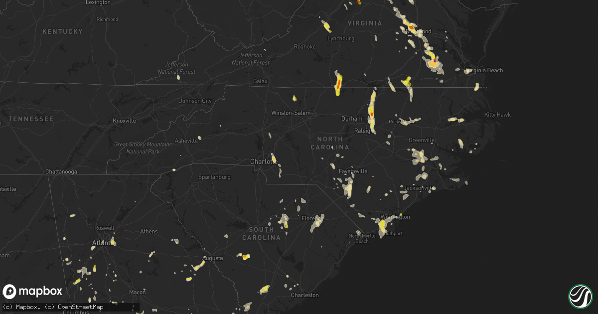
Hail Map in North Carolina on July 19, 2016
Get this storm
July 19 map
$229
one time, instant access
Download today. No call, no setup
Keep the $229
Bought the map and want the full workflow? Apply the entire $229 to a subscription within 7 days. None of it is wasted.
Every map, not just this one
This buys you this map. Subscription and you get every map we run, in the markets you choose from a few cities to whole states to nationwide. Plus real-time alerts the moment a storm fires.
Contact data
Name, contact info, occupancy, even credit band for addresses in the footprint. You go from where it hit to who to call.
Become the source they trust
Unlimited branding weather history reports on demand. You already have the documented answer ready for the property owner, and you are the one who showed up with it.
Property data and RoofTrace estimates
Pull up any address you have got, its value and the exact code rules for that jurisdiction, straight from One Click Code. Then RoofTrace estimates the squares, pitch, and roof value, priced the way you price.
Storm reports in North Carolina
North Carolina
| Date | Description |
|---|---|
| 07/19/20166:44 PM CDT | Thunderstorm winds downed two trees along country club road. |
| 07/19/20166:15 PM CDT | Several small trees down on fruit ridge road south of highway 74 business |
| 07/19/20166:12 PM CDT | Several large oak trees down in the central part of the city. |
| 07/19/20165:48 PM CDT | Thunderstorm winds resulted in numerous trees down within the community of walnut cove. |
| 07/19/20165:44 PM CDT | Thunderstorm winds resulted in at least two trees down temporarily cloising roads between danbury and germanton nc. |
| 07/19/20165:40 PM CDT | One tree down on rocky ridge sims road near luther road. |
| 07/19/20165:35 PM CDT | Thunderstorm winds resulted in several trees down within the community of meadows in stokes county... Nc. |
| 07/19/20165:35 PM CDT | Thunderstorm winds resulted in at least two trees down temporarily cloising roads between danbury and germanton nc. |
| 07/19/20164:52 PM CDT | 2 trees down off midway road between boat lane and zachary path |
| 07/19/20164:35 PM CDT | Onslow county 911 reported a tree down across piney green road. Time based on radar. |
| 07/19/20164:15 PM CDT | Trees and power lines down on mill creek road near the intersection with graphite road. Time determined from radar data. |
| 07/19/20163:35 PM CDT | Several trees down on cottonwood lane |
| 07/19/20163:01 PM CDT | Tree down across the road at the intersection of wintergreen and loop rd. In cove city. |
| 07/19/20162:49 PM CDT | Public reported dime to quarter size hail near quinerly crossroads east of grifton. |
| 07/19/20161:12 PM CDT | Intersection of gordon rd and market st. |
| 07/19/201612:30 PM CDT | Tree down on adams creek rd. In havelock |
| 07/19/201611:12 AM CDT | A couple trees blown down on lanier ln. |
| 07/19/201611:10 AM CDT | Trees blown down and blocking morgan mill rd near deese rd. |
| 07/19/201611:04 AM CDT | Spotter reports tree on vehicle at rosemont ave and south main st. |
| 07/19/201610:50 AM CDT | A local report indicates 59 MPH wind near NEW RIVER |
| 07/19/20167:46 AM CDT | Report of tree down in ponzer area |
| 07/18/201611:12 PM CDT | A couple trees blown down on lanier ln. |
| 07/18/201611:10 PM CDT | Trees blown down and blocking morgan mill rd near deese rd. |
| 07/18/201611:06 PM CDT | Tree blown down over snatchburg rd. Time radar estimated. |
| 07/18/201611:05 PM CDT | Hoke county office of ncdot reports that several fallen trees had to be cleared from county roadways. |
| 07/18/201611:04 PM CDT | Spotter reports tree on vehicle at rosemont ave and south main st. |
| 07/18/201611:03 PM CDT | A tree was blown down on a power line which began to arc. |
| 07/18/201610:45 PM CDT | Trees and powerlines down along rankin street. |
| 07/18/201610:44 PM CDT | Section of siding was blown off house. Penny size hail. |
| 07/18/201610:42 PM CDT | Spotter reports trees blown down blocking roadway at mt olivet rd and cemetary st. |
| 07/18/201610:09 PM CDT | Fire dept reports three trees and power lines blown down on pharr mill rd. |
| 07/18/201610:08 PM CDT | Multiple reports of trees and power lines knocked down along hickory ridge rd and around morrison rd. |
| 07/18/20169:52 PM CDT | Tree blown down blocking rocky river road near lower rocky river rd. |
| 07/18/20169:40 PM CDT | Trees down on old knight road. Time approximated by radar. |
| 07/18/20169:35 PM CDT | Tree down. Time estimated by radar. |
| 07/18/20169:01 PM CDT | A tree and powerlines down on a residence. Time estimated by radar. |
| 07/18/20169:00 PM CDT | . |
| 07/18/20168:55 PM CDT | Tree down on powerlines. Time estimated by radar. |
| 07/18/20168:50 PM CDT | Tree down. Time estimated by radar. |
| 07/18/20168:48 PM CDT | Trees knocked down blocking fannie sloan rd near mooresville rd...road closed. Power pole snapped in half. |
| 07/18/20168:48 PM CDT | Trees blown down blocking fannie sloan rd near millbridge rd. Roadway is closed. |
| 07/18/20168:47 PM CDT | Trees blown down across powerlines at the intersection of mooresville rd and round tuit ln. |
| 07/18/20168:47 PM CDT | Power lines knocked down across mooresville rd. Moorseville rd has been closed. |
| 07/18/20168:45 PM CDT | Structural damage on tp rd |
| 07/18/20168:30 PM CDT | Large pine tree down on eastwood terrace. |
| 07/18/20168:12 PM CDT | Several trees down... Some on powerlines. Time estimated by radar. |
| 07/18/20167:20 PM CDT | Tree down on shallowford rd at us 241. |
| 07/18/20167:20 PM CDT | Tree down on scott rd. Radar estimated time. |
All States Impacted by Hail Map on July 19, 2016
Cities Impacted by Hail Map on July 19, 2016
- Jonesborough, TN
- Pinehurst, GA
- Vienna, GA
- Sutherlin, VA
- Ringgold, VA
- Vienna, MD
- Stuarts Draft, VA
- Lyndhurst, VA
- Sterling, CO
- Fleming, CO
- Hawkinsville, GA
- Perry, GA
- Frostproof, FL
- Belhaven, NC
- Scranton, NC
- Moyock, NC
- De Soto, GA
- Leesburg, GA
- Musselshell, MT
- Stapleton, GA
- Blythe, GA
- Wrens, GA
- Matthews, GA
- Dearing, GA
- Augusta, GA
- Centreville, MD
- Goodridge, MN
- Saint Thomas, ND
- Hensel, ND
- Grafton, ND
- Crystal, ND
- Hoople, ND
- Disputanta, VA
- Sac City, IA
- Lytton, IA
- Fall Branch, TN
- Ocheyedan, IA
- Big Sandy, MT
- Zebulon, NC
- Knightdale, NC
- Oxford, NC
- Kittrell, NC
- Wendell, NC
- Wake Forest, NC
- Raleigh, NC
- Youngsville, NC
- Franklinton, NC
- Rolesville, NC
- Henderson, NC
- Lakefield, MN
- Clarks Hill, SC
- Fort Dodge, IA
- Mauk, GA
- Box Springs, GA
- Ivanhoe, NC
- Chinook, MT
- Queenstown, MD
- Allison, IA
- Bishopville, SC
- Willacoochee, GA
- Walhalla, ND
- Atlanta, GA
- Fairburn, GA
- Chevy Chase, MD
- Washington, DC
- Bethesda, MD
- Melville, MT
- Sumter, SC
- Dalzell, SC
- Union, OR
- Roundup, MT
- Portsmouth, IA
- Kershaw, SC
- Bethune, SC
- Cunningham, TN
- Telford, TN
- Bemidji, MN
- Eufaula, AL
- Duffield, VA
- Midland, NC
- Harrisburg, NC
- Concord, NC
- Charlotte, NC
- Stanley, ND
- Minto, ND
- Alvarado, MN
- Warren, MN
- Oslo, MN
- East Grand Forks, MN
- Bowie, MD
- Laurel, MD
- Beltsville, MD
- Adel, GA
- Estherville, IA
- Norway, SC
- Neeses, SC
- Springfield, SC
- Pine Lake, GA
- Decatur, GA
- Lithonia, GA
- Stone Mountain, GA
- Roper, NC
- Shevlin, MN
- Rochelle, VA
- Pratts, VA
- Madison, VA
- Aroda, VA
- Greentop, MO
- Queen City, MO
- Wataga, IL
- New Athens, IL
- Rhoadesville, VA
- Locust Grove, VA
- Spotsylvania, VA
- Supply, NC
- Richmond, VA
- Henrico, VA
- Boulder, CO
- Puposky, MN
- Westside, IA
- Vail, IA
- Jennings, FL
- Woodlawn, TN
- Franklin, VA
- Hyattsville, MD
- Brentwood, MD
- Riverdale, MD
- Fort Benning, GA
- Oglethorpe, GA
- Andersonville, GA
- Ideal, GA
- Russellville, TN
- Morristown, TN
- Maple Hill, NC
- Cove City, NC
- Swanquarter, NC
- Florence, SC
- Effingham, SC
- Edinburg, ND
- Walnut Cove, NC
- Sheffield, IA
- Hampton, IA
- Annapolis, MD
- Edgewater, MD
- Stevensville, MD
- Abingdon, IL
- Cando, ND
- Leeds, ND
- Gallatin, MO
- Hogansville, GA
- Pollocksville, NC
- Maysville, NC
- Fort Stewart, GA
- Hartsville, SC
- Society Hill, SC
- Patrick, SC
- Fort Bragg, NC
- Southern Pines, NC
- Jameson, MO
- Jamesport, MO
- Ruffin, SC
- Walterboro, SC
- Gainesboro, TN
- Roopville, GA
- Red Springs, NC
- Lumber Bridge, NC
- Shannon, NC
- Madison, FL
- Pearson, GA
- Axson, GA
- Shawmut, MT
- Kingston, MO
- Hamilton, MO
- Dover, NC
- Grifton, NC
- Ayden, NC
- Lancaster, MO
- Glenwood, MO
- Portsmouth, VA
- Bolivia, NC
- Bolton, NC
- Southport, NC
- Wilmington, NC
- Oak Island, NC
- Winnabow, NC
- Leland, NC
- Ash, NC
- Hopewell, VA
- Geyser, MT
- Prole, IA
- Saint Charles, IA
- Saint Pauls, NC
- Kinston, NC
- Tarboro, NC
- Lucas, IA
- Valdosta, GA
- Gonvick, MN
- Culpeper, VA
- Mitchells, VA
- Boston, VA
- Broadview, MT
- Rehoboth Beach, DE
- Oxon Hill, MD
- Fort Myer, VA
- Glen Echo, MD
- Arlington, VA
- Clinton, MD
- Naval Anacost Annex, DC
- Suitland, MD
- Temple Hills, MD
- Andrews Air Force Base, MD
- Cabin John, MD
- Van Meter, IA
- Brightwood, VA
- Etlan, VA
- Banco, VA
- Haywood, VA
- Reva, VA
- Syria, VA
- Lumberton, NC
- Senoia, GA
- Long Creek, OR
- Monument, OR
- Sciota, IL
- Blandinsville, IL
- Macomb, IL
- Shellman, GA
- Center, MO
- Woodbury, TN
- Readyville, TN
- Barnesville, GA
- Milner, GA
- East Saint Louis, IL
- Belleville, IL
- Buchanan, GA
- Maxton, NC
- Pembroke, NC
- Chambersburg, IL
- Griggsville, IL
- Elkton, VA
- Stanley, VA
- Celina, TN
- Whitleyville, TN
- Hilham, TN
- Norfolk, VA
- Ewing, MO
- Melrose, IA
- Russell, IA
- Chariton, IA
- Lovilia, IA
- Pineland, SC
- Delta, AL
- Lineville, AL
- Brayton, IA
- Exira, IA
- Varnville, SC
- Indianola, IA
- Lacona, IA
- Milo, IA
- Liberty Center, IA
- Montrose, GA
- Cochran, GA
- Chester, GA
- Danville, GA
- Windsor, NC
- Merry Hill, NC
- Westphalia, IA
- Harlan, IA
- Kirkman, IA
- Earling, IA
- Lewes, DE
- Millsboro, DE
- Bethany Beach, DE
- Wallowa, OR
- Petersburg, VA
- Chesterfield, VA
- Williamson, IA
- Chauncey, GA
- Nemaha, IA
- Newell, IA
- Fonda, IA
- Suffolk, VA
- Kingsport, TN
- Kenly, NC
- Lucama, NC
- Stites, ID
- Elko, GA
- Browning, IL
- Astoria, IL
- Braymer, MO
- Clear Lake, IA
- Thornton, IA
- Leonard, MN
- Redlake, MN
- Louisville, GA
- Waverly, VA
- Spring Grove, VA
- Falls Church, VA
- Rockwell City, IA
- Lake City, IA
- Spencer, IA
- Dickens, IA
- West Blocton, AL
- Langdon, ND
- Schaller, IA
- Galva, IA
- Cumming, IA
- Norwalk, IA
- Old Fort, NC
- Black Mountain, NC
- Abbeville, AL
- Gilmore City, IA
- Palmer, IA
- Pocahontas, IA
- Somers, IA
- Midlothian, VA
- Peshastin, WA
- Unionville, VA
- Mohawk, TN
- Bybee, TN
- Jackson, MN
- Rocky Mount, NC
- Imnaha, OR
- Headland, AL
- Newville, AL
- Washington, NC
- Moreland, GA
- Luthersville, GA
- Grantville, GA
- Greenville, GA
- Newnan, GA
- Gay, GA
- Salisbury, MD
- Dixie, GA
- Quitman, GA
- Pamplico, SC
- Pembroke, GA
- Weldon, IA
- Carlyle, IL
- Sandoval, IL
- Powhatan, VA
- Minnewaukan, ND
- Churchs Ferry, ND
- Devils Lake, ND
- Penn, ND
- Glasgow, VA
- Buena Vista, VA
- Natural Bridge, VA
- Monroe, VA
- Big Island, VA
- Bedford, VA
- Natural Bridge Station, VA
- Morganton, NC
- Otis, CO
- Akron, CO
- Harrington, DE
- Felton, DE
- Red Lake Falls, MN
- Manakin Sabot, VA
- Rockville, VA
- Chesapeake, VA
- Enterprise, OR
- Booneville, AR
- Winkelman, AZ
- Lagrange, GA
- Grand Forks, ND
- Battle Creek, IA
- Holstein, IA
- Coatsville, MO
- Bloomfield, IA
- Moulton, IA
- Bullock, NC
- Clayton, NC
- Claxton, GA
- Manvel, ND
- Blackduck, MN
- Swansboro, NC
- South Boston, VA
- Alton, VA
- Keeling, VA
- Glen Allen, VA
- Georgetown, DE
- Alexandria, VA
- Fort Washington, MD
- Santa Fe, MO
- Paris, MO
- Thompson, MO
- Woodland, GA
- Talbotton, GA
- Stanford, MT
- Blackville, SC
- Mineral, VA
- Chestertown, MD
- Ida Grove, IA
- Wilsons, VA
- Cottonwood, ID
- Catherine, AL
- Lake Wales, FL
- Partlow, VA
- Ruther Glen, VA
- Wakefield, VA
- Ivor, VA
- Marion, SC
- Englewood, CO
- Lake View, IA
- Bath, IL
- Tenstrike, MN
- Vanceboro, NC
- Hookerton, NC
- Trenton, NC
- Brevard, NC
- Rosman, NC
- Sunset, SC
- Greenfield, TN
- Hampton, GA
- Griffin, GA
- Pearisburg, VA
- Leary, GA
- Godfrey, IL
- Dow, IL
- Buckhead, GA
- Milton, NC
- Chatham, VA
- Vernon Hill, VA
- Yanceyville, NC
- Leasburg, NC
- Java, VA
- Semora, NC
- Blanch, NC
- Massena, IA
- Coffee Creek, MT
- Geraldine, MT
- Ruthven, IA
- Lugoff, SC
- Cadwell, GA
- Sperryville, VA
- Myrtle Beach, SC
- Novelty, MO
- Rock Hall, MD
- Gunpowder, MD
- Butler, AL
- Clearbrook, MN
- Crozet, VA
- Mount Ulla, NC
- Cleveland, NC
- Lamar, SC
- Deer Lodge, TN
- Hobgood, NC
- Battleboro, NC
- Whitakers, NC
- Winnett, MT
- Oilville, VA
- Greenville, IL
- Thomasville, AL
- Knoxville, IA
- Crozier, VA
- Versailles, IL
- Mount Sterling, IL
- Odum, GA
- Garland, NC
- Elizabethtown, NC
- Raeford, NC
- Woodburn, IA
- Thomaston, GA
- Hahira, GA
- Latimer, IA
- Coulter, IA
- Longs, SC
- Kevil, KY
- La Center, KY
- Prince George, VA
- Nashville, GA
- Waynesboro, VA
- Crimora, VA
- Sharpsburg, GA
- Perry, FL
- Roseville, IL
- Good Hope, IL
- Pennington, MN
- Dumont, IA
- Lostine, OR
- Black Hawk, CO
- Molt, MT
- Whiteville, NC
- Shelbyville, MO
- Garysburg, NC
- Bowdon, GA
- Franklin, GA
- Brodnax, VA
- La Crosse, VA
- South Hill, VA
- Monroe City, MO
- Naylor, GA
- Watertown, TN
- Alexandria, TN
- Maidens, VA
- Bumpass, VA
- Montpelier, VA
- Pine, CO
- Bailey, CO
- Conifer, CO
- Milford, IA
- Dawson, GA
- Rembert, SC
- Polk City, FL
- Lakeland, FL
- Laurel, DE
- Seaford, DE
- Rhodesdale, MD
- Bethel, DE
- Bogard, MO
- Potomac, MD
- Gaithersburg, MD
- Pell City, AL
- Washington, GA
- Fisher, MN
- Drayton, ND
- Cavalier, ND
- Grovetown, GA
- Hebron, MD
- Eolia, MO
- Thompson Falls, MT
- Surry, VA
- Bluffs, IL
- Butler, GA
- Fort Campbell, KY
- West Green, GA
- Herndon, KY
- Hopkinsville, KY
- Oak Grove, KY
- White Bird, ID
- Grangeville, ID
- Waterloo, IL
- Red Bud, IL
- Hecker, IL
- Windsor, VA
- Smithfield, VA
- Ridgeville, SC
- Sedley, VA
- Sanford, NC
- Hines, MN
- Grottoes, VA
- Americus, GA
- Graettinger, IA
- Jolley, IA
- Emporia, VA
- New London, MO
- Osceola, IA
- Saint Marys, IA
- Martensdale, IA
- New Virginia, IA
- Edina, MO
- Erwin, TN
- Louisa, VA
- Smithville, GA
- Leslie, GA
- Rapidan, VA
- Morgan, GA
- Belknap, IL
- Cypress, IL
- Cumberland Furnace, TN
- Islandton, SC
- House Springs, MO
- Wedowee, AL
- Pleasant Hill, NC
- Weldon, NC
- Gaston, NC
- Halifax, NC
- Havelock, NC
- Gate City, VA
- Leon, VA
- Oracle, AZ
- Bronwood, GA
- Stella, NC
- Lawrenceville, VA
- Warner Robins, GA
- New Bern, NC
- Brandywine, MD
- Huntingtown, MD
- Owings, MD
- Aquasco, MD
- Upper Marlboro, MD
- Alpha, MN
- West Point, VA
- Clayton, AL
- Fayetteville, NC
- Exline, IA
- Unionville, MO
- Pikeville, NC
- Fremont, NC
- Carrollton, MO
- Sims, NC
- Wilson, NC
- Creston, IA
- Climax, MN
- Waverly Hall, GA
- Greensboro, GA
- Udell, IA
- Centerville, IA
- Winchester, IL
- Cumberland, VA
- Farmville, VA
- Dillwyn, VA
- Reynolds, GA
- Milford, DE
- Nesmith, SC
- Woodbury, GA
- Renwick, IA
- Luray, VA
- Mount Vernon, GA
- Kilbourne, IL
- Easton, IL
- Vienna, IL
- Karnak, IL
- Ullin, IL
- Dongola, IL
- Galesburg, IL
- Bealeton, VA
- Warrenton, VA
- Jeffersonton, VA
- Remington, VA
- Rixeyville, VA
- Kila, MT
- Parkton, NC
- Gibson, GA
- Warrenton, GA
- Derby, IA
- Woodford, VA
- Meservey, IA
- Goodell, IA
- Tignall, GA
- Summerville, SC
- Ravenel, SC
- Pilot Rock, OR
- Soperton, GA
- Cuthbert, GA
- Knox City, MO
- Briceville, TN
- Georgetown, GA
- Gum Spring, VA
- McLean, VA
- Rockville, MD
- Cheltenham, MD
- Newington, GA
- Equality, AL
- Reynolds, ND
- Thompson, ND
- Patoka, IL
- Louisville, AL
- Macon, NC
- Ebony, VA
- Littleton, NC
- Bracey, VA
- Chester, MD
- Breda, IA
- Farnhamville, IA
- Gowrie, IA
- Paton, IA
- Churdan, IA
- Cullman, AL
- Vinemont, AL
- Barnardsville, NC
- Albany, GA
- Vass, NC
- Corwith, IA
- Philadelphia, MO
- Durham, MO
- Pleasantville, IA
- Barney, GA
- Tarrytown, GA
- Livonia, MO
- Cragford, AL
- Davidsonville, MD
- Harwood, MD
- Ackworth, IA
- Clarksville, TN
- Bethel, MO
- La Belle, MO
- Memphis, TN
- Prince Frederick, MD
- Marion, AR
- Pearce, AZ
- Columbia, TN
- Rentz, GA
- Dublin, GA
- Walnut, IA
- Garnett, SC
- Clyo, GA
- Tillman, SC
- Ridge Spring, SC
- Ward, SC
- Newport, NC
- Deloit, IA
- Ray City, GA
- Cameron, NC
- Coward, SC
- Scranton, SC
- Greenville, IA
- Royal, IA
- Jefferson, IA
- Ladson, SC
- Adrian, GA
- Swainsboro, GA
- Lakeland, GA
- Harcourt, IA
- Harbeson, DE
- Frankford, DE
- Ocean View, DE
- Fitzgerald, GA
- Kingston, GA
- Rome, GA
- Monticello, GA
- Mexico, MO
- Rutledge, MO
- Bradford, TN
- Cass Lake, MN
- Salley, SC
- Humeston, IA
- Garden Grove, IA
- Gracey, KY
- Unadilla, GA
- Ludlow, MO
- Norborne, MO
- Lignum, VA
- Beaverdam, VA
- Burr Hill, VA
- Jacksonville, NC
- Camden, SC
- Spirit Lake, IA
- Hurlock, MD
- Federalsburg, MD
- Bonaire, GA
- Kathleen, GA
- Bon Aqua, TN
- Lyles, TN
- Cincinnati, IA
- Fairfield, NC
- Melcher Dallas, IA
- Lula, GA
- Fenton, IA
- Lone Rock, IA
- Silver Spring, MD
- El Paso, TX
- Grand Junction, IA
- Dana, IA
- Chadbourn, NC
- Evergreen, NC
- Shelbina, MO
- Stony Creek, VA
- Carrsville, VA
- Courtland, VA
- Zuni, VA
- Carson, VA
- Perry, MO
- Cordele, GA
- Tallassee, AL
- Tuskegee, AL
- Shorter, AL
- Snow Hill, NC
- Jakin, GA
- Murray, KY
- Union Grove, AL
- Albert City, IA
- Pinetta, FL
- Eastman, GA
- Sioux Rapids, IA
- Bowling Green, MO
- Hope Mills, NC
- Clarksville, VA
- Alapaha, GA
- Ambrose, GA
- Douglas, GA
- Pine Mountain, GA
- Sutherland, IA
- Peterson, IA
- Denver, CO
- Littleton, CO
- Big Timber, MT
- Columbus, MT
- Toano, VA
- Orondo, WA
- Lomax, IL
- Raritan, IL
- Atlantic, IA
- Tiplersville, MS
- Sandston, VA
- Chester, VA
- Charles City, VA
- Ludowici, GA
- Glennville, GA
- Hartley, IA
- Osnabrock, ND
- Baylis, IL
- La Grande, OR
- Willard, NC
- Cassatt, SC
- Forest City, IA
- Norcross, GA
- Lilburn, GA
- Columbia, SC
- Anita, IA
- Fowler, IL
- Paloma, IL
- Quincy, IL
- Lohrville, IA
- Altoona, AL
- Boaz, AL
- Batesburg, SC
- Cascilla, MS
- Morris, GA
- Palmyra, MO
- Rayle, GA
- Virginia Beach, VA
- Rolfe, IA
- Zebulon, GA
- Richlands, NC
- Charlotte, TN
- Dickson, TN
- Lewistown, IL
- Register, GA
- Macedonia, IL
- Thompsonville, IL
- Bancroft, IA
- Swea City, IA
- Goldfield, IA
- Greeneville, TN
- Concord, IL
- Chapin, IL
- Milan, GA
- Pisgah Forest, NC
- Stoutsville, MO
- Jacksonville, IL
- Monroe, NC
- Lexington, VA
- Rutland, IA
- Bode, IA
- Humboldt, IA
- Buena Vista, GA
- Euclid, MN
- Argyle, MN
- Mountain, ND
- Spickard, MO
- Beaufort, NC
- Trenton, TN
- Red Oak, VA
- Nashville, NC
- Guyton, GA
- Brooklet, GA
- Central City, CO
- Bath, NC
- Hunnewell, MO
- Portage Des Sioux, MO
- Lothian, MD
- Dagsboro, DE
- Millville, DE
- Milton, DE
- Oskaloosa, IA
- Nashville, TN
- Church Road, VA
- Ford, VA
- Manchester, GA
- Grimesland, NC
- Chocowinity, NC
- Livermore, IA
- York, ND
- Gordonsville, VA
- Manson, IA
- Ernul, NC
- Garner, IA
- Clare, IA
- Barnum, IA
- Persia, IA
- Lebanon, TN
- Mansfield, WA
- Camp Lejeune, NC
- Lamont, FL
- Vermont, IL
- Ipava, IL
- Ellaville, GA
- Brandy Station, VA
- Wray, GA
- Colchester, IL
- Golden, CO
- Tallapoosa, GA
- Hubert, NC
- Wallace, NC
- Mount Rainier, MD
- Takoma Park, MD
- Capitol Heights, MD
- Kensington, MD
- District Heights, MD
- College Park, MD
- Bladensburg, MD
- Dunkirk, MD
- Neola, IA
- Roberta, GA
- Salem, FL
- Steinhatchee, FL
- Lavina, MT
- Mitchell, GA
- Sealevel, NC
- Crawfordville, FL
- Skippers, VA
- Elk Horn, IA
- Saint Regis, MT
- Ryegate, MT
- Grantsboro, NC
- Union Springs, AL
- Eatonton, GA
- Amelia Court House, VA
- Sparta, IL
- Castleton, VA
- Shelby, IA
- Panama, IA
- Audubon, IA
- Kimballton, IA
- Avoca, IA
- Rembrandt, IA
- Roseboro, NC
- Clinton, NC
- West End, NC
- Windsor, SC
- Williston, SC
- Alexander, IA
- Shorterville, AL
- Loris, SC
- Charleston, AR
- Pomeroy, IA
- Glidden, IA
- Roanoke Rapids, NC
- Kidder, MO
- Odin, IL
- Holiday, FL
- New Port Richey, FL
- Geneva, IA
- Wingate, NC
- Broxton, GA
- Shenandoah, VA
- Macon, GA
- Bladenboro, NC
- Downing, MO
- Britt, IA
- Correctionville, IA
- Cushing, IA
- Oneonta, AL
- Taylor, MO
- Bussey, IA
- Ashville, AL
- Steele, AL
- Ashland, AL
- Greenwood, VA
- Afton, VA
- Charlottesville, VA
- Oberon, ND
- Prairie City, OR
- Whitesburg, TN


