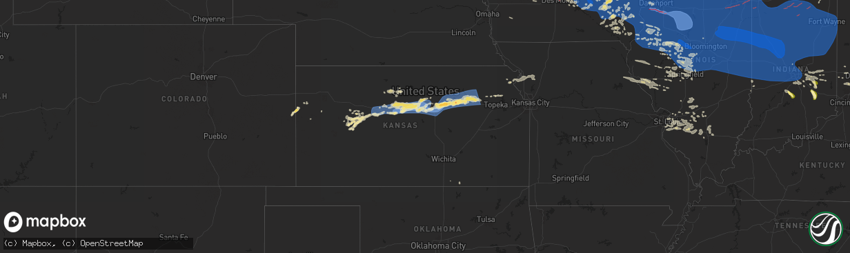
Hail Map in Kansas on July 15, 2024
The weather event in Kansas on July 15, 2024 includes Hail, Wind, and Tornado maps. 29 states and 2,623 cities were impacted and suffered possible damage. The total estimated number of properties impacted is 0.
Want more than just the map?
Turn this storm into a full workflow.
- Owner + property data so you know who to knock
- OnDemand branded weather history reports to win the "did we even have hail?" argument
- RoofTrace estimate so reps stop guessing numbers at the door
Bought this map? Upgrade within 7 days and we'll credit the $230. (10-15 min setup call)
Hail
Wind
Tornado
0
Estimated number of impacted properties by a 1.00" hail or larger0
Estimated number of impacted properties by a 1.75" hail or larger0
Estimated number of impacted properties by a 2.50" hail or largerStorm reports in Kansas
Kansas
| Date | Description |
|---|---|
| 07/15/20246:50 AM CDT | Power is out across the town. |
| 07/15/20246:36 AM CDT | 60-70 mph wind gusts. |
| 07/15/20246:15 AM CDT | 60-70 mph wind gusts. |
| 07/15/20246:15 AM CDT | A local report indicates 70 MPH wind near 6 NNE Chapman |
| 07/15/20246:14 AM CDT | Estimated gusts of 65-70 mph. |
| 07/15/20246:08 AM CDT | A local report indicates 60 MPH wind near 5 SSE Milford |
| 07/15/20245:59 AM CDT | Delayed report. Tree down on third street in clay center. Time estimated from radar. |
| 07/15/20245:58 AM CDT | Trained spotter estimating 60-70 mph wind gusts. Time estimated from radar. |
| 07/15/20245:36 AM CDT | 6 inch tree limb down in longford. Time estimated from radar. |
| 07/15/20245:17 AM CDT | Measured by a home weather station. |
| 07/15/20245:14 AM CDT | Picture came in of a tree around a foot in diameter snapped in minneapolis. |
| 07/15/20245:01 AM CDT | A local report indicates 58 MPH wind near 2 SW Salina |
| 07/15/20244:33 AM CDT | A local report indicates 80 MPH wind near Lincoln |
| 07/15/20244:28 AM CDT | A local report indicates 70 MPH wind near Lincoln |
| 07/15/20244:20 AM CDT | A local report indicates 67 MPH wind near 7 SW Sylvan Grove |
| 07/15/20244:08 AM CDT | A local report indicates 93 MPH wind near 3 NNE Bunker Hill |
| 07/15/20244:08 AM CDT | Power lines down and power poles snapped in russell. Time estimated on radar. |
| 07/15/20244:08 AM CDT | Power poles snapped. Time based on radar. |
| 07/15/20244:08 AM CDT | Two campers rolled over. Time based on radar. |
| 07/15/20243:54 AM CDT | A local report indicates 85 MPH wind near Russell Airport |
| 07/15/20243:46 AM CDT | A local report indicates 76 MPH wind near Russell Airport |
| 07/15/20243:41 AM CDT | Corrects previous tstm wnd gst report from 1 ne russell airport. |
| 07/15/20243:40 AM CDT | A local report indicates 65 MPH wind near 5 NNE Gorham |
| 07/15/20243:39 AM CDT | A local report indicates 62 MPH wind near 4 W Russell |
| 07/15/20243:23 AM CDT | Mesonet station up853 walker |
| 07/15/20243:22 AM CDT | 2-foot diameter trees down in town. Time estimated from radar. |
| 07/15/20243:15 AM CDT | Awos station khys hays regional airport awos site. |
| 07/15/20242:56 AM CDT | Awos station khys hays regional airport awos site. |
| 07/15/20242:36 AM CDT | A local report indicates 68 MPH wind near 1 ESE Riga |
| 07/15/20242:26 AM CDT | A local report indicates 88 MPH wind near 3 SW Cedar Bluff |
| 07/15/20242:08 AM CDT | A local report indicates 72 MPH wind near Ransom |
All States Impacted by Hail Map on July 15, 2024
Cities Impacted by Hail Map on July 15, 2024
- Murdock, MN
- Montevideo, MN
- Maynard, MN
- Kerkhoven, MN
- Springfield, MN
- Raymond, MN
- Clara City, MN
- Sleepy Eye, MN
- Comfrey, MN
- Morgan, MN
- Canistota, SD
- Prinsburg, MN
- Willmar, MN
- Lake Lillian, MN
- Renville, MN
- Blomkest, MN
- Montrose, SD
- Saint James, MN
- Danube, MN
- Olivia, MN
- Bird Island, MN
- Hector, MN
- Fairfax, MN
- Lewisville, MN
- Truman, MN
- Winnebago, MN
- Westfield, NY
- Ripley, NY
- Portland, NY
- Fredonia, NY
- Brocton, NY
- Mantee, MS
- Woodland, MS
- Buffalo, NY
- Grand Island, NY
- Tonawanda, NY
- East Amherst, NY
- Clarence, NY
- Clarence Center, NY
- Gilbertown, AL
- Pheba, MS
- Cedarbluff, MS
- Eupora, MS
- Gainesville, FL
- Ackerman, MS
- Society Hill, SC
- Cheraw, SC
- West Warren, MA
- Ware, MA
- Palmer, MA
- Warren, MA
- Silver Creek, NY
- Jesup, GA
- Greenfield, IN
- Angola, NY
- Eden, NY
- Hamburg, NY
- Arlington, IN
- Carthage, IN
- Columbus, MS
- Starkville, MS
- Arcanum, OH
- Citra, FL
- Buena Vista, GA
- Hazlehurst, GA
- New Palestine, IN
- Fountaintown, IN
- Lake City, FL
- Belchertown, MA
- Granby, MA
- Ludlow, MA
- Gowanda, NY
- Collins, NY
- Morristown, IN
- West Falls, NY
- East Aurora, NY
- Orchard Park, NY
- Boston, NY
- Colden, NY
- Riceboro, GA
- Cassadaga, NY
- Somerville, OH
- Hamilton, OH
- Rushville, IN
- Louisville, MS
- Elma, NY
- Alden, NY
- Lancaster, NY
- Depew, NY
- Reynolds, GA
- Fort Valley, GA
- Darien, GA
- Townsend, GA
- Ocala, FL
- Anthony, FL
- South Wales, NY
- Saint Matthews, SC
- Middletown, OH
- Brunswick, GA
- Dayton, OH
- Napoleonville, LA
- Trenton, OH
- Attica, NY
- Warsaw, NY
- Dale, NY
- Wyoming, NY
- East Bethany, NY
- Reform, AL
- Butler, GA
- Connersville, IN
- Glenwood, IN
- Port Wentworth, GA
- Pooler, GA
- Savannah, GA
- Gwynneville, IN
- Bloomingdale, GA
- Springville, NY
- Valdosta, GA
- Cattaraugus, NY
- Xenia, OH
- Alpha, OH
- Yellow Springs, OH
- Holland, NY
- Green Pond, SC
- Marshville, NC
- Mount Kisco, NY
- Bedford Hills, NY
- Katonah, NY
- Pavilion, NY
- Byron, GA
- Warner Robins, GA
- Centerville, GA
- Clewiston, FL
- Alexander, NY
- Franklin, OH
- Fairborn, OH
- Bellbrook, OH
- Linwood, NY
- Le Roy, NY
- Caledonia, NY
- Spring Valley, OH
- Cedarville, OH
- Springfield, OH
- South Charleston, OH
- Bedford, NY
- Eaton, OH
- Cuthbert, GA
- Kiron, IA
- Ida Grove, IA
- Bowman, SC
- Cameron, SC
- Schleswig, IA
- South Solon, OH
- Geneseo, NY
- Avon, NY
- Rush, NY
- Honeoye Falls, NY
- Lima, NY
- Bloomfield, NY
- Canandaigua, NY
- West Bloomfield, NY
- Ionia, NY
- Victor, NY
- Saint Augustine, FL
- Livonia, NY
- Lakeville, NY
- Americus, GA
- Odebolt, IA
- Deloit, IA
- Denison, IA
- Kingman, AZ
- New Iberia, LA
- Loreauville, LA
- Dows, IA
- Ridgeland, SC
- Pineland, SC
- Knightstown, IN
- Shelbyville, IN
- Yemassee, SC
- Early Branch, SC
- Brookville, OH
- Lewisburg, OH
- West Alexandria, OH
- Tillman, SC
- Wilberforce, OH
- Farmington, NY
- Shortsville, NY
- Palmyra, NY
- London, OH
- Mount Sterling, OH
- Lehigh, IA
- Vail, IA
- Westside, IA
- Traer, IA
- Stamford, CT
- Coosawhatchie, SC
- Loris, SC
- Lewisville, IN
- Falmouth, IN
- Reinbeck, IA
- Buckingham, IA
- Franklin, GA
- Saint Martinville, LA
- Spiceland, IN
- Shirley, IN
- Charlottesville, IN
- Jeffersonville, OH
- Macedon, NY
- Manchester, NY
- Clifton Springs, NY
- Fort Washakie, WY
- Lander, WY
- Arapahoe, WY
- Riverton, WY
- Hudson, WY
- Darien, CT
- Grove City, OH
- Orient, OH
- Plains, GA
- Lumpkin, GA
- New Castle, IN
- Alden, IA
- Arcadia, IA
- Nevada, IA
- Miamisburg, OH
- Atlanta, GA
- Decatur, GA
- Stratford, IA
- Manning, IA
- Manilla, IA
- La Porte City, IA
- Dysart, IA
- Arthur, IA
- Lagrange, GA
- Lumberton, NC
- Aplington, IA
- Parkersburg, IA
- Westminster, CO
- Broomfield, CO
- Templeton, IA
- Clyo, GA
- Jacksonville, GA
- Milan, GA
- Roanoke, AL
- Duluth, GA
- Hemingway, SC
- Nesmith, SC
- Lake City, SC
- Breaux Bridge, LA
- Conway, SC
- Callender, IA
- Forkland, AL
- Greensboro, AL
- Gallion, AL
- Garnett, SC
- Milton, IN
- Galloway, OH
- West Jefferson, OH
- Stanley, NY
- Newark, NY
- Phelps, NY
- Geneva, NY
- Waterloo, NY
- Seneca Falls, NY
- Lyons, NY
- Clyde, NY
- Cuba, AL
- Gowrie, IA
- Somers, IA
- Pataskala, OH
- Etna, OH
- Toomsuba, MS
- New Hartford, IA
- Shell Rock, IA
- Allison, IA
- Webster City, IA
- Wall Lake, IA
- Audubon, IA
- Dedham, IA
- Breda, IA
- Carroll, IA
- Iowa Falls, IA
- Lafayette, LA
- Kingstree, SC
- Bladenboro, NC
- Duncombe, IA
- New Windsor, MD
- Westminster, MD
- Tar Heel, NC
- Straughn, IN
- Andrews, SC
- Hudson, IA
- Mount Auburn, IA
- Fort Dodge, IA
- Steamboat Rock, IA
- Stanhope, IA
- Coon Rapids, IA
- Bayard, IA
- Jeffrey City, WY
- Milroy, IN
- Trout Creek, MI
- Iron River, MI
- Dayton, IA
- Millersport, OH
- Kirkersville, OH
- Hebron, OH
- Broussard, LA
- Eldora, IA
- Finksburg, MD
- Hampstead, MD
- Flagstaff, AZ
- Clifton, AZ
- San Carlos, AZ
- Rhine, GA
- Adrian, GA
- Garrison, IA
- Vinton, IA
- Watton, MI
- Upperco, MD
- Daggett, MI
- Vulcan, MI
- White Oak, NC
- Hogansville, GA
- Jesup, IA
- Lake, MS
- Forest, MS
- Columbus, OH
- Hilliard, OH
- Savannah, NY
- Cayuga, NY
- Montezuma, NY
- Port Byron, NY
- Red Creek, NY
- Cato, NY
- Auburn, NY
- Elbridge, NY
- Weedsport, NY
- Jordan, NY
- Lawrenceville, PA
- Middlebury Center, PA
- Nelson, PA
- Ulysses, PA
- Knoxville, PA
- Westfield, PA
- Corning, NY
- Lindley, NY
- Painted Post, NY
- Addison, NY
- Osceola, PA
- Harrison Valley, PA
- Tioga, PA
- Elkland, PA
- Mansfield, PA
- Sabinsville, PA
- Wellsboro, PA
- Woodhull, NY
- Big Flats, NY
- Pine City, NY
- Horseheads, NY
- Millerton, PA
- Elmira, NY
- Columbia Cross Roads, PA
- Wellsburg, NY
- Gillett, PA
- Breesport, NY
- Pine Valley, NY
- Lowman, NY
- Erin, NY
- Waterloo, IA
- Cedar Falls, IA
- Carney, MI
- Estill, SC
- Iron Mountain, MI
- Eatonton, GA
- Lockbourne, OH
- Crystal Falls, MI
- Grundy Center, IA
- Wellsburg, IA
- Westfield, MA
- Manilla, IN
- Homer, IN
- Fairland, IN
- Prescott, AZ
- Arnaudville, LA
- Arlington, GA
- Hingham, MA
- Midland, OH
- Blanchester, OH
- Lake View, IA
- Wilson, MI
- Stephenson, MI
- Martville, NY
- Baldwinsville, NY
- Fulton, NY
- Hannibal, NY
- Memphis, NY
- Phoenix, NY
- Warners, NY
- Pennellville, NY
- Camillus, NY
- Liverpool, NY
- Cicero, NY
- Syracuse, NY
- Clay, NY
- Chemung, NY
- Spencer, NY
- Ithaca, NY
- Newfield, NY
- Van Etten, NY
- Cayuta, NY
- Brooktondale, NY
- Willseyville, NY
- Lockwood, NY
- Bark River, MI
- Pilot Mound, IA
- Yarnell, AZ
- Martinsville, IN
- Cohasset, MA
- Hull, MA
- Marenisco, MI
- Bergland, MI
- Mooresboro, NC
- Heath, OH
- Glenford, OH
- Thornville, OH
- Weymouth, MA
- East Weymouth, MA
- Aiken, SC
- Ashburn, GA
- Paton, IA
- Boxholm, IA
- Ogden, IA
- Walker, LA
- Denham Springs, LA
- Gilbertville, IA
- Owego, NY
- Barton, NY
- Waverly, NY
- Sayre, PA
- Candor, NY
- Independence, IA
- Brandon, IA
- Jersey Shore, PA
- Williamsport, PA
- Montgomery, PA
- Linden, PA
- Trout Run, PA
- Cogan Station, PA
- Montoursville, PA
- Hughesville, PA
- Muncy, PA
- Forksville, PA
- New Albany, PA
- Hillsgrove, PA
- Muncy Valley, PA
- Shunk, PA
- Eagles Mere, PA
- Dushore, PA
- Canton, PA
- Laporte, PA
- Unityville, PA
- Lairdsville, PA
- Rowley, IA
- Walker, IA
- Urbana, IA
- Center Point, IA
- Morgantown, IN
- Nashville, IN
- Ewen, MI
- Canal Winchester, OH
- Groveport, OH
- Ashville, OH
- Monticello, GA
- Colo, IA
- State Center, IA
- Towanda, PA
- Troy, PA
- Ulster, PA
- Dana, IA
- Boone, IA
- Williams, IA
- Harcourt, IA
- Carroll, OH
- Lancaster, OH
- Baltimore, OH
- Pickerington, OH
- Hillsboro, GA
- Thurston, OH
- Pleasantville, OH
- Indianapolis, IN
- Clarksville, OH
- Brewerton, NY
- Central Square, NY
- Constantia, NY
- West Monroe, NY
- Lisle, NY
- Newark Valley, NY
- Richford, NY
- Slaterville Springs, NY
- Berkshire, NY
- Dryden, NY
- Harford, NY
- Freeville, NY
- Marathon, NY
- Cortland, NY
- Homer, NY
- McGraw, NY
- Lopez, PA
- Mildred, PA
- Republic, MI
- Cleveland, NY
- Bernhards Bay, NY
- Williamstown, NY
- Tully, NY
- Truxton, NY
- Cincinnatus, NY
- Willet, NY
- Wyalusing, PA
- Laceyville, PA
- Sugar Run, PA
- Meshoppen, PA
- Tunkhannock, PA
- Mehoopany, PA
- Rome, PA
- Warren Center, PA
- Le Raysville, PA
- Little Meadows, PA
- Lynchburg, OH
- Greensburg, IN
- Ontario, NY
- Walworth, NY
- Radcliffe, IA
- Greenwood, IN
- Waldron, IN
- Palo, IA
- Appling, GA
- Aurora, IA
- Shellsburg, IA
- Hazleton, IA
- Urbandale, IA
- Windsor Heights, IA
- Des Moines, IA
- Parish, NY
- Camden, NY
- De Ruyter, NY
- McDonough, NY
- Pitcher, NY
- South Otselic, NY
- North Pitcher, NY
- Apalachin, NY
- Montrose, PA
- Springville, PA
- Strawberry Point, IA
- Lamont, IA
- Winthrop, IA
- Stanley, IA
- Oelwein, IA
- Fairbank, IA
- Dunkerton, IA
- Dundee, IA
- Fairfax, IA
- Alburnett, IA
- Van Horne, IA
- Newhall, IA
- Robins, IA
- Central City, IA
- Masonville, IA
- Toddville, IA
- Coggon, IA
- Quasqueton, IA
- Hiawatha, IA
- Cedar Rapids, IA
- Swisher, IA
- Marion, IA
- Atkins, IA
- Norway, IA
- Guttenberg, IA
- Dyersville, IA
- Worthington, IA
- Edgewood, IA
- Earlville, IA
- Hopkinton, IA
- Ely, IA
- Prairieburg, IA
- Holy Cross, IA
- Farley, IA
- Colesburg, IA
- Delhi, IA
- New Vienna, IA
- Springville, IA
- Delaware, IA
- Manchester, IA
- Luxemburg, IA
- Ryan, IA
- Monticello, IA
- Greeley, IA
- Anamosa, IA
- Nineveh, IN
- Westdale, NY
- Altmar, NY
- Redfield, NY
- Saint Paul, IN
- Flat Rock, IN
- Panora, IA
- Guthrie Center, IA
- Athens, PA
- Elizabethtown, NC
- Ames, IA
- Wysox, PA
- Milan, PA
- Zanesville, OH
- Hubbard, IA
- Willcox, AZ
- Damascus, GA
- Benton, PA
- Cuba City, WI
- Platteville, WI
- Toledo, IA
- Hillsboro, OH
- Aurora, NY
- Romulus, NY
- Ovid, NY
- Gilbert, IA
- Dike, IA
- Whiteland, IN
- Chelsea, IA
- Gladbrook, IA
- Lincoln, IA
- Elberon, IA
- Vining, IA
- Belle Plaine, IA
- Albany, GA
- Clarksville, IA
- Sherrill, IA
- Langworthy, IA
- Durango, IA
- Potosi, WI
- Martelle, IA
- Cascade, IA
- Dickeyville, WI
- Dubuque, IA
- Mount Vernon, IA
- Peosta, IA
- Epworth, IA
- Garber, IA
- North Buena Vista, IA
- Cassville, WI
- Morley, IA
- Center Junction, IA
- Zwingle, IA
- Olin, IA
- Wyoming, IA
- Mechanicsville, IA
- Onslow, IA
- Bernard, IA
- Hazel Green, WI
- Kieler, WI
- Lisbon, IA
- Solon, IA
- Alcova, WY
- Casper, WY
- Mills, WY
- Evansville, WY
- Erieville, NY
- South Plymouth, NY
- Smyrna, NY
- Georgetown, NY
- Sherburne, NY
- Plymouth, NY
- Hamilton, NY
- Earlville, NY
- Eaton, NY
- New Woodstock, NY
- Bouckville, NY
- Madison, NY
- Hubbardsville, NY
- Morrisville, NY
- Waterville, NY
- Vestal, NY
- Endicott, NY
- Harford, PA
- Kingsley, PA
- Factoryville, PA
- Hop Bottom, PA
- New Milford, PA
- Nicholson, PA
- Madrid, IA
- Kelley, IA
- Slater, IA
- Tama, IA
- Casey, IA
- Newton, GA
- Yale, IA
- Lincoln, AL
- Darlington, WI
- Belmont, WI
- Mineral Point, WI
- Granger, IA
- Woodward, IA
- Lake Park, GA
- Story City, IA
- Naples, NY
- Rushville, NY
- Chandlersville, OH
- Morrison, IA
- Keystone, IA
- Watkins, IA
- Walford, IA
- Glenrock, WY
- West Winfield, NY
- West Edmeston, NY
- Brookfield, NY
- Oriskany Falls, NY
- North Brookfield, NY
- Leonardsville, NY
- Cassville, NY
- Bridgewater, NY
- Sauquoit, NY
- North Liberty, IA
- Tiffin, IA
- Oxford, IA
- Lowville, NY
- Constableville, NY
- Richland, NY
- Lorraine, NY
- Marion, NY
- South Wayne, WI
- Argyle, WI
- Huxley, IA
- Maxwell, IA
- Johnston, IA
- Polk City, IA
- Dallas Center, IA
- Grimes, IA
- Blakely, GA
- Menlo, IA
- Cochise, AZ
- Grand Junction, IA
- Sheldahl, IA
- Clutier, IA
- New Concord, OH
- Pearce, AZ
- Clinton, WI
- Sharon, WI
- Washington, GA
- Kellogg, IA
- Hartwick, IA
- Middle Amana, IA
- Homestead, IA
- Newton, IA
- Malcom, IA
- Williamsburg, IA
- South Amana, IA
- Amana, IA
- Marengo, IA
- Gilman, IA
- Grinnell, IA
- Baxter, IA
- Laurel, IA
- Conroy, IA
- Brooklyn, IA
- Ladora, IA
- Victor, IA
- Mingo, IA
- Ira, IA
- Colfax, IA
- Deep River, IA
- Montezuma, IA
- Prairie City, IA
- Monroe, IA
- Pella, IA
- Guernsey, IA
- Otley, IA
- Lynnville, IA
- Killduff, IA
- Sully, IA
- Searsboro, IA
- Reasnor, IA
- New Sharon, IA
- Blairstown, IA
- Luzerne, IA
- Clarence, IA
- Oxford Junction, IA
- La Motte, IA
- Delmar, IA
- Lost Nation, IA
- Maquoketa, IA
- Andrew, IA
- Bellevue, IA
- Spragueville, IA
- Monmouth, IA
- Baldwin, IA
- East Dubuque, IL
- Benton, WI
- Galena, IL
- Shullsburg, WI
- Preston, IA
- Scales Mound, IL
- Lowden, IA
- Wheatland, IA
- Hanover, IL
- Charlotte, IA
- Stanwood, IA
- Savanna, IL
- Millville, PA
- Sweet Valley, PA
- Shickshinny, PA
- Harveys Lake, PA
- Old Forge, PA
- Duryea, PA
- Pittston, PA
- Dalton, PA
- Kingston, PA
- Taylor, PA
- Moosic, PA
- Hunlock Creek, PA
- Wyoming, PA
- Dallas, PA
- Falls, PA
- Noxen, PA
- Shavertown, PA
- Clarks Summit, PA
- Archbald, PA
- Fleetville, PA
- Lenoxville, PA
- Union Dale, PA
- Scranton, PA
- Jermyn, PA
- Forest City, PA
- Lake Ariel, PA
- Olyphant, PA
- Jessup, PA
- Moscow, PA
- Waymart, PA
- Carbondale, PA
- Waverly, PA
- Honesdale, PA
- Peckville, PA
- Susquehanna, PA
- Hawley, PA
- Prompton, PA
- South Gibson, PA
- Pleasant Mount, PA
- Herrick Center, PA
- Thompson, PA
- Jackson, PA
- Blanchardville, WI
- Monticello, WI
- New Glarus, WI
- Richfield Springs, NY
- Clayville, NY
- Ilion, NY
- Frankfort, NY
- Bondurant, IA
- Shelby, NC
- Lawndale, NC
- Bargersville, IN
- Sierra Vista, AZ
- Hereford, AZ
- Winterville, GA
- Saint David, AZ
- Mitchellville, IA
- Luther, IA
- Ankeny, IA
- Monroe, WI
- Mullins, SC
- Galivants Ferry, SC
- Nichols, SC
- Liscomb, IA
- Union Springs, NY
- Elliott, IA
- Red Oak, IA
- Gibson, IA
- Rose Hill, IA
- Barnes City, IA
- Leighton, IA
- North English, IA
- Webster, IA
- Oskaloosa, IA
- Delta, IA
- Keswick, IA
- Millersburg, IA
- Parnell, IA
- What Cheer, IA
- Hedrick, IA
- South English, IA
- Sigourney, IA
- Harper, IA
- Hayesville, IA
- Hills, IA
- Kalona, IA
- Iowa City, IA
- Washington, IA
- Lone Tree, IA
- Atalissa, IA
- West Branch, IA
- Nichols, IA
- Riverside, IA
- West Liberty, IA
- West Chester, IA
- Wellman, IA
- Ainsworth, IA
- Keota, IA
- Ollie, IA
- Grand Mound, IA
- Calamus, IA
- Coralville, IA
- Moscow, IA
- Wilton, IA
- Tipton, IA
- Bennett, IA
- Stockton, IL
- Miles, IA
- Apple River, IL
- Elizabeth, IL
- Gratiot, WI
- Warren, IL
- Lena, IL
- Nora, IL
- Westport, IN
- Bryant, IA
- Sabula, IA
- Jacksonville, AL
- Young, AZ
- Louisville, GA
- Garland, NC
- Franklin, IN
- Model, CO
- Runnells, IA
- Altoona, IA
- Pleasant Hill, IA
- Copenhagen, NY
- Mohawk, NY
- Herkimer, NY
- Little Falls, NY
- Jordanville, NY
- Friendsville, PA
- Brackney, PA
- Binghamton, NY
- Windsor, NY
- Kirkwood, NY
- Conklin, NY
- Johnson City, NY
- Port Crane, NY
- Harpursville, NY
- Afton, NY
- Ouaquaga, NY
- Packwood, IA
- Richland, IA
- Martinsburg, IA
- Brighton, IA
- Columbus Junction, IA
- Fruitland, IA
- Crawfordsville, IA
- De Witt, IA
- Donahue, IA
- Muscatine, IA
- Welton, IA
- Walcott, IA
- Stockton, IA
- Dixon, IA
- Durant, IA
- New Liberty, IA
- Conesville, IA
- Blue Grass, IA
- Letts, IA
- Wayland, IA
- Illinois City, IL
- Long Grove, IA
- Goose Lake, IA
- Clinton, IA
- Eldridge, IA
- Davenport, IA
- Teeds Grove, IA
- Mount Carroll, IL
- Lanark, IL
- Woodford, WI
- Shannon, IL
- Winslow, IL
- Pearl City, IL
- Browntown, WI
- Kent, IL
- Walton, NY
- Milanville, PA
- Fishs Eddy, NY
- East Branch, NY
- Equinunk, PA
- Starlight, PA
- Damascus, PA
- Preston Park, PA
- Long Eddy, NY
- Hancock, NY
- Lake Como, PA
- Beach Lake, PA
- Tyler Hill, PA
- Lakewood, PA
- Starrucca, PA
- Downsville, NY
- Narrowsburg, NY
- Hankins, NY
- Cochecton, NY
- Lake Huntington, NY
- Hortonville, NY
- Roscoe, NY
- Callicoon, NY
- Fremont Center, NY
- Youngsville, NY
- Ferndale, NY
- Ellenville, NY
- Kiamesha Lake, NY
- North Branch, NY
- Napanoch, NY
- Swan Lake, NY
- South Fallsburg, NY
- Smallwood, NY
- Liberty, NY
- Eldred, NY
- Claryville, NY
- Parksville, NY
- Monticello, NY
- Bethel, NY
- Neversink, NY
- Livingston Manor, NY
- Mongaup Valley, NY
- Loch Sheldrake, NY
- Kenoza Lake, NY
- White Sulphur Springs, NY
- Harris, NY
- White Lake, NY
- Grahamsville, NY
- Woodridge, NY
- Fallsburg, NY
- Jeffersonville, NY
- Hurleyville, NY
- Woodbourne, NY
- Delancey, NY
- Delhi, NY
- Andes, NY
- Hamden, NY
- Arkville, NY
- Bloomville, NY
- Margaretville, NY
- Bovina Center, NY
- Orangeville, IL
- Freeport, IL
- McConnell, IL
- Sidney, NY
- Unadilla, NY
- Mount Upton, NY
- Deposit, NY
- Nineveh, NY
- Bainbridge, NY
- South New Berlin, NY
- Masonville, NY
- Franklin, NY
- Wells Bridge, NY
- Oneonta, NY
- Sidney Center, NY
- Otego, NY
- Wrens, GA
- Bisbee, AZ
- Belleville, WI
- Albany, WI
- Brooklyn, WI
- Knoxville, IA
- Harrells, NC
- Patagonia, AZ
- Swan, IA
- Locke, NY
- Genoa, NY
- Reynolds, IL
- Milan, IL
- Morris, NY
- West Oneonta, NY
- Laurens, NY
- Maryland, NY
- Mediapolis, IA
- Columbus City, IA
- Grandview, IA
- Mount Pleasant, IA
- Winfield, IA
- Wapello, IA
- New Boston, IL
- Morning Sun, IA
- Olds, IA
- Sperry, IA
- Mount Union, IA
- Yarmouth, IA
- Keithsburg, IL
- Oakville, IA
- Aledo, IL
- Seaton, IL
- Joy, IL
- Andalusia, IL
- Buffalo, IA
- Taylor Ridge, IL
- Rock Island, IL
- Montpelier, IA
- Sherrard, IL
- South Kortright, NY
- Halcottsville, NY
- Roxbury, NY
- New Kingston, NY
- Fleischmanns, NY
- Hobart, NY
- Denver, NY
- Stamford, NY
- Big Indian, NY
- Pine Hill, NY
- Williams Bay, WI
- Shadyside, OH
- Jacobsburg, OH
- Jacksonville, FL
- Lake Geneva, WI
- Folkston, GA
- Fairfield, IA
- Round Lake, IL
- Grayslake, IL
- Lake Villa, IL
- Ottumwa, IA
- Agency, IA
- Batavia, IA
- Needham, IN
- Moravia, NY
- Fargo, GA
- Brodhead, WI
- Cedarville, IL
- Juda, WI
- Dakota, IL
- Evansville, WI
- Lynn Center, IL
- West Shokan, NY
- Phoenicia, NY
- Woodstock, NY
- Boiceville, NY
- West Kill, NY
- Mount Tremper, NY
- Chichester, NY
- Lanesville, NY
- Bearsville, NY
- Hunter, NY
- Lake Hill, NY
- Willow, NY
- Glenford, NY
- Prattsville, NY
- Grand Gorge, NY
- Shandaken, NY
- West Hurley, NY
- Olivebridge, NY
- Saugerties, NY
- Shokan, NY
- Jewett, NY
- Cornwallville, NY
- Oak Hill, NY
- East Durham, NY
- Round Top, NY
- Haines Falls, NY
- Medusa, NY
- Elka Park, NY
- Tannersville, NY
- Preston Hollow, NY
- East Jewett, NY
- Middleburgh, NY
- Hensonville, NY
- Windham, NY
- Acra, NY
- Ashland, NY
- Maplecrest, NY
- Durham, NY
- Gilboa, NY
- North Blenheim, NY
- Palenville, NY
- West Fulton, NY
- Fultonham, NY
- Jefferson, NY
- Chana, IL
- Oregon, IL
- Mount Morris, IL
- Baileyville, IL
- Forreston, IL
- Rock City, IL
- German Valley, IL
- Byron, IL
- Stillman Valley, IL
- Rockford, IL
- Davis, IL
- Pecatonica, IL
- Leaf River, IL
- Ridott, IL
- Winnebago, IL
- Polo, IL
- Libertyville, IL
- Wadsworth, IL
- Gurnee, IL
- Waukegan, IL
- Poulan, GA
- Libertyville, IA
- Lockridge, IA
- Eldon, IA
- Broxton, GA
- Wray, GA
- Sylvester, GA
- Berne, NY
- Purling, NY
- Surprise, NY
- Leeds, NY
- Greenville, NY
- Rensselaerville, NY
- Cairo, NY
- Earlton, NY
- Freehold, NY
- Westerlo, NY
- Catskill, NY
- South Cairo, NY
- Jakin, GA
- Norwich, OH
- Benson, AZ
- Livermore, CO
- Colquitt, GA
- Burlington, WI
- Genoa City, WI
- Orfordville, WI
- Shirland, IL
- Durand, IL
- Janesville, WI
- Rockton, IL
- Footville, WI
- Beloit, WI
- South Beloit, IL
- Chadwick, IL
- Thomson, IL
- Milledgeville, IL
- Edgerton, WI
- Cambridge, IL
- Orion, IL
- Andover, IL
- Galva, IL
- Kewanee, IL
- Bishop Hill, IL
- Danville, IA
- Oquawka, IL
- West Burlington, IA
- Burlington, IA
- Viola, IL
- New London, IA
- Cameron, IL
- Gerlaw, IL
- Biggsville, IL
- Alexis, IL
- North Henderson, IL
- New Windsor, IL
- Galesburg, IL
- Little York, IL
- Gladstone, IL
- Kirkwood, IL
- Monmouth, IL
- Ophiem, IL
- Alpha, IL
- Osco, IL
- Matherville, IL
- Oneida, IL
- Altona, IL
- Henderson, IL
- Coal Valley, IL
- Rio, IL
- Wataga, IL
- Woodhull, IL
- Geneseo, IL
- Colona, IL
- Hampton, IL
- Morrison, IL
- Camanche, IA
- Port Byron, IL
- Woosung, IL
- Rock Falls, IL
- Cordova, IL
- Bettendorf, IA
- Lyndon, IL
- East Moline, IL
- Moline, IL
- Atkinson, IL
- Carbon Cliff, IL
- Harmon, IL
- Fenton, IL
- Princeton, IA
- Rapids City, IL
- Silvis, IL
- Hillsdale, IL
- McCausland, IA
- Pleasant Valley, IA
- Dixon, IL
- Fulton, IL
- Erie, IL
- Sterling, IL
- Albany, IL
- Tampico, IL
- Low Moor, IA
- Le Claire, IA
- Ashton, IL
- Franklin Grove, IL
- Prophetstown, IL
- Glen Wild, NY
- Mountain Dale, NY
- Greenfield Park, NY
- Salem, WI
- Sumner, GA
- Sedona, AZ
- Leary, GA
- Stockport, IA
- Birmingham, IA
- Tombstone, AZ
- Zion, IL
- Doerun, GA
- Leesville, SC
- North Chicago, IL
- Wilkinson, IN
- Brimfield, IL
- La Fayette, IL
- Toulon, IL
- Princeville, IL
- Neponset, IL
- Speer, IL
- Laura, IL
- Davis Junction, IL
- Roscoe, IL
- Machesney Park, IL
- Loves Park, IL
- Afton, WI
- Cherry Valley, IL
- Belvidere, IL
- Esmond, IL
- Rochelle, IL
- Clare, IL
- Holcomb, IL
- Lindenwood, IL
- Caledonia, IL
- Malta, IL
- Monroe Center, IL
- Kirkland, IL
- Dekalb, IL
- Sycamore, IL
- Kingston, IL
- Steward, IL
- Eldena, IL
- Amboy, IL
- Milton, WI
- Poplar Grove, IL
- Carman, IL
- Stronghurst, IL
- Niota, IL
- Lomax, IL
- Dallas City, IL
- Wever, IA
- Smithshire, IL
- Media, IL
- Raritan, IL
- Berwick, IL
- Avon, IL
- Blandinsville, IL
- Abingdon, IL
- Saint Augustine, IL
- Sciota, IL
- La Harpe, IL
- Bushnell, IL
- Roseville, IL
- Good Hope, IL
- Prairie City, IL
- Dahinda, IL
- East Galesburg, IL
- Knoxville, IL
- Elmwood, IL
- Victoria, IL
- Maquon, IL
- Ellisville, IL
- Fairview, IL
- Williamsfield, IL
- London Mills, IL
- Gilson, IL
- Yates City, IL
- Wyoming, IL
- Mineral, IL
- La Moille, IL
- Deer Grove, IL
- Wyanet, IL
- Sheffield, IL
- Sublette, IL
- New Bedford, IL
- Ohio, IL
- Hooppole, IL
- Walnut, IL
- Annawan, IL
- Manlius, IL
- Compton, IL
- Paw Paw, IL
- Shabbona, IL
- Lee, IL
- West Brooklyn, IL
- Mountain Top, PA
- Klingerstown, PA
- Moorefield, WV
- Drums, PA
- Chambersburg, PA
- Riverton, WV
- Shermans Dale, PA
- Mercersburg, PA
- Halifax, PA
- Lykens, PA
- Wilburton, PA
- Shippensburg, PA
- Paw Paw, WV
- Sacramento, PA
- Sugarloaf, PA
- Newville, PA
- Greencastle, PA
- Spring Glen, PA
- Carlisle, PA
- Ashland, PA
- Augusta, WV
- Wilkes Barre, PA
- Hegins, PA
- Petersburg, WV
- Marysville, PA
- Duncannon, PA
- Shamokin, PA
- Berkeley Springs, WV
- Pitman, PA
- Slanesville, WV
- Bear Creek, PA
- Catawissa, PA
- Zion Grove, PA
- Cooks, MI
- Rapid River, MI
- Manistique, MI
- Garden, MI
- Bristol, WI
- Silver Lake, WI
- Trevor, WI
- Fort Huachuca, AZ
- Great Lakes, IL
- Kenosha, WI
- Donalsonville, GA
- Fort Atkinson, WI
- Rio Rico, AZ
- Jackson, AL
- Nogales, AZ
- Dunlap, IL
- Bradford, IL
- Edelstein, IL
- Sparland, IL
- Henry, IL
- Buda, IL
- Chillicothe, IL
- Tiskilwa, IL
- Farmington, IL
- Edwards, IL
- Putnam, IL
- Colchester, IL
- Macomb, IL
- Carthage, IL
- Table Grove, IL
- Vermont, IL
- Tennessee, IL
- Ipava, IL
- Trivoli, IL
- Adair, IL
- Hanna City, IL
- Norris, IL
- Smithfield, IL
- Marietta, IL
- Bardolph, IL
- Canton, IL
- Cuba, IL
- Lewistown, IL
- Peoria, IL
- Dover, IL
- Arlington, IL
- Van Orin, IL
- Mendota, IL
- Malden, IL
- Princeton, IL
- Waterman, IL
- Earlville, IL
- Darien, WI
- Garden Prairie, IL
- Capron, IL
- Whitewater, WI
- Avalon, WI
- Marengo, IL
- Genoa, IL
- Delavan, WI
- Cortland, IL
- Bay Springs, MS
- Payson, AZ
- Gaithersburg, MD
- Potomac, MD
- Thomson, GA
- Great Falls, VA
- Sterling, VA
- Baconton, GA
- Ty Ty, GA
- Keosauqua, IA
- Bonaparte, IA
- Hillsboro, IA
- East Troy, WI
- Atmore, AL
- Armonk, NY
- West Point, IA
- Fort Madison, IA
- Aynor, SC
- Richland, GA
- Elkhorn, WI
- Rayle, GA
- Salem, IA
- Donnellson, IA
- Saint Paul, IA
- Glasford, IL
- Mossville, IL
- Saint David, IL
- Mapleton, IL
- Havana, IL
- Astoria, IL
- Bryant, IL
- Liverpool, IL
- Eureka, IL
- Carlock, IL
- Washington, IL
- Forest City, IL
- Lowpoint, IL
- East Peoria, IL
- Deer Creek, IL
- Green Valley, IL
- Congerville, IL
- Morton, IL
- Mackinaw, IL
- Metamora, IL
- Goodfield, IL
- Peoria Heights, IL
- Minier, IL
- Kingston Mines, IL
- Creve Coeur, IL
- Manito, IL
- South Pekin, IL
- Pekin, IL
- Tremont, IL
- Delavan, IL
- Groveland, IL
- Hopedale, IL
- Topeka, IL
- Danvers, IL
- Tonica, IL
- Grand Ridge, IL
- Seneca, IL
- Newark, IL
- Mark, IL
- Ottawa, IL
- Hennepin, IL
- Granville, IL
- Spring Valley, IL
- Oglesby, IL
- Toluca, IL
- Cornell, IL
- Roanoke, IL
- Magnolia, IL
- Bureau, IL
- Ancona, IL
- Rutland, IL
- Blackstone, IL
- Bloomington, IL
- El Paso, IL
- Flanagan, IL
- Hudson, IL
- Benson, IL
- Standard, IL
- Dana, IL
- Ransom, IL
- Cedar Point, IL
- Long Point, IL
- Lacon, IL
- Varna, IL
- Lostant, IL
- Marseilles, IL
- Dalzell, IL
- Morris, IL
- Minonk, IL
- Secor, IL
- La Salle, IL
- McNabb, IL
- Leonore, IL
- Streator, IL
- Washburn, IL
- La Rose, IL
- Wenona, IL
- Peru, IL
- Utica, IL
- Leland, IL
- Cherry, IL
- Seatonville, IL
- Triumph, IL
- Sheridan, IL
- Somonauk, IL
- Troy Grove, IL
- Wedron, IL
- Depue, IL
- Ladd, IL
- Serena, IL
- Sandwich, IL
- Elburn, IL
- Saint Charles, IL
- Woodstock, IL
- Crystal Lake, IL
- Sugar Grove, IL
- Millbrook, IL
- Harvard, IL
- Gilberts, IL
- Aurora, IL
- Millington, IL
- Big Rock, IL
- Hebron, IL
- Hampshire, IL
- Batavia, IL
- Geneva, IL
- Elgin, IL
- Union, IL
- Bristol, IL
- Hinckley, IL
- Fontana, WI
- Plano, IL
- Burlington, IL
- Wasco, IL
- Maple Park, IL
- Huntley, IL
- Yorkville, IL
- Montgomery, IL
- Walworth, WI
- North Aurora, IL
- Safford, AZ
- Stevensville, MI
- Pleasant Prairie, WI
- Antioch, IL
- Mukwonago, WI
- Sonoita, AZ
- Eagle, WI
- Oswego, IL
- Baroda, MI
- Bridgman, MI
- Saint Joseph, MI
- Tifton, GA
- Bradenton, FL
- Swanton, VT
- Highgate Center, VT
- Uriah, AL
- Mchenry, IL
- Channahon, IL
- Elwood, IL
- Manhattan, IL
- Atlanta, IL
- Oakford, IL
- Hartsburg, IL
- Kilbourne, IL
- Mason City, IL
- Emden, IL
- Cantrall, IL
- Lincoln, IL
- Armington, IL
- New Holland, IL
- Elkhart, IL
- Greenview, IL
- Williamsville, IL
- Stanford, IL
- Sherman, IL
- Petersburg, IL
- Springfield, IL
- Easton, IL
- Athens, IL
- San Jose, IL
- Bath, IL
- Middletown, IL
- Buffalo, IL
- Lawndale, IL
- McLean, IL
- Dawson, IL
- Riverton, IL
- Mount Pulaski, IL
- Dewitt, IL
- Verona, IL
- Maroa, IL
- Shirley, IL
- Chestnut, IL
- Wapella, IL
- Graymont, IL
- Kenney, IL
- Farmer City, IL
- Pontiac, IL
- Lexington, IL
- Kinsman, IL
- Fairbury, IL
- Towanda, IL
- Heyworth, IL
- Arrowsmith, IL
- Latham, IL
- Odell, IL
- Le Roy, IL
- Downs, IL
- Illiopolis, IL
- Colfax, IL
- Dwight, IL
- Waynesville, IL
- Beason, IL
- Chenoa, IL
- Normal, IL
- Cooksville, IL
- Gridley, IL
- Ellsworth, IL
- Clinton, IL
- Rock Hill, SC
- North Augusta, SC
- Augusta, GA
- Benton Harbor, MI
- Custer, SD
- Sodus, MI
- Tribune, KS
- Brewton, AL
- Gibson City, IL
- Chatsworth, IL
- Bellflower, IL
- Sibley, IL
- Cullom, IL
- Gardner, IL
- Cabery, IL
- Mazon, IL
- Saunemin, IL
- Anchor, IL
- Cropsey, IL
- Saybrook, IL
- Strawn, IL
- Forrest, IL
- Emington, IL
- Niles, MI
- Edwardsburg, MI
- Island Lake, IL
- Carpentersville, IL
- Mooseheart, IL
- Cary, IL
- Dundee, IL
- Roselle, IL
- Wauconda, IL
- Arlington Heights, IL
- Fox River Grove, IL
- Rolling Meadows, IL
- Palatine, IL
- Wayne, IL
- Algonquin, IL
- Lake Zurich, IL
- Barrington, IL
- West Chicago, IL
- Schaumburg, IL
- Lake In The Hills, IL
- South Elgin, IL
- Hanover Park, IL
- Prospect Heights, IL
- Bartlett, IL
- Wheeling, IL
- Streamwood, IL
- Buffalo Grove, IL
- Wonder Lake, IL
- Hoffman Estates, IL
- Ringwood, IL
- Hermosa, SD
- Richmond, IL
- Justice, IL
- Bridgeview, IL
- Chicago, IL
- Matteson, IL
- Frankfort, IL
- Flossmoor, IL
- Country Club Hills, IL
- Homewood, IL
- Glenwood, IL
- Thornton, IL
- Lake Forest, IL
- Sheridan Lake, CO
- Cassopolis, MI
- Union, MI
- Lincolnshire, IL
- Addison, IL
- Warrenville, IL
- Niles, IL
- Northbrook, IL
- Vernon Hills, IL
- Carol Stream, IL
- Glencoe, IL
- Glenview, IL
- Highland Park, IL
- Medinah, IL
- Wood Dale, IL
- Itasca, IL
- Deerfield, IL
- Mundelein, IL
- Mount Prospect, IL
- Des Plaines, IL
- Elk Grove Village, IL
- Winnetka, IL
- Bloomingdale, IL
- Glendale Heights, IL
- Lemont, IL
- Park Ridge, IL
- Plainfield, IL
- Bellwood, IL
- Westmont, IL
- Hines, IL
- Franklin Park, IL
- Willowbrook, IL
- Oak Brook, IL
- La Grange, IL
- Hinsdale, IL
- Riverside, IL
- Skokie, IL
- Wilmette, IL
- Stone Park, IL
- Broadview, IL
- Villa Park, IL
- Lombard, IL
- Bolingbrook, IL
- Cicero, IL
- Elmwood Park, IL
- Berkeley, IL
- Kenilworth, IL
- Elmhurst, IL
- Western Springs, IL
- Glen Ellyn, IL
- Berwyn, IL
- Melrose Park, IL
- Wheaton, IL
- Hillside, IL
- Woodridge, IL
- Winfield, IL
- Schiller Park, IL
- Bensenville, IL
- Evanston, IL
- Darien, IL
- Naperville, IL
- La Grange Park, IL
- Lisle, IL
- Romeoville, IL
- Forest Park, IL
- Westchester, IL
- Maywood, IL
- Morton Grove, IL
- Lincolnwood, IL
- Harwood Heights, IL
- River Forest, IL
- Clarendon Hills, IL
- Golf, IL
- Brookfield, IL
- Downers Grove, IL
- River Grove, IL
- Lyons, IL
- Minooka, IL
- Oak Park, IL
- Buckingham, IL
- Markham, IL
- Oak Forest, IL
- Hazel Crest, IL
- Willow Springs, IL
- Braceville, IL
- Hometown, IL
- Posen, IL
- Summit Argo, IL
- Peotone, IL
- Palos Park, IL
- Piper City, IL
- Herscher, IL
- Midlothian, IL
- South Wilmington, IL
- Palos Heights, IL
- Alsip, IL
- Chicago Ridge, IL
- Wilmington, IL
- Hickory Hills, IL
- New Lenox, IL
- Shorewood, IL
- Worth, IL
- Clifton, IL
- Crestwood, IL
- Braidwood, IL
- Bonfield, IL
- Harvey, IL
- Mokena, IL
- Richton Park, IL
- Union Hill, IL
- Robbins, IL
- University Park, IL
- Burbank, IL
- Essex, IL
- Kankakee, IL
- Campus, IL
- Blue Island, IL
- Joliet, IL
- Olympia Fields, IL
- Manteno, IL
- Palos Hills, IL
- Riverdale, IL
- Evergreen Park, IL
- Reddick, IL
- Lockport, IL
- Kempton, IL
- Crest Hill, IL
- Oak Lawn, IL
- Bourbonnais, IL
- Orland Park, IL
- Monee, IL
- Coal City, IL
- Tinley Park, IL
- Homer Glen, IL
- Melvin, IL
- Thawville, IL
- Chebanse, IL
- Chicago Heights, IL
- Crescent City, IL
- Bradley, IL
- Roberts, IL
- Onarga, IL
- Grant Park, IL
- Milford, IL
- Steger, IL
- Elliott, IL
- Momence, IL
- Crete, IL
- Aroma Park, IL
- Pembroke Township, IL
- Paxton, IL
- Ashkum, IL
- Gilman, IL
- Buckley, IL
- Watseka, IL
- South Holland, IL
- Martinton, IL
- Park Forest, IL
- Beecher, IL
- Loda, IL
- Saint Anne, IL
- Foosland, IL
- Papineau, IL
- Danforth, IL
- Cissna Park, IL
- De Land, IL
- Weldon, IL
- Champaign, IL
- Argenta, IL
- Lane, IL
- Fisher, IL
- Seymour, IL
- Dewey, IL
- Monticello, IL
- Warrensburg, IL
- Thomasboro, IL
- Rantoul, IL
- Ludlow, IL
- Mansfield, IL
- White Heath, IL
- Mahomet, IL
- Cisco, IL
- Rankin, IL
- Fairburn, SD
- Granger, IN
- White Pigeon, MI
- Constantine, MI
- Jones, MI
- Vandalia, MI
- Dolton, IL
- Lowell, IN
- Whiting, IN
- Valparaiso, IN
- Hebron, IN
- Lake Station, IN
- Griffith, IN
- East Chicago, IN
- Highland, IN
- Thayer, IN
- Calumet City, IL
- Dyer, IN
- Iroquois, IL
- Demotte, IN
- Munster, IN
- Saint John, IN
- Gary, IN
- Beaverville, IL
- Merrillville, IN
- Lansing, IL
- Fair Oaks, IN
- Lake Village, IN
- Shelby, IN
- Cedar Lake, IN
- Morocco, IN
- Hammond, IN
- Schneider, IN
- Hobart, IN
- Schererville, IN
- Donovan, IL
- Crown Point, IN
- Sheldon, IL
- Cerro Gordo, IL
- Niantic, IL
- Harristown, IL
- Forsyth, IL
- Oreana, IL
- Decatur, IL
- Milmine, IL
- Middlebury, IN
- Decatur, MI
- Dowagiac, MI
- Bridgeport, NE
- Eau Claire, MI
- Lawton, MI
- Harbor Springs, MI
- Lawrence, MI
- Little River, AL
- Southern Pines, NC
- Wolcottville, IN
- Lagrange, IN
- Marcellus, MI
- Rome City, IN
- Oshkosh, NE
- Eufaula, AL
- Abbeville, AL
- Clopton, AL
- Portage, IN
- Sadorus, IL
- Tolono, IL
- Bement, IL
- Ivesdale, IL
- Bondville, IL
- Kentland, IN
- Collison, IL
- Armstrong, IL
- Sidney, IL
- Royal, IL
- Potomac, IL
- Wellington, IL
- Ambia, IN
- Fithian, IL
- Williamsport, IN
- Philo, IL
- Urbana, IL
- Gifford, IL
- Hoopeston, IL
- Alvin, IL
- Ogden, IL
- Stockland, IL
- Saint Joseph, IL
- Savoy, IL
- Earl Park, IN
- Boswell, IN
- Henning, IL
- Danville, IL
- Penfield, IL
- Brook, IN
- Oakwood, IL
- Homer, IL
- Fowler, IN
- Rossville, IL
- Goodland, IN
- Mount Ayr, IN
- Rensselaer, IN
- Ellsworth, NE
- Hay Springs, NE
- Rushville, OH
- Three Rivers, MI
- Centreville, MI
- Mattawan, MI
- Howe, IN
- Callahan, FL
- Pine Ridge, SD
- Schoolcraft, MI
- Kalamazoo, MI
- Hilliard, FL
- Longview, IL
- Kingman, IN
- Perrysville, IN
- Fairmount, IL
- Ridge Farm, IL
- Dana, IN
- West Lebanon, IN
- Oxford, IN
- Metcalf, IL
- Pine Village, IN
- Hillsdale, IN
- Westville, IL
- Chrisman, IL
- Broadlands, IL
- Clinton, IN
- Newman, IL
- Pesotum, IL
- Tilton, IL
- Catlin, IL
- Attica, IN
- Bismarck, IL
- Tuscola, IL
- Georgetown, IL
- Hume, IL
- Allerton, IL
- Villa Grove, IL
- Sidell, IL
- Montezuma, IN
- Cayuga, IN
- Veedersburg, IN
- State Line, IN
- Muncie, IL
- Indianola, IL
- Remington, IN
- Covington, IN
- Orland, IN
- Bronson, MI
- Brocton, IL
- Waveland, IN
- Crawfordsville, IN
- Mecca, IN
- Delphi, IN
- Battle Ground, IN
- Monticello, IN
- Romney, IN
- Newtown, IN
- Otterbein, IN
- Murdock, IL
- Boone Grove, IN
- Buck Creek, IN
- Westpoint, IN
- New Richmond, IN
- Bloomingdale, IN
- Kouts, IN
- Francesville, IN
- Wingate, IN
- Lafayette, IN
- Waynetown, IN
- Templeton, IN
- Atwood, IL
- Hillsboro, IN
- Clarks Hill, IN
- Rockville, IN
- Rossville, IN
- Mellott, IN
- Camargo, IL
- Chalmers, IN
- Alamo, IN
- Marshall, IN
- Mulberry, IN
- Monon, IN
- West Lafayette, IN
- Dayton, IN
- Paris, IL
- Hammond, IL
- Reynolds, IN
- Brookston, IN
- Linden, IN
- Wolcott, IN
- Darlington, IN
- Wheatfield, IN
- Frankfort, IN
- Medaryville, IN
- Flora, IN
- Bringhurst, IN
- Cutler, IN
- Burnettsville, IN
- Star City, IN
- Buffalo, IN
- La Crosse, IN
- Winamac, IN
- Yeoman, IN
- North Judson, IN
- Idaville, IN
- Royal Center, IN
- Wanatah, IN
- San Pierre, IN
- Plymouth, IN
- Grovertown, IN
- Walkerton, IN
- Bremen, IN
- Kingsland, GA
- Sells, AZ
- Arapahoe, CO
- Yulee, FL
- Weskan, KS
- Zionsville, IN
- Westfield, IN
- Hillsboro, WI
- Nappanee, IN
- Pirtleville, AZ
- Morgan, GA
- Powhatan Point, OH
- Syracuse, IN
- Tippecanoe, IN
- Mentone, IN
- Etna Green, IN
- Colfax, IN
- Lucerne, IN
- Argos, IN
- Ora, IN
- Monterey, IN
- Knox, IN
- Bourbon, IN
- Culver, IN
- Rochester, IN
- Warsaw, IN
- Akron, IN
- Atwood, IN
- Kewanna, IN
- Hanna, IN
- Logansport, IN
- Camden, IN
- Amboy, IN
- Larwill, IN
- Columbia City, IN
- Arcola, IN
- Churubusco, IN
- Peru, IN
- Fort Wayne, IN
- New Waverly, IN
- Laketon, IN
- Miami, IN
- Galveston, IN
- Mexico, IN
- Macy, IN
- North Manchester, IN
- Yoder, IN
- Russiaville, IN
- Burket, IN
- Kokomo, IN
- Onward, IN
- Twelve Mile, IN
- Liberty Mills, IN
- Roann, IN
- Huntington, IN
- Young America, IN
- Leo, IN
- Burlington, IN
- Walton, IN
- Urbana, IN
- Bunker Hill, IN
- Harlan, IN
- Servia, IN
- Winona Lake, IN
- Grabill, IN
- Grissom Arb, IN
- South Whitley, IN
- Roanoke, IN
- Pierceton, IN
- Denver, IN
- Andrews, IN
- Silver Lake, IN
- New Haven, IN
- Woodburn, IN
- Claypool, IN
- Lagro, IN
- Wabash, IN
- Danville, IN
- Gas City, IN
- Lebanon, IN
- Advance, IN
- Fillmore, IN
- Kirklin, IN
- Decatur, IN
- Warren, IN
- Marion, IN
- North Salem, IN
- Maxwell, IN
- Gaston, IN
- Mooresville, IN
- Jonesboro, IN
- Sheridan, IN
- Atlanta, IN
- Carbon, IN
- Markle, IN
- Greencastle, IN
- Beech Grove, IN
- Carmel, IN
- Coatesville, IN
- Brazil, IN
- Hoagland, IN
- Lizton, IN
- Windfall, IN
- Uniondale, IN
- Anderson, IN
- Fortville, IN
- Goldsmith, IN
- Pendleton, IN
- Hartford City, IN
- Camby, IN
- Kempton, IN
- Fowlerton, IN
- Cicero, IN
- Plainfield, IN
- Russellville, IN
- Mccordsville, IN
- Van Buren, IN
- Forest, IN
- Summitville, IN
- Clayton, IN
- Whitestown, IN
- Ingalls, IN
- Sweetser, IN
- Avon, IN
- Tipton, IN
- Rosedale, IN
- Bluffton, IN
- Liberty Center, IN
- Bainbridge, IN
- Alexandria, IN
- Fishers, IN
- Arcadia, IN
- West Newton, IN
- Swayzee, IN
- Lapel, IN
- Roachdale, IN
- Elwood, IN
- Bridgeton, IN
- La Fontaine, IN
- Stilesville, IN
- Jamestown, IN
- New Market, IN
- Frankton, IN
- Zanesville, IN
- Montpelier, IN
- Fairmount, IN
- Ladoga, IN
- Pittsboro, IN
- Michigantown, IN
- Poneto, IN
- Converse, IN
- Brownsburg, IN
- Matthews, IN
- Amo, IN
- Ossian, IN
- Greentown, IN
- Thorntown, IN
- New Ross, IN
- Upland, IN
- Sharpsville, IN
- Noblesville, IN
- Berne, IN
- Middletown, IN
- Keystone, IN
- Albany, IN
- Redkey, IN
- Eaton, IN
- Ridgeville, IN
- Dunkirk, IN
- Markleville, IN
- Selma, IN
- Muncie, IN
- Monroeville, IN
- Bryant, IN
- Daleville, IN
- Craigville, IN
- Geneva, IN
- Portland, IN
- Monroe, IN
- Parker City, IN
- Yorktown, IN
- Pennville, IN
- Petroleum, IN
- Payne, OH
- Millersburg, IN
- Auburn, IN
- Cromwell, IN
- Elkhart, IN
- North Liberty, IN
- North Webster, IN
- Garrett, IN
- Laotto, IN
- Milford, IN
- Mishawaka, IN
- Huntertown, IN
- Albion, IN
- New Paris, IN
- Kimmell, IN
- Springport, IN
- Goshen, IN
- Spencerville, IN
- Leesburg, IN
- South Bend, IN
- Lakeville, IN
- Wakarusa, IN
- Farmland, IN
- Avilla, IN
- Ligonier, IN
- Hamlet, IN
- Douglas, AZ
- Sharon Springs, KS
- Grass Lake, MI
- Jackson, MI
- Brooklyn, MI
- Dighton, KS
- Manchester, MI
- Milan, MI
- Winona, KS
- Beeler, KS
- Ypsilanti, MI
- Willis, MI
- Saline, MI
- Ann Arbor, MI
- Gove, KS
- Utica, KS
- Ashland, IL
- Virginia, IL
- Flat Rock, MI
- New Boston, MI
- Tallula, IL
- Belleville, MI
- Carleton, MI
- West Terre Haute, IN
- Golden, IL
- Ransom, KS
- Quinter, KS
- Park, KS
- Collyer, KS
- Healy, KS
- La Prairie, IL
- Timewell, IL
- Winchester, IL
- Clayton, IL
- Camp Point, IL
- Arnold, KS
- Ness City, KS
- Rochester, IL
- Marshall, IL
- Edinburg, IL
- Pleasant Plains, IL
- Wakeeney, KS
- Ellis, KS
- Mendon, IL
- Mount Sterling, IL
- Loraine, IL
- Arkansas City, KS
- Jacksonville, IL
- Barry, IL
- Hollenberg, KS
- Hays, KS
- Beardstown, IL
- Rushville, IL
- Alexander, IL
- Chandlerville, IL
- Pittsfield, IL
- Victoria, KS
- Gorham, KS
- New Berlin, IL
- Catharine, KS
- Berrien Springs, MI
- Spring Grove, IL
- New Canton, IL
- Kinderhook, IL
- Griggsville, IL
- New London, MO
- Walker, KS
- Russell, KS
- Paradise, KS
- Gillespie, IL
- Natoma, KS
- Hannibal, MO
- Edwardsville, IL
- Bunker Hill, KS
- Waldo, KS
- Milton, IL
- Pearl, IL
- Luray, KS
- Chatham, IL
- Rockport, IL
- Alhambra, IL
- Worden, IL
- Hillsboro, IL
- Butler, IL
- Irving, IL
- Nokomis, IL
- Mount Olive, IL
- Lucas, KS
- Dorrance, KS
- Taylor Springs, IL
- Coffeen, IL
- Roodhouse, IL
- White Hall, IL
- Greenfield, IL
- Hillview, IL
- Murrayville, IL
- Greenville, IL
- Franklin, IL
- Woodston, KS
- Mulberry Grove, IL
- Donnellson, IL
- Sorento, IL
- Granite City, IL
- Stockton, KS
- Plainville, KS
- Shobonier, IL
- Keyesport, IL
- Sylvan Grove, KS
- Marine, IL
- Highland, IL
- Trenton, IL
- Barnard, KS
- Lincoln, KS
- Brookville, KS
- Wilson, KS
- Tescott, KS
- Salina, KS
- Ellsworth, KS
- Beverly, KS
- Pocahontas, IL
- Collinsville, IL
- Alton, KS
- Caseyville, IL
- O'Fallon, IL
- Lebanon, IL
- Fairview Heights, IL
- Belleville, IL
- Patoka, IL
- Vernon, IL
- Minneapolis, KS
- Osborne, KS
- Freeburg, IL
- Alma, IL
- Kite, GA
- Germantown, IL
- Palmyra, MO
- Mascoutah, IL
- New Baden, IL
- Monroe City, MO
- Bartelso, IL
- Scott Air Force Base, IL
- Hull, IL
- Albers, IL
- Okawville, IL
- Aviston, IL
- Addieville, IL
- Bennington, KS
- New Cambria, KS
- Nashville, IL
- Texico, IL
- Iuka, IL
- Kell, IL
- Dix, IL
- Hunnewell, MO
- Hoyleton, IL
- Solomon, KS
- New Cambria, MO
- Venice, IL
- Saint Louis, MO
- Madison, IL
- Longford, KS
- Abilene, KS
- Clay Center, KS
- Carlyle, IL
- Richview, IL
- East Saint Louis, IL
- Woodlawn, IL
- Ashley, IL
- Mount Vernon, IL
- Ramsey, IL
- Pleasant Hill, IL
- Wakefield, KS
- Talmage, KS
- Chapman, KS
- Junction City, KS
- Riley, KS
- Milford, KS
- Troy, KS
- Callao, MO
- Bevier, MO
- Lancaster, KS
- Opdyke, IL
- Atchison, KS
- Bluford, IL
- Belle Rive, IL
- Vandalia, IL
- East Carondelet, IL
- Dupo, IL
- De Kalb, MO
- Saint Joseph, MO
- Rushville, MO
- Macon, MO
- Atlanta, MO
- Saint Charles, MO
- Breese, IL
- Wathena, KS
- Nebo, IL
- Manhattan, KS
- Fort Riley, KS
- Alta Vista, KS
- Ogden, KS
- Delia, KS
- Mayetta, KS
- Millstadt, IL
- Olsburg, KS
- Agency, MO
- Faucett, MO
- Anabel, MO
- Wrights, IL
- Saint George, KS
- Wamego, KS
- Alma, KS
- Hoyt, KS
- Dupree, SD
- Waltonville, IL
- Columbia, IL
- Meriden, KS
- Roxana, IL
- South Roxana, IL
- Riverside, AL
- Saint Jacob, IL
- Easton, MO
- Westmoreland, KS
- Leonardville, KS
- McFarland, KS
- Belvue, KS
- Paxico, KS
- Onaga, KS
- Lonedell, MO
- Ballwin, MO
- Gower, MO
- Valley Falls, KS
- Ozawkie, KS
- Richwoods, MO
- Glen Carbon, IL
- Stewartsville, MO
- Plattsburg, MO


