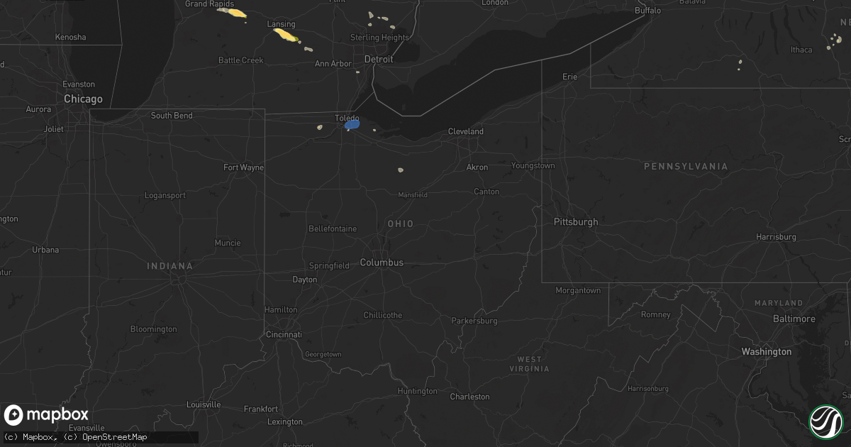
Hail Map in Ohio on June 20, 2024
Get this storm
June 20 map
$229
one time, instant access
Download today. No call, no setup
Keep the $229
Bought the map and want the full workflow? Apply the entire $229 to a subscription within 7 days. None of it is wasted.
Every map, not just this one
This buys you this map. Subscription and you get every map we run, in the markets you choose from a few cities to whole states to nationwide. Plus real-time alerts the moment a storm fires.
Contact data
Name, contact info, occupancy, even credit band for addresses in the footprint. You go from where it hit to who to call.
Become the source they trust
Unlimited branding weather history reports on demand. You already have the documented answer ready for the property owner, and you are the one who showed up with it.
Property data and RoofTrace estimates
Pull up any address you have got, its value and the exact code rules for that jurisdiction, straight from One Click Code. Then RoofTrace estimates the squares, pitch, and roof value, priced the way you price.
Storm reports in Ohio
Ohio
| Date | Description |
|---|---|
| 06/20/20246:30 PM CDT | Report from police chief in delta of large tree limbs down and power outages. Time estimated via radar. |
| 06/20/20246:30 PM CDT | A local report indicates 60 MPH wind near 2 NW Brailey |
| 06/20/20245:23 PM CDT | 5 power poles snapped along cummings road at latcha road. |
| 06/20/20245:23 PM CDT | Asos station ktdz toledo. |
| 06/19/20247:01 PM CDT | Several tree limbs down on roadway on state road 99 and egypt road. Time estimated via radar. |
All States Impacted by Hail Map on June 20, 2024
Cities Impacted by Hail Map on June 20, 2024
- Mineville, NY
- Port Henry, NY
- Moriah, NY
- Bath, NY
- Moriah Center, NY
- Vergennes, VT
- Bridport, VT
- Middlebury, VT
- Oxford, MI
- Leonard, MI
- Cameron, NY
- Salisbury, VT
- Brandon, VT
- Wanblee, SD
- Grand Rapids, MI
- Westport, NY
- Long Valley, SD
- Durango, CO
- Lowell, MI
- Ada, MI
- Chestertown, NY
- Canaan, NH
- Pagosa Springs, CO
- Bayfield, CO
- Genesee, PA
- Warrensburg, NY
- Lebanon, NH
- Alto, MI
- Ripton, VT
- Clarksville, MI
- South Hero, VT
- Plattsburgh, NY
- Enfield, NH
- Saranac, MI
- Bolton Landing, NY
- Peru, NY
- Diamond Point, NY
- Romeo, MI
- Washington, MI
- Lake Odessa, MI
- Ray, MI
- Armada, MI
- Rochester, MI
- Queensbury, NY
- Lake George, NY
- Gorham, ME
- Standish, ME
- Whitehall, NY
- Fort Ann, NY
- West Baldwin, ME
- Westfield, MA
- Deerfield, MA
- South Deerfield, MA
- Cincinnatus, NY
- Pitcher, NY
- Keeseville, NY
- Oakland, MI
- Hadley, NY
- Stony Creek, NY
- Bernardston, MA
- Windham, ME
- Ganado, AZ
- Willsboro, NY
- Hanover, NH
- Princeton, IA
- Rifle, CO
- New Baltimore, MI
- Macomb, MI
- Limington, ME
- Charlotte, VT
- Essex, NY
- East Thetford, VT
- Hudson Falls, NY
- Brattleboro, VT
- Rockford, MI
- Cedar Springs, MI
- Sparta, MI
- Lake Luzerne, NY
- Etna, NH
- Livermore, CO
- Marathon, NY
- Belmont, MI
- Comstock Park, MI
- Steep Falls, ME
- Chugwater, WY
- Stanford, MT
- Wheatland, WY
- McGraw, NY
- Howard City, MI
- Buxton, ME
- Shinglehouse, PA
- Hiram, ME
- Newaygo, MI
- Greenville, MI
- Thedford, NE
- Hobson, MT
- Coudersport, PA
- Towaoc, CO
- Moccasin, MT
- Roulette, PA
- Belding, MI
- Morley, MI
- Lansing, MI
- Dimondale, MI
- Charlotte, MI
- Shiprock, NM
- Yoder, WY
- Veteran, WY
- Holt, MI
- Valentine, NE
- Blanding, UT
- Whitney Point, NY
- Wood Lake, NE
- Mason, MI
- Torrington, WY
- Buena Vista, CO
- Johnstown, NE
- Romulus, MI
- Sebago, ME
- East Baldwin, ME
- Hemingford, NE
- Rumney, NH
- Jefferson, ME
- Whitefield, ME
- Newport, NH
- Thetford Center, VT
- Schaghticoke, NY
- Moore, MT
- Lewistown, MT
- Lyman, NE
- Morrill, NE
- Mitchell, NE
- Lingle, WY
- Longmont, CO
- Valley Falls, NY
- Greenwich, NY
- Cambridge, NY
- Dansville, MI
- Arvada, CO
- Gering, NE
- Scottsbluff, NE
- Harrison, NE
- Alliance, NE
- Gallup, NM
- Loveland, CO
- Johnstown, CO
- Berthoud, CO
- Milliken, CO
- Windsor, CO
- Mead, CO
- Buskirk, NY
- Shaftsbury, VT
- Bennington, VT
- Oak Harbor, OH
- Minatare, NE
- Harrisburg, NE
- Bayard, NE
- Melbeta, NE
- Mcgrew, NE
- Glade Park, CO
- Grand Junction, CO
- Ainsworth, NE
- Greenville, NY
- Westerlo, NY
- Stockbridge, MI
- Platteville, CO
- Greeley, CO
- Selkirk, NY
- Feura Bush, NY
- Kearny, AZ
- Johnsonville, NY
- Eaton, CO
- Ault, CO
- Superior, AZ
- Woodland, MI
- Pierce, CO
- Gateway, CO
- Coeymans Hollow, NY
- Alcove, NY
- Wheat Ridge, CO
- Carpenter, WY
- Glenmont, NY
- Gregory, MI
- Albany, NY
- Rensselaer, NY
- Delmar, NY
- Long Pine, NE
- Marsland, NE
- Fort Mcdowell, AZ
- West Sand Lake, NY
- East Greenbush, NY
- Perrysburg, OH
- Stony Ridge, OH
- Ravena, NY
- Troy, NY
- South Bethlehem, NY
- Wynantskill, NY
- Castleton On Hudson, NY
- Winkelman, AZ
- Farmington, NM
- Bloomfield, NM
- Rushville, NE
- Angora, NE
- Bridgeport, NE
- Merriman, NE
- Pine Bluffs, WY
- Stuyvesant, NY
- Grover, CO
- Colorado Springs, CO
- Forest Grove, MT
- Gordon, NE
- La Salle, CO
- Averill Park, NY
- Walbridge, OH
- Northwood, OH
- Millbury, OH
- Genoa, OH
- Cody, NE
- Chinook, MT
- Kinderhook, NY
- Stuyvesant Falls, NY
- Sedalia, CO
- Lake George, CO
- Vernon, VT
- Peridot, AZ
- Bassett, NE
- Schodack Landing, NY
- Tonto Basin, AZ
- Hudson, NY
- Coxsackie, NY
- Valatie, NY
- Niverville, NY
- Athens, NY
- Ellsworth, NE
- Hay Springs, NE
- Ghent, NY
- Canisteo, NY
- Grass Range, MT
- Roundup, MT
- Payson, AZ
- Delta, OH
- De Ruyter, NY
- Curtice, OH
- Williston, OH
- Martin, OH
- Clay Center, OH
- Oregon, OH
- Swanton, OH
- Chatham, NY
- Lyndon, IL
- Lakeside, NE
- Broadwater, NE
- Oshkosh, NE
- Lisco, NE
- Bingham, NE
- Morrison, IL
- Young, AZ
- Plymouth, OH
- Willard, OH
- Newport, NE
- Gregory, SD
- Reliance, SD
- Sedona, AZ
- Sunderland, MA
- Leverett, MA
- Montague, MA
- Hays, MT
- Philmont, NY
- Amherst, MA
- Hadley, MA
- Chadwick, IL
- Pine, AZ
- Happy Jack, AZ
- White River, SD
- Kilgore, NE
- Nenzel, NE
- Wood, SD
- West Springfield, MA
- Brusett, MT
- Stuart, NE
- Whitman, NE
- Ashby, NE
- Hyannis, NE
- Mullen, NE
- Atkinson, NE
- Dodson, MT
- Whiting, VT
- Shoreham, VT
- Plankinton, SD
- Amelia, NE
- White Lake, SD
- Sand Springs, MT
- Malta, MT
- Winslow, AZ
- Miller, SD
- Ree Heights, SD
- Emmet, NE
- Forsyth, MT
- Oneill, NE
- Hingham, MT
- Chambers, NE
- Fairfield, MT
- Hinsdale, MT
- Worthing, SD
- Lennox, SD


