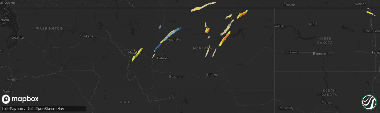
Hail Map in Montana on June 18, 2022
The weather event in Montana on June 18, 2022 includes Hail and Wind maps. 14 states and 270 cities were impacted and suffered possible damage. The total estimated number of properties impacted is 10,097.
Want more than just the map?
Turn this storm into a full workflow.
- Owner + property data so you know who to knock
- OnDemand branded weather history reports to win the "did we even have hail?" argument
- RoofTrace estimate so reps stop guessing numbers at the door
Bought this map? Upgrade within 7 days and we'll credit the $230. (10-15 min setup call)
Hail
Wind
10,097
Estimated number of impacted properties by a 1.00" hail or larger320
Estimated number of impacted properties by a 1.75" hail or larger0
Estimated number of impacted properties by a 2.50" hail or largerStorm reports in Montana
Montana
| Date | Description |
|---|---|
| 06/18/20226:47 PM CDT | Public report of two power poles snapped at the base. Additionally... Signs were reported to be blown over. Time estimated via radar. |
| 06/18/20226:27 PM CDT | Location and time corrected. Public report of two power poles snapped at the base on mt highway 232 at mile marker 21. Additionally... Signs were reported to be blown o |
| 06/18/20224:25 PM CDT | Awos station k1jm juliett observed a peak wind gust of 67 knots. |
| 06/18/20224:12 PM CDT | Numerous power poles snapped along i-15. Pea size hail and water filling the ditch. Time/location estimated. |
| 06/18/20224:05 PM CDT | Video showing hail was taken in sun river. Person who took the video reported up to quarter sized hail. Time estimated from radar. |
| 06/18/20223:52 PM CDT | Trained spotter reports quarter sized hail. Time estimated by radar. |
| 06/18/20223:45 PM CDT | Mesonet station ricmt rice ridge. |
| 06/18/20223:12 PM CDT | Facebook report. Hail size ranged between nickel sized to half dollar sized. Some dents/scratches on her car. |
| 06/18/20222:28 PM CDT | A local report indicates 1.00 inch wind near 3 NNE STEVENSVILLE |
| 06/18/20222:27 PM CDT | A local report indicates 1.00 inch wind near 2 WNW STEVENSVILLE |
| 06/18/20222:27 PM CDT | A local report indicates 1.00 inch wind near 2 ENE STEVENSVILLE |
| 06/18/20222:20 PM CDT | Facebook report. |
| 06/18/20222:07 PM CDT | Spotter called back after finding hail of 1 inch. |
| 06/18/20222:06 PM CDT | Twitter report. |
| 06/18/20226:36 AM CDT | At 1135 PM MDT, a severe thunderstorm was located 27 miles northeast of Devils Creek Rec Area, or 36 miles southwest of Glasgow, moving northeast at 50 mph. HAZARD...70 mph wind gusts and half dollar size hail. SOURCE...Radar indicated. IMPACT...Hail damage to vehicles is expected. Expect considerable tree damage. Wind damage is also likely to mobile homes, roofs, and outbuildings. Locations impacted include... Content and Sun Prairie. |
| 06/18/20225:41 AM CDT | At 1041 PM MDT, a severe thunderstorm was located 11 miles northeast of Saco, or 20 miles southeast of Whitewater, moving northeast at 20 mph. HAZARD...Quarter size hail. SOURCE...Radar indicated. IMPACT...Damage to vehicles is expected. Locations impacted include... Frenchman Reservoir. |
| 06/18/20225:40 AM CDT | Mesonet station ssmm8 devils creek rec area 6ese. |
| 06/18/20223:12 AM CDT | Quarter to golf ball sized hail. |
| 06/18/20222:58 AM CDT | At 757 PM MDT, a severe thunderstorm was located near Hays, or 10 miles west of Zortman, moving north at 20 mph. HAZARD...Ping pong ball size hail and 60 mph wind gusts. SOURCE...Radar indicated. IMPACT...People and animals outdoors will be injured. Expect hail damage to roofs, siding, windows, and vehicles. Expect wind damage to roofs, siding, and trees. Ponding of water on roadways will cause difficult driving on rural roads. Locations impacted include... Hays and Lodge Pole. |
| 06/18/20222:47 AM CDT | At 747 PM MDT, severe thunderstorms were located along a line extending from 7 miles southwest of Hays to 18 miles northeast of Roy, moving northeast at 25 mph. HAZARD...60 mph wind gusts and half dollar size hail. SOURCE...Radar indicated. IMPACT...Hail damage to vehicles is expected. Expect wind damage to roofs, siding, and trees. Locations impacted include... Zortman, Landusky and Fred Robinson Bridge. |
| 06/18/20222:32 AM CDT | At 732 PM MDT, a severe thunderstorm was located 13 miles southwest of Hays, or 16 miles west of Zortman, moving north at 10 mph. HAZARD...Two inch hail and 60 mph wind gusts. SOURCE...Radar indicated. IMPACT...People and animals outdoors will be injured. Expect hail damage to roofs, siding, windows, and vehicles. Expect wind damage to roofs, siding, and trees. This severe thunderstorm will remain over mainly rural areas of northeastern Fergus and south central Blaine Counties. |
| 06/18/20221:13 AM CDT | At 613 PM MDT, a severe thunderstorm was located 27 miles north of Chinook, moving northeast at 45 mph. HAZARD...Two inch hail and 70 mph wind gusts. SOURCE...Radar indicated. IMPACT...People and animals outdoors will be injured. Expect hail damage to roofs, siding, windows, and vehicles. Expect considerable tree damage. Wind damage is also likely to mobile homes, roofs, and outbuildings. This severe thunderstorm will remain over mainly rural areas of northwestern Blaine and northeastern Hill Counties. |
| 06/18/202212:38 AM CDT | At 538 PM MDT, severe thunderstorms were located along a line extending from 31 miles north of Gildford to 8 miles north of Beaver Creek, moving northeast at 55 mph. HAZARD...60 mph wind gusts and quarter size hail. SOURCE...Radar indicated. IMPACT...Hail damage to vehicles is expected. Expect wind damage to roofs, siding, and trees. These severe thunderstorms will remain over mainly rural areas of northwestern Blaine and northeastern Hill Counties. |
| 06/17/202210:56 PM CDT | At 356 PM MDT, a severe thunderstorm was located 10 miles southeast of The Knees, or 21 miles northwest of Fort Benton, moving northeast at 45 mph. HAZARD...70 mph wind gusts and ping pong ball size hail. SOURCE...Radar indicated. IMPACT...People and animals outdoors will be injured. Expect hail damage to roofs, siding, windows, and vehicles. Expect considerable tree damage. Wind damage is also likely to mobile homes, roofs, and outbuildings. Locations impacted include... Virgelle and Loma. |
| 06/17/202210:28 PM CDT | At 327 PM MDT, a severe thunderstorm was located 10 miles east of Power, or 19 miles northwest of Great Falls, moving northeast at 50 mph. HAZARD...Two inch hail and 70 mph wind gusts. SOURCE...Radar indicated. IMPACT...People and animals outdoors will be injured. Expect hail damage to roofs, siding, windows, and vehicles. Expect considerable tree damage. Wind damage is also likely to mobile homes, roofs, and outbuildings. Locations impacted include... The Knees and Carter. |
| 06/17/20229:59 PM CDT | At 258 PM MDT, a severe thunderstorm was located over Fort Shaw, or 17 miles north of Cascade, moving northeast at 45 mph. HAZARD...70 mph wind gusts and half dollar size hail. SOURCE...Radar indicated. IMPACT...Hail damage to vehicles is expected. Expect considerable tree damage. Wind damage is also likely to mobile homes, roofs, and outbuildings. Locations impacted include... Great Falls, Fort Shaw, Black Eagle, Vaughn, First Peoples Buffalo Jump State Park and Sun River. |
| 06/17/20229:36 PM CDT | At 235 PM MDT, a severe thunderstorm was located 16 miles northwest of Choteau, moving north northeast at 35 mph. HAZARD...60 mph wind gusts. SOURCE...Radar indicated. IMPACT...Expect damage to roofs, siding, and trees. Locations impacted include... Pendroy and Bynum. |
| 06/17/20229:31 PM CDT | At 231 PM MDT, a severe thunderstorm was located 15 miles southeast of Augusta, or 21 miles west of Cascade, moving northeast at 35 mph. HAZARD...70 mph wind gusts and quarter size hail. SOURCE...Radar indicated. IMPACT...Hail damage to vehicles is expected. Expect considerable tree damage. Wind damage is also likely to mobile homes, roofs, and outbuildings. Locations impacted include... Fairfield, Fort Shaw, Bowmans Corner, Simms and Sun River. |
| 06/17/20229:24 PM CDT | At 223 PM MDT, a severe thunderstorm was located 22 miles north of North Browning, or 28 miles northwest of Cut Bank, moving north at 35 mph. HAZARD...60 mph wind gusts and half dollar size hail. SOURCE...Radar indicated. IMPACT...Hail damage to vehicles is expected. Expect wind damage to roofs, siding, and trees. This severe thunderstorm will remain over mainly rural areas of north central Glacier County. |
| 06/17/20229:03 PM CDT | At 203 PM MDT, severe thunderstorms were located along a line extending from 13 miles south of Augusta to 14 miles northwest of Wolf Creek to 13 miles east of Lincoln, moving northeast at 40 mph. HAZARD...70 mph wind gusts and quarter size hail. SOURCE...Radar indicated. IMPACT...Hail damage to vehicles is expected. Expect considerable tree damage. Wind damage is also likely to mobile homes, roofs, and outbuildings. Locations impacted include... Augusta, Wolf Creek, Bowmans Corner, Bean Lake and Craig. |
| 06/17/20228:54 PM CDT | At 153 PM MDT, a severe thunderstorm was located 26 miles northwest of Augusta, or 34 miles west of Choteau, moving north at 35 mph. HAZARD...Half dollar size hail. SOURCE...Radar indicated. IMPACT...Damage to vehicles is expected. This severe thunderstorm will remain over mainly rural areas of northwestern Lewis and Clark and west central Teton Counties. |
| 06/17/20228:39 PM CDT | At 138 PM MDT, a severe thunderstorm was located 13 miles southeast of Lincoln, or 28 miles north of Deer Lodge, moving northeast at 30 mph. HAZARD...Ping pong ball size hail and 60 mph wind gusts. SOURCE...Radar indicated. IMPACT...People and animals outdoors will be injured. Expect hail damage to roofs, siding, windows, and vehicles. Expect wind damage to roofs, siding, and trees. This severe thunderstorm will remain over mainly rural areas of south central Lewis and Clark County. |
| 06/17/20228:34 PM CDT | At 133 PM MDT, a severe thunderstorm was located near Florence, or 12 miles south of Missoula, moving northeast at 45 mph. HAZARD...Quarter size hail. In addition wind gusts to 40 mph and heavy rain is anticipated. SOURCE...Radar indicated. IMPACT...Damage to vehicles is expected. Locations impacted include... Missoula, Lolo, Bonner-West Riverside, East Missoula, Evaro, Twin Creeks, Turah and Clinton. |
| 06/17/20228:28 PM CDT | At 128 PM MDT, a severe thunderstorm was located 15 miles south of Lincoln, or 24 miles north of Deer Lodge, moving northeast at 35 mph. HAZARD...60 mph wind gusts and quarter size hail. SOURCE...Radar indicated. IMPACT...Hail damage to vehicles is expected. Expect wind damage to roofs, siding, and trees. This severe thunderstorm will remain over mainly rural areas of south central Lewis and Clark County. |
| 06/17/20228:27 PM CDT | At 127 PM MDT, a severe thunderstorm was located near Lincoln, or 23 miles northeast of Drummond, moving north at 35 mph. HAZARD...60 mph wind gusts and quarter size hail. SOURCE...Radar indicated. IMPACT...Hail damage to vehicles is expected. Expect wind damage to roofs, siding, and trees. Locations impacted include... Lincoln. |
| 06/17/20228:20 PM CDT | At 119 PM MDT, a severe thunderstorm was located 12 miles northeast of Garrison, or 19 miles north of Deer Lodge, moving northeast at 30 mph. HAZARD...60 mph wind gusts and quarter size hail. SOURCE...Radar indicated. IMPACT...Hail damage to vehicles is expected. Expect wind damage to roofs, siding, and trees. Locations impacted include... Finn and Avon. |
| 06/17/20228:15 PM CDT | Mesonet station mtm42 blm roy. |
| 06/17/20228:15 PM CDT | At 115 PM MDT, a severe thunderstorm was located near Arlee, or 17 miles north of Missoula, moving north at 45 mph. HAZARD...60 mph wind gusts and quarter size hail. SOURCE...Radar indicated. IMPACT...Hail damage to vehicles is expected. Expect wind damage to roofs, siding, and trees. Locations impacted include... Ravalli, St. Ignatius, Arlee, Evaro, Allentown, Moiese, Kicking Horse, Charlo and Fort Connah. |
| 06/17/20228:14 PM CDT | At 114 AM MDT, a severe thunderstorm was located 9 miles north of North Browning, or 34 miles west of Cut Bank, moving northeast at 50 mph. HAZARD...60 mph wind gusts and half dollar size hail. SOURCE...Radar indicated. IMPACT...Hail damage to vehicles is expected. Expect wind damage to roofs, siding, and trees. Locations impacted include... North Browning and Starr School. |
| 06/17/20228:13 PM CDT | At 112 PM MDT, a severe thunderstorm was located over Victor, or 14 miles north of Hamilton, moving northeast at 25 mph. HAZARD...Quarter size hail. Winds gusting to 40 mph and heavy rain are also expected. SOURCE...Radar indicated. IMPACT...Damage to vehicles is expected. Locations impacted include... Lolo, Stevensville, Victor, Florence and Bell Crossing. |
All States Impacted by Hail Map on June 18, 2022
Cities Impacted by Hail Map on June 18, 2022
- Oklee, MN
- Brooks, MN
- Charleston, AR
- Vinita, OK
- Mccurtain, OK
- Peerless, MT
- Larslan, MT
- Richland, MT
- Opheim, MT
- Akeley, MN
- Hackensack, MN
- Walker, MN
- Winnett, MT
- Roundup, MT
- Grass Range, MT
- Eucha, OK
- Jay, OK
- Fairland, OK
- Grove, OK
- Afton, OK
- Miami, OK
- Booneville, AR
- Bethel, OK
- Coyle, OK
- Hinsdale, MT
- Lincoln, MT
- Welch, OK
- Perkins, OK
- Garrison, MT
- Avon, MT
- Winslow, AR
- Mountainburg, AR
- Weleetka, OK
- Hamilton, ND
- Lamar, OK
- Stuart, OK
- Mcalester, OK
- Hattiesburg, MS
- Sumrall, MS
- Chinook, MT
- Lloyd, MT
- Winifred, MT
- Roy, MT
- Okemah, OK
- Honobia, OK
- Belen, NM
- Floweree, MT
- Augusta, MT
- Vaughn, MT
- Carter, MT
- Sun River, MT
- Simms, MT
- Dutton, MT
- Power, MT
- Cascade, MT
- Fort Shaw, MT
- Conrad, MT
- Pendroy, MT
- Kennedy, MN
- Pembina, ND
- Drayton, ND
- Hallock, MN
- Hartshorne, OK
- Wilburton, OK
- Saco, MT
- Los Lunas, NM
- Lena, MS
- Brusett, MT
- Fort Peck, MT
- Vaughan, MS
- Pickens, MS
- Indianola, MS
- Laporte, MN
- Solway, MN
- Shevlin, MN
- Jessieville, AR
- Loxahatchee, FL
- Clarksville, TX
- Babson Park, FL
- Thoreau, NM
- Labelle, FL
- Lehigh Acres, FL
- Brandon, MS
- Cecil, AR
- Placitas, NM
- Nashville, AR
- Havre, MT
- Mingus, TX
- Hodgen, OK
- Heavener, OK
- Avon Park, FL
- Sebring, FL
- Carriere, MS
- Picayune, MS
- Waldron, AR
- Vancleave, MS
- Ocean Springs, MS
- Prairie Grove, AR
- West Fork, AR
- Stevensville, MT
- Canton, MS
- Moore Haven, FL
- Lithia, FL
- Breckenridge, TX
- Mulberry, FL
- Delight, AR
- McGehee, AR
- Dade City, FL
- Indianola, OK
- Kissimmee, FL
- Drew, MS
- Stephenville, TX
- Gurdon, AR
- Clermont, FL
- Winter Garden, FL
- Lakeland, FL
- Bonnerdale, AR
- Childress, TX
- Bartow, FL
- Eagle Lake, FL
- Winter Haven, FL
- Malta, MT
- Folkston, GA
- Holliday, TX
- North Port, FL
- Cedarville, AR
- Rudy, AR
- Hays, MT
- Zortman, MT
- Bernalillo, NM
- Algodones, NM
- Chidester, AR
- Valdosta, GA
- Orlando, FL
- Greenville, MS
- Bagwell, TX
- Fairfield, MT
- Fort Benton, MT
- Crowell, TX
- Tuskahoma, OK
- Graham, TX
- Sparks, OK
- Chandler, OK
- Victor, MT
- Florence, MT
- Bonner, MT
- Williston, FL
- Bronson, FL
- Morriston, FL
- Seminary, MS
- Ovett, MS
- Ellisville, MS
- Leesburg, FL
- Wildwood, FL
- The Villages, FL
- Mount Ida, AR
- Sarasota, FL
- Clinton, MT
- Florence, AZ
- Green Valley, AZ
- Amado, AZ
- Arcadia, FL
- Perkinston, MS
- Sparkman, AR
- Bearden, AR
- Lake Wales, FL
- Pinetta, FL
- Madison, FL
- Bentonia, MS
- Benton, MS
- Eloy, AZ
- Camden, AR
- Loving, TX
- Olney, TX
- Detroit, TX
- Bluejacket, OK
- Hampton, AR
- Albuquerque, NM
- Bosque Farms, NM
- Seeley Lake, MT
- Missoula, MT
- McIntosh, SD
- Holdenville, OK
- Nashoba, OK
- Haworth, OK
- Inglis, FL
- Chiefland, FL
- Otter Creek, FL
- Bonita, LA
- Cocoa, FL
- Wewoka, OK
- Seminole, OK
- Liberty, KS
- Clarksville, AR
- Cove, AR
- Wickes, AR
- Myakka City, FL
- Sawyer, OK
- Fort Towson, OK
- Dundee, FL
- Antlers, OK
- Donaldson, MN
- Wetumka, OK
- Montrose, AR
- Venice, FL
- Hilliard, FL
- Callahan, FL
- Paden, OK
- Boley, OK
- Superior, AZ
- Wellston, OK
- Coolidge, AZ
- San Tan Valley, AZ
- Mims, FL
- Titusville, FL
- Dierks, AR
- Indiantown, FL
- Okeechobee, FL
- Royal, AR
- Oden, AR
- Talihina, OK
- Alma, AR
- Tijeras, NM
- Poplarville, MS
- Floral City, FL
- Bushnell, FL
- Hamburg, AR
- Davenport, FL
- Cape Coral, FL
- Altoona, FL
- Umatilla, FL
- Goodman, MS
- Plant City, FL
- Haines City, FL
- Trail, MN
- New Augusta, MS
- Dermott, AR
- Eustis, FL
- Paisley, FL
- De Kalb, TX
- Tucson, AZ
- Groveland, FL
- Homestead, FL
- Bradenton, FL
- Camden, MS
- Forest, MS
- Milltown, MT
- Sims, AR
- Pencil Bluff, AR
- Muse, OK
- Smithville, OK
- Watson, OK
- Magdalena, NM
- Sunflower, MS
- Weirsdale, FL
- Ocklawaha, FL
- Lexington, MS
- Marana, AZ
- Frostproof, FL
- Brooksville, FL
- Ochopee, FL
- Melbourne, FL
- Saint Cloud, FL
- Malabar, FL
- Melbourne Beach, FL
- Dupree, SD
- Wolf Creek, MT
- Choteau, MT
- Bynum, MT
- Electra, TX


