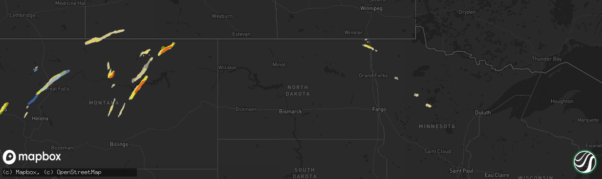
Hail Map in North Dakota on June 18, 2022
The weather event in North Dakota on June 18, 2022 includes Hail and Wind maps. 14 states and 270 cities were impacted and suffered possible damage. The total estimated number of properties impacted is 76.
Want more than just the map?
Turn this storm into a full workflow.
- Owner + property data so you know who to knock
- OnDemand branded weather history reports to win the "did we even have hail?" argument
- RoofTrace estimate so reps stop guessing numbers at the door
Bought this map? Upgrade within 7 days and we'll credit the $230. (10-15 min setup call)
Hail
Wind
76
Estimated number of impacted properties by a 1.00" hail or larger0
Estimated number of impacted properties by a 1.75" hail or larger0
Estimated number of impacted properties by a 2.50" hail or largerStorm reports in North Dakota
North Dakota
| Date | Description |
|---|---|
| 06/18/20228:10 AM CDT | A few dime to quarter sized hail. Quite glassy looking. |
| 06/18/20222:54 AM CDT | At 754 AM CDT, a severe thunderstorm was located near Hamilton, or 27 miles north of Grafton, moving east at 25 mph. HAZARD...60 mph wind gusts and quarter size hail. SOURCE...Radar indicated. IMPACT...Hail damage to vehicles is expected. Expect wind damage to roofs, siding, and trees. This severe thunderstorm will be near... Joliette around 810 AM CDT.Other locations in the path of this severe thunderstorm includeHumboldt and Northcote.This includes Interstate 29 between mile markers 192 and 211. |
All States Impacted by Hail Map on June 18, 2022
Cities Impacted by Hail Map on June 18, 2022
- Oklee, MN
- Brooks, MN
- Charleston, AR
- Vinita, OK
- Mccurtain, OK
- Peerless, MT
- Larslan, MT
- Richland, MT
- Opheim, MT
- Akeley, MN
- Hackensack, MN
- Walker, MN
- Winnett, MT
- Roundup, MT
- Grass Range, MT
- Eucha, OK
- Jay, OK
- Fairland, OK
- Grove, OK
- Afton, OK
- Miami, OK
- Booneville, AR
- Bethel, OK
- Coyle, OK
- Hinsdale, MT
- Lincoln, MT
- Welch, OK
- Perkins, OK
- Garrison, MT
- Avon, MT
- Winslow, AR
- Mountainburg, AR
- Weleetka, OK
- Hamilton, ND
- Lamar, OK
- Stuart, OK
- Mcalester, OK
- Hattiesburg, MS
- Sumrall, MS
- Chinook, MT
- Lloyd, MT
- Winifred, MT
- Roy, MT
- Okemah, OK
- Honobia, OK
- Belen, NM
- Floweree, MT
- Augusta, MT
- Vaughn, MT
- Carter, MT
- Sun River, MT
- Simms, MT
- Dutton, MT
- Power, MT
- Cascade, MT
- Fort Shaw, MT
- Conrad, MT
- Pendroy, MT
- Kennedy, MN
- Pembina, ND
- Drayton, ND
- Hallock, MN
- Hartshorne, OK
- Wilburton, OK
- Saco, MT
- Los Lunas, NM
- Lena, MS
- Brusett, MT
- Fort Peck, MT
- Vaughan, MS
- Pickens, MS
- Indianola, MS
- Laporte, MN
- Solway, MN
- Shevlin, MN
- Jessieville, AR
- Loxahatchee, FL
- Clarksville, TX
- Babson Park, FL
- Thoreau, NM
- Labelle, FL
- Lehigh Acres, FL
- Brandon, MS
- Cecil, AR
- Placitas, NM
- Nashville, AR
- Havre, MT
- Mingus, TX
- Hodgen, OK
- Heavener, OK
- Avon Park, FL
- Sebring, FL
- Carriere, MS
- Picayune, MS
- Waldron, AR
- Vancleave, MS
- Ocean Springs, MS
- Prairie Grove, AR
- West Fork, AR
- Stevensville, MT
- Canton, MS
- Moore Haven, FL
- Lithia, FL
- Breckenridge, TX
- Mulberry, FL
- Delight, AR
- McGehee, AR
- Dade City, FL
- Indianola, OK
- Kissimmee, FL
- Drew, MS
- Stephenville, TX
- Gurdon, AR
- Clermont, FL
- Winter Garden, FL
- Lakeland, FL
- Bonnerdale, AR
- Childress, TX
- Bartow, FL
- Eagle Lake, FL
- Winter Haven, FL
- Malta, MT
- Folkston, GA
- Holliday, TX
- North Port, FL
- Cedarville, AR
- Rudy, AR
- Hays, MT
- Zortman, MT
- Bernalillo, NM
- Algodones, NM
- Chidester, AR
- Valdosta, GA
- Orlando, FL
- Greenville, MS
- Bagwell, TX
- Fairfield, MT
- Fort Benton, MT
- Crowell, TX
- Tuskahoma, OK
- Graham, TX
- Sparks, OK
- Chandler, OK
- Victor, MT
- Florence, MT
- Bonner, MT
- Williston, FL
- Bronson, FL
- Morriston, FL
- Seminary, MS
- Ovett, MS
- Ellisville, MS
- Leesburg, FL
- Wildwood, FL
- The Villages, FL
- Mount Ida, AR
- Sarasota, FL
- Clinton, MT
- Florence, AZ
- Green Valley, AZ
- Amado, AZ
- Arcadia, FL
- Perkinston, MS
- Sparkman, AR
- Bearden, AR
- Lake Wales, FL
- Pinetta, FL
- Madison, FL
- Bentonia, MS
- Benton, MS
- Eloy, AZ
- Camden, AR
- Loving, TX
- Olney, TX
- Detroit, TX
- Bluejacket, OK
- Hampton, AR
- Albuquerque, NM
- Bosque Farms, NM
- Seeley Lake, MT
- Missoula, MT
- McIntosh, SD
- Holdenville, OK
- Nashoba, OK
- Haworth, OK
- Inglis, FL
- Chiefland, FL
- Otter Creek, FL
- Bonita, LA
- Cocoa, FL
- Wewoka, OK
- Seminole, OK
- Liberty, KS
- Clarksville, AR
- Cove, AR
- Wickes, AR
- Myakka City, FL
- Sawyer, OK
- Fort Towson, OK
- Dundee, FL
- Antlers, OK
- Donaldson, MN
- Wetumka, OK
- Montrose, AR
- Venice, FL
- Hilliard, FL
- Callahan, FL
- Paden, OK
- Boley, OK
- Superior, AZ
- Wellston, OK
- Coolidge, AZ
- San Tan Valley, AZ
- Mims, FL
- Titusville, FL
- Dierks, AR
- Indiantown, FL
- Okeechobee, FL
- Royal, AR
- Oden, AR
- Talihina, OK
- Alma, AR
- Tijeras, NM
- Poplarville, MS
- Floral City, FL
- Bushnell, FL
- Hamburg, AR
- Davenport, FL
- Cape Coral, FL
- Altoona, FL
- Umatilla, FL
- Goodman, MS
- Plant City, FL
- Haines City, FL
- Trail, MN
- New Augusta, MS
- Dermott, AR
- Eustis, FL
- Paisley, FL
- De Kalb, TX
- Tucson, AZ
- Groveland, FL
- Homestead, FL
- Bradenton, FL
- Camden, MS
- Forest, MS
- Milltown, MT
- Sims, AR
- Pencil Bluff, AR
- Muse, OK
- Smithville, OK
- Watson, OK
- Magdalena, NM
- Sunflower, MS
- Weirsdale, FL
- Ocklawaha, FL
- Lexington, MS
- Marana, AZ
- Frostproof, FL
- Brooksville, FL
- Ochopee, FL
- Melbourne, FL
- Saint Cloud, FL
- Malabar, FL
- Melbourne Beach, FL
- Dupree, SD
- Wolf Creek, MT
- Choteau, MT
- Bynum, MT
- Electra, TX


