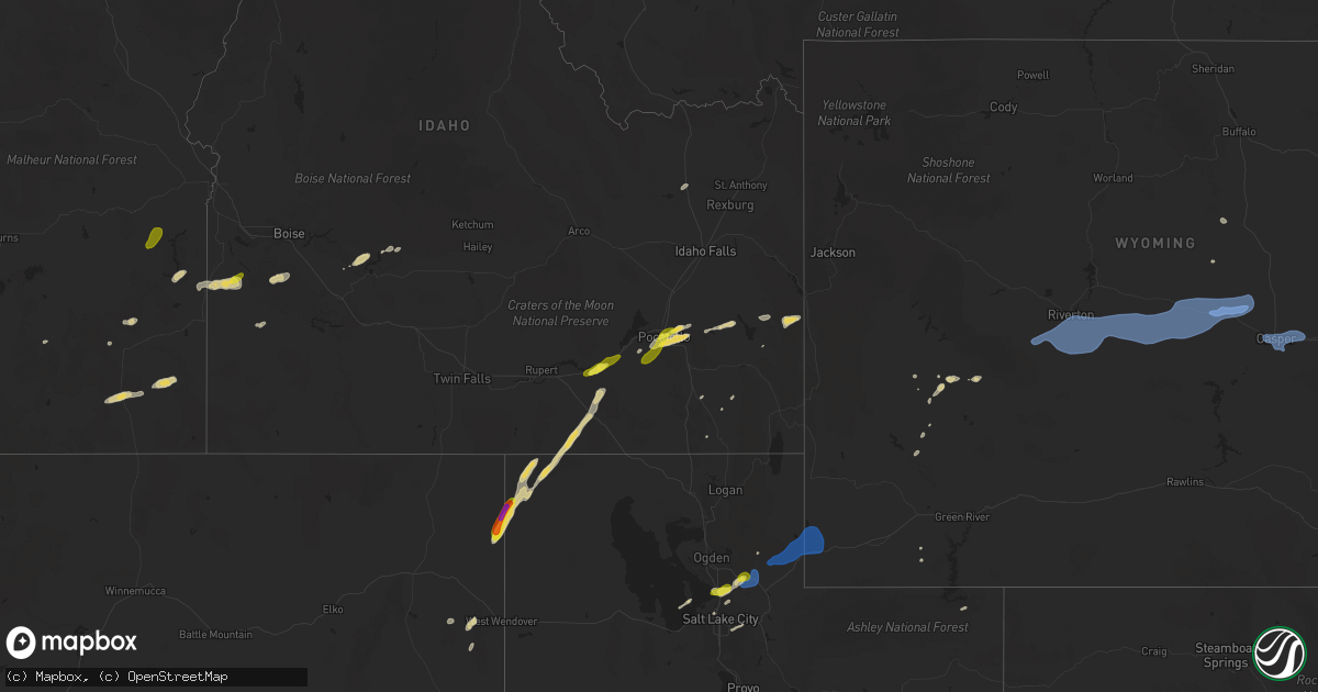
Hail Map on July 4, 2025
Get this storm
July 4 map
$229
one time, instant access
Download today. No call, no setup
Keep the $229
Bought the map and want the full workflow? Apply the entire $229 to a subscription within 7 days. None of it is wasted.
Every map, not just this one
This buys you this map. Subscription and you get every map we run, in the markets you choose from a few cities to whole states to nationwide. Plus real-time alerts the moment a storm fires.
Contact data
Name, contact info, occupancy, even credit band for addresses in the footprint. You go from where it hit to who to call.
Become the source they trust
Unlimited branding weather history reports on demand. You already have the documented answer ready for the property owner, and you are the one who showed up with it.
Property data and RoofTrace estimates
Pull up any address you have got, its value and the exact code rules for that jurisdiction, straight from One Click Code. Then RoofTrace estimates the squares, pitch, and roof value, priced the way you price.
States Impacted by Hail Map on July 4, 2025
Storm reports
Minnesota
| Date | Description |
|---|---|
| 07/04/20253:51 PM CDT | A few small trees were down with some small debris being picked up by the winds as well. |
| 07/04/20252:59 PM CDT | Corrects previous non thunderstorm wind gust report from 1 s international falls to a thunderstorm wind gust. Asos station kinl international falls airport. |
| 07/04/20251:00 PM CDT | Trees and a power line down... Location and time estimated from report/radar. Also unknown size of hail at time of report. |
| 07/04/202512:55 PM CDT | Facebook report of baseball sized hail. Time estimated. |
| 07/03/20259:57 PM CDT | Report via social media with photo. Several medium to large trees down... Partially over power lines. Time estimated from radar. |
| 07/03/20257:56 PM CDT | There were reports of several aspens down |
| 07/03/20257:45 PM CDT | There were reports of damage around potato lake with docks and boats missing. Time estimated via radar. |
North Dakota
| Date | Description |
|---|---|
| 07/04/20255:13 PM CDT | Delayed report: there was a report of tree branches down... Trampoline thrown about 150 yards... And wind gust of 59 mph recorded. Time estimated via radar. |
| 07/04/20255:11 PM CDT | Photos of tree damage (limbs ~ 5-6 inch |
| 07/04/20255:11 PM CDT | Photos of tree damage |
| 07/04/20254:26 PM CDT | A local report indicates 59 MPH wind near 4 SSW Galesburg |
| 07/04/20253:32 PM CDT | A local report indicates 61 MPH wind near 1 NNW Valley City |
| 07/04/20253:06 PM CDT | Ndawn 10 meter peak wind report. |
| 07/04/20252:56 PM CDT | Asos station kjms jamestown airport. |
| 07/04/20252:52 PM CDT | Ham radio operator report of quarter sized hail at parkhurst. |
Tennessee
| Date | Description |
|---|---|
| 07/04/20253:35 PM CDT | Several trees down. |
South Dakota
| Date | Description |
|---|---|
| 07/04/20253:30 PM CDT | Asos station kabr aberdeen rgnl ap. |
| 07/03/202510:15 PM CDT | A local report indicates 60 MPH wind near 11 W Hot Springs |
Idaho
| Date | Description |
|---|---|
| 07/04/20255:42 PM CDT | Tree down in the skyline drive area of sun valley. Time estimated via radar. |
| 07/04/20255:42 PM CDT | Tree down in the wyyakin drive area of sun valley. Time estimated via radar. |
| 07/04/20255:42 PM CDT | Tree down in the adams gulch area just outside of ketchum. Time estimated via radar. |
| 07/04/20255:00 PM CDT | Mesonet station sldmt 9.8 nw soldier |
| 07/04/20255:00 PM CDT | Mesonet station fafi 3.1 sw fairfield |
Georgia
| Date | Description |
|---|---|
| 07/04/20253:55 PM CDT | Several trees snapped or toppled on the 2000 block of skeenah gap rd. |
South Carolina
| Date | Description |
|---|---|
| 07/04/20255:52 PM CDT | Sumter county 911 dispatch reported trees down throughout the county. No specifics given. |
| 07/04/20255:48 PM CDT | Scdps website reported a tree in roadway at the intersection of church street and west hampton lane. Time estimated by radar. |
Alabama
| Date | Description |
|---|---|
| 07/04/20253:35 PM CDT | Reports of trees down across southern shelby county. Time estimated from radar. |
Utah
| Date | Description |
|---|---|
| 07/04/20256:40 PM CDT | Report from social media of a downed tree in kaysville from thunderstorm winds. Nearby mesonet stations reported gusts of 48 and 54 mph. |
| 07/03/20257:30 PM CDT | Stokes canyon pacificorp station gusted to 62 mph. |
| 07/03/20257:00 PM CDT | Photo received via social media. Time estimated by radar. |
Kansas
| Date | Description |
|---|---|
| 07/03/20258:40 PM CDT | Em reported downed 4 to 6 inch tree limbs. |
| 07/03/20258:40 PM CDT | A local report indicates 80 MPH wind near Ulysses |
| 07/03/20258:40 PM CDT | A bunch of big branches snapped blocking the road city had to come out with equipment and remove them. |
| 07/03/20257:00 PM CDT | A local report indicates 63 MPH wind near 1 S Coolidge |
Oregon
| Date | Description |
|---|---|
| 07/03/20258:24 PM CDT | Mesonet station gsfo3 grassy mountain. |
Colorado
| Date | Description |
|---|---|
| 07/04/20256:43 PM CDT | Weatherlink station wl-cope3.32w. |
| 07/04/20252:10 PM CDT | A local report indicates 62 MPH wind near 3 NNW Ellicott |
| 07/04/20251:24 PM CDT | A local report indicates 1.00 inch wind near 2 E Air Force Academy |
| 07/03/20257:20 PM CDT | Time estimated. |
| 07/03/20257:00 PM CDT | A local report indicates 59 MPH wind near 12 ENE Clarkville |
Wyoming
| Date | Description |
|---|---|
| 07/04/20256:52 PM CDT | Mesonet station wy61 i25 - hat six. |
| 07/04/20256:50 PM CDT | Claude creek... Wy pacificorp site. |
| 07/04/20256:50 PM CDT | Mesonet station pc576 horse ranch creek. |
| 07/04/20256:50 PM CDT | Casper mountain road... Wy pacificorp site. |
| 07/04/20256:50 PM CDT | Scenic drive... Wy pacificorp site. |
| 07/04/20256:42 PM CDT | Wy dot weather sensor. |
| 07/04/20256:42 PM CDT | Wy dot weather sensor. |
| 07/04/20256:20 PM CDT | Mesonet station rsnw4 hiland 16 s... Time estimate... Fales rock. |
| 07/04/20256:12 PM CDT | Wy dot weather station. |
| 07/04/20256:00 PM CDT | Mesonet station pc457 hidden dome. |
| 07/04/20255:47 PM CDT | Wy dot weather sensor. |
| 07/04/20255:40 PM CDT | 5 inch diameter tree branch fell on house... Report from trained spotter. Location approximate. |
| 07/04/20255:40 PM CDT | Time and location estimate; trees and powerlines down. |
| 07/04/20255:21 PM CDT | Asos station kgey greybull airport. |
| 07/04/20254:40 PM CDT | At nws riverton wfo... Measured gust from onsite weather station. |
| 07/04/20254:30 PM CDT | Pavilion... Wy cwop site. |
| 07/04/20254:27 PM CDT | A local report indicates 58 MPH wind near 1 S Lander |
| 07/03/20259:44 PM CDT | A local report indicates 58 MPH wind near 11 NE Morrisey |
| 07/03/20259:06 PM CDT | A local report indicates 60 MPH wind near 7 NNE Rochelle |
| 07/03/20258:34 PM CDT | A local report indicates 72 MPH wind near 1 N Wright |
| 07/03/20258:24 PM CDT | Corrects previous tstm wnd gst report from 8 ne bill to add staion information. Umrb station dcmw4 |
| 07/03/20258:24 PM CDT | Corrects previous tstm wnd gst report from 8 ne bill to add staion information. Um |
| 07/03/20258:00 PM CDT | Measured at the first divide wyoming dot rwis site. |
| 07/03/20258:00 PM CDT | Measured at the first divide wyoming dot |
| 07/03/20257:50 PM CDT | Measured at the evanston uinta county airport burns field asos. |
| 07/03/20257:20 PM CDT | Mesonet station pc602 glen rock rolling hills. |
Cities Impacted by Hail Map on July 4, 2025
- Grand Marais, MN
- Williams, MN
- New Brockton, AL
- Enterprise, AL
- Baudette, MN
- Daleville, AL
- Usaf Academy, CO
- Colorado Springs, CO
- Adrian, OR
- Chancellor, AL
- Murphy, ID
- Jordan Valley, OR
- Ashley, ND
- Zephyrhills, FL
- Geneva, AL
- Coffee Springs, AL
- Gackle, ND
- Grady, AL
- Jamestown, ND
- Luverne, AL
- Samson, AL
- Loman, MN
- Littlefork, MN
- International Falls, MN
- Highland Home, AL
- Edgeley, ND
- Big Piney, WY
- Pinedale, WY
- Chipley, FL
- Bonifay, FL
- Big Falls, MN
- Hope Hull, AL
- Sylacauga, AL
- Kulm, ND
- Hannaford, ND
- Leola, SD
- Wimbledon, ND
- Sanborn, ND
- Cooperstown, ND
- Shelby, AL
- Ypsilanti, ND
- Caryville, FL
- Columbiana, AL
- Spiritwood, ND
- Harrold, SD
- Ipswich, SD
- Birchdale, MN
- Kabetogama, MN
- Orr, MN
- Dazey, ND
- Rogers, ND
- Blunt, SD
- Jud, ND
- Cresbard, SD
- Frederick, SD
- Lowndesboro, AL
- Calera, AL
- Jemison, AL
- Clanton, AL
- Mountain Home, ID
- Prattville, AL
- Millbrook, AL
- Autaugaville, AL
- Boulder, WY
- Ault, CO
- Pierce, CO
- Aberdeen, SD
- Warner, SD
- Mansfield, SD
- Bath, SD
- Columbia, SD
- Luverne, ND
- Valley City, ND
- Oakes, ND
- Montello, NV
- Finley, ND
- Northville, SD
- Montgomery, AL
- East Grand Forks, MN
- Montevallo, AL
- Hope, ND
- Pillsbury, ND
- Clifford, ND
- Portland, ND
- Maplesville, AL
- Thief River Falls, MN
- Brierfield, AL
- Pike Road, AL
- Arlington, CO
- Reynolds, ND
- Wing, ND
- Euclid, MN
- Emerado, ND
- Andrews, NC
- Salt Lake City, UT
- Forsyth, MT
- Robinson, ND
- Grouse Creek, UT
- Park Valley, UT
- Mayville, ND
- Buxton, ND
- Hatton, ND
- Fisher, MN
- Thompson, ND
- Grand Forks, ND
- Carrington, ND
- Hayesville, NC
- Brooklet, GA
- Bessemer, AL
- Marion, AL
- Lawley, AL
- Centreville, AL
- Stanton, ND
- Ismay, MT
- Gladstone, ND
- Salmon, ID
- Leadore, ID
- Beulah, ND
- Kinsey, MT
- Denhoff, ND
- Ontario, OR
- Washburn, ND
- Belfield, ND
- Bowdon, ND
- Wilton, ND
- Mchenry, ND
- Springdale, MT
- Chaseley, ND
- Shepherd, MT
- Grace City, ND
- Richardton, ND
- Zap, ND
- Rapelje, MT
- Dickinson, ND
- Norris, MT
- Sykeston, ND
- Worden, MT
- Dillon, MT
- New Salem, ND
- Wibaux, MT
- Sheridan, MT
- Cascade, ID
- Vale, OR
- Mcclusky, ND
- Gallatin Gateway, MT
- McAllister, MT
- Center, ND
- Broadview, MT
- Reed Point, MT
- Glenfield, ND
- Medora, ND
- Bozeman, MT
- Manning, ND
- Binford, ND
- Sharon, ND
- Alder, MT
- Big Timber, MT
- Goodrich, ND
- Payette, ID
- Beach, ND
- Livingston, MT
- Regan, ND
- Fallon, MT
- Taylor, ND
- Halliday, ND
- Hazen, ND
- Sentinel Butte, ND
- Aneta, ND
- Hurdsfield, ND
- Climax, MN
- McCalla, AL
- West Blocton, AL
- American Falls, ID
- Malta, ID
- Helena, AL
- Elliott, SC
- Lynchburg, SC
- Bishopville, SC
- Mayesville, SC
- Fort Morgan, CO
- Crookston, MN
- Gillette, WY
- Colfax, ND
- Brookwood, AL
- Adger, AL
- Pocatello, ID
- Baxley, GA
- Merino, CO
- Lusk, WY
- Vance, AL
- Sumter, SC
- Declo, ID
- Wewahitchka, FL
- Snyder, CO
- Hazlehurst, GA
- Shoshoni, WY
- Casper, WY
- Hiland, WY
- Quinton, AL
- Park, KS
- Jeffrey City, WY
- Selden, KS
- Terry, MT
- Parrish, AL
- Oakman, AL
- Harrison, NE
- Crane Lake, MN
- Syracuse, KS
- Quinter, KS
- Centerville, UT
- Farmington, UT
- Birmingham, AL
- Mills, WY
- Evansville, WY
- Glenrock, WY
- Yuma, CO
- Haxtun, CO
- Newcastle, WY
- Dryden, TX
- Tribune, KS
- Inkom, ID
- Kaycee, WY
- Kit Carson, CO
- Morgan, UT
- Kaysville, UT
- Bountiful, UT
- Coalville, UT
- Henefer, UT
- Croydon, UT
- Holyoke, CO
- Courtenay, ND
- Grinnell, KS
- Eckley, CO
- Downey, ID
- Three Forks, MT
- Cleveland, ND
- Chadron, NE
- Manter, KS
- Winona, KS
- Wray, CO
- Grace, ID
- Oakley, KS
- Woodruff, UT
- Hay Springs, NE
- Johnson, KS
- Green River, WY
- Soda Springs, ID
- Evanston, WY
- Gove, KS
- Harrisburg, NE
- Alliance, NE
- Cope, CO
- Anton, CO
- Joes, CO
- Kirk, CO
- Wayan, ID
- Rushville, NE
- Angora, NE
- Bridgeport, NE
- Ulysses, KS
- Richfield, KS
- Merriman, NE
- Gordon, NE
- Healy, KS
- Burlington, CO
- Ellsworth, NE
- Broadwater, NE
- Rolla, KS
- Hamer, ID
- Lisco, NE
- Lodgepole, NE
- Oshkosh, NE
- Edgemont, SD
- Custer, SD
- Hot Springs, SD
- Hugoton, KS
- Hooker, OK
- Guymon, OK
- Plains, KS
- Forgan, OK
- Meade, KS
- Peyton, CO
- Calhan, CO
- Lander, WY
- Riverton, WY
- Hudson, WY
- Wright, WY
- Douglas, WY
- Burnet, TX
- Seibert, CO
- Marble Falls, TX