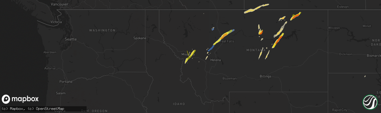
Hail Map on June 18, 2022
The weather event on June 18, 2022 includes Hail and Wind maps. 14 states and 270 cities were impacted and suffered possible damage. The total estimated number of properties impacted is 16,529.
Want more than just the map?
Turn this storm into a full workflow.
- Owner + property data so you know who to knock
- OnDemand branded weather history reports to win the "did we even have hail?" argument
- RoofTrace estimate so reps stop guessing numbers at the door
Bought this map? Upgrade within 7 days and we'll credit the $230. (10-15 min setup call)
Hail
Wind
16,529
Estimated number of impacted properties by a 1.00" hail or larger1,574
Estimated number of impacted properties by a 1.75" hail or larger0
Estimated number of impacted properties by a 2.50" hail or largerStates Impacted by Hail Map on June 18, 2022
Storm reports
Oklahoma
| Date | Description |
|---|---|
| 06/18/20224:52 AM CDT | At 952 PM CDT, a severe thunderstorm was located 4 miles west of Cromwell, moving northwest at 25 mph. HAZARD...60 mph wind gusts and penny size hail. SOURCE...Radar indicated. IMPACT...Expect damage to roofs, siding, and trees. Locations impacted include... Prague, Cromwell, Johnson, Little and Centerview. |
Florida
| Date | Description |
|---|---|
| 06/18/20223:46 PM CDT | Mesonet station lwef1 lake wales in highlands co. |
| 06/18/20223:41 PM CDT | Tree debris was reported covering sth 64 near zolfo springs. |
| 06/18/20223:39 PM CDT | Wxflow site rocky point measured a wind gust of 50kts/58mph from the northwest. |
| 06/18/20223:01 PM CDT | Mesonet station tt601 avon park afr north. |
| 06/18/20223:00 PM CDT | Snapchat video showed estimated quarter-sized hail in the avon park area. |
| 06/18/20222:16 PM CDT | Public report relayed by amateur radio. |
| 06/18/20221:45 PM CDT | Tree partially blocking the street near lake morton. |
| 06/18/20221:42 PM CDT | Picture of fallen large tree branch near the intersection of cypress springs pkwy and curry ford rd received via social media. |
| 06/18/20221:30 PM CDT | Tree partially blocking the street near lake morton. |
| 06/18/20221:30 PM CDT | Fence damage in the davenport area. |
| 06/18/202212:56 PM CDT | Delayed report. Lake county emergency management officials reported minor wind damage to four mobile homes and several large tree branches downed near the 36500th block |
| 06/18/20228:07 AM CDT | Trained spotter reported trees down blocking road. |
| 06/18/20223:40 AM CDT | Delayed report: alachua county 911/dispatch reports a tree downed by strong wind gusts along county road 231 just to the south of the intersection with county road 235 |
| 06/18/20222:50 AM CDT | Delayed report: alachua county 911/dispatch reports a tree downed by strong wind gusts near the intersection of nw 58th boulevard and nw 23rd avenue. Time of damage bas |
| 06/18/20221:20 AM CDT | At 619 PM EDT, a severe thunderstorm was located 8 miles northwest of Lion Country Safari Park, or 10 miles southeast of Canal Point, moving south at 10 mph. Another severe thunderstorm was just south of Port Mayaca and also moving south. HAZARD...60 mph wind gusts and quarter size hail. SOURCE...Radar indicated. IMPACT...Hail damage to vehicles is expected. Expect wind damage to roofs, siding, and trees. Locations impacted include... Lion Country Safari Park and Loxahatchee NWR. |
| 06/18/202212:13 AM CDT | At 513 PM EDT, severe thunderstorms were located along a line extending from 13 miles southeast of Southeast Arcadia to near Babcock Ranch to 8 miles north of Charlotte County Airport, moving south at 5 mph. HAZARD...60 mph wind gusts and quarter size hail. SOURCE...Radar indicated. IMPACT...Hail damage to vehicles is expected. Expect wind damage to roofs, siding, and trees. Locations impacted include... Cape Coral, Fort Myers Shores, Olga, North Fort Myers, Babcock Webb Wma, Charlotte County Airport, Tropical Gulf Acres, Babcock Ranch, Alva and Suncoast Estates. |
| 06/17/202211:52 PM CDT | At 452 PM EDT, severe thunderstorms were located along a line extending from 8 miles southeast of Arcadia to near Southeast Arcadia to 11 miles northeast of Port Charlotte, and are nearly stationary. HAZARD...60 mph wind gusts and quarter size hail. SOURCE...Radar indicated. IMPACT...Hail damage to vehicles is expected. Expect wind damage to roofs, siding, and trees. Locations impacted include... North Port, Punta Gorda, Arcadia, Southeast Arcadia, Nocatee, Babcock Ranch, Harbour Heights, Cleveland, Lake Suzy and Solana. |
| 06/17/202211:22 PM CDT | At 422 PM EDT, a severe thunderstorm was located near Sylvan Shores, or near Lake Placid, moving south at 35 mph. HAZARD...60 mph wind gusts and penny size hail. SOURCE...Radar indicated. IMPACT...Expect damage to roofs, siding, and trees. Locations impacted include... Lake Placid, Lake Josephine, Archbold, Placid Lakes, Venus and Sylvan Shores. |
| 06/17/202211:03 PM CDT | At 403 PM EDT, a severe thunderstorm was located near Myakka River State Park, or 15 miles north of North Port, and is nearly stationary. HAZARD...60 mph wind gusts and quarter size hail. SOURCE...Radar indicated. IMPACT...Hail damage to vehicles is expected. Expect wind damage to roofs, siding, and trees. Locations impacted include... Myakka City, Hidden River and Myakka River State Park. |
| 06/17/202210:51 PM CDT | At 351 PM EDT, a severe thunderstorm was located near Lone Cabbage Fish Camp, and is nearly stationary. HAZARD...60 mph wind gusts and quarter size hail. SOURCE...Radar indicated. IMPACT...Hail damage to vehicles is expected. Expect wind damage to roofs, siding, and trees. Locations impacted include... Cocoa, Canaveral Groves and Canaveral Acres. |
| 06/17/202210:34 PM CDT | At 334 PM EDT, a severe thunderstorm was located near North Port, and is nearly stationary. HAZARD...60 mph wind gusts and quarter size hail. SOURCE...Radar indicated. IMPACT...Hail damage to vehicles is expected. Expect wind damage to roofs, siding, and trees. Locations impacted include... North Port and Warm Mineral Springs. |
| 06/17/202210:19 PM CDT | At 319 PM EDT, a severe thunderstorm was located over Avon Park, and is nearly stationary. HAZARD...60 mph wind gusts and quarter size hail. SOURCE...Radar indicated. IMPACT...Hail damage to vehicles is expected. Expect wind damage to roofs, siding, and trees. Locations impacted include... Sebring, Avon Park, Sebring Shores and Avon Park Executive Airport. |
| 06/17/202210:13 PM CDT | At 313 PM EDT, a severe thunderstorm was located near Winter Haven, and is nearly stationary. HAZARD...60 mph wind gusts and quarter size hail. SOURCE...Radar indicated. IMPACT...Hail damage to vehicles is expected. Expect wind damage to roofs, siding, and trees. Locations impacted include... Winter Haven, Lake Wales, Crooked Lake Park, Dundee, Eagle Lake, Lake Hamilton, Hillcrest Heights, Highland Park, Alturas and Cypress Gardens. |
| 06/17/20229:29 PM CDT | At 229 PM EDT, a severe thunderstorm was located near Champions Gate, or 9 miles northwest of Haines City, moving southeast at 20 mph. HAZARD...60 mph wind gusts and quarter size hail. SOURCE...Radar indicated. IMPACT...Hail damage to vehicles is expected. Expect wind damage to roofs, siding, and trees. Locations impacted include... Poinciana, Winter Haven, Haines City, Lake Alfred, Davenport, Lake Hamilton and Loughman. |
| 06/17/20229:07 PM CDT | At 207 PM EDT, a severe thunderstorm was located near Horizon West, or near Winter Garden, moving southeast at 15 mph. HAZARD...60 mph wind gusts and penny size hail. SOURCE...Radar indicated. IMPACT...Expect damage to roofs, siding, and trees. Locations impacted include... Winter Garden, Bay Lake, Clermont, Oakland and Bay Hill. |
| 06/17/20228:59 PM CDT | At 159 PM EDT, a severe thunderstorm was located near Cassia, moving southeast at 15 mph. HAZARD...60 mph wind gusts and penny size hail. SOURCE...Radar indicated. IMPACT...Expect damage to roofs, siding, and trees. Locations impacted include... Sanford, Apopka, Lake Mary, Mount Plymouth and Cassia. |
| 06/17/20228:54 PM CDT | At 153 PM EDT, a severe thunderstorm was located near Groveland, moving southeast at 25 mph. HAZARD...60 mph wind gusts and penny size hail. SOURCE...Radar indicated. IMPACT...Expect damage to roofs, siding, and trees. Locations impacted include... Groveland, Bay Lake, Clermont, Lake Louisa and Minneola. |
| 06/17/20228:34 PM CDT | At 133 PM EDT, a severe thunderstorm was located over Mascotte, moving southeast at 25 mph. HAZARD...60 mph wind gusts and penny size hail. SOURCE...Radar indicated. IMPACT...Expect damage to roofs, siding, and trees. Locations impacted include... Groveland, Mascotte, Clermont, Lake Louisa and Minneola. |
South Dakota
| Date | Description |
|---|---|
| 06/18/20221:01 AM CDT | At 600 PM MDT, severe thunderstorms were located along a line extending from 3 miles north of Red Scaffold to 7 miles south of Intersection of Cherry Creek and Sunnybrook Roads to 5 miles south of Cherry Creek, moving northeast at 35 mph. HAZARD...60 mph wind gusts. SOURCE...Radar indicated. IMPACT...Expect damage to roofs, siding, and trees. Severe thunderstorms will be near... Intersection of Cherry Creek and Sunnybrook Roads around 615 PM MDT.Other locations in the path of these severe thunderstorms include RedElm, Dupree, Intersection of Highway 63 and BIA Road 8, Thunder Butteand South Eagle Butte. |
| 06/17/202211:16 PM CDT | At 416 PM MDT, a severe thunderstorm was located 4 miles northeast of Fairburn, or 23 miles east of Custer, moving northeast at 30 mph. HAZARD...60 mph wind gusts. SOURCE...Radar indicated. IMPACT...Expect damage to roofs, siding, and trees. This severe thunderstorm will be near... Hermosa around 425 PM MDT.Other locations in the path of this severe thunderstorm includeThompson Butte, Caputa, Farmingdale and Rapid City Airport. |
| 06/17/20227:36 PM CDT | Power line down in town...time estimated from radar |
| 06/17/20227:24 PM CDT | A local report indicates 60 MPH wind near 8 S DUPREE |
West Virginia
| Date | Description |
|---|---|
| 06/18/20222:35 PM CDT | Multiple trees and power lines down... Concentrated in the northern portion of the county... About from union wv to the county line. |
Arizona
| Date | Description |
|---|---|
| 06/18/20226:57 PM CDT | Several small branches broken from trees in the area. Half inch hail and 0.36 inches of rain. |
| 06/18/20226:10 PM CDT | Multiple trees and branches down in nw tucson. Damage was located between the intersections of la cholla blvd and oracle rd on w. Ina rd. Large tree down in whole foods |
| 06/17/202211:17 PM CDT | At 417 PM MST, a severe thunderstorm was located over Green Valley, moving north at 20 mph. HAZARD...60 mph wind gusts and quarter size hail. SOURCE...Radar indicated. IMPACT...Hail damage to vehicles is expected. Expect wind damage to roofs, siding, and trees. Locations impacted include... Sahuarita, Green Valley, East Sahuarita and Summit. |
Utah
| Date | Description |
|---|---|
| 06/18/20224:10 PM CDT | Pioneer crossing utpcr |
| 06/18/20223:50 PM CDT | Sr-68 at mp 16 mosida utlak |
Mississippi
| Date | Description |
|---|---|
| 06/18/20226:17 PM CDT | Picture of hail measuring 1.25 inches in diameter sent via social media. |
| 06/18/20226:15 PM CDT | Social media report of quarter sized hail in ocean springs. |
| 06/18/20226:08 PM CDT | Jackson county em reported golf ball sized hail at his house. |
| 06/18/20222:42 AM CDT | At 742 PM CDT, a severe thunderstorm was located near Oak Grove, or near West Hattiesburg, moving southwest at 15 mph. HAZARD...60 mph wind gusts and quarter size hail. SOURCE...Radar indicated. IMPACT...Hail damage to vehicles is expected. Expect wind damage to roofs, siding, and trees. This severe thunderstorm will be near... Pine Ridge around 750 PM CDT. Pinebur and Baxterville around 830 PM CDT. |
| 06/18/20221:09 AM CDT | At 608 PM CDT, a severe thunderstorm was located over Ocean Springs, moving south at 20 mph. HAZARD...Ping pong to golf ball size hail. SOURCE...Emergency management. IMPACT...People and animals outdoors will be injured. Expect damage to roofs, siding, windows, and vehicles. Locations impacted include... Biloxi, Ocean Springs, St. Martin, Gautier, D'iberville, Gulf Hills, Gulf Park Estates and Latimer.This includes the following Interstates... Interstate 10 in Mississippi between mile markers 49 and 59. Interstate 110 in Mississippi near mile marker 1. |
| 06/17/202211:01 PM CDT | At 401 PM CDT, a severe thunderstorm was located over Hillsboro, or near Harperville, moving southeast at 10 mph. HAZARD...60 mph wind gusts and quarter size hail. SOURCE...Radar indicated. IMPACT...Hail damage to vehicles is expected. Expect wind damage to roofs, siding, and trees. This severe thunderstorm will be near... Forest around 450 PM CDT. Homewood around 500 PM CDT. |
| 06/17/20229:36 PM CDT | At 236 PM CDT, a severe thunderstorm was located over Holly Ridge, or near Indianola, moving southwest at 20 mph. HAZARD...60 mph wind gusts and penny size hail. SOURCE...Radar indicated. IMPACT...Expect damage to roofs, siding, and trees. This severe thunderstorm will be near... Holly Ridge around 240 PM CDT. Leland and Tribbett around 305 PM CDT. |
North Dakota
| Date | Description |
|---|---|
| 06/18/20228:10 AM CDT | A few dime to quarter sized hail. Quite glassy looking. |
| 06/18/20222:54 AM CDT | At 754 AM CDT, a severe thunderstorm was located near Hamilton, or 27 miles north of Grafton, moving east at 25 mph. HAZARD...60 mph wind gusts and quarter size hail. SOURCE...Radar indicated. IMPACT...Hail damage to vehicles is expected. Expect wind damage to roofs, siding, and trees. This severe thunderstorm will be near... Joliette around 810 AM CDT.Other locations in the path of this severe thunderstorm includeHumboldt and Northcote.This includes Interstate 29 between mile markers 192 and 211. |
Georgia
| Date | Description |
|---|---|
| 06/18/20223:40 AM CDT | At 840 AM EDT, a severe thunderstorm was located over Hilliard, moving south at 20 mph. HAZARD...60 mph wind gusts and quarter size hail. SOURCE...Radar indicated. IMPACT...Hail damage to vehicles is expected. Expect wind damage to roofs, siding, and trees. Locations impacted include... Hilliard and Callahan. |
| 06/18/20222:53 AM CDT | At 752 AM EDT, a severe thunderstorm was located near I-75 At Exit 16, or near Lake Park, moving east at 35 mph. HAZARD...60 mph wind gusts and quarter size hail. SOURCE...Radar indicated. IMPACT...Hail damage to vehicles is expected. Expect wind damage to roofs, siding, and trees. Locations impacted include... Lake Park, Valdosta, I-75 At Exit 16, Remerton, Dasher, I-75 At Exit 5, Twin Lakes, Clyattville, I-75 At Exit 11, Valdosta Regional Airport and Kinderlou. |
Arkansas
| Date | Description |
|---|---|
| 06/18/20226:00 PM CDT | Trees down in nashville from outflow wind gust produced by thunderstorms east of town. Wind gusts near 50 mph. |
Texas
| Date | Description |
|---|---|
| 06/18/202212:57 AM CDT | At 557 PM CDT, a severe thunderstorm was located 4 miles east of Dundee, moving north at 15 mph. HAZARD...60 mph wind gusts and nickel size hail. SOURCE...Radar indicated. IMPACT...Expect damage to roofs, siding, and trees. Locations impacted include... Dundee, Mankins, Lake Kickapoo and Lake Diversion. |
| 06/18/202212:08 AM CDT | At 507 PM CDT, a severe thunderstorm was located 7 miles south of Lake Kickapoo, moving northwest at 15 mph. HAZARD...60 mph wind gusts and nickel size hail. SOURCE...Radar indicated. IMPACT...Expect damage to roofs, siding, and trees. Locations impacted include... Archer City, Megargel and Lake Kickapoo. |
Montana
| Date | Description |
|---|---|
| 06/18/20226:47 PM CDT | Public report of two power poles snapped at the base. Additionally... Signs were reported to be blown over. Time estimated via radar. |
| 06/18/20226:27 PM CDT | Location and time corrected. Public report of two power poles snapped at the base on mt highway 232 at mile marker 21. Additionally... Signs were reported to be blown o |
| 06/18/20224:25 PM CDT | Awos station k1jm juliett observed a peak wind gust of 67 knots. |
| 06/18/20224:12 PM CDT | Numerous power poles snapped along i-15. Pea size hail and water filling the ditch. Time/location estimated. |
| 06/18/20224:05 PM CDT | Video showing hail was taken in sun river. Person who took the video reported up to quarter sized hail. Time estimated from radar. |
| 06/18/20223:52 PM CDT | Trained spotter reports quarter sized hail. Time estimated by radar. |
| 06/18/20223:45 PM CDT | Mesonet station ricmt rice ridge. |
| 06/18/20223:12 PM CDT | Facebook report. Hail size ranged between nickel sized to half dollar sized. Some dents/scratches on her car. |
| 06/18/20222:28 PM CDT | A local report indicates 1.00 inch wind near 3 NNE STEVENSVILLE |
| 06/18/20222:27 PM CDT | A local report indicates 1.00 inch wind near 2 WNW STEVENSVILLE |
| 06/18/20222:27 PM CDT | A local report indicates 1.00 inch wind near 2 ENE STEVENSVILLE |
| 06/18/20222:20 PM CDT | Facebook report. |
| 06/18/20222:07 PM CDT | Spotter called back after finding hail of 1 inch. |
| 06/18/20222:06 PM CDT | Twitter report. |
| 06/18/20226:36 AM CDT | At 1135 PM MDT, a severe thunderstorm was located 27 miles northeast of Devils Creek Rec Area, or 36 miles southwest of Glasgow, moving northeast at 50 mph. HAZARD...70 mph wind gusts and half dollar size hail. SOURCE...Radar indicated. IMPACT...Hail damage to vehicles is expected. Expect considerable tree damage. Wind damage is also likely to mobile homes, roofs, and outbuildings. Locations impacted include... Content and Sun Prairie. |
| 06/18/20225:41 AM CDT | At 1041 PM MDT, a severe thunderstorm was located 11 miles northeast of Saco, or 20 miles southeast of Whitewater, moving northeast at 20 mph. HAZARD...Quarter size hail. SOURCE...Radar indicated. IMPACT...Damage to vehicles is expected. Locations impacted include... Frenchman Reservoir. |
| 06/18/20225:40 AM CDT | Mesonet station ssmm8 devils creek rec area 6ese. |
| 06/18/20223:12 AM CDT | Quarter to golf ball sized hail. |
| 06/18/20222:58 AM CDT | At 757 PM MDT, a severe thunderstorm was located near Hays, or 10 miles west of Zortman, moving north at 20 mph. HAZARD...Ping pong ball size hail and 60 mph wind gusts. SOURCE...Radar indicated. IMPACT...People and animals outdoors will be injured. Expect hail damage to roofs, siding, windows, and vehicles. Expect wind damage to roofs, siding, and trees. Ponding of water on roadways will cause difficult driving on rural roads. Locations impacted include... Hays and Lodge Pole. |
| 06/18/20222:47 AM CDT | At 747 PM MDT, severe thunderstorms were located along a line extending from 7 miles southwest of Hays to 18 miles northeast of Roy, moving northeast at 25 mph. HAZARD...60 mph wind gusts and half dollar size hail. SOURCE...Radar indicated. IMPACT...Hail damage to vehicles is expected. Expect wind damage to roofs, siding, and trees. Locations impacted include... Zortman, Landusky and Fred Robinson Bridge. |
| 06/18/20222:32 AM CDT | At 732 PM MDT, a severe thunderstorm was located 13 miles southwest of Hays, or 16 miles west of Zortman, moving north at 10 mph. HAZARD...Two inch hail and 60 mph wind gusts. SOURCE...Radar indicated. IMPACT...People and animals outdoors will be injured. Expect hail damage to roofs, siding, windows, and vehicles. Expect wind damage to roofs, siding, and trees. This severe thunderstorm will remain over mainly rural areas of northeastern Fergus and south central Blaine Counties. |
| 06/18/20221:13 AM CDT | At 613 PM MDT, a severe thunderstorm was located 27 miles north of Chinook, moving northeast at 45 mph. HAZARD...Two inch hail and 70 mph wind gusts. SOURCE...Radar indicated. IMPACT...People and animals outdoors will be injured. Expect hail damage to roofs, siding, windows, and vehicles. Expect considerable tree damage. Wind damage is also likely to mobile homes, roofs, and outbuildings. This severe thunderstorm will remain over mainly rural areas of northwestern Blaine and northeastern Hill Counties. |
| 06/18/202212:38 AM CDT | At 538 PM MDT, severe thunderstorms were located along a line extending from 31 miles north of Gildford to 8 miles north of Beaver Creek, moving northeast at 55 mph. HAZARD...60 mph wind gusts and quarter size hail. SOURCE...Radar indicated. IMPACT...Hail damage to vehicles is expected. Expect wind damage to roofs, siding, and trees. These severe thunderstorms will remain over mainly rural areas of northwestern Blaine and northeastern Hill Counties. |
| 06/17/202210:56 PM CDT | At 356 PM MDT, a severe thunderstorm was located 10 miles southeast of The Knees, or 21 miles northwest of Fort Benton, moving northeast at 45 mph. HAZARD...70 mph wind gusts and ping pong ball size hail. SOURCE...Radar indicated. IMPACT...People and animals outdoors will be injured. Expect hail damage to roofs, siding, windows, and vehicles. Expect considerable tree damage. Wind damage is also likely to mobile homes, roofs, and outbuildings. Locations impacted include... Virgelle and Loma. |
| 06/17/202210:28 PM CDT | At 327 PM MDT, a severe thunderstorm was located 10 miles east of Power, or 19 miles northwest of Great Falls, moving northeast at 50 mph. HAZARD...Two inch hail and 70 mph wind gusts. SOURCE...Radar indicated. IMPACT...People and animals outdoors will be injured. Expect hail damage to roofs, siding, windows, and vehicles. Expect considerable tree damage. Wind damage is also likely to mobile homes, roofs, and outbuildings. Locations impacted include... The Knees and Carter. |
| 06/17/20229:59 PM CDT | At 258 PM MDT, a severe thunderstorm was located over Fort Shaw, or 17 miles north of Cascade, moving northeast at 45 mph. HAZARD...70 mph wind gusts and half dollar size hail. SOURCE...Radar indicated. IMPACT...Hail damage to vehicles is expected. Expect considerable tree damage. Wind damage is also likely to mobile homes, roofs, and outbuildings. Locations impacted include... Great Falls, Fort Shaw, Black Eagle, Vaughn, First Peoples Buffalo Jump State Park and Sun River. |
| 06/17/20229:36 PM CDT | At 235 PM MDT, a severe thunderstorm was located 16 miles northwest of Choteau, moving north northeast at 35 mph. HAZARD...60 mph wind gusts. SOURCE...Radar indicated. IMPACT...Expect damage to roofs, siding, and trees. Locations impacted include... Pendroy and Bynum. |
| 06/17/20229:31 PM CDT | At 231 PM MDT, a severe thunderstorm was located 15 miles southeast of Augusta, or 21 miles west of Cascade, moving northeast at 35 mph. HAZARD...70 mph wind gusts and quarter size hail. SOURCE...Radar indicated. IMPACT...Hail damage to vehicles is expected. Expect considerable tree damage. Wind damage is also likely to mobile homes, roofs, and outbuildings. Locations impacted include... Fairfield, Fort Shaw, Bowmans Corner, Simms and Sun River. |
| 06/17/20229:24 PM CDT | At 223 PM MDT, a severe thunderstorm was located 22 miles north of North Browning, or 28 miles northwest of Cut Bank, moving north at 35 mph. HAZARD...60 mph wind gusts and half dollar size hail. SOURCE...Radar indicated. IMPACT...Hail damage to vehicles is expected. Expect wind damage to roofs, siding, and trees. This severe thunderstorm will remain over mainly rural areas of north central Glacier County. |
| 06/17/20229:03 PM CDT | At 203 PM MDT, severe thunderstorms were located along a line extending from 13 miles south of Augusta to 14 miles northwest of Wolf Creek to 13 miles east of Lincoln, moving northeast at 40 mph. HAZARD...70 mph wind gusts and quarter size hail. SOURCE...Radar indicated. IMPACT...Hail damage to vehicles is expected. Expect considerable tree damage. Wind damage is also likely to mobile homes, roofs, and outbuildings. Locations impacted include... Augusta, Wolf Creek, Bowmans Corner, Bean Lake and Craig. |
| 06/17/20228:54 PM CDT | At 153 PM MDT, a severe thunderstorm was located 26 miles northwest of Augusta, or 34 miles west of Choteau, moving north at 35 mph. HAZARD...Half dollar size hail. SOURCE...Radar indicated. IMPACT...Damage to vehicles is expected. This severe thunderstorm will remain over mainly rural areas of northwestern Lewis and Clark and west central Teton Counties. |
| 06/17/20228:39 PM CDT | At 138 PM MDT, a severe thunderstorm was located 13 miles southeast of Lincoln, or 28 miles north of Deer Lodge, moving northeast at 30 mph. HAZARD...Ping pong ball size hail and 60 mph wind gusts. SOURCE...Radar indicated. IMPACT...People and animals outdoors will be injured. Expect hail damage to roofs, siding, windows, and vehicles. Expect wind damage to roofs, siding, and trees. This severe thunderstorm will remain over mainly rural areas of south central Lewis and Clark County. |
| 06/17/20228:34 PM CDT | At 133 PM MDT, a severe thunderstorm was located near Florence, or 12 miles south of Missoula, moving northeast at 45 mph. HAZARD...Quarter size hail. In addition wind gusts to 40 mph and heavy rain is anticipated. SOURCE...Radar indicated. IMPACT...Damage to vehicles is expected. Locations impacted include... Missoula, Lolo, Bonner-West Riverside, East Missoula, Evaro, Twin Creeks, Turah and Clinton. |
| 06/17/20228:28 PM CDT | At 128 PM MDT, a severe thunderstorm was located 15 miles south of Lincoln, or 24 miles north of Deer Lodge, moving northeast at 35 mph. HAZARD...60 mph wind gusts and quarter size hail. SOURCE...Radar indicated. IMPACT...Hail damage to vehicles is expected. Expect wind damage to roofs, siding, and trees. This severe thunderstorm will remain over mainly rural areas of south central Lewis and Clark County. |
| 06/17/20228:27 PM CDT | At 127 PM MDT, a severe thunderstorm was located near Lincoln, or 23 miles northeast of Drummond, moving north at 35 mph. HAZARD...60 mph wind gusts and quarter size hail. SOURCE...Radar indicated. IMPACT...Hail damage to vehicles is expected. Expect wind damage to roofs, siding, and trees. Locations impacted include... Lincoln. |
| 06/17/20228:20 PM CDT | At 119 PM MDT, a severe thunderstorm was located 12 miles northeast of Garrison, or 19 miles north of Deer Lodge, moving northeast at 30 mph. HAZARD...60 mph wind gusts and quarter size hail. SOURCE...Radar indicated. IMPACT...Hail damage to vehicles is expected. Expect wind damage to roofs, siding, and trees. Locations impacted include... Finn and Avon. |
| 06/17/20228:15 PM CDT | Mesonet station mtm42 blm roy. |
| 06/17/20228:15 PM CDT | At 115 PM MDT, a severe thunderstorm was located near Arlee, or 17 miles north of Missoula, moving north at 45 mph. HAZARD...60 mph wind gusts and quarter size hail. SOURCE...Radar indicated. IMPACT...Hail damage to vehicles is expected. Expect wind damage to roofs, siding, and trees. Locations impacted include... Ravalli, St. Ignatius, Arlee, Evaro, Allentown, Moiese, Kicking Horse, Charlo and Fort Connah. |
| 06/17/20228:14 PM CDT | At 114 AM MDT, a severe thunderstorm was located 9 miles north of North Browning, or 34 miles west of Cut Bank, moving northeast at 50 mph. HAZARD...60 mph wind gusts and half dollar size hail. SOURCE...Radar indicated. IMPACT...Hail damage to vehicles is expected. Expect wind damage to roofs, siding, and trees. Locations impacted include... North Browning and Starr School. |
| 06/17/20228:13 PM CDT | At 112 PM MDT, a severe thunderstorm was located over Victor, or 14 miles north of Hamilton, moving northeast at 25 mph. HAZARD...Quarter size hail. Winds gusting to 40 mph and heavy rain are also expected. SOURCE...Radar indicated. IMPACT...Damage to vehicles is expected. Locations impacted include... Lolo, Stevensville, Victor, Florence and Bell Crossing. |
Cities Impacted by Hail Map on June 18, 2022
- Oklee, MN
- Brooks, MN
- Charleston, AR
- Vinita, OK
- Mccurtain, OK
- Peerless, MT
- Larslan, MT
- Richland, MT
- Opheim, MT
- Akeley, MN
- Hackensack, MN
- Walker, MN
- Winnett, MT
- Roundup, MT
- Grass Range, MT
- Eucha, OK
- Jay, OK
- Fairland, OK
- Grove, OK
- Afton, OK
- Miami, OK
- Booneville, AR
- Bethel, OK
- Coyle, OK
- Hinsdale, MT
- Lincoln, MT
- Welch, OK
- Perkins, OK
- Garrison, MT
- Avon, MT
- Winslow, AR
- Mountainburg, AR
- Weleetka, OK
- Hamilton, ND
- Lamar, OK
- Stuart, OK
- Mcalester, OK
- Hattiesburg, MS
- Sumrall, MS
- Chinook, MT
- Lloyd, MT
- Winifred, MT
- Roy, MT
- Okemah, OK
- Honobia, OK
- Belen, NM
- Floweree, MT
- Augusta, MT
- Vaughn, MT
- Carter, MT
- Sun River, MT
- Simms, MT
- Dutton, MT
- Power, MT
- Cascade, MT
- Fort Shaw, MT
- Conrad, MT
- Pendroy, MT
- Kennedy, MN
- Pembina, ND
- Drayton, ND
- Hallock, MN
- Hartshorne, OK
- Wilburton, OK
- Saco, MT
- Los Lunas, NM
- Lena, MS
- Brusett, MT
- Fort Peck, MT
- Vaughan, MS
- Pickens, MS
- Indianola, MS
- Laporte, MN
- Solway, MN
- Shevlin, MN
- Jessieville, AR
- Loxahatchee, FL
- Clarksville, TX
- Babson Park, FL
- Thoreau, NM
- Labelle, FL
- Lehigh Acres, FL
- Brandon, MS
- Cecil, AR
- Placitas, NM
- Nashville, AR
- Havre, MT
- Mingus, TX
- Hodgen, OK
- Heavener, OK
- Avon Park, FL
- Sebring, FL
- Carriere, MS
- Picayune, MS
- Waldron, AR
- Vancleave, MS
- Ocean Springs, MS
- Prairie Grove, AR
- West Fork, AR
- Stevensville, MT
- Canton, MS
- Moore Haven, FL
- Lithia, FL
- Breckenridge, TX
- Mulberry, FL
- Delight, AR
- McGehee, AR
- Dade City, FL
- Indianola, OK
- Kissimmee, FL
- Drew, MS
- Stephenville, TX
- Gurdon, AR
- Clermont, FL
- Winter Garden, FL
- Lakeland, FL
- Bonnerdale, AR
- Childress, TX
- Bartow, FL
- Eagle Lake, FL
- Winter Haven, FL
- Malta, MT
- Folkston, GA
- Holliday, TX
- North Port, FL
- Cedarville, AR
- Rudy, AR
- Hays, MT
- Zortman, MT
- Bernalillo, NM
- Algodones, NM
- Chidester, AR
- Valdosta, GA
- Orlando, FL
- Greenville, MS
- Bagwell, TX
- Fairfield, MT
- Fort Benton, MT
- Crowell, TX
- Tuskahoma, OK
- Graham, TX
- Sparks, OK
- Chandler, OK
- Victor, MT
- Florence, MT
- Bonner, MT
- Williston, FL
- Bronson, FL
- Morriston, FL
- Seminary, MS
- Ovett, MS
- Ellisville, MS
- Leesburg, FL
- Wildwood, FL
- The Villages, FL
- Mount Ida, AR
- Sarasota, FL
- Clinton, MT
- Florence, AZ
- Green Valley, AZ
- Amado, AZ
- Arcadia, FL
- Perkinston, MS
- Sparkman, AR
- Bearden, AR
- Lake Wales, FL
- Pinetta, FL
- Madison, FL
- Bentonia, MS
- Benton, MS
- Eloy, AZ
- Camden, AR
- Loving, TX
- Olney, TX
- Detroit, TX
- Bluejacket, OK
- Hampton, AR
- Albuquerque, NM
- Bosque Farms, NM
- Seeley Lake, MT
- Missoula, MT
- McIntosh, SD
- Holdenville, OK
- Nashoba, OK
- Haworth, OK
- Inglis, FL
- Chiefland, FL
- Otter Creek, FL
- Bonita, LA
- Cocoa, FL
- Wewoka, OK
- Seminole, OK
- Liberty, KS
- Clarksville, AR
- Cove, AR
- Wickes, AR
- Myakka City, FL
- Sawyer, OK
- Fort Towson, OK
- Dundee, FL
- Antlers, OK
- Donaldson, MN
- Wetumka, OK
- Montrose, AR
- Venice, FL
- Hilliard, FL
- Callahan, FL
- Paden, OK
- Boley, OK
- Superior, AZ
- Wellston, OK
- Coolidge, AZ
- San Tan Valley, AZ
- Mims, FL
- Titusville, FL
- Dierks, AR
- Indiantown, FL
- Okeechobee, FL
- Royal, AR
- Oden, AR
- Talihina, OK
- Alma, AR
- Tijeras, NM
- Poplarville, MS
- Floral City, FL
- Bushnell, FL
- Hamburg, AR
- Davenport, FL
- Cape Coral, FL
- Altoona, FL
- Umatilla, FL
- Goodman, MS
- Plant City, FL
- Haines City, FL
- Trail, MN
- New Augusta, MS
- Dermott, AR
- Eustis, FL
- Paisley, FL
- De Kalb, TX
- Tucson, AZ
- Groveland, FL
- Homestead, FL
- Bradenton, FL
- Camden, MS
- Forest, MS
- Milltown, MT
- Sims, AR
- Pencil Bluff, AR
- Muse, OK
- Smithville, OK
- Watson, OK
- Magdalena, NM
- Sunflower, MS
- Weirsdale, FL
- Ocklawaha, FL
- Lexington, MS
- Marana, AZ
- Frostproof, FL
- Brooksville, FL
- Ochopee, FL
- Melbourne, FL
- Saint Cloud, FL
- Malabar, FL
- Melbourne Beach, FL
- Dupree, SD
- Wolf Creek, MT
- Choteau, MT
- Bynum, MT
- Electra, TX