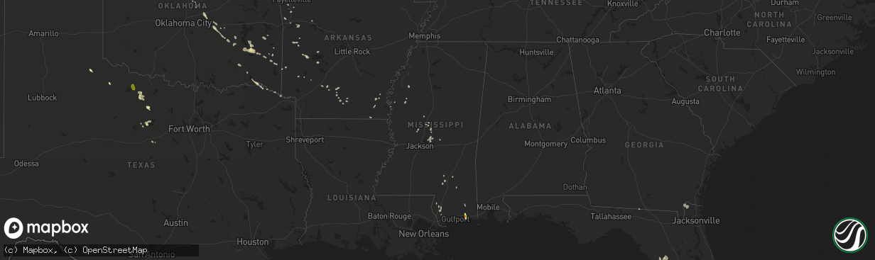
Hail Map in Mississippi on June 18, 2022
The weather event in Mississippi on June 18, 2022 includes Hail and Wind maps. 14 states and 270 cities were impacted and suffered possible damage. The total estimated number of properties impacted is 4,733.
Want more than just the map?
Turn this storm into a full workflow.
- Owner + property data so you know who to knock
- OnDemand branded weather history reports to win the "did we even have hail?" argument
- RoofTrace estimate so reps stop guessing numbers at the door
Bought this map? Upgrade within 7 days and we'll credit the $230. (10-15 min setup call)
Hail
Wind
4,733
Estimated number of impacted properties by a 1.00" hail or larger552
Estimated number of impacted properties by a 1.75" hail or larger0
Estimated number of impacted properties by a 2.50" hail or largerStorm reports in Mississippi
Mississippi
| Date | Description |
|---|---|
| 06/18/20226:17 PM CDT | Picture of hail measuring 1.25 inches in diameter sent via social media. |
| 06/18/20226:15 PM CDT | Social media report of quarter sized hail in ocean springs. |
| 06/18/20226:08 PM CDT | Jackson county em reported golf ball sized hail at his house. |
| 06/18/20222:42 AM CDT | At 742 PM CDT, a severe thunderstorm was located near Oak Grove, or near West Hattiesburg, moving southwest at 15 mph. HAZARD...60 mph wind gusts and quarter size hail. SOURCE...Radar indicated. IMPACT...Hail damage to vehicles is expected. Expect wind damage to roofs, siding, and trees. This severe thunderstorm will be near... Pine Ridge around 750 PM CDT. Pinebur and Baxterville around 830 PM CDT. |
| 06/18/20221:09 AM CDT | At 608 PM CDT, a severe thunderstorm was located over Ocean Springs, moving south at 20 mph. HAZARD...Ping pong to golf ball size hail. SOURCE...Emergency management. IMPACT...People and animals outdoors will be injured. Expect damage to roofs, siding, windows, and vehicles. Locations impacted include... Biloxi, Ocean Springs, St. Martin, Gautier, D'iberville, Gulf Hills, Gulf Park Estates and Latimer.This includes the following Interstates... Interstate 10 in Mississippi between mile markers 49 and 59. Interstate 110 in Mississippi near mile marker 1. |
| 06/17/202211:01 PM CDT | At 401 PM CDT, a severe thunderstorm was located over Hillsboro, or near Harperville, moving southeast at 10 mph. HAZARD...60 mph wind gusts and quarter size hail. SOURCE...Radar indicated. IMPACT...Hail damage to vehicles is expected. Expect wind damage to roofs, siding, and trees. This severe thunderstorm will be near... Forest around 450 PM CDT. Homewood around 500 PM CDT. |
| 06/17/20229:36 PM CDT | At 236 PM CDT, a severe thunderstorm was located over Holly Ridge, or near Indianola, moving southwest at 20 mph. HAZARD...60 mph wind gusts and penny size hail. SOURCE...Radar indicated. IMPACT...Expect damage to roofs, siding, and trees. This severe thunderstorm will be near... Holly Ridge around 240 PM CDT. Leland and Tribbett around 305 PM CDT. |
All States Impacted by Hail Map on June 18, 2022
Cities Impacted by Hail Map on June 18, 2022
- Oklee, MN
- Brooks, MN
- Charleston, AR
- Vinita, OK
- Mccurtain, OK
- Peerless, MT
- Larslan, MT
- Richland, MT
- Opheim, MT
- Akeley, MN
- Hackensack, MN
- Walker, MN
- Winnett, MT
- Roundup, MT
- Grass Range, MT
- Eucha, OK
- Jay, OK
- Fairland, OK
- Grove, OK
- Afton, OK
- Miami, OK
- Booneville, AR
- Bethel, OK
- Coyle, OK
- Hinsdale, MT
- Lincoln, MT
- Welch, OK
- Perkins, OK
- Garrison, MT
- Avon, MT
- Winslow, AR
- Mountainburg, AR
- Weleetka, OK
- Hamilton, ND
- Lamar, OK
- Stuart, OK
- Mcalester, OK
- Hattiesburg, MS
- Sumrall, MS
- Chinook, MT
- Lloyd, MT
- Winifred, MT
- Roy, MT
- Okemah, OK
- Honobia, OK
- Belen, NM
- Floweree, MT
- Augusta, MT
- Vaughn, MT
- Carter, MT
- Sun River, MT
- Simms, MT
- Dutton, MT
- Power, MT
- Cascade, MT
- Fort Shaw, MT
- Conrad, MT
- Pendroy, MT
- Kennedy, MN
- Pembina, ND
- Drayton, ND
- Hallock, MN
- Hartshorne, OK
- Wilburton, OK
- Saco, MT
- Los Lunas, NM
- Lena, MS
- Brusett, MT
- Fort Peck, MT
- Vaughan, MS
- Pickens, MS
- Indianola, MS
- Laporte, MN
- Solway, MN
- Shevlin, MN
- Jessieville, AR
- Loxahatchee, FL
- Clarksville, TX
- Babson Park, FL
- Thoreau, NM
- Labelle, FL
- Lehigh Acres, FL
- Brandon, MS
- Cecil, AR
- Placitas, NM
- Nashville, AR
- Havre, MT
- Mingus, TX
- Hodgen, OK
- Heavener, OK
- Avon Park, FL
- Sebring, FL
- Carriere, MS
- Picayune, MS
- Waldron, AR
- Vancleave, MS
- Ocean Springs, MS
- Prairie Grove, AR
- West Fork, AR
- Stevensville, MT
- Canton, MS
- Moore Haven, FL
- Lithia, FL
- Breckenridge, TX
- Mulberry, FL
- Delight, AR
- McGehee, AR
- Dade City, FL
- Indianola, OK
- Kissimmee, FL
- Drew, MS
- Stephenville, TX
- Gurdon, AR
- Clermont, FL
- Winter Garden, FL
- Lakeland, FL
- Bonnerdale, AR
- Childress, TX
- Bartow, FL
- Eagle Lake, FL
- Winter Haven, FL
- Malta, MT
- Folkston, GA
- Holliday, TX
- North Port, FL
- Cedarville, AR
- Rudy, AR
- Hays, MT
- Zortman, MT
- Bernalillo, NM
- Algodones, NM
- Chidester, AR
- Valdosta, GA
- Orlando, FL
- Greenville, MS
- Bagwell, TX
- Fairfield, MT
- Fort Benton, MT
- Crowell, TX
- Tuskahoma, OK
- Graham, TX
- Sparks, OK
- Chandler, OK
- Victor, MT
- Florence, MT
- Bonner, MT
- Williston, FL
- Bronson, FL
- Morriston, FL
- Seminary, MS
- Ovett, MS
- Ellisville, MS
- Leesburg, FL
- Wildwood, FL
- The Villages, FL
- Mount Ida, AR
- Sarasota, FL
- Clinton, MT
- Florence, AZ
- Green Valley, AZ
- Amado, AZ
- Arcadia, FL
- Perkinston, MS
- Sparkman, AR
- Bearden, AR
- Lake Wales, FL
- Pinetta, FL
- Madison, FL
- Bentonia, MS
- Benton, MS
- Eloy, AZ
- Camden, AR
- Loving, TX
- Olney, TX
- Detroit, TX
- Bluejacket, OK
- Hampton, AR
- Albuquerque, NM
- Bosque Farms, NM
- Seeley Lake, MT
- Missoula, MT
- McIntosh, SD
- Holdenville, OK
- Nashoba, OK
- Haworth, OK
- Inglis, FL
- Chiefland, FL
- Otter Creek, FL
- Bonita, LA
- Cocoa, FL
- Wewoka, OK
- Seminole, OK
- Liberty, KS
- Clarksville, AR
- Cove, AR
- Wickes, AR
- Myakka City, FL
- Sawyer, OK
- Fort Towson, OK
- Dundee, FL
- Antlers, OK
- Donaldson, MN
- Wetumka, OK
- Montrose, AR
- Venice, FL
- Hilliard, FL
- Callahan, FL
- Paden, OK
- Boley, OK
- Superior, AZ
- Wellston, OK
- Coolidge, AZ
- San Tan Valley, AZ
- Mims, FL
- Titusville, FL
- Dierks, AR
- Indiantown, FL
- Okeechobee, FL
- Royal, AR
- Oden, AR
- Talihina, OK
- Alma, AR
- Tijeras, NM
- Poplarville, MS
- Floral City, FL
- Bushnell, FL
- Hamburg, AR
- Davenport, FL
- Cape Coral, FL
- Altoona, FL
- Umatilla, FL
- Goodman, MS
- Plant City, FL
- Haines City, FL
- Trail, MN
- New Augusta, MS
- Dermott, AR
- Eustis, FL
- Paisley, FL
- De Kalb, TX
- Tucson, AZ
- Groveland, FL
- Homestead, FL
- Bradenton, FL
- Camden, MS
- Forest, MS
- Milltown, MT
- Sims, AR
- Pencil Bluff, AR
- Muse, OK
- Smithville, OK
- Watson, OK
- Magdalena, NM
- Sunflower, MS
- Weirsdale, FL
- Ocklawaha, FL
- Lexington, MS
- Marana, AZ
- Frostproof, FL
- Brooksville, FL
- Ochopee, FL
- Melbourne, FL
- Saint Cloud, FL
- Malabar, FL
- Melbourne Beach, FL
- Dupree, SD
- Wolf Creek, MT
- Choteau, MT
- Bynum, MT
- Electra, TX


