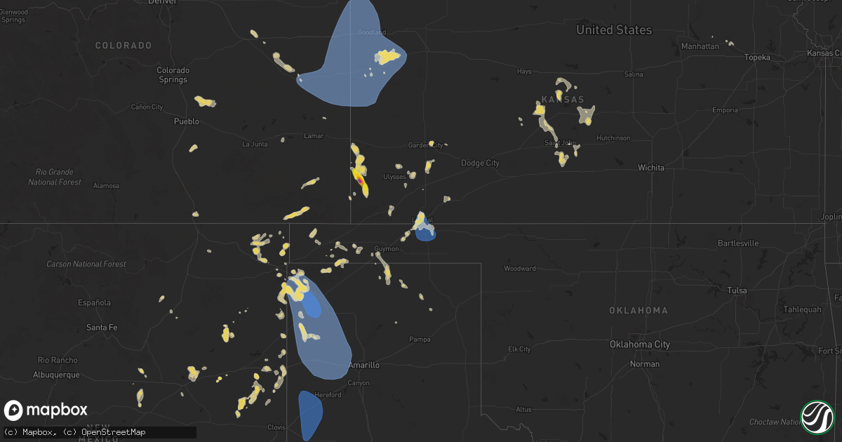
Hail Map on July 5, 2025
Get this storm
July 5 map
$229
one time, instant access
Download today. No call, no setup
Keep the $229
Bought the map and want the full workflow? Apply the entire $229 to a subscription within 7 days. None of it is wasted.
Every map, not just this one
This buys you this map. Subscription and you get every map we run, in the markets you choose from a few cities to whole states to nationwide. Plus real-time alerts the moment a storm fires.
Contact data
Name, contact info, occupancy, even credit band for addresses in the footprint. You go from where it hit to who to call.
Become the source they trust
Unlimited branding weather history reports on demand. You already have the documented answer ready for the property owner, and you are the one who showed up with it.
Property data and RoofTrace estimates
Pull up any address you have got, its value and the exact code rules for that jurisdiction, straight from One Click Code. Then RoofTrace estimates the squares, pitch, and roof value, priced the way you price.
States Impacted by Hail Map on July 5, 2025
Storm reports
Alabama
| Date | Description |
|---|---|
| 07/05/20254:54 PM CDT | Corrects previous hail report from 2 wsw grand bay. Broadcast media shared photo of nearly half dollar sized hail. Photo was taken at highway 90 near mile marker 2. |
| 07/05/20254:49 PM CDT | Em reports powerlines down at grand bay wilmer road and warren creek road. Time estimated via radar. |
Wyoming
| Date | Description |
|---|---|
| 07/05/20252:20 PM CDT | Trained spo |
| 07/05/20252:20 PM CDT | Trained spotter. |
| 07/04/20259:52 PM CDT | Mesonet station wy47 casper 2.1 sw |
| 07/04/20259:50 PM CDT | Mesonet station pc377 scenic dr. |
| 07/04/20258:54 PM CDT | Asos station krks rock springs airport. |
| 07/04/20258:50 PM CDT | Photos show multiple large trees uprooted |
| 07/04/20258:42 PM CDT | A local report indicates 73 MPH wind near Beulah |
| 07/04/20258:33 PM CDT | A local report indicates 66 MPH wind near 5 SW Aladdin |
| 07/04/20258:30 PM CDT | A local report indicates 60 MPH wind near 5 SW Aladdin |
| 07/04/20257:35 PM CDT | Pea sized hail |
| 07/04/20257:19 PM CDT | A local report indicates 64 MPH wind near 17 NNW New Haven |
Minnesota
| Date | Description |
|---|---|
| 07/05/20251:05 PM CDT | [landspout] brief landspout reported by law enforcement and social media near welcome. |
Montana
| Date | Description |
|---|---|
| 07/05/20256:05 PM CDT | A local report indicates 59 MPH wind near 2 NNE Sayle |
| 07/05/20255:54 PM CDT | A local report indicates 70 MPH wind near 10 E Birney |
| 07/05/20255:27 PM CDT | A local report indicates 1.00 inch wind near 3 W Lame Deer |
| 07/05/20255:10 PM CDT | A local report indicates 60 MPH wind near 3 ENE Muddy |
| 07/05/20254:35 PM CDT | Corrects previous hail report from 11 nw busby. |
| 07/05/20254:30 PM CDT | Mesonet station mting 1.6 w ingomar |
| 07/05/20254:15 PM CDT | A local report indicates 58 MPH wind near 6 SSE Myers |
| 07/05/20253:46 PM CDT | Report from mping: golf ball |
| 07/05/20252:34 PM CDT | Asos station kbil billings. |
| 07/04/20258:41 PM CDT | Mesonet station armm8 armells creek raws. |
| 07/04/20258:15 PM CDT | A local report indicates 70 MPH wind near 2 ESE Alzada |
| 07/04/20257:15 PM CDT | Mesonet station mtden denton |
| 07/04/20257:07 PM CDT | Multiple tree branches down... Up to 3 inches in diameter. |
Colorado
| Date | Description |
|---|---|
| 07/05/20256:58 PM CDT | Awos station kako akron. |
| 07/04/20259:27 PM CDT | Site up694 reports wind gust to 62 mph. |
| 07/04/20258:55 PM CDT | Site kitr reports 63 mph wind gust. |
| 07/04/20258:52 PM CDT | Site co068 reports 61 mph wind gust. |
| 07/04/20258:46 PM CDT | Site kcocheye8 reports 62 mph wind gust. |
| 07/04/20258:24 PM CDT | Site up729 reports wind gust of 62 mph. |
Illinois
| Date | Description |
|---|---|
| 07/05/20256:09 PM CDT | A section of a large tree was reported down in dakota... Il. Time is estimated from radar. |
South Dakota
| Date | Description |
|---|---|
| 07/05/20252:25 PM CDT | A local report indicates 1.00 inch wind near Hot Springs |
| 07/05/20252:20 PM CDT | A local report indicates 1.00 inch wind near 1 NNW Hot Springs |
| 07/05/20252:18 PM CDT | A local report indicates 1.25 inch wind near 1 NE Cottonwood Springs |
| 07/05/202512:12 AM CDT | A local report indicates 70 MPH wind near 1 NE Kadoka |
| 07/04/202511:40 PM CDT | A local report indicates 63 MPH wind near 4 E Cactus Flat |
| 07/04/202511:30 PM CDT | A local report indicates 74 MPH wind near 2 E Cottonwood |
| 07/04/202511:26 PM CDT | A local report indicates 68 MPH wind near 6 W Cottonwood |
| 07/04/202510:50 PM CDT | A local report indicates 66 MPH wind near 3 NW Wasta |
| 07/04/202510:45 PM CDT | A local report indicates 58 MPH wind near Wasta |
| 07/04/202510:40 PM CDT | A local report indicates 68 MPH wind near 3 NW Wasta |
| 07/04/202510:30 PM CDT | A local report indicates 60 MPH wind near 6 WSW Fairpoint |
| 07/04/202510:07 PM CDT | A local report indicates 67 MPH wind near Rapid City Arpt |
| 07/04/20259:55 PM CDT | A local report indicates 72 MPH wind near 13 NE Newell |
| 07/04/20259:50 PM CDT | A local report indicates 59 MPH wind near 7 NNE Ellsworth AFB |
| 07/04/20259:35 PM CDT | A local report indicates 65 MPH wind near 1 NNW Nisland |
| 07/04/20259:30 PM CDT | A local report indicates 62 MPH wind near 1 NNW Nisland |
| 07/04/20259:20 PM CDT | A local report indicates 59 MPH wind near 1 NNW Nisland |
| 07/04/20258:56 PM CDT | A local report indicates 64 MPH wind near 27 WNW Castle Rock |
| 07/04/20258:55 PM CDT | A local report indicates 58 MPH wind near 4 E Dwtn Spearfish |
| 07/04/20258:50 PM CDT | Pea to dime sized hail |
| 07/04/20258:50 PM CDT | A local report indicates 63 MPH wind near 13 NW Belle Fourche |
| 07/04/20258:40 PM CDT | A local report indicates 67 MPH wind near 13 NW Belle Fourche |
| 07/04/20258:35 PM CDT | A local report indicates 65 MPH wind near 13 NW Belle Fourche |
| 07/04/20258:30 PM CDT | A local report indicates 60 MPH wind near 13 NW Belle Fourche |
| 07/04/20258:19 PM CDT | A local report indicates 72 MPH wind near 8 NW Colony |
Kansas
| Date | Description |
|---|---|
| 07/05/20256:05 PM CDT | A local report indicates 2.00 inch wind near Manter |
| 07/05/20256:00 PM CDT | A local report indicates 1.50 inch wind near Manter |
| 07/04/202511:20 PM CDT | Pws - nwkecounty. |
| 07/04/202511:09 PM CDT | Pws - kkslakin28. |
| 07/04/202510:53 PM CDT | Upr-mclas. |
| 07/04/202510:31 PM CDT | Site dw9439 reports 62 mph wind gust. |
| 07/04/202510:24 PM CDT | Site 5.5m e tribune ks reports 72 mph wind gust. |
| 07/04/202510:23 PM CDT | Site c6099 reports 59 mph wind gust. |
| 07/04/202510:13 PM CDT | Trained spotter estimates winds around 58 mph. Supported by sending in a video. |
| 07/04/202510:07 PM CDT | Spotter estimates 60 mph wind gusts and near zero visibility in rain on hwy 96 near ks/co border. |
| 07/04/20259:30 PM CDT | Cwop site gw6138. |
| 07/04/20258:00 PM CDT | Report made via social media. |
| 07/04/20257:57 PM CDT | Mesonet station up352 2.7 sw liberal |
| 07/04/20257:56 PM CDT | Awos station klbl liberal. |
North Carolina
| Date | Description |
|---|---|
| 07/05/20253:27 AM CDT | An nws survey team found damage consistent with a weak tornado near the kings grant subdivision in wilmington... Nc and along cornelius moor avenue and acorn branch roa |
Texas
| Date | Description |
|---|---|
| 07/04/202510:50 PM CDT | Measured by the ttu mesonet. |
| 07/04/20259:03 PM CDT | Mesonet station 109 adrian 6wsw. |
| 07/04/20258:31 PM CDT | Mesonet station 118 romero 11ssw. Severe gusts started at 817 pm and continue through 837 with peak occurring at 8:31 pm. |
| 07/04/20257:50 PM CDT | Severe wind gusts occurred at the dalhart 12sw mesonet site from a likely anvil gust from a nearby thunderstorm. The mesonet site initially gusted to 61mph at 0749pm... |
Iowa
| Date | Description |
|---|---|
| 07/05/20254:54 PM CDT | Delayed report. Large tree across road in subdivision. Time estimated from radar. |
| 07/05/20254:53 PM CDT | Retired nws employee relayed photo on x of a large tree branch down in park view. Time estimated by radar. |
| 07/05/20254:09 PM CDT | Relayed report of a tree branch of unknown size was down one miles south of moscow. |
| 07/04/20257:35 PM CDT | 6 inch tree branch snapped off tree. 48 mph gust. |
Cities Impacted by Hail Map on July 5, 2025
- Lodgepole, NE
- Dalton, NE
- Broadwater, NE
- Lisco, NE
- Marion, TX
- McQueeney, TX
- Seguin, TX
- New Braunfels, TX
- Bulverde, TX
- Custer, SD
- Reed Point, MT
- Big Timber, MT
- Pinedale, WY
- Bondurant, WY
- Cora, WY
- Molt, MT
- Hot Springs, SD
- Billings, MT
- Broadview, MT
- Huntley, MT
- Berthoud, CO
- Worden, MT
- Ballantine, MT
- Pompeys Pillar, MT
- Hardin, MT
- Buffalo Gap, SD
- West Point, NE
- Richton, MS
- Llano, TX
- Roundup, MT
- Saint Xavier, MT
- Dodge, NE
- Scribner, NE
- Moss Point, MS
- Crow Agency, MT
- Custer, MT
- Powell, WY
- Malta, MT
- Brooklyn, MS
- Perkinston, MS
- Wiggins, MS
- Bighorn, MT
- Eglin Afb, FL
- Roy, MT
- Lumberton, MS
- Hysham, MT
- Forsyth, MT
- Garryowen, MT
- Grand Bay, AL
- Syracuse, KS
- Ribera, NM
- Mobile, AL
- Lima, MT
- Pritchett, CO
- Grenville, NM
- Busby, MT
- Ocate, NM
- Lame Deer, MT
- Anton Chico, NM
- McLain, MS
- Clayton, NM
- Rosebud, MT
- Ingomar, MT
- Garden City, KS
- Manter, KS
- Johnson, KS
- Louin, MS
- Raleigh, MS
- Lucedale, MS
- Birney, MT
- Otter, MT
- Campo, CO
- Boise City, OK
- Rozel, KS
- Ashland, MT
- Ulysses, KS
- Benson, AZ
- Limon, CO
- Satanta, KS
- Larned, KS
- Otis, KS
- Molino, FL
- Cantonment, FL
- Genoa, CO
- Bison, KS
- Conchas Dam, NM
- Pierceville, KS
- Elkhart, KS
- Walsh, CO
- Robertsdale, AL
- Richfield, KS
- Hoisington, KS
- Ingalls, KS
- Texline, TX
- Sublette, KS
- Sedan, NM
- Dalhart, TX
- Springfield, CO
- Hugoton, KS
- Broadus, MT
- Alzada, MT
- Weston, WY
- McDavid, FL
- Denton, MT
- Hatfield, MO
- Hulett, WY
- Moorcroft, WY
- Aladdin, WY
- Liberal, KS
- Texhoma, OK
- Eagleville, MO
- Lewistown, MT
- Plains, KS
- Saint Marys, KS
- Hugo, CO
- Amistad, NM
- Otis, CO
- Kit Carson, CO
- Hilger, MT
- Flagler, CO
- Tyrone, OK
- Turpin, OK
- Hooker, OK
- Nara Visa, NM
- Yuma, CO
- Hartley, TX
- Belle Fourche, SD
- Sundance, WY
- Channing, TX
- Vega, TX
- Adrian, TX
- Beaver, OK
- Forgan, OK
- Logan, NM
- Tucumcari, NM
- Clearmont, MO
- Alva, WY
- Beulah, WY
- Spearfish, SD
- Saint Onge, SD
- San Jon, NM
- Santa Rosa, NM
- Burlington Junction, MO
- Belvue, KS
- Whitewood, SD
- Fort Meade, SD
- Sturgis, SD
- Nisland, SD
- Newell, SD
- Vale, SD
- Bard, NM
- Goodwell, OK
- Hereford, TX
- Wildorado, TX
- Amarillo, TX
- Colorado Springs, CO
- Piedmont, SD
- Box Elder, SD
- New Underwood, SD
- Owanka, SD
- Union Center, SD
- Idalia, CO
- Goodland, KS
- Sharon Springs, KS
- Eads, CO
- Weskan, KS
- Arapahoe, CO
- Tribune, KS
- Saint Francis, KS
- Burlington, CO
- Bethune, CO
- Kanorado, KS
- Sheridan Lake, CO
- Cheyenne Wells, CO
- Edson, KS
- Boone, CO
- Broadview, NM
- Mcalister, NM
- Gruver, TX
- Grady, NM
- Wallace, KS
- Melrose, NM
- Rapid City, SD
- Ellsworth Afb, SD
- Wasta, SD
- Enning, SD
- Osage, WY
- Upton, WY
- Winona, KS
- Spearman, TX
- Perryton, TX
- Newcastle, WY
- Claflin, KS
- Wall, SD
- Friona, TX
- Bovina, TX
- Muleshoe, TX
- Farwell, TX
- Summerfield, TX
- Dimmitt, TX
- Leoti, KS
- Colby, KS
- Monument, KS
- Dorrance, KS
- Wilson, KS
- Borger, TX
- Edgemont, SD
- Kadoka, SD
- Bunker Hill, KS
- Philip, SD
- Hill City, SD
- Russell, KS
- Lyons, KS
- Bushton, KS
- Chase, KS
- Ellinwood, KS
- Cuervo, NM
- White River, SD
- Long Valley, SD
- Hermosa, SD
- Miami, TX
- Albert, KS
- Rush Center, KS
- Keystone, SD
- Quinn, SD
- Raymond, KS
- Alden, KS
- Newkirk, NM
- Pawnee Rock, KS
- Lead, SD
- Great Bend, KS
- Sterling, KS
- Deadwood, SD
- Coffee Creek, MT
- Winifred, MT
- Nemo, SD
- St John, KS
- Stafford, KS
- Sylvia, KS
- Macksville, KS
- Iuka, KS
- Turon, KS
- Chadron, NE
- Valentine, NE
- Hay Springs, NE
- Moriarty, NM
- Rushville, NE
- Wood Lake, NE
- Pine Ridge, SD
- Tinnie, NM
- Vaughn, NM
- Ellsworth, NE
- Porcupine, SD
- Wounded Knee, SD
- Batesland, SD
- Wanblee, SD
- Manderson, SD
- Oglala, SD
- Martin, SD